A Walk through the Garden of Suffolk
|
Friday 18 January 2019
|
No comments |
![]()
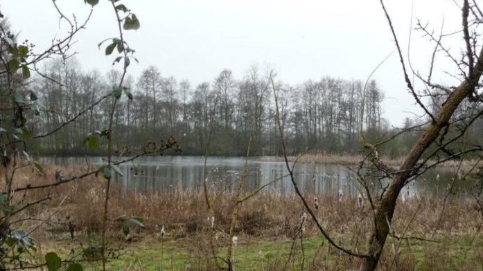
A 14 mile walk between Saxmundham and Darsham along the East Suffolk Line Walk.
It is Yoxford that gives us the name of this walk which is part of the East Suffolk Line Walks and this specific ramble extends the line walk to return to Leiston where a regular bus service connects the two ends. Yoxford sits on the banks of the River Yox surrounded by three country house parks; Sibton Park that contains large well stocked fishing lake; Grove Park situated in the village; and Rookery Park on the Leiston road. This has earned Yoxford the name of the 'Garden of Suffolk'. The whole route of this walk is a pleasant amble through the rural fields of Suffolk with a return journey through the pretty country lanes following the Minsmere river through to Middleton, Theberton and finally Leiston.
A Walk Through the Garden of Suffolk. - Essential Information
Walk Statistics:
- Start location: Saxmundham
- End location: Darsham
- Distance: miles ( km)
- Total Gain: ft ( metre)
- Total Descent: ft ( metre)
- Min Height: ft ( metre)
- Max Height: ft ( metre)
- Walk Time:
- Walk type: Linear
- Walk Grade: Easy
- Terrain:
Maps:
The following maps and services can assist in navigating this route. There are links to printed maps and links to downloadable GPX route data for importing into navigational software and apps.
- Ordnance Survey Explorer Map
- OS Explorer 212 - Woodbridge & Saxmundham
- GPX Route File
Transport:
Details of public transport that is required for the walk
First Group - Bus Service
- Service Details
- 64 - First Group 64 service connects Ipswich, Woodbridge, Wickham Market, Saxmundhamm, Leiston and Aldeburgh.
- Timetable
- Suffolk On Board Website
Route Verification Details
- Date of Walk: 2011-03-05
- Walk Time: 10:30 to 17:00
- Walkers: Griffmonster, Kat
- Weather Conditions: Started overcast with some mizzle throughout the day
Walk Notes
This walk was inspired by the East Suffolk Line Walks, a series of walks between the stations of the East Suffolk Railway Line that links Ipswich and Lowestoft. This particular walk was specific to the route between Saxmundham and Darsham stations, but is extended to include pubs, more Suffolk countryside and a full days ramble. The two ends of the walk between Leiston and Saxmundham are linked by an hourly bus service.
This isntance of the walk was undertaken as the first signs of spring were appearing after a very wet winter. Although the fields were predominantly dry, the ditches and brooks were all full of water. It also amazing to see just how many natural ponds there are throughout this area. A true wonder.
Yoxford is entered through Rookery Park, one of the three parklands that surround the village, the others being Sibton Park that contains large well stocked fishing lake and Grove Park which is in the village itself. Early spring is probably not the best time to witness Rookery Park as it is rather lifeless in its fauna. Having said this , the lane from the park to the road is full of snowdrops and daffodils along its borders during this time of the year. Revisiting this walk during the Summer months the scene is entirely different and a lush and delightful parkland.
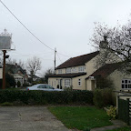
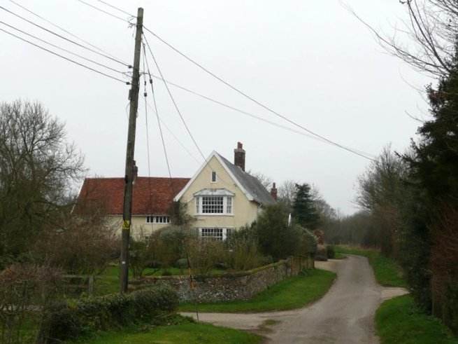
Darsham station is on the main A12 and if one wants to terminate the walk here then there is an hourly service back to Saxmundham. However, we continue onward to the village of Darsham where there is a charming country pub that goes by the name of The Fox. This is well renowned locally for its food. This is followed by walks along country lanes to Middleton where the Bell is another pub worthy of a visit.
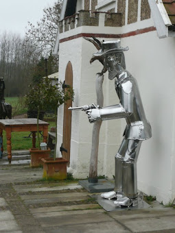
The path out of Middleton passes the home of Paul Richardson, the sculpture whose fascinating works of art adorn the grounds around his cottage including the silver gun slinger that stands on the roadside and draws attention to any passing motorist.
Across the marsh and over the fields one arrives at Theberton where there is the humble thatched church that contains part of the Zeppelin that was brought down here during WWI. This is contained in the church porch and one should always pay it a visit. In the cemetery across the road is a memorial to the German airman who perished during this event.
The final section uses lanes and footpaths into Leiston. For those who are new to the town, then the Long Shop Museum is well worth a visit, particularly during one of their many event days when traction engines, steam cars and their own Serapite steam engine are in steam. The museum is located in the production hall to the old Garrett works, world renowned for their traction engines. Go to any steam rally and one will almost certainly witness an engine with the words Garrets appearing on its boiler front. They were all constructed here.
Directions
Saxmundham to Darsham
East Suffolk Line Garden of Suffolk Walk:The East Suffolk Line walk leads out of Saxmundham on the right hand side of the railway bridge as you head north out of the town. The path is clearly marked using the distinctive coloured waymarkers. Follow the railway line to the Sizewell branch junction, cross the railway and the path leads across the field to a road. Turn right and walk up the road for a hundred yards. A path on the left leads through to the Kelsale road. Cross the road and the path continues a few yards to the right. Where the path branches turn right. This comes out at Redhouse Farm. Turn left on the road and where the road bends to the left take the track on the right past Rubblestone farm. A footpath on the left cuts across a small field then heads down to Yoxford wood then up to another country lane. Turn right and follow the lane through to Fordley Hall, turn left up the hill and when the road bends round to the right there's a path that leads down the hill, across the railway and into Rookery Park. Cross the park and emerge on the A12 double bend in Yoxford. Theres a footpath alongside the A12 all the way through to the Darsham junction on the right. If this is as far as you want to travel a return journey can be made from Darsham station which you pass on the A12. The Fox Inn is on the right at the first junction in the village.
Darsham to Leiston
Darsham to Leiston return walk:From the Fox Inn, head out on the country lane down to the Westleton Road. Walk along here until there is a single track lane on the right. Take this until it reaches a farm on the left. A footpath on the right takes you through to Middleton. The Bell Inn is a hundred yards on the right as the road bends round. Take the path through the church yard and continue up the lane to just past the playing field. Turn left and continue until it meets the road. Turn right and take the track down by Fenn Farm on the right. Eventually this comes out on a lane in Theberton, Turn right till it junctions with the road, turn right and this brings you out onto the main road with the church on the left and the Lion Inn opposite. From the Lion walk south for a few yards and a footpath on the right will take you round the back of the houses and across a field to a T-junction of roads. Continue straight on until you meet a farm on the left. A footpath takes you around the back of the farm and leads alongside the field. Continue across the fields in almost a straight line all the way through to geaters nurseries in Leiston. turn right at the road and a path on the left crosses the railway and leads through to Waterloo Avenue. Leiston town centre is directly left up Waterloo Avenue.

Pubs
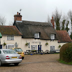
The Fox Inn, Darsham View in OS Map | View in Google Map
- Address
- Fox Lane, Darsham
Records show that this has been a pub since the mid 19th century and has been referenced as Cheyny Green (1851), Chainer green (1861) and China Green according to the Suffolk CAMRA website. Traditional family run free house with food and accommodation available. Small rooms beams across the ceiling and open fires. Enormous amount of Fox based ornamentation throughout the bars.
I was somewhat disappointed to find that this freehouse only served Adnams. I had half expected to find something from a Suffolk or Norfolk micro-brewery. Nonetheless, there was no complaints about the quality of ale, and the warming soup was very soothing, overcast day!
The Bell , Middleton View in OS Map | View in Google Map
- Address
- The Green, Middleton
- Website
- www.themiddletonbell.co.uk/
There is rumour that the Bell used to brew beer for the monks of Leiston Abbey which would indicate the pub was here before the dissolution of the Monasteries in 1537 which is most certainly earlier than the age of the present building, which is believed to be 17th century. There is no doubt that the church was served by the Abbey but stories about reciprocation by the pub may just be wishful conjecture
The pub is presented as a charming old fashioned village local, part-thatched with a small public bar and wooden floors, rustic table and chairs, low ceilings, oak beams and open fireplace. The ale is gravity served from a back bar. There is a large garden that leads down to a small stream amid unspoilt meadows. this is an Adnams house and as such there is a regular standard selection of their ales available.
You cant beat the Adnams bitter that is served here. Straight from the barrel and always excellent.
The Lion Inn, Theberton View in OS Map | View in Google Map
- Address
- The Street, Theberton
- Website
- https://www.facebook.com/thebertonlion/
The pub was known as the White Lion between 1844 and 1881 and it has been suggested that it was also known as the Red lion at one time. However the Lion Inn moniker has persisted throughout, both before and after such name changes.
This is a friendly village local offering guest ales and home cooked food. Accommodation available.
This unassuming pub on the main road is an oasis for anyone who savours their drinks. Not only a fine selection of ale but every keg beer and cider and stout is all produced by local brewers. On this paritcular visit, the barstaff swooned when a famous TV soap actor entered the building as we supped at the bar. I am not a television aficionado so did not recognise the chap. I dont think he was particularly offended.
Features
The Devil's stone, FordleyView in OS Map | View in Google Map
An old piece of local folklore
In his book entitled 'An Hour-Glass on the Run', published in 1959, Michael Joseph declares that in the yard at the now-ruined Home Farm there is reputedly a huge boulder where children were once in the habit of placing pins in the various cracks and holes, running round it as fast as they could, then putting their ears against it in the hope of hearing the Devil speak.
Home Farm used to be on the site of what is now Vale Farm but it was across the road near Fordley Hall where the stone is supposed to be, though I must admit, I could not locate it! Legend states that there is a hoard of treasure buried beneath the stone but that it is immovable. A local farmer is said to have attempted to wrench it away from its position by attaching a team of horses to it but they failed to move it. It is also said to have been the meeting place for a coven of witches.
Rookery Park, YoxfordView in OS Map | View in Google Map
19th century landscaped parkland at Yoxford
Created in the mid 19th century this parkland includes Lebanon cedars, Scots pine, oak and sequoias together with circular arrangements of yews. A narrow tree belt in a horseshoe arrangement separates the house and park from Rookery Cottages which date from the 16th/17th centuries. Along the north western boundary, neighbouring on Yoxford village is Pins Wood, a beech wood with snowdrop's and daffodils in the spring. From the undulating south side there are views across to Grove Park and Cockfield Hall along with the village. Running through the centre of the southern park in a east-west direction is a significant hedgerow that marks an ancient field boundary.
Church of the Holy Trinity, MiddletonView in OS Map | View in Google Map
The 12th century parish church of Middleton
There used to be two churches in Middleton back in 1620. They stood a mere 50 yards away from each other. Their close proximity meant that each others bells would interfere with the others services. This became such a problem that complaints were made to the Bishop of Norwich who resolved the matter by only allocating one priest for the two churches. Soon after the Bishops judgement, the Fordley church was demolished and now there is no evidence of it remaining other than a few stones and a sarcophagus cover on display in the present church. This church is distinctive with its zinc spire atop its tower. The present building dates from the 12th and 13th centuries but it is said that an Anglo Saxon structure of flint and stone pre-dated it, though no traces of this remain. A fire in 1955 destroyed its original thatch roof which has now been replaced with tiles.
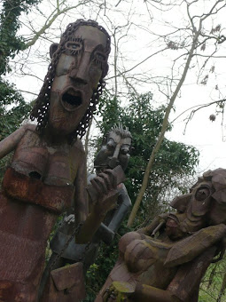
Paul Richardson's Steel Sculptures, MiddletonView in OS Map | View in Google Map
Larger than life metal sculptures and caricatures
This is a real treat that makes walking so worthwhile. The footpath that crosses the fields from Theberton descends across a marsh before coming back up to Middleton where it joins the road by a cottage named Ambleside. This is the residence of Suffolk Sculptor Paul Richardson. He sculpts in metal and his house is surrounded by examples of his work which are larger than life caricatures which, to say the least, are impressive. No-one who walks past this house can escape their curiosity and take time out to look at these magnificent works of art. Other examples of his work can be seen on peering out of the top of an Ipswich public convenience and in Ipswich Hospital.
References
The Theberton ZeppelinView in OS Map | View in Google Map
The story of the German Zeppelin which crash at Theberton in 1917
During the end of First world War the Germans started to deploy vast airships, commonly known as Zeppelins. The 48th of these, L48 was on her first operational flight with a task to attack London. She drifted over Orford Ness and dropped her bombs on Harwich and Martlesham and then turned to head for home. However, her compasses had frozen and instead of heading east, she drifted northwards where she came under attack from British anti-aircraft fire. At two o'clock on the morning of June 17th the Zeppelin crashed just outside Theberton, its fiery body glowing in the sky as it came down and it is said could be seen for miles around. Of the 19 crew, 16 were killed with 3 survivors, one of whom was taken to a local house for safe keeping until the authorities arrived. It is said that the homeowners reply to such a request was 'Not likely lock the bugger in the shed'. Those killed were buried in St Peters Church at Theberton. In the mid 1960`s these were exhumed and re-buried at the German cemetery in Cannock Chase Staffordshire. There remains a memorial to those who perished which is located in the graveyard extension over the road to the church. An inscription reads 'Here were buried 16 German airmen crew of Zeppelin L48 17th June 1917 "who art thou that judges another mans servant"'. In the porch of the church is a glass fronted frame which contains a section of the L48 and below this is a brief history of the event.

Links and Bibliography:
Gallery
Below are a selection of images taken from from the photo album for this walk. Feel free to browse through these or click on an image to view a larger version in the Gallery.


Summary of Document Changes
Last Updated: 2021-12-07
Circular Walk, Distance:long, East Suffolk Line Path, Features:Churches and abbeys, Features:Folklore, Features:Local History, full-detail, OSmap:212, Suffolk


0 comments:
Post a Comment