An Amble up the Deben Estuary
|
Monday 21 January 2019
|
1 comment |
![]()
A 13 mile walk along the River Deben in Suffolk, starting at Felixstowe and ending in Martlesham
The lovely walk along the Deben estuary. Although parts are inaccessible due to breaches of the flood banks, the mix of riverside paths, country lanes and footpaths provides an ideal mix of landscapes to keep any walker fascinated. The May bush pub offers a perfect place to take a rest and refreshment, its riverside location unbeatable.
Felixstowe to Martlesham via the Deben Estuary - Essential Information
Walk Statistics:
- Start location: Great Eastern Square, Felixstowe
- End location: Martlesham
- Distance: miles ( km)
- Total Gain: ft ( metre)
- Total Descent: ft ( metre)
- Min Height: ft ( metre)
- Max Height: ft ( metre)
- Walk Time:
- Walk type: Linear
- Walk Grade: Easy
- Terrain:
Maps:
The following maps and services can assist in navigating this route. There are links to printed maps and links to downloadable GPX route data for importing into navigational software and apps.
- Ordnance Survey Explorer Map
- OS Explorer 197 - Ipswich, Felixstowe & Harwich
- GPX Route File
Transport:
Details of public transport that is required for the walk
First Group - Bus Service
- Service Details
- 64 - First Group 64 service connects Ipswich, Woodbridge, Wickham Market, Saxmundhamm, Leiston and Aldeburgh.
- Timetable
- Suffolk On Board Website
First Group - Bus Service
- Service Details
- 75/76/77 - First Group 75/76/77 bus services connecting Ipswich, Trimley and Felixstowe.
- Timetable
- Suffolk On Board Website
Route Verification Details
- Date of Walk: 2011-04-23
- Walk Time: 09:15 to 15:15
- Walkers: Griffmonster, Kat
- Weather Conditions: Very warm day with bright sunshine and clear blue skies. A fresh breeze along the coast to Felixstowe Ferry
Walk Notes
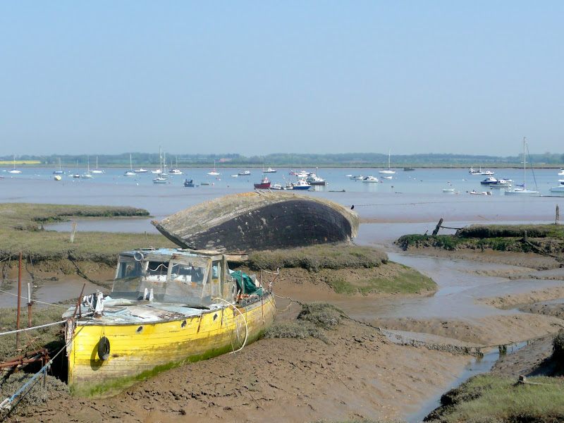
The Felixstowe side of the River Deben estuary has public access as far as the village of Hemley. Beyond this the defence banks have been breached which necessitates inland footpaths, tracks and lanes. The riverside is met again at Waldringfield but another breach beyond this prevents access through to Martlesham Creek and alternative footpaths have to be accessed.
Despite this, the walk is still a voyage of discovery around parts of the Felixstowe peninsula that one would probably never visit other than on foot. Given a day such as when this walk was undertaken which had wall to wall sunshine and deep blue skies, the river estuary is at its best. A vast wide expanse of water with marsh on its borders and every creek and cranny something new to view. The river is well used by pleasure craft and given a fine weekend there are numerous yachts parading up and down the river. On the far shore one passes Ramsholt with its distinctive church sitting high on the hill above the river, its buttressed round tower quite unique to this area.
At Kirton Creek there are two options, either to follow the estuary a short distance further, or, as in this instance, take the footpath to the west of the woodland. No matter what route is chosen one will end up at the hamlet of Hemley - note that taking the riverside path one needs to head inland at the next opportunity as going beyond results in meeting with a breach across the defence bank.
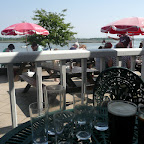
The route meets the river again at Waldringfield where the May Bush pub makes an ideal place to take a rest, have some lunch and a drink and watch the river from the benches that adorn the frontage of the pub. This is a popular place and can get very busy as it is all about location and this is in one of the best.
The final stage diverges away from the river side once again, the paths beyond Waldringfield breached. There is a short walk across to Martlesham Creek. In this instance we take the path through the woodland to Martlesham. An optional route is to follow the river side path around the creek and up to Woodbridge.
The two ends of the walk can be linked by public transport via Ipswich. It has to be said that taking the bus to the start then provides a full day with no worries about catching the bus back.

Directions
>Follow the seafront from Felixstowe through to Felixstowe Ferry and then follow the Stour and Orwell Path inland route. This will soon depart inland but stick with the footpath along the river defences until it meets Kirton Creek. From here head inland along a track up to the village of Hemley then across fields and back down to the riverside at Waldringfield. From Waldringfield a country lane leads through to MArtlesham creek where there is the option to follow the Fynn Valley path up to Martlesham or continue around the creek and into Woodbridge.
Felixstowe to Waldringfield
From Felixstowe take High Road East out to where it meets the coast. Here there is a path along the seafront all the way through to Felixstowe Ferry. At the end of the path, immediately across the road is the way marker for the Stour and Orwell Path inland route which leads along the river defences. The Path soon departs inland along Kings Fleet but keep with the well defined footpath along the top of the defences. Continue through to Kirton Creek recognisable by the wood on the opposite shore to the creek. Take the track down alongside the wood which leads up to the village of Hemley. At the end of the track, turn left by the church and follow the lane and the right by the church tower. Continue until it meets a road. Here there is a track on the right next to a cottage. At the end of the track a footpath on the left will lead through to Waldringfield, coming out on the shore of the Deben by the Sailing Club.
Waldringfield to Martlesham Creek
Take the road by the May Bush up through the village. The road turns a sharp right and can be fairly busy, but stick with this to the village end where there is a cross roads with the main road departing to the left. Take the lane straight ahead and follow this all the way until there is a Sandlings Path waymarker on the right. Take this footpath across the fields to Martlesham Hall where it turns sharp left and follows the road for a few hundred yards where it crosses the road and goes down a steep wooded bank to Martlesham Creek.
Martlesham Creek to Martlesham
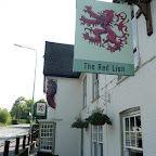
Just before the path comes out of the wooded area to run alongside the creek there is a Fynn Valley Path waymarker pointing to a footpath on the left just inside the woods. This follows the woods and comes out on School Lane, Martlesham. Turn right at the road and at the junction with the Red Lion Pub opposite turn right where there is a bus stop just up the road.

Pubs
May Bush, Waldringfield View in OS Map | View in Google Map
- Address
- May Bush, Waldringfield
- Website
- www.debeninns.co.uk/maybush/
Originally a 14th century farmhouse, it is thought to have become a pub in the mid 1700's. Present day it is a popular Deben Inns establishment on the banks of the Deben with panoramic views across the river and beyond. A varied menu offers local game, meats and fresh seafood with Adnams ales are on offer.
Very busy owing to the fact that it was the Easter Weekend. Nonetheless we found a vacant table on the veranda which offered some welcome shade. A pint of Adnams Gunhill and the barman refilled our water bottles without complaint. Very hospitable staff.
Red Lion, Martlesham View in OS Map | View in Google Map
- Address
- Red Lion, Martlesham
- Website
- https://www.chefandbrewer.com/pubs/suffolk/red-lion/
A 16th century Coaching Inn which was used as an overnight stopover for the Royal Mail between Norwich and London. This is now a Chef and Brewer establishment but retains its old oak beams and large open fireplaces. Friendly and welcoming with food and guest ales on offer.
Arrived at 2pm and we were the only customers in this pub. They had Sharps Atlantic IPA on cask which was a very rewarding and refreshing pint.

Features
WaldringfieldView in OS Map | View in Google Map
It is said that there was a settlement at Waldringfield as far back as the iron age. It is certainly listed in the Domesday Book of 1086, the name then being Waldingafelda. There is little more history until more recent times when, during the latter part of the 19th century, the village became an important port for coprolite shipments to Ipswich. Coprolite is a fossilized animal dung which was dug from pits in the fields around Waldringfield and was used in the fertiliser industry. Around this time, cement making also sprang up in the area with barges bringing in the raw materials from the Medway and then taking back the coprolite on their return. At its height Waldringfield provided achorage for a fleet of Thames barges, snows, billybouys, ketches and schooners. The industries receded when phosphates began to be used in fertilisers making the coprolite of little worth. By the early 1900's both coprolite and cement industries had completely gone. In 1921 the Sailing Club was created and this set the trend for the modern day Waldringfield becoming orientated towards the leisure industry.
References
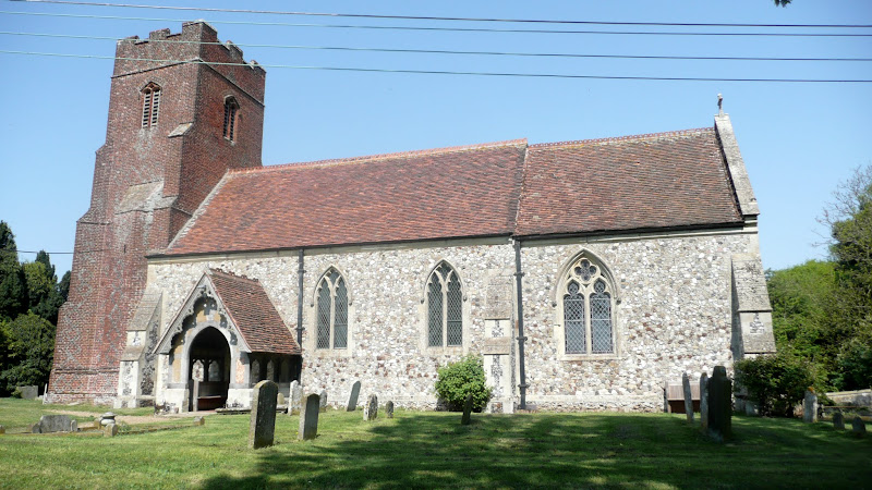
All Saints Church, HemleyView in OS Map | View in Google Map
The church of All Saints at Hemley dates from the late tudor period, of which the tower is the only remaining remnant, the rest of the building being from Victorian times when the church was completely rebuilt after falling into complete decay. The font, however, dates from the mid-13th century indicating that a structure predating the Tudor tower once existed here.
References
Gallery
Below are a selection of images taken from from the photo album for this walk. Feel free to browse through these or click on an image to view a larger version in the Gallery.


Summary of Document Changes
Last Updated: 2021-12-07
Coast Walk, Distance:long, Features:Churches and abbeys, Features:Local History, full-detail, OSmap:197, Riverside Walk, Suffolk


My daughter in law's mom l used to live in Felixtowe where I visited her and just adored these river walks and pubs... such peace and richness of its history... what a river ! has a life of its own...that man could never copy.. and it doesnt need us ! we need it instead ,, to drink of its eternal beauty !
ReplyDelete