Fynn Valley Circular Walk
|
Wednesday 21 November 2018
|
1 comment |
![]()
A 16 mile walk along the Suffolk Fynn Valley between Woodbridge and Witnesham, with a return route via Grundisburgh and Hasketon.
The Fynn Valley Walk is an official waymarked route following the course of the River Fynn from Witnesham to Martlesham then continuing through to Woodbridge along the banks of the River Deben. For this walk, the Fynn Valley route is walked in reverse then public footpaths are used across the fields to Grundisburgh and Hasketon and back down into Woodbridge to make a circular walk.
Fynn Valley Circular Walk - Essential Information
Walk Statistics:
- Start location: Turban Centre, Woodbridge
- Distance: miles ( km)
- Total Gain: ft ( metre)
- Total Descent: ft ( metre)
- Min Height: ft ( metre)
- Max Height: ft ( metre)
- Walk Time:
- Walk type: Circular
- Walk Grade: Easy
- Terrain:
Maps:
The following maps and services can assist in navigating this route. There are links to printed maps and links to downloadable GPX route data for importing into navigational software and apps.
- Ordnance Survey Explorer Map
- OS Explorer 197 - Ipswich, Felixstowe & Harwich
- GPX Route File
Transport:
Details of public transport that is required for the walk
First Group - Bus Service
- Service Details
- 64 - First Group 64 service connects Ipswich, Woodbridge, Wickham Market, Saxmundhamm, Leiston and Aldeburgh.
- Timetable
- Suffolk On Board Website
Route Verification Details
- Date of Walk: 2011-05-07
- Walk Time: 09:20 to 16:30
- Walkers: Griffmonster, Kat
- Weather Conditions: Warm with sunny spells
Walk Notes
Although there is not a huge amount of history along this route, it is nonetheless a charming enough stroll through the Suffolk countryside. The River Fynn is not much more than a babbling stream throughout its course from Witnesham to its outlet into Martlesham Creek but presents a constant theme. There are a few pubs to take a worthy rest, particularly on the return journey where the Grundisburgh Dog and Hasketon Turks Head are both worth a visit.
There used to be a station at Little Bealings but alas that is no longer used, part of Dr Beechings infamous cuts. I have passed by the old station buildings many times on the train but have never realised it was Little Bealings station. This is the beauty of walking, putting the landscape into perspective. From now on when I use the train I will gaze upon Little Bealings station and the Fynn Valley in the new light of this discovery.
The path back from Witnesham starts by following the Sizewell bound pylons. Here, the gorund is 50m above sea level, that is a mountain by Suffolk standards and you can gaze across the landscape from up here!
A couple of years ago we had done a circular walk from Woodbridge to Grundisburgh as part of the Woodfordes Ale Trail. On this occasion we used the same footpaths between Grundisburgh and Hasketon and found that there is still an electric fence set across the public footpath. There is no mistaking that this is the footpath as there is a waymarker at the point the electric fence meets the hedge. Luckily the cables are terminated in isolators loosely placed over a metal hook on the end fencepost. Nonetheless this is a daunting prospect on meeting the fence, but it is a simple procedure to unhook the upper cable, carefully step over the lower cable then replace the upper cable.
One part we had been looking forward to was the wobbly bridge across the stream near Hasketon. The last time we encountered this it really was a wobbly bridge that bounced around as you walked across it. However, this time around it appeared to have been strengthened so that wobbly experience was not altogether complete!
We had hoped to pop into the Turks Head at Hasketon as this is a most charming community run pub but alas time was knocking on and we needed to catch the bus back to Leiston so this will have to wait for another time.

Directions
The walk follows the the banks of the Deben around to Martlesham Creek where it meets the River Fynn. The path then follows the rivers course through Little Bealings, Playford and Tuddenham St Martin through to Witnesham. Waymarkers point out the route throughout this section. The return is on footpaths across fields to Grundisburgh, then using further footpaths to Hasketon and finally back to Woodbridge
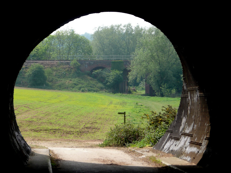
Woodbridge to Witnesham
This is the official Fynn Valley Walk which is clearly marked throughout. From the Turban Centre head down to the river and follow the path downstream. After a mile the path turns to navigate around Martlesham Creek. Continue around the creek until the path heads into woods on the far side. As you enter the woods. turn right just before the path marked as the Sandlings heads up the steep hill. The path continues through the woods and out onto School Lane. Turn right and proceed down the road to the junction. Turn right and follow the road under the railway and up to a sharp turn to the right. There is a lane on the left which leads down by the side of the main A12 and then through a tunnel under the carriageways and continues along the field edge to the left. Waymarkers lead across the fields roughly following the course of the River Fynn through to Little Bealings. When you meet the road, turn right and then take the footpath left down by the church which comes out on Sandy Lane. Follow the lane until it turns sharply left and the houses end. A path leads through some trees and scrub and along field edges to Hill Farm Road in Playford. Follow the road until it meets the main road, turn right and then the next left down Brook Lane. This leads out across fields, once again following the course of the river. Keep following the waymarkers. There is one point where the official route takes a left turn from the path with no waymarker, this will lead down and across the river and follow it into Tuddenham St Martin. This is very easy to miss and if done so do not worry as the path ahead will lead up to a lane, turn left and follow the lane into the village. On the left hand side of the bridge in the village the path leads on along the river banks. This leads all the way through to Witnesham, turn right on the main road to once again meet the river and here the official route ends.
Return via Grundisburgh
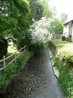
Continue through Witnesham until you come to Giles Way on the right. Follow this modern estate road and look out for the footpath signpost on the left before the road bears round to the right. This leads out to a country lane by a cottage. Cross the lane and another footpath leads along the field edges. When it meets a larger field, turn left along the field edge then navigate across the field. Despite footpath markers, this is not marked out very well by the farmer and you may well need to just follow the tractor tracks through the crops to the far side where it comes out onto a road. Turn left and take the footpath on the right a few yards up the road. This follows the field boundaries through a series of long thin meadows, across a lane then across another field into Grundisburgh. Turn left and follow the road round past the church and pub until it meets a junction. Continue on along Woodbridge Road until there is a small road on the left, go down here and on the right, just past the house a footpath leads out into the fields. Keep following the field edge and turn left with the hedge and down to the stream. Follow the stream through to a road. Turn left and almost immediately on the right a paved track leads off on the right. Keep a lookout for a gate on the right hedgerow. This leads onto a footpath through fields with horses. There is an electric fence at the far end but it has isolators on the end which allow you to lift it up and pass through. This is a public footpath so these restrictions should not be across the path. Eventually this path comes out onto a road. Continue straight ahead on the road and then follow the footpath a hundred yards on the left. This brings you out in Hasketon. Turn right and follow the road through Hasketon. At the church bear round to the left. Follow the road through until there is a track on the left with a footpath marker. Take this to the end and keep following the footpath signs through the fields until it meets the A12. Cross over and follow Haugh Lane down into Woodbridge.

Pubs
The Fountain, Tuddenham St Martin View in OS Map | View in Google Map

- Address
- The Street , Tuddenham St Martin
- Website
- www.tuddenhamfountain.co.uk/
A modernised 16th century pub with large garden. It advertises itself as an informal bistro style restaurant. Adnams bitter is the only ale served but is straight from the barrel.
Although the establishment is geared around food they do welcome walkers with a polite notice on the door requesting to remove muddy footwear before entering.
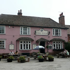
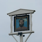
The Dog, Grundisburgh View in OS Map | View in Google Map
- Address
- The Green, Grundisburgh
- Website
- www.grundisburghdog.co.uk/
Large two bar village pub opposite the church. The public bar retains a flagstone floor whilst the lounge bar is also used as a restaurant. Guest ales on offer.
A good selection of ales upon this visit including Earl Soham and Hadleigh Breweries. Sampled Hadleigh Hellhound which was a light refreshing bitter.
The Turks Head, Hasketon View in OS Map | View in Google Map
- Address
- Low Road, Hasketon
- Website
- https://theturksheadhasketon.co.uk/
The building dates from the 15th century when it is thought it was a salt-house on the river, which was navigable at that time. The building became a pub around 1760 and was converted from one of the three barns to a farmhouse that occupied the site. The curious name of The Turks Head is thought to have come from a knight returning from the crusades. It was custom for such nobility to incorporate a Turks head into their family coat of arms. During 18th century East Anglia, it was common to adopt the landowners coast of arms as the name of the hostelry.
Unfortunately the village pub is currently closed. As of March 2014 the pub has a new owner who is looking to refurbish the pub and develop the site.
Unfortunately on this occasion we did not visit The Turks Head because we needed to keep to our timetable for the bus home. The previous year we walked a similar route and found the place to be very friendly with some excellent ale.

Features
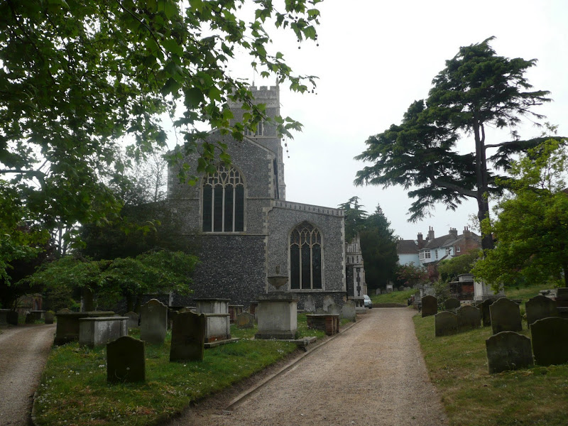
All Saints Church, Little BealingsView in OS Map | View in Google Map
A really dinky church that was built at the end of the thirteenth century, when the bishop of Norwich installed the first incumbent and rector, Giles Dodingesles in 1296. The tower was built in the 14th century with the north aisle being added in 1850/1. During Cromwell's period in the 1640s there was wilful damage inflicted to the 15th century fonts carved panels of which only two remain as well as damage to the decorated buttresses.
St Andrews Church, HasketonView in OS Map | View in Google Map
Dating from the 11th century, the distinctive round tower was added around 1300 with other additions in the 14th and 15th centuries. Like many churches around the area, this suffered during the years of the reformation when much of the colour and carvings together with the stained glass and the rood with its loft and screen were systematically destroyed. It wasn't until 1844 that restoration was begun by the Revd Thomas Maude who was responsible for the way the church appears today.
References

Gallery
Below are a selection of images taken from from the photo album for this walk. Feel free to browse through these or click on an image to view a larger version in the Gallery.


Summary of Document Changes
Last Updated: 2021-12-07
Circular Walk, Distance:Hike, Features:Churches and abbeys, full-detail, Fynn Valley Walk, OSmap:197, Riverside Walk, Suffolk


great blog but more detail and photos
ReplyDelete