Suffolk Coast Path - Snape to Felixstowe
|
Saturday 15 December 2018
|
No comments |
![]()
A 20 mile walk along the Suffolk Coast Path between Snape and Felixstowe
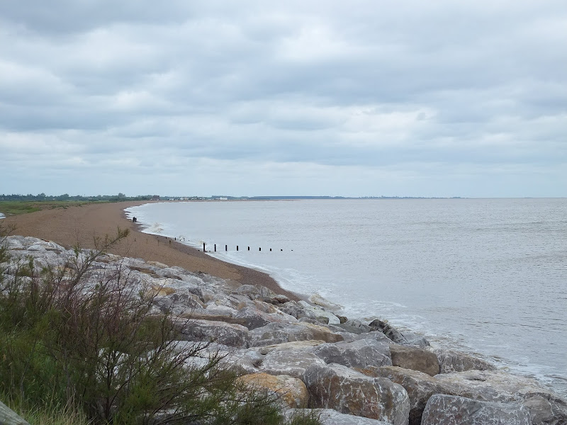
This is the most remote section of the Suffolk Coast Path and follows the Butley River down to Shingle Street and then continues along the coast to the ferry at Bawdsey. There is an eerie sense of foreboding when walking this section. The solitude. The windswept landscape. The distant silhouettes of the Orfordness Pagodas. The lonely river. One can walk virtually the entire distance without seeing a soul and the only company is the decaying remains of WWII defences and the looming martello towers from Napoleonic times.
Suffolk Coast Path - Snape to Felixstowe - Essential Information
Walk Statistics:
- Start location: Snape
- End location: Felixstowe
- Distance: miles ( km)
- Total Gain: ft ( metre)
- Total Descent: ft ( metre)
- Min Height: ft ( metre)
- Max Height: ft ( metre)
- Walk Time:
- Walk type: Linear
- Walk Grade: Easy
- Terrain: Footpaths, defence banks and tracks
Maps:
The following maps and services can assist in navigating this route. There are links to printed maps and links to downloadable GPX route data for importing into navigational software and apps.
- Ordnance Survey Explorer Map
- OS Explorer 212 - Woodbridge & Saxmundham
- GPX Route File
Transport:
Details of public transport that is required for the walk
First Group - Bus Service
- Service Details
- 64 - First Group 64 service connects Ipswich, Woodbridge, Wickham Market, Saxmundhamm, Leiston and Aldeburgh.
- Timetable
- Suffolk On Board Website
First Group - Bus Service
- Service Details
- 75/76/77 - First Group 75/76/77 bus services connecting Ipswich, Trimley and Felixstowe.
- Timetable
- Suffolk On Board Website
Ferry Service
- Service Details
- Ferry Service from Bawdsey to Felixstowe Ferry - Operates daily from May to September. Pre book during winter months. See Suffolk Ferry leaflet for further details.
- Timetable
- http://www.bawdseyferry.co.uk/Ferry.html
Route Verification Details
- Date of Walk: 2012-06-08
- Walk Time: 07:30 to 15:00
- Walkers: Griffmonster, Kat
- Weather Conditions: Blustery and overcast day
Walk Notes
I have no doubt that this is the least walked section of the Suffolk Coast Path. It is an extensive hike with little public transport apart from at either end of the walk with only one bus in each direction each weekday that passes through Snape. This means once you start the walk, you are committed to its length unless you have an accomplice to pick you up from Shingle Street or are equipped with camping gear when there is a site off route at Hollesley. Even when Bawdsey is reached, the ferry has to be running in order to get across the Deben where civilisation is reached, then its another couple of miles to get the buses into Ipswich. However, taking these restrictions into account one can catch the early Anglian bus from Leiston to Snape then return from Felixstowe via Ipswich.
The first time I walked this section was back in 2007 on a sunny summers day in August. On that occasion the only people I saw throughout the entire distance was a couple by the Martello Tower at Shingle Street. The rest of the distance was in complete solitude and despite the summer weather the morning dew was laden on the overgrown grass of the river defences which completely soaked my trousers, boots, socks. There was no good in appealing to the gods because out here in this remote part of Suffolk, no-one can hear you. As usual, I was prepared, and a fresh pair of socks got me through the remaining distance.
On this occasion, accompanied by Kat, we encountered a few more people; a couple of dog walkers in Tunstall Forest, a pallid figure huddled by the ruins of a brick building by the banks of the Butley River, glaring out across the waters. He never spoke. We never spoke. At Shingle Street we encountered several groups of teenagers with hiking packs who were heading off in different directions, undertaking some orienteering exercises. There was clearly debates going on between them about the route to take, and exactly where they were on the OS maps they were pointing definitive fingers at. Even so, what a great way to spend teenage years. Out in the wilds, learning map-reading.
A little later, a couple with a dog crossed the path and headed up a footpath to Alderton. Apart from these brief encounters, the bulk of the walk was as expected, alone with nothing but the grey clouds, brisk winds and stark landscape for company. This wind was putting white horses on the choppy old sea giving that annoying doubt that maybe the Bawdsey Ferry would not be operating in such conditions. Then we would be stuck. An additional 10-15 miles to get to public transport! Fortunately this was not the case and there were a crowd of people waiting for the ferry. On quieter occasions the ferry has to be hailed by waving the provided bat in the air.
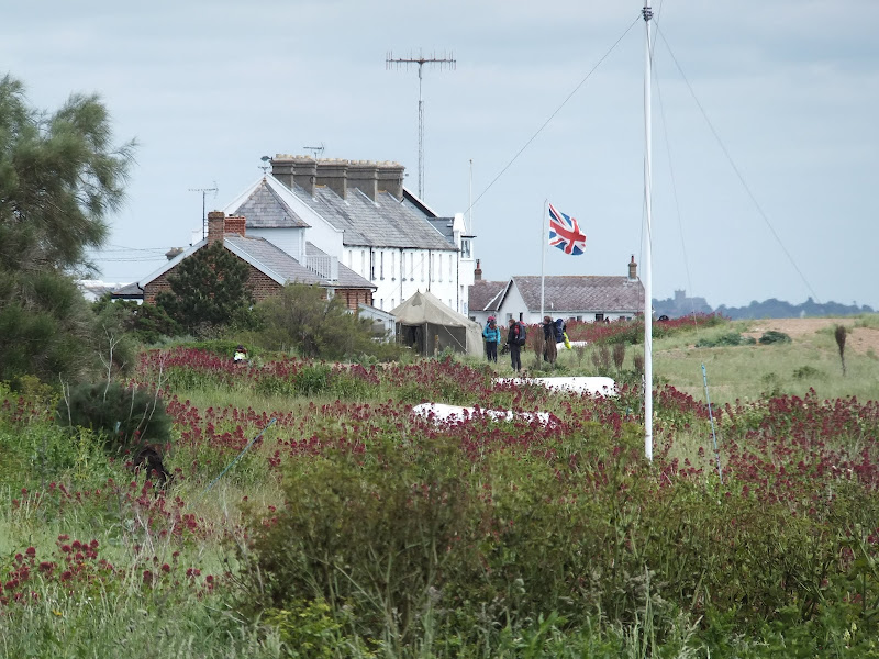
I still contest that there is an air of foreboding throughout this walk. I am not sure what generates this feeling. The solitude. The silence. The desolate marshes. The mysterious Burrow Hill looming oddly above the marshes. The concrete structures that stand ominously on Boyton Marshes. The empty hut where the Butley Ferry should depart. The discarded rowing boat on Simpson's Saltings. The omnipresent Orfordness lighthouse lurking in the distance, standing clear above the secretive concrete Pagodas that are silhouetted on the horizon. This part of the coast is full of the ghosts of conflicts of days gone by. WWII pill boxes, the Bawdsey gun battery, the Line of Martello Towers. Then amid this length of marshy desolate coastline is the beach-side hamlet of Shingle Street. A place full of untold secrets, rumours and stories unearthed over the years about what really went happened during the 1940's. The tales of burnt German bodies and the rumours of setting the sea alight to ward off a German invasion.
Despite all of this it is a part of the Suffolk Coast Path that is well worth exploring. Its desolate nature is its beauty. The solitude is its charm. The ghostly secrets are its heritage and today's fascination. And there is also Tunstall forest which is a complete contrast from the coastal section and the curious Burrow Hill which used to be an island in the Butley River estuary and some say is an ancient Saxon burial mound. There is no specific place to take a rest, so one has to make do with whatever comes along. Close to Hollesley there is a pillbox sinking into the ground and this provides an apt place to climb on its roof and sit down and gaze across the landscape. An experience and savour.
Whilst researching some of the background to this walk I came across a reference to a long line of white shells stretching across the shingle at Shingle Street. The formation was made and by a lady of the name Lida Kindersley who survived cancer and created the line as a mark of thanks. She still maintains its upkeep, fixing breaks caused by walkers, tide and weather. This is something to look out for another day, but reference to it can be found at Brianhuman's Blog
At the Bawdesy end of this route there has been some considerable erosion over the years. At the point of the old WWII gun battery the erosion has taken land right up to Rose cottage and the Martello Tower that lay just beyond East Lane. Rock defences have been placed along the cliffs in an attempt to arrest the erosion. There is no access along the beach here at any state of the tide and one has to navigate inland up East Lane to the road down to Bawdsey. There was access back to the beach along a track just past Bawdsey Hall, but this has now been prevented by more erosion and one has to walk through to Bawdsey ferry via the road.
Directions
The Suffolk Coast Path leaves the Alde estuary at Iken to head inland through Tunstall Forest and then follows the Butley River and the Ore down to Shingle Street where it follows the coast to Bawdsey. A ferry service connects Bawdsey with Felixstowe Ferry where the promenade leads into Felixstowe town.
Snape to Butley Ferry
The coast path follows the Alde estuary from the southern side of Snape Maltings. This uses boardwalks across the marshes to Iken cliff where the path heads up the hill to the road. Turn right on the road and then left along a track down to a farm. The waymarker here has fallen down into the hedgerow which can be misleading. Keep to the farm track down to the farm and follow it around to the left and beyond the reservoir where another track leads off to the right. Take this keeping alongside the woods on the right until there is a gap in the trees. Walk through the gap and continue in the same general direction on the opposite side of the trees. This keeps to the boundary of a couple of fields until a thick row of trees is encountered on the right. A waymarker points down the side of the trees, follow this all the way through to the road. Cross the road and enter Tunstall Forest. A small path leads through the trees and emerges onto a broad track through the forest. When the track bends to the right, continue straight ahead onto another footpath and keep to this in a straight line, crossing a road, until it emerges from the forest onto a track down to Chillesford. Turn right, past the Froize Inn pub and take the road on the left.Keep to this down to Butley Mill, then take the track on the left beyond the Mill. Keep to the track until it emerges onto a little road at Butley Low Corner, a small hamlet made up of a few houses. Turn left and follow the road to the end then right and onto another track. This leads down to Burrow Hill which lurks ahead. The continues directly over the hill and down the far side where a footpath leads off to the left and up onto the River banks of the Butley River where the ferry operates during holiday seasons.
Butley Ferry to Bawdsey Ferry
Follow the river banks. The Butley River soon joins the River Ore (which is called the River Alde further up the estuary). Keep to the path with the river to your left, the sea parallel to this beyond and drainage ditches to your right. This path leads all the way through to road down to Shingle Street. Either follow the road or take the river banks down to Shingle Street and continue past the beach-side houses to the Martello to the south. The path leads inland just beyond the tower, then up onto a defence bank. Keep to this all the way down to the East Lane Gun Battery. A road then leads up to Bawdsey. Keep bearing left then take a left on the road to the ferry. Just beyond Bawdsey Hall the official route crosses the fields back down to the beach and there is a strenuous walk across the shingle and around the estuary to the ferry - this is now inaccessible due to erosion with the steps down to the beach having been swept away. The alternative is to follow the road down to the ferry.
Felixstowe Ferry to Felixstowe Town
Keep to the promenade that follows the estuary round to the sea. Keep to this until the beach-side road on the top of the cliff turns inland. There is a path up to the road. Keep to the road until there is a small roundabout. Turn left and the buses into Ipswich depart from across the road. The railway station is just through the shopping area beyond the bus stop.

Pubs
The Ferryboat Inn, Felixstowe Ferry View in OS Map | View in Google Map

- Address
- The Ferryboat Inn, Felixstowe Ferry
- Website
- www.ferryboatinn.org.uk/
The site of the inn was originally a fisherman's hut for selling fish and dates back to 1043. The present building dates from the 15th Century when it was the home to the Ferry master. It became a hostelry in the 16th Century. The hamlet it sits in is presently known as Felixstowe Ferry which dates from the 19th century. Before this time is was known as plain Felixstowe and the present town that bears this name was then known as the Waltons.
The Inn offers a range of food with daily specials displayed on a blackboard. Guest ales are available.
A worthy pint of ale and beef baguette after a long walk

Features
The Shingle Street MysteryView in OS Map | View in Google Map
The first houses in Shingle Street were built in 1810 soon after the construction of the Martello Tower that stands to the south of the hamlet. In those days the mouth of the River Ore was just to the south of Shingle Street and the houses were built for the local fishermen who also acted as river pilots. Up until the second World War there was a pub at Shingle Street called the Lifeboat Inn but this was flattened by an uncharged chemical bomb devised by Porton Down after the military evacuated the village and mined the beach. It was during the war years that the Shingle Street mystery occurred. There have been many documentaries and reports about the mystery's, rumours and tales that surround Shingle Street and even today there is no conclusive evidence as what exactly occurred. Many locals testify to the events but the official line is that it didn't happen and was purely disinformation put about by the powers that be in order to keep up the British Morale after suffering the defeat at Dunkirk.
The story unfolds soon after the British allied defeat at Dunkirk in 1940 which had left British morale in tatters and left the military short of hardware which had to be abandoned during the retreat. British intelligence had caught wind of 'Operation Sea lion', a German plan to invade Britain along the South Coast. This is well known about but there was also a second German operation to invade the poorly fortified Suffolk coast, in particular targeting a six mile stretch of coastline between the mouth of the River Ore to the Harwich Harbour. British intelligence had noticed the build up of troops at Belgium and French ports and hastily sought counter measures to defend the vulnerable Suffolk coastline. Shingle Street itself was evacuated in order to mine the beach and use the buildings as target practice. But with limited resources and with the knowledge of an impending invasion the military covertly added in another line of defence. At selected parts of the East Anglian coast they lay a network of underwater piping just below the low tide line. At the sign of imminent invasion they would pump the pipelines full of fuel and then set the sea alight to prevent the enemy landing.
It was one Saturday in late August 1940 that such a threat became reality. A flotilla of German warships had already set out from Belgium and French ports headed for Britain. As they approached the Suffolk coast during the evening of that fateful Saturday, the order was given to set the sea alight. The defence was a total success by the fact that it repelled the attack as the fleet was engulfed in the inferno. At Aldeburgh there was a serviceman's dance being held at the Jubilee Hall which was cut short and the Local Defence Volunteers were put on red alert as they watched the sky being lit up in the distance accompanied by gunfire and explosions. In the aftermath many local people witnessed hundreds of burned bodies of German soldiers being washed up along the shore. Some bore witness to them being loaded onto army trucks and being carted away. Those involved were told that the operation was top secret and not to talk to anyone about it. Civilians were threatened if they if they did not keep silent on the sights they had witnessed and the whole thing was hushed up. According to the authorities nothing happened, there was no invasion, no sea set alight and no burned bodies washed up on the Suffolk beaches and any story about such was pure disinformation. This official explanation remains in place to this day but many who were involved, now in their later years, have come forward with testimonies of what they had witnessed. Maybe the full truth will never be revealed but one cannot ignore these veterans who state that they were there.
A website has been set up dedicated to the Shingle Street mystery and includes many testimonies, letters and articles from those who were involved in both the sighting of the sea ablaze and the clear up of burnt bodies in German uniform. It is an intriguing and curious mystery.
References
Boyton Marshes AFV RangeView in OS Map | View in Google Map
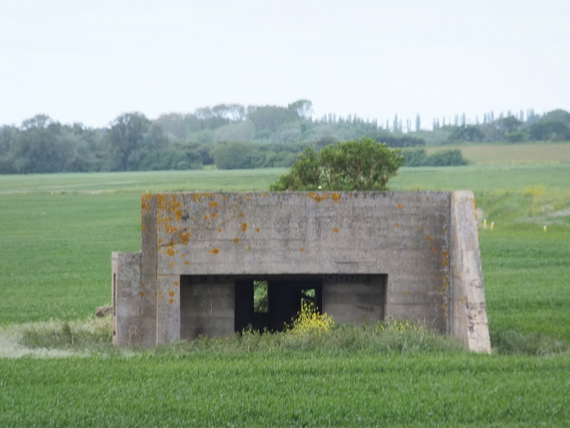
Where the Butley River meets the River Ore and heads south towards Shingle Street, on the landward side is an area known as Boyton Marshes. It was here that during WWII an Armoured Fighting Vehicle range was constructed. A triangular track was laid where tanks would tack around and fire live ammunition at tank shaped targets that were towed along a narrow gauge track built into earth banks which provided shielding. These were controlled from a series of large concrete block houses with smaller block houses controlling flip up targets for the tank machine guns.
Three of the block houses are still intact and are visible on the marshes from the Suffolk Coast Path, their curious form being completely different from the usual pill boxes that are encountered along the coast. These curious concrete structures with sloping sides almost resemble some kind of rocket launchpads and appear quite eerie amid the stark flat landscape.
Website detailing WW2 defences in SuffolkReferences
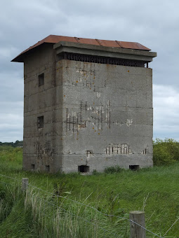
Bawdsey Gun BatteryView in OS Map | View in Google Map
At Bawdsey the coast path heads inland to navigate around the coastal erosion. At this point there are the remains of Bawdsey Gun Battery which was part of Harwich Fire Command and built in 1940. This concrete structure, partly concealed below ground, housed the magazines, watch shelters and gun stores and was connected to the guns by covered passages. There is also the remains of the distinctive Battery Observation Post. This two storey building includes a basement housed an armoury, a telephone room and a range-finder. There were also barracks, messes, ablutions and stores in a spinney at the rear of the battery. The most notable aspect of any visitor to the gun battery is the metal grill on the upper story of the observation tower which spells out the words 'Prisoner of War'
This structure forms an integral part of one of the most complete 20th century coastal batteries in existence (and 7 out of 116 Emergency Batteries), relating to the rapid enhancement of Britain's coastal defence in the early stages of the Second World War.
Gallery
Below are a selection of images taken from from the photo album for this walk. Feel free to browse through these or click on an image to view a larger version in the Gallery.


Summary of Document Changes
Last Updated: 2021-12-07
Coast Walk, Distance:Hike, Features:Folklore, Features:War Heritage, full-detail, OSmap:197, OSmap:212, Suffolk, Suffolk Coast Path


0 comments:
Post a Comment