Alternative Coast Path Route from Sheringham to Cley
|
Sunday 16 December 2018
|
1 comment |
![]()
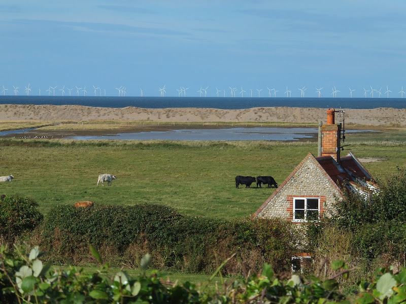
A 10 mile alternative route for the North Norfolk Coast Path between Sheringham and Cley
This walk takes diversions from the official route of the North Norfolk Coast Path via the North Norfolk Railway and the Weybourne Priory Ruins. A further alternative is then used to navigate away from the strenuous shingle walk along the coast to a more gentle amble up to the village of Salthouse and across the hills to Cley. This provides a scenic and interesting alternative to the official route of the North Norfolk Coast Path and gives some spectacular views across the marshes from the hillside between Salthouse and Cley.
Sheringham to Cley Walk - Essential Information
Walk Statistics:
- Start location: Sheringham
- End location: Cley
- Distance: miles ( km)
- Total Gain: ft ( metre)
- Total Descent: ft ( metre)
- Min Height: ft ( metre)
- Max Height: ft ( metre)
- Walk Time:
- Walk type: Linear
- Walk Grade: Easy
- Terrain:
Maps:
The following maps and services can assist in navigating this route. There are links to printed maps and links to downloadable GPX route data for importing into navigational software and apps.
- Ordnance Survey Explorer Map
- OS Explorer 251 - Norfolk Coast Central
- Ordnance Survey Explorer Map
- OS Explorer 252 - Norfolk Coast East
- GPX Route File
Accommodation:
Woodhill Park CampsiteView in OS Map | View in Google Map
- Website
- https://www.woodhill-park.com/
- Description
- Located on the clifftops at East Runton, half way between Sheringham and Cromer, this highly recommended touring site is ideal for exploring North Norfolk with public transport available to many destinations from the entrance to the site.
Transport:
Details of public transport that is required for the walk
Various Operators - Bus Service
- Service Details
- Coasthopper CH1, CH2, CH3 - Unfortunately, in recent years the highly acclaimed Coasthopper bus service has suffered from subsequent takeovers with a consequent deterioration of the service and continuing doubts upon is viability. Due to its constant changing operators, it is therefore best to use the Traveline website to determine the current timetables and services.
- Timetable
- www.traveline.info
Route Verification Details
- Date of Walk: 2012-09-16
- Walk Time: 11:00 to 16:00
- Walkers: Griffmonster, Kat
- Weather Conditions: Clear blue skies, sunshine, warm
Walk Notes
Norfolk Name Pronunciations
Before one starts out on a walk such as this it is worth noting the local pronunciations of the places that one will be passing through. Sheringham is fairly easy and not too far removed from its spelling, spoken as Shearinum. Next along the route is Weybourne which is simplified to 'Webbun', then further along the route is Salthouse which one should address as sal 'ouse (dropping the h) and finally there is Cley which is localised as Cly. Now we are ready to walk!
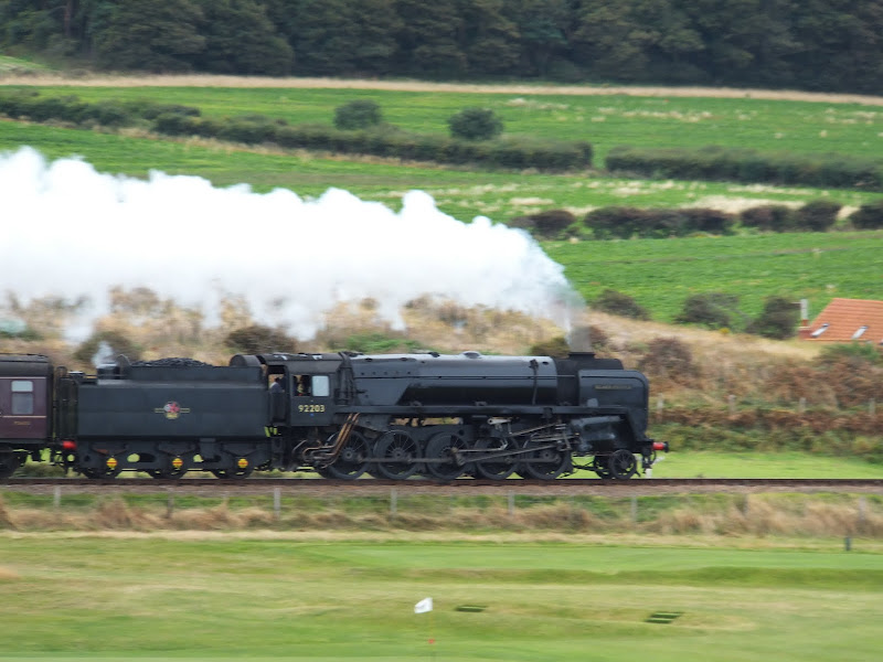
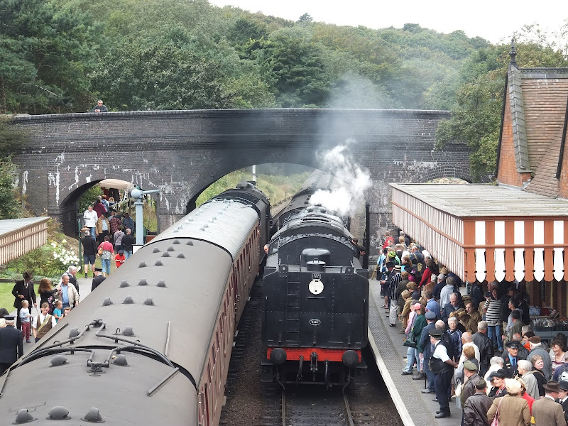
Steam Trains
The weekend had been the North Norfolk Railways 40's celebration which encouraged folk to dress in 40's attire and the Poppy Line providing an extensive steam hauled timetable throughout the two day event. The entire town of Sheringham joined in with the celebrations, and wandering through the town one was bombarded with signs of the 1940's. Old cars. Old motorbikes. Old buses. Shops decked out in 40's memorabilia. Bullet holes painted on masonry. Men dressed up in old military uniform. Ladies with gravy tinted legs. Almost compulsory was the abundant supply of Dads Army lookalikes with several examples of Captain Mainwaring and Corporal Jones parading the streets. Probably the most comical of sights was a nazi dog, a small terrier type dog with an attitude and wearing a coat emblazoned with a swastika.
The previous day we had taken in the sights around Sheringham and joined the throngs of people on Sheringham station to browse around the memorabilia. It was with this in mind that we decided to take the alternative route away from the official Coast Path and navigate up to Weybourne Station to visit their part in the 40's celebrations. This route gives some brilliant views of the railway where frequent trains could be seen in full steam hauling their load up to Weybourne. The path crosses the railway and then uses permissive paths to get up to the station and enables views of the North Norfolk Railway Engine sheds. Weybourne station did not disappoint and we spent an hour browsing around the exhibition of old cars, motorbikes and other items of mechanisation. There was spam sandwiches on offer in a makeshift marquee, an old Anderson shelter set up at the end of the platform and plenty of people adorned in 1940's costume including a policeman, soldiers, gentlemen and more Captain Mainwaring's and Corporal Jones's.
Of all the locomotives in steam throughout the weekend, the most impressive had to be the old British Rail 92203 Black Prince. This is purchased by the NNR from the artist David Shepherd who had purchased the loco from British Railways in 1967 and then restored it . It is an awesome beast with a mighty 2-10-0 wheel configuration and a fine sight to behold for both steam enthusiasts and the common layman alike. Built in 1959, it was allocated to the Merseyside area to haul heavy iron ore trains before ending its service in 1967 as British Rail phased out steam throughout the entire network. There is not a better sight of steam than to witness this huge black engine pull a train out of Weybourne station with plumes of steam issuing skywards and the sound of the valves puffing and blowing.
Weybourne station is probably most famous from the episodes of Dads Army that were filmed there in the 1970s. There is a display of old photos taken during the filming sessions on show in the waiting room. The station is located some distance from the village that bears its name. It was constructed in 1900 principally to serve the 'Weybourne Springs Hotel' which had also been built around the same period and was intended to cater for the 'upper class'. However the hotel was never successful and was demolished in 1940.
Shingle, shingle and more shingle
I have walked the Coast Path between Weybourne and Cley on numerous occasions in all manners of weather and at various times of the year. No matter when I have walked it, whether as a small circular walk or part of a long distance hike, the most enduring reflection of the expedition is the shingle. A shingle bank stretches the entire distance between Weybourne and Cley and continues beyond, all the way up to Blakeney Point. A huge mountain of shingle. A defensive barrier keeping the sea at bay from the low lying marshes although these days this is now flattened after funding to keep it in place was withdrawn. Regular breaches of the shingle occur each year, with the sea pushing the stones onto the edge of the marsh. There is no easy coastal alternative to this four mile section of shingle and one has to plod on regardless. Each step forward always seems to be accompanied by half a step back. A mile seems like 10 in the effort that needs to be exerted. No matter where one tries to walk, on the beach side, on the marsh side, there is no easy option. It is all shingle and shingle is hard wearing on the feet and legs no matter what choice of route.
With this in mind, plus the fact that storm surges can make this section inaccessible, an alternative route was investigated that was away from the shingle to make the distance a little more enjoyable. Eventually this route was put together. True, there is still a little shingle to negotiate to get past the Muckleborough Collection but from here onwards it follows an easy walking grassed track through the marshes to Salthouse from where a path leads across the hillside to Cley. This exploration proved to be an absolute revelation with some spectacular views from the hillside between Salthouse and Cley. From this high ground the view extends across the marshes, the shingle bank with extended views of the Sheringham Shoal windfarm sited out at sea. This really is well worth walking and I cannot recommend it highly enough and if you have completed the Coast Path, try it again using this alternative. You will not be disappointed
There are other things to investigate along this walk, including the Cley windmill which is now a guest-house, and the village of Salthouse. There is a fascinating website dedicated to the history of Salthouse which can be found at www.salthousehistory.co.uk/
Directions
The path diverts from the official Coast PAth route to take in Weybourne station and village and then rejoins the official route before taking another diversion up to Salthouse and across the hills to Cley.
Sheringham to Weybourne
Follow the National Trail waymarkers westwards along the coast out of Sheringham. This soon navigates up Skelding Hill and past the Coastguard Lookout Station. Keep to the path past the Golf Course and over a couple of fields until there is a footpath heading inland. This passes over the railway and down to the coast road. Cross the road and take the track down the side of Oak Wood. Keep to this until it meets a track that in an east-west orientation. Take the west route towards Weybourne, continuing to following the woodland perimeter. This eventually emerges by the side of the platform at Weybourne Station. On normal operating days access can be gained directly onto the station platform but on days of special events the gate is locked and access is over the bridge and through the main station buildings. Continue along the road from the station which leads down into Weybourne village. The road bends round to the left, then to the right and junctions with the main Coast Road opposite the church and priory ruins. Turn left, the Ship Inn pub is just round the corner and the beach road is on the right. Take this down to the beach.
Weybourne to Cley
Follow the Coast Path along the shingle. It soon heads up onto the cliff with intermittent shingle and grassed sections as it passes in front the Muckleburgh Collection. There is a fence in front of this area with some barbed wire but there is some broken fencing allowing an easier walk across the grass rather than on the shingle. At the end of this as the fence turns inland, take the track that heads into the marsh. Follow this around The Quag, bending round to the right, then right again when it junctions with another track. This track turns and then diagonally crosses the marsh and comes out onto the coast road which leads into Salthouse. By the Green, to the left of the pub there is a footpath that leads up Sarbury Hill. Take this which is also routed as The Sculpture Trail and has some magnificent views across the coast. The path eventually descends down to Snipes Marsh with the Sculpture Trail diverging to head inland. Take a right at this juncture and follow the footpath out onto the Coast Road. Cross the road and follow the broad path all the way into Cley.
Shorter Alternative
The walk can be broken down into two smaller sections between Sheringham and Weybourne, then Weybourne and Cley. The Coasthopper bus service passes through both villages to enable the walker to return to their starting location.
Pubs
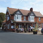
The Ship Inn, Weybourne View in OS Map | View in Google Map
- Address
- The Street, Weybourne
Traditional village pub on the main road through the village dating from the mid 1800's. During the first world war the pub became the headquarters of the Royal Sussex Regiment. Inside there is a separate restaurant area and a small snug bar at the front of the building. It is said that this bar were constructed 'during times when different classes could not bear to see each other'. Outisde there are seats on the veranda with a rear garden area. Locally sourced food is available and an ever changing selection of local Norfolk ales on offer.
A lot of pubs along the North Norfolk Coast have become the up-market trendy bars catering for the foody types who have bought up property in the area as holiday homes. The Ship Inn is different, this is more of a traditional old English village boozer that does good locally sourced food. It always has four local Norfolk ales on and that, in my book, is worth the visit on its own. On this occasion they had a couple of Elm Tree ales, a Winters ale and the usual Wherry. Elm Tree ales are always regarded highly in my estimation and with that in mind I plumped for the amusingly named Mad Maudie. It had only just been tapped and the barman warned me that it still had a slight haze to it although the chap sitting at the bar vouched for it being a worthy drink. I don't mind a slight haze and there is a difference between a haze and a cloudy beer. A cloudy beer will taste yeasty whereas a haze is caused by proteins and does not adversely affect the taste and is a symptom that tends to affect golden coloured ales. This was a typical example of a light coloured ale and the taste was well worth it, a crisp and slightly fruity summer ale that slipped down a treat. As we sat drinking two chaps returned their beer saying it was cloudy. It was not cloudy and they really did not know what they were missing. At that point the clip on the beer font was turned around. I would have made a definite request if I was having a second pint but we had walking to do!
Dun Cow, Salthouse View in OS Map | View in Google Map
- Address
- Coast Road, Salthouse
- Website
- salthouseduncow.com/
Extensive pub on the Coast road overlooking the Salthouse marshes. Originally built in the mid 1800's and recently refurbished. The pub declares that it is a pub serving good food rather than a restaurant with a bar although the trade is clearly reliant upon the food trade. The beef is supplied by the local farming whose cattle graze on the marshes. Family and dog friendly with outside garden areas overlooking the marshes There is also a secret garden at the back of the pub. Adnams and Woodfordes ales on offer.
The pub has been refurbished since our last visit and now appears to have moved upmarket. The only ales on offer were the standard bitters from Adnams and Woodfordes which was a little disappointing but better than nothing. Wherry was the choice of the day as I live just down the road from Adnams and frequently drink this. In my opinion Wherry has lost something of its powerful peppery hoppy zest that it originally boasted, something that enticed many drinkers to go out of their way to sample. This is not a comment specific to this establishment but to Wherry in general after sampling it from numerous outlets. It is still a wonderful drink as this example attested but the old character that had hops bursting out with each swig providing the real pleasure and the reminiscence of wandering around a brewery hop room has been lost to a certain extent. It is still a hoppy session bitter but not one that stands up and slaps you in the face with a fruit laden hop-bine. Its a pity as this used to be my favourite session bitter by far not so long ago. As for the pub, we found the secret garden which was a small discretely secluded garden with a sculpture and fruit trees which no-one else had managed to discover on this occasion. Secret to all but us!

Features
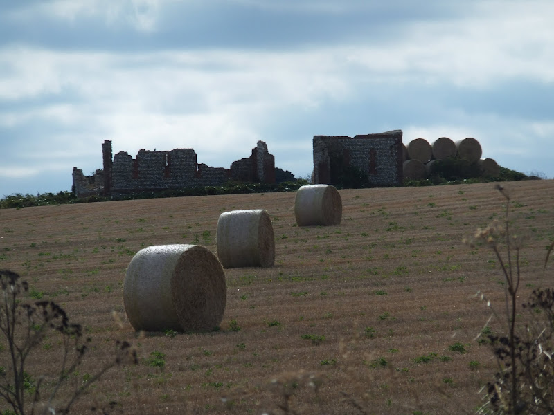
Weybourne PrioryView in OS Map | View in Google Map
The priory was founded as a house of Augustinian Canons by Sir Ralph Meyngaryn at the end of the 12th century. It was endowed with a parish church which was converted into a monastery. This lasted through to the middle-ages when the present church was built. The ruins that stand aside the church date from the 13th to the 15th century though they also incorporate the earlier Saxon cruciform church of the 11th century.
The Weybourne SmugglerView in OS Map | View in Google Map
It is said that at dusk on days of a full moon if you dare to venture down to the shore at Weybourne a whistling can be heard on the night air. The whistling evades all attempts to discover its source but locals will readily tell the visitor that it is the ghostly call of the old smuggler John Smythe. Like the majority of the East Anglian coastline during the 18th century Weybourne was frequented by smugglers landing their illicit cargo's to be whisked away into waiting villagers homes. With high taxation of such items as tea, salt and spirits the locals turned a blind eye to the trade and would often collude with the smugglers to hide their booty and put the Preventive Men, the Government Customs force, off their scent. On one particular night John Smythe was with a group of smugglers who landed on Weybourne Beach to offload their illicit cargo. The group of men were to take the goods up to the village to stow away but John also had another rendez-vous with the daughter of the landlord of the local inn, with whom he was having an affair.
As the exercise was in progress the call went up that the Preventive Men were on their way and so the smugglers swiftly returned to their boat to make a getaway. They waited awhile for their partner John Smythe but he did not show and thinking he had been caught they cast off to the calm waters. John was not caught, just late after being curtailed by his secretive meetings and when he got down to the shore, seeing no boat was around and the telltales signs in the shingle that they had left, he began whistling to attract their attention without alerting the Preventive Men. There was no response to his calls and knowing that he would be captured if he returned he started to wade out into the murky waters in a hope that his companions were not too far out. Unfortunately he could not swim and soon found himself in difficulty. There was no-one to come to his aid and with the cold waters he soon succumbed and drowned.
Since that day it is said that his whistles can still be heard as he tries to attract attention. No-one has caught sight of the source although one unsuspecting witness to the sound swears they caught sight of a shadowy silhouette on the shore.
RAF WeybourneView in OS Map | View in Google Map
The North Norfolk Coast Path passes in front of the grounds of the Muckleburgh Collection, a private collection of WWII hardware that is sited on the former Weybourne Airfield. The location is fenced off with barbed wire and the desolate area is scattered with old pill boxes, gun emplacements, anonymous buildings and masts which casts a somewhat imposing appearance about the area. Accompanying this sight is a regular high pitch electronic sound that issues out across the beach at a frequency of approximately each minute.
This area has always been of significant military importance. A sixteenth century adage states 'He who would Old England win must at Weybourne Hope begin' which reflects its importance as a deep shore water landing place. Maps from the 16th century depict a fort and other defencive fortifications along this part of the coast.
During the first world war the area was deployed with pill-boxes, gun emplacements and trenches as well as the billeting of troops.
From 1935 up until 1958 the area became a summer training camp for the Anti Aircraft Training Division of the Territorial Army and was designated RAF Weybourne. The Division employed a De Havilland DH-82B Queen Bee target drone aircraft, a radio-controlled target tug version of the Tiger Moth II, as part of their training equipment.
In 1986 part of the area was taken over by the Muckleburgh collection to house their museum of military artifacts. More recently the area has been used to locate radar which was moved from RAF Trimingham in 1996 as part of the United Kingdom Air Defence Ground Environment Radar System and controlled from an underground control centre located at RAF Neatishead.
The buildings that can be seen on the Salthouse side of the area belong to the met office and The Weybourne Atmospheric Observatory, part of the University of East Anglia (UEA) which conducts fundamental research and background monitoring and has been the focus of many international experiments designed to look into the chemistry of the free troposphere and the planetary boundary layer.
Gallery
Below are a selection of images taken from from the photo album for this walk. Feel free to browse through these or click on an image to view a larger version in the Gallery.


Summary of Document Changes
Last Updated: 2021-12-07
Coast Walk, Distance:Medium, Features:Churches and abbeys, Features:Folklore, full-detail, Norfolk, Norfolk Coast Path, OSmap:251, OSmap:252, Railway Walk


I am emailing from a leading advertising agency based in London.
ReplyDeleteI am getting in touch with you as I am looking for quality websites such as your griffmonster-walks.blogspot.com, to place some adverts on your website and would like to know if this is something which would be of interest to you?
The placement of our adverts are contextually matched to the content on the page, therefore relevant.
Do let me know if you are interested to discuss any partnerships with us as we feel the positioning of your website will have strong benefits for both parties.
Please email me back with your thoughts or questions.