Wherrymans Way - Norwich to Thurton
|
Saturday 29 December 2018
|
No comments |
![]()
A 12.5 mile walk along Norfolk's Wherryman's Way
This is a delightful riverside walk following the River Yare out of Norwich and through to Rockland St Mary. Public transport can link the start and end by navigating down quiet country lanes to Thurton. Whitlingham Country Park provides an easy route to start and there's refreshment stops at Woods End and the Ferry Inn at Surlingham.
A Walk along the Wherryman's Way - Norwich to Thurton - Essential Information
Walk Statistics:
Maps:
The following maps and services can assist in navigating this route. There are links to printed maps and links to downloadable GPX route data for importing into navigational software and apps.
- Ordnance Survey Explorer Map
- OS Explorer OL40 - The Broads
- GPX Route File
Transport:
Details of public transport that is required for the walk
First Group - Bus Service
- Service Details
- X2 - First Group X2 service Lowestoft to Norwich via Beccles and Loddon
- Timetable
- First Group (Norfolk and Suffolk) Website
Border Bus - Bus Service
- Service Details
- 146 - Border Bus Service 146 from Norwich to Southwold via Beccles
- Timetable
- Border Bus
Route Verification Details
- Date of Walk: 2013-04-13
- Walk Time: 10:30 to 15:30
- Walkers: Griffmonster, Kat
- Weather Conditions: Bright sunny spring day with cloud moving in from the west as the day wore on
Walk Notes
The Wherrymans Way is one long distance path linking Norwich with Great Yarmouth following the course of the River Yare. From Norwich to Loddon the route is within walking proximity to the A146 Norwich to Beccles trunk road where both the Anglian and First Group buses operate a frequent service between Lowestoft, Beccles and Norwich. To walk the full distance from Norwich to Loddon, though not impossible, is a lengthy hike and as such breaking this down into two day walks makes the experience much more of a leisurely and enjoyable exploration. Thurton is approximately a half way point to break the walk and only a couple of miles away from the official path along quiet country lanes.
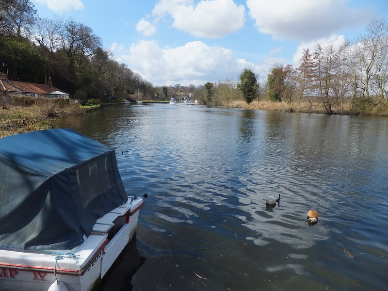
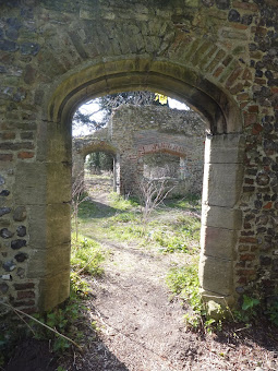
Once out of the hustle and bustle of Norwich, Whitlingham Country Park makes a most peaceful way to start the main trail. It wasn't until reaching the country park that we saw the first Wherrymans Way waymarker outside of Norwich, and, as such, reinforced my decision to always accompany walks with the required OS maps to clear up any doubt or ambiguity over the route. The walk along the side of Whitlingham broads was such a pleasurable experience. Clear blue skies reflecting in the peaceful waters. Tame ducks and swans presenting both entertainment and photographic opportunities. A local model yacht club controlling their craft around a marked course with radio control units from the shore. These were serious model buffs. The ruins of Trowse Newton Hall were a sight worth exploring. There is also a comical sculpture of a dude with a surfboard which is part of the Water-based Sculpture Trail. This trail features a series of sculptures located at key mooring points throughout the Southern Broads Area which was commissioned by South Norfolk Council.
The path leaves Whitlingham Broads to navigate over the hill and rejoin the river Yare at Woods End. Yes hill. A Norfolk hill. A lot of people have this stereotypical view of Norfolk being flat. This is far from the truth. Climb this hill to see for yourself and witness the views across to Postwick. From Woods End the path becomes a pleasurable riverside walk through to the Ferry Inn before it once again heads away from the river to Rockland Staithe.
We visited two pubs on this occasion, The newly opened and renamed Waters Edge, formerly the Woods End, plus the Ferry Inn at Surlingham. The Coldham Hall pub was purposely omitted as this will be included in a future circular walk around the Surlingham area and gives us that enticement to return. Unfortunately the New Inn at Rockland had closed down although I believe this has since reopened. Unfortunately so many pubs are struggling to keep afloat these days. This is such a sad indictment of our economic times plus the continual negative government advice about drinking. We got speaking with the barman at the Ferry Inn who told us he was merely helping out to keep the pub alive. This really is a proper old broads pub and it is amazing that despite the popularity on this Saturday lunchtime/afternoon, the business is still struggling. I really do hope that the tide eventually turns and something is done to assist pubs in general. They are part of our British heritage.
The walk towards Rockland St Mary heads up across the farmland. It was along this section we met a bearded man in a shabby jacket. Not an old chap but certainly no spring chicken. He steadily walked towards us and before we passed he stopped and offered a friendly hello in a broad Norfolk accent, then asked where we were heading, 'Rockland no doubt' he surmised. I added 'and onto Thurton' His eyes opened a little wider. 'Thurton' he emphasized, a little impressed but trying not to let it show. He looked up at the sky. The blue skies that had been so glorious during most of the day were making way for a grey covering of cloud obscuring the sun and with some of the darker cloud looking decidedly threatening. He looked back to me and gave a little friendly advice. 'Better hurry boy, be rain at 5' he advised in the slow Norfolk drool. 'I best let you get on your way' he bid a final word before traipsing onwards. I gave another inspection of the sky. It was three o'clock but the clouds were beginning to look increasingly rain-bearing. The previous evenings forecast had indeed predicted rain but they had said it would get to Norfolk until the evening. We had to make tracks.
The country lanes through to Thurton were easy walking, and apart from the initial lane out of Rockland, they were very quiet. But having said that, we only met half a dozen cars on this lane. Thurton was reached just before 4pm and we just missed the X2 bus back to Beccles where we had parked the car earlier that day. This didn't matter as the service is frequent and it wasn't long until the next bus arrived and there was a wooden bus shelter in case the rain started. The clouds were getting heavier, drawing in from the west.
The bus stops by the Beccles Quay and it is just a short walk to the car park. As we headed out of Beccles towards home on the A145 spots of rain started hitting the windscreen, not a downpour but obviously the prelude to an evening of persistent rain. I looked down at the dashboard clock. I kid you not, the time was 5pm just like the old Norfolk man had said. Spot on the dot. 5pm. He could not have been any more accurate. Don't listen to the weather forecasts, the old boys of the country know better!

Directions
The route follows the Wherrymans Way markers. These can be difficult to find at the start of the walk around Trowse so an OS map is essential. The walk from Rockland St Mary to Thurton requires following country lanes.
From the train station at Norwich follow the Wherrymans Way markers along the riverbank up to Carrow Bridge. Continue along King Street, then bear left onto Bracondale continuing straight over at the roundabout, over the railway and into Trowse. Turn left by the church into Whitlingham Lane and follow the road for half a mile until there is a track down to the Whitlingham Little Broad. The path follows alongside the Little Broad, then the Great Broad through Whitlingham Country Park. Eventually the path rejoins the lane which continues under the A47. Just beyond the underpass turn left and follow the track past the sewage farm continuing straight onto a footpath where the road bends to the right. Good views of the surrounding area can be had from the top of the hill before the path descends down to the lane that leads to Woods End, the Waters Edge pub and the riverside once again.
Continue alongside the river using the footpath at the edge of Bramerton Common. This does navigate away from the river briefly to get around an impressive large house but soon returns to the riverside. Just before The Ferry Boat Inn at Surlingham the waymarkers point along a path heading away from the river. This can be taken although the pub can be reached by continuing along the riverside path.
Head away from the pub up the road, bearing left at the forked junction. The Coldham Hall pub can be reached by taking a footpath on the left that is marked as the Wherrymans Way. This returns about 200yards up the road, but the walk to the pub and back is getting on for a mile. Continue along the road which turns to a track alongside Surlingham Wood, then becomes a footpath which navigates across the fields to the road at Rockland St Mary. Turn left and follow the road down to the Staithe. The Wherrymans Way continues down the far side of the Staithe and this is where we leave it to head for Thurton.
Keep on the road at the Staithe and turn right at the first junction. Follow this country lane as it zig zags past Burtons farm and Claxton Church. Continue straight ahead at the junction and the lane leads down into Thurton. The bus stop is located on the main road, left of the junction for Beccles, right of the junction for Norwich.
Pubs
The Waters Edge, Bramerton View in OS Map | View in Google Map

- Address
- Woods End, Bramerton
- Website
- https://watersedgewoodsend.co.uk/
There has been a pub on this site since before 1700. During Victorian times the Inn included tea rooms and a garden and became popular with pleasure craft daytrippers from Norwich. The pub was known as Woods End up until 2013 when, after a period of closure, it was revamped and reopened under the moniker of The Waters Edge with the intention of catering for both the boating fraternity and walkers alike. There is the intention to serve breakfasts from 8am.
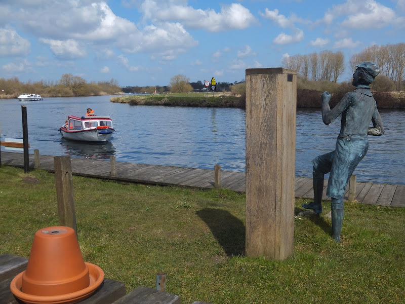
In front of the pub, on the river bank is a statue of William Cullum, popularly known as Billy Bluelight. During the 1920s and 1930s he would challenge boat trippers to a race along the river bank and was famed for his claim of 'My name is Billy Bluelight, my age is 45, I hope to get to Carrow Bridge before the boat arrive'. It is said that his age remained at 45 for many years.
A range of home cooked food is on offer together with ales from Greene King and Woodfordes breweries.
The pub is in an ideal position and it was great to sit alongside the river supping a pint of Woodfordes Wherry whilst watching the pleasure boats sail up and down the river. It is true that the pub has been modernized into the typical modern minimalist plain walled decoration but at least this is keeping the hostelry open in these times when the humble British pub is suffering from so many closures. The hosts were friendly and the beer was very good so I have no complaints there, and judging by the many cruisers that were mooring up during our short stay, hopefully this custom will keep the pub open for years to come.
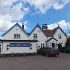
The Ferry House Inn, Surlingham View in OS Map | View in Google Map
- Address
- Ferry Road, Surlingham
There are records of a pub being here in 1725 when it marked the embarkation point for the ferry across the Yare to Postwick. The ferry ceased to operate in 1939 following a collision with a coaster. During the 19th century the pub was used as a coal depot and as a court house for the collection of tithes.
Today the pub is a thriving traditional riverside inn and values itself on providing traditional home cooked food and a selection of local Norfolk ales from breweries such as Wolf and Humpty Dumpty. The pub is open each day from 11am with food being served until closing time. There are moorings for boats, walkers are made welcome, the pub is both dog and children friendly.
A traditional British pub that is well worth visiting. A selection of ales including Humpty Dumpty's Little Sharpie which was at its very best. A handsome cheese baguette although there was more tempting and substantial food also on offer. Friendly staff and atmosphere. It was good to see the pub full of custom and a lot of jovial banter was had between customers and staff.

Features
Whitlingham Country ParkView in OS Map | View in Google Map
Whitlingham Country Park is set around Whitlingham Great and Little Broad. These are modern broads created from gravel extraction during the 1990's, the product of which has been used in several major projects in Norwich including the Castle Mall and Chapelfield shopping centres. Today an Outdoor Education Centre has been erected on the southern bank of the Great Broad.
Within the limits of the country park can be found the ruins of Trowse Newton Hall, which was built as the country retreat of the Priors of Norwich Cathedral and its lodgers also included King Edward III in 1335. The hall was demolished in late 19th century although there are some remaining ruins still standing among the trees. Further east on th edge of the path is the location of the parish church of Whitlingham dedicated to St Andrew. It is thought that this was round towered church and was already a ruin by the year 1630, becoming a landmark sitting on a high precipice overlooking the river. The ruin was embellished in the 19th century with the parapets being rebuilt and new window tracery inserted. The tower collapsed in 1940 and today the little that remains of the ruin is hidden by undergrowth and trees.
Gallery
Below are a selection of images taken from from the photo album for this walk. Feel free to browse through these or click on an image to view a larger version in the Gallery.


Summary of Document Changes
Last Updated: 2021-12-12
Cross-Norfolk Trail, Distance:long, Features:Nature Reserve, full-detail, Norfolk, Norfolk Broads Walk, OSmap:OL40, Riverside Walk, Wherrymans Way


0 comments:
Post a Comment