Gipping Valley River Path - Stowmarket to Needham Market
|
Sunday 9 December 2018
|
2 comments |
![]()
An easy 5 mile walk following Suffolk's River Gipping between Stowmarket and Needham Market
The river Gipping forms the source to the mighty Orwell River. At Stowmarket it is no more than a babbling stream that winds its way through the Suffolk countryside. The path keeps to the riverside throughout with no difficult obstacles other than styles, making a pleasant stroll between these two places. With some fantastic pubs at either end it makes a good little pub crawl.
Stowmarket to Needham Market Riverside Walk - Essential Information
Walk Statistics:
- Start location: Stowmarket
- End location: Needham Market
- Distance: miles ( km)
- Total Gain: ft ( metre)
- Total Descent: ft ( metre)
- Min Height: ft ( metre)
- Max Height: ft ( metre)
- Walk Time:
- Walk type: Linear
- Walk Grade: Easy river side path
- Terrain: Footpaths throughout
Maps:
The following maps and services can assist in navigating this route. There are links to printed maps and links to downloadable GPX route data for importing into navigational software and apps.
- Ordnance Survey Explorer Map
- OS Explorer 211 - Bury St Edmunds & Stowmarket
- GPX Route File
Transport:
Details of public transport that is required for the walk
First Group - Bus Service
- Service Details
- 88/88A/89 - First Group 88/88A/89 bus services connecting Ipswich, Needham Market and Stowmarket.
- Timetable
- First Group Suffolk and Norfolk Website
Route Verification Details
- Date of Walk: 2013-09-07
- Walk Time: 11:30 to 15:00
- Walkers: Griffmonster, Kat
- Weather Conditions: Sunny day with fluffy clouds, becoming more overcast as the day went on
Walk Notes
A Great Little Pub Crawl
The Gipping Valley River Path is only 17 miles in total and easily achievable as a day walk. However, this short section is a good walk as a pub crawl for any ale enthusiast with two worthy pubs to visit at the start of the walk in Stowmarket and another at the end in Needham Market. The Royal William in Stowmarket is the most unusual location for such a fine example of a pub. It is not easy to find, hidden away in the back streets but judging by the number of ales it regularly has on offer it must have a very extensive customer base. In times where the traditional English pub is becoming a rarer establishment this particular local is showing the way forward. Offering good crisp clean ale in prime condition is something that cannot be replicated at home and something worth going out of ones way to find. It is obviously working here as even on this lunchtime the pub is full of folk enjoying their beer and plenty of conversation. I have also had other reports from visitors to the pub which state the same. Good ale and always lively and busy. This just goes to show, and something I have always stated, that it doesn't take TV screens and fruit machines to entice custom, just good beer.
The Trail
The Gipping Valley River Path is picked up close to the Royal William pub and starts with a landscaped riverside path alongside blocks of new buildings. Beyond this welcoming beginning, the route soon encounters a modern bridge that carries the B1115 road, part of a recent Stowmarket relief road construction. The concrete sides carry a series of murals depicting local life, although I can find out little about why or who or what these murals were created for. It still looks like a modern concrete construction but at least the monochromatic murals give an item of interest rather than the usual un-inventive daubs of graffiti that are often scrawled upon these structures.
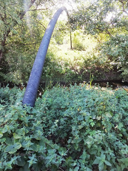
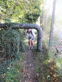
The bridge is soon left behind and is lost from sight as the path turns into a riverside track negotiating its way through Stowmarket's industrial areas, roughly following the railway track which lurks behind the ageing brick buildings, wasteland and tarmacadam covered ground. It isn't the most picturesque place to be walking through, the murky path confined to the river edge with wire fences to guard the hallowed industry and confine the humble walker to the legislated footpath. The river banks are overgrown but the path readily cleared and accessible. Industrial looking pipes bridge the river including one that sweeps a huge arc across its width. This would be something of a noteworthy feature but for its dreary drab industrial colour. Another pipe passes over the path to bend down and disappear into the ground next to a woven wire fence. The walker is forced to pass underneath the pipe. The headroom would suit a child, a dwarf, a midget, a limbo dancer, a group of orderly traipsing gnomes, a tortoise or a troop of acrobatic ants but not an average size person. This means having to duck down to get under it. An apt phrase as a duck would comfortably fit under this obstacle. A man with a stout rucksack, no chance, he is reduced to a crawl on all fours. You have to expect such obstacles on footpaths. This is in no way a complaint. Just an observation. Such obstacles add interest and give a memory of that particular section though it has to be said that the pipe with its light grey wound insulation makes it look somewhat toxic within the environment around it.
There's another concrete bridge, this time carrying the A1120 road to Yoxford. There are more overgrown banks. More wire fences guarding industrial premises. At times it does seem that one is walking through the backsides of a dirty old city, but it is notable that there is the distinct lack of abandoned shopping trolleys lying forlorn in the river waters. There are no dumped fridges tossed off the sides of bridges. There's no old tyres harbouring captured vegetation. There is not even the discarded lonesome bicycle frame which usually graces an urbanised watercourse. This is all tell-tale evidence that Stowmarket is not an urban monstrosity but a small Suffolk Town with a small industrial area built up around the railway.
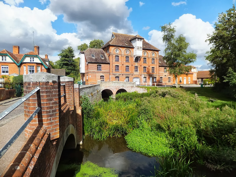
Eventually the path reaches Muntons maltings, identifiable by the huge grain silos. This is where much of East Anglian grown barley comes to be malted ready for brewing beer by the regions many and varied breweries. The complex includes its own 3 million hectolitre brewhouse which produces malt extracts and home brew kits for the domestic market. The whole site is fronted by a well groomed piece of parkland that the footpath passes through and which forms the entrance to the maltings. A lush green lawn carpets the ground and tall leafy trees including sycamore and weeping willow offer delightful shade with park benches overlooking these pleasant surroundings. A road leads around the perimeter of the park and the footpath crosses this and descends a flight of wooden steps, sadly not in the best of conditions, to continue along the riverside.
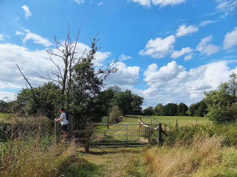
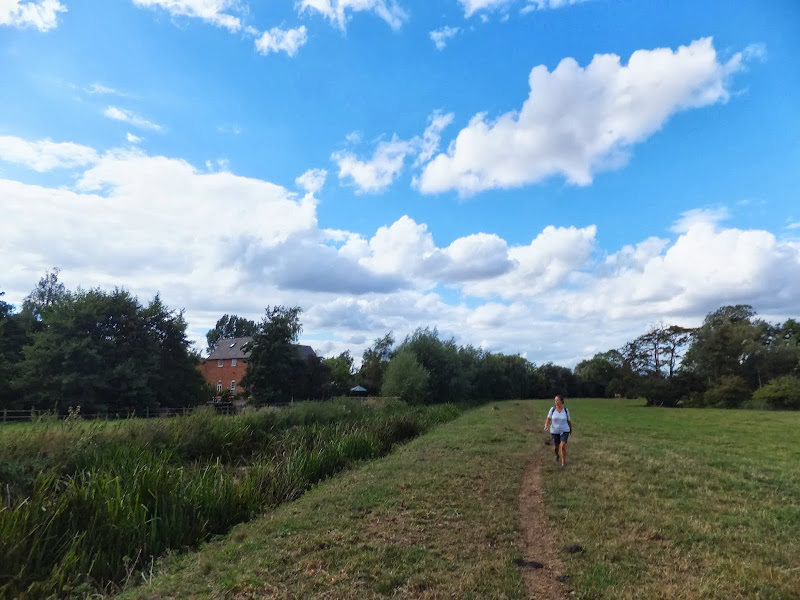
The river bends around and goes under the railway and then out into open countryside. Gently sloping fields, filled with crops, adorn the valley side. The lower fields along the riverside are meadows where cattle graze. At one point there is a shallow bank that forms a waterhole for a herd of cows. Badley Mill farm can be seen across the river, the site of the former water mill whose buildings can just be made out. The river then twists through a wooded area before it emerges on the final stretch to Hawks Mill. At this point the Gipping Valley River Path continues on towards Needham lakes, but on this particular walk we head across the road bridge up towards the village of Needham Market. This route provides some glorious views of the renovated mill and millpond, a sight that cannot be seen from the footpath and certainly a photographic opportunity. The narrow road then leads under the railway and there is a series of steps up to a high causeway where houses line the road all the way up to the high street.
The end of the walk is at the Rampant Horse pub. A fine hostelry that serves ale and food. A reward for the effort. And the bus stop that serves Stowmarket and Ipswich is just around the corner. Opposite is a cottage with a decorated front wall. The bus stop has a shelter where a plaque display the royal seal for Queen Victoria with the inscription of 'This tablet was erected in commemoration of the Queen's long reign' and dated 1897. A fitting end to a pleasant walk and a glorious pub crawl.
Directions
A riverside walk along the Gipping Valley.
The Gipping Valley River Path starts on Stowupland Street. The route to this location from the bus stop opposite the Wetherspoons Willow Tree pub is through Morrison's supermarket car park which is directly behind the pub, taking the main exit which then leads out onto Milton Road. Turn Right and then left at the junction with the A1308 Gipping Way. At the crossroads with the B1115 turn right towards the railway station. The Kings Arms pub is on the right as the road bends around to the left. Continue around the bend and take Stowupland Street which is on the left. The path starts on the left where the road crosses the river. The Royal William pub is found by carrying on along Stowupland street and taking the second road on the right, Union Street East. The pub is a hundred yards down this road on the right.
The Gipping Valley River Path follows the riverside and is marked out by the well trodden path. There are a few obstacles such as a low headroom pipe and broken steps by Muntons but all of these are relatively easy to negotiate. Keep to the same side of the river throughout the walk. The path eventually leaves Stowmarket at Muntons Maltings from where it goes under the railway and heads out into countryside following the river through the meadows. Eventually it meanders through some woodland before emerging on the final section to Hawks Mill. This is easy to notice by the weir and sluice. When the path crosses the road, turn right and follow the lane past the mill and under the railway. Immediately after the railway bridge there are steps up to an elevated causeway that leads to the High Street of Needham Market. Turn left and follow the road through the village. The Rampant Horse is on the left at the junction with Coddenham Road. The bus stop is just beyond this junction, with Ipswich bound buses on the pub side of the road, and Stowmarket bound buses on the opposite side.

Pubs
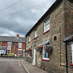
Kings Arms, Stowmarket View in OS Map | View in Google Map
- Address
- Prentice Road, Stowmarket
This prominent building stands opposite the towns railway station providing a well placed watering hole for travellers. Publican records show that this was a pub as early as the mid 19th century. During its formative years the building was owned by the Cobbold brewery until it finally closed its doors as a pub in 1958. It was during this period, specifically the early 20th century, when the pub attained the localised name of 'The Two Sisters' in honour of the two sisters, Mabel Harriett Southgate and Jessie Hilda Taylor nee Beaumont, who were the landladies during that period.
Fortunately in December 2009 the building was reopened as a freehouse providing an outlet for many East Anglian breweries with five ales regularly on offer along its curved bar. The pub has a friendly and welcoming atmosphere and has also hosted several beer festivals. Well worth popping in for a drink before ones train arrives.
On 31st October 2020 the pub closed for the final time and is now waiting for a planning application decision.
This brick building standing alone virtually in the station yard looks rather unassuming from outside. However, on entering the premises one is cheerfully greeted by the locals who are gathered around the bar. The ale was good, and conversation freely flowed between us, the locals and another couple who were on the Woodfordes Ale Trail. This really is what a good old fashioned local should be like. A fine pub and well worth popping in for a pint and a chat.
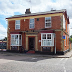
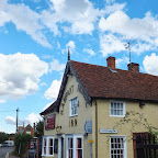
Royal William, Stowmarket View in OS Map | View in Google Map
- Address
- Union St East, Stowmarket
- Website
- https://www.theroyalwilliam.co.uk
The building can be traced back to being a pub in the mid 19th century but it was only given a full licence in 1962. The pub is a completely unspoilt back street tavern kept alive by locals. There is nothing fancy about this pub and it is well worth seeking out. Very friendly and the large selection of ale is served on gravity from a small temperature controlled rom behind the bar or from a new gravity servery located in an outside building.
The most worthy pubs to visit always seem to be the most unassuming back street enterprises. This certainly is true for the Royal Billy. Tucked away in the back streets, which needed directions from the locals at the Kings Arms to find it, it is well worth seeking out. The ale list is impressive, displayed on a board and including brews from Brentwood, Cottage, Nethergate, Wolf, Green Jack, Oakham and Woodfordes. There are a few hand pumps but the majority are served straight from the barrel in a back room. A fine old alehouse and well worth seeking out.
Rampant Horse, Needham Market View in OS Map | View in Google Map
- Address
- Coddenham Road, Needham Market
- Website
- https://www.facebook.com/TheRampantHorseNeedham
This timber framed building can trace its use as a pub back to 1544 which entitles it to the claim of the oldest pub in Needham Market. During that year it was known simply as Chequer and has since had a vareity of names down the centuries including The Cross House in 1590, The Kings Arms in 1618, The Ram in 1750, The White Horse in 1775, the Fleece in 1804 and finally the present moniker of The Rampant Horse being adopted in 1830.
At the rear there are the former stables which date from from 1500 and the land beyond, which is now occupied by the railway station, all the way down to the river was formerly designated as 'camping land'. This name is derived from a medieval game known as Campball which is said to be the precursor of modern day football and involved any number of players attempting to get a ball by any means possible to the other side of the game area. There were few rules and the event could degenerate into a mass brawl with players obtaining numerous injuries and even death. In one match on Diss Common during the nineteenth century it was recorded that the game became so brutal that nine men were killed or died of their injuries.
In 2012 the pub was purchased by the Calvors Brewery of Coddenham Green who completely refurbshed the bar to present a welcoming and friendly pub that prides itself on good food, real ale and, of course, their own locally brewed series of real lagers.
An historic pub and although not the range of ales of the previous two hostelries, they nonetheless had three worthy ales. A handsome baguette was worth waiting for. Lovely old pub full of history.
Features
Badley MillView in OS Map | View in Google Map
Badley Mill is located on the River Gipping just outside of Stowmarket. Although no longer a mill, the mill house is still standing and dates from the seventeenth century although the Domesday survey mentions the manor of ‘Badeleia', as Badley was then known, included 'half a mill' which suggests the site had a mill as far back as the 11th century. The intriguing mention of 'half a mill' maybe down to the fact that the mill straddled the river with half of it in the manor of Creeting.
The Poley family owned the manor from the 16th century, inheriting it through marriage. During this period the mill was known as Vaysies (sometimes Vesseys) Mill and included a 63 acre farm, part of which was in Creeting Parish which concurs with the half-a-mill theory. Eventually the entire estate including the mil passed into the hands of Second Earl of Ashburnham where it remained until being sold to a Mr Freshwater in 1917 and he continued grinding corn up until the late 1920's when the operation ceased due to a broken water wheel. The cause, as judged by a court, was put down to the polluting chemicals that a silk processing company, named as Silkworks, was discharging into the river upstream. It was said that these chemicals had caused the wood to rot and the mill-owner was awarded £2,600 in compensation. Unfortunately he never received his monies as the company went into liquidation forcing Mr Freshwater to make a living solely from the farm that went with the mill.
On the death of Mr Freshwater the mill was sold to a Mr. Sunshine but he neglected its upkeep resulting in the building getting into a bad state of repair. It was eventually bought and restored by Avril and Tony Hunt who ran it as a guest-house. It has since reverted to a private accommodation but still bears the name of Mill House.
References
Hawks MillView in OS Map | View in Google Map
There is mention of a mill at Needham Lock in the Domesday book of the 11th century. The building that currently occupies the site, however, dates from 1884 when it was constructed as a working water mill. The building is now in private residential use but still retains a working Armfield water turbine although the rest of the machinery has been removed.
Local FolkloreView in OS Map | View in Google Map
Half way down the high street between the Hawks Mill Lane and the Rampant Horse pub is a lane on the right hand side. The road is clearly named as the Causeway although it is commonly believed that this is a corruption of an old name 'Corpse Way'. The course of the lane originally lead all the way through to Barking Church, as this was the way that the burial parties.
During the 1980's the Corpse Way was the setting for some ghostly sightings. One witness passed by a figure dressed in an old Victorian uniform. The figure appeared real enough but on turning to take a second look the figure had vanished. Other witnesses have stated seeing a lady dressed in blue waling ahead of them who then vanishes as they turn the corner of the lane.
Another legend of Needham Market tells of the old pub called the Waggon and Horses which was sited just before the junction with Coddenham Road where the Rampant Horse is located. The building is still there although it is now two private houses one became known as The Waggon and the other The Horses. In the middle, on the upper story are the old iron fittings that held the pub sign. The building dates from the 15th century and it finally closed down as a pub in 1970. It is unknown whether the residents have experienced the ghostly old woman that was said to haunt the old pub.
Going back towards Stowmarket, at the hamlet of Badley was where a man drowned in the river Gipping in May 1911. The corpse that Jack Mayhew fished out could not be identified. An unknown body could not be buried to the front of a church, so Mr Mayhew carried the corpse in his wheelbarrow around to the north side of the Badley church where he placed it in an unmarked grave. A small mound is still visible to this day.
References
Gallery
Below are a selection of images taken from from the photo album for this walk. Feel free to browse through these or click on an image to view a larger version in the Gallery.


Summary of Document Changes
Last Updated: 2023-09-25
Distance:Medium, Features:Folklore, Features:Mills, full-detail, Gipping Valley River Path, OSmap:211, Pub Crawl, Riverside Walk, Suffolk


As usual, a superb write up. Thanks. It's a walk I've bee planning to redo for some time, but I've never quite got around to it.
ReplyDeleteI'm surprised you haven't mentioned that the walk roughly follows the old towpath of the Stowmarket Navigation - some of the locks can still be seen in places. The existing river was canalised via a series of locks and dredging, rather than a new route developed. A trust is hoping to restore the navigation.
http://www.rivergippingtrust.org/Pages/default.aspx
Again, thanks.
thanks for the link David - I will include that in the next section to Ipswich
Delete