Walk Around the Wash - Sutton Bridge to West Lynn
|
Thursday 6 December 2018
|
No comments |
![]()

The 14 miles Peter Scott Walk from Sutton Bridge to West Lynn, crossing the border from Lincolnshire to Norfolk
Leaving Sutton Bridge, this renowned walk heads down to the lighthouse made famous by the wildfowler turned conservationist Peter Scott. Few folk venture beyond this but those that do the full walk will be treated to the wide open views with the North Norfolk coast sitting on the horizon and the Wash Islands, a failed venture to create fresh water havens in this land of marsh and mud flats.
Walk Around the Wash - Sutton Bridge to West Lynn - Essential Information
Walk Statistics:
- Start location: Sutton Bridge
- End location: West Lynn
- Distance: miles ( km)
- Total Gain: ft ( metre)
- Total Descent: ft ( metre)
- Min Height: ft ( metre)
- Max Height: ft ( metre)
- Walk Time:
- Walk type: Linear
- Walk Grade: Easy walking but long with hard paths which is tough on the feet
- Terrain: Footpaths along defence banks
Maps:
The following maps and services can assist in navigating this route. There are links to printed maps and links to downloadable GPX route data for importing into navigational software and apps.
- Ordnance Survey Explorer Map
- OS Explorer 249 - Spalding & Holbeach
- GPX Route File
Accommodation:
Delph Bank Touring ParkcampsiteView in OS Map | View in Google Map
- Website
- https://www.delphbank.co.uk/
- Description
- Five star family run site at Fleet Hargate just off the main A17 and a perfect location for walking the Wash footpaths. Peaceful and secluded site with easy access to local pub, village shop and a Chinese restaurant.
Transport:
Details of public transport that is required for the walk
Stagecoach - Bus Service
- Service Details
- 505 - Stagecoach (formerly Norfiolk Green) Service 505 between Kings Lynn and Spalding
- Timetable
- Stagecoach 505
Route Verification Details
- Date of Walk: 2015-09-13
- Walk Time: 10:00 to 15:00
- Walkers: Griffmonster, Kat
- Weather Conditions: Blue skies and warm
Walk Notes
This route is known as the Peter Scott Walk although at the West Lynn end there is a marker post which emphatically states The Wash Coast Path
. Despite walking from Boston through to Kings Lynn it can be categorically stated that this has been the only mention of such a designation of this footpath and despite exhaustive searches of the internet, no other reference can be found. It is true that there is a path around The Wash, as described in the walks on this site (Boston to Fosdyke and Fosdyke to Sutton Bridge) and no doubt these paths will form the basis of the Wash section of the England Coast Path. One can only guess that this is currently the so called Wash Coast Path in its entirety.
The Peter Scott Walk is thus named in honour of the wild-fowler son of the Antarctic explorer Captain Scott, who turned conservationist and lived in the lighthouse on the east bank of the River Nene between 1933 and 1939. The lighthouse is part of a pair that flank the river to provide a grand entrance to the Nene channel. They were erected in 1831 but never lit, used purely as a visual guidance into the channel. It is uncertain when this path name was first inaugurated. Looking at the difference between maps from the late 1950s to those of the present day would indicate that this was all part of the marsh in the days when Scott lived in these parts, therefore the footpath is certainly a modern creation and was most likely added with the land reclamation during the mid 1970s.
One may assume that the River Nene is the boundary between the counties of Norfolk and Lincolnshire as rivers naturally form regional boundaries. This is not the case in this instance and the actual boundary is through the land to the east of the river. This is understandable at Walpole Cross Keys which was where the land went down into the marsh before the 19th century when the present embankments to Sutton and the channelling of the river was introduced. In those distant times, Walpole Cross Keys marked the crossing point for travellers brave enough to journey across the marsh to Sutton. This was a dangerous crossing that needed the company of a local guide and left the traveller at the mercy of tides with many accounts of fatalities throughout the centuries. The most famous of such cases is the reputed loss of King Johns baggage train in the 13th century as it followed the King to Lincolnshire, the story of which is detailed in the Fosdyke to Sutton Bridge walk. Therefore we could guess that the boundary followed the eastern side of the Cross Keys Wash. However looking at the OS maps of the late 19th century and the boundary is half way along the embankment which seems to have followed no specific marsh boundary, therefore who knows the whys and wherefore of the county boundary location.
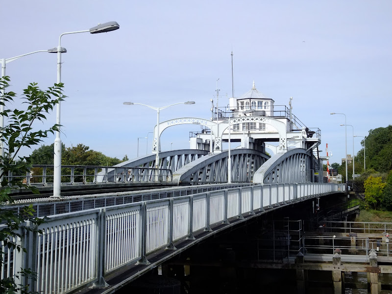
This walk was undertaken on a Sunday with blue skies, warmth in the air and a last bit of summer before Autumn truly ushered in. The first section of the walk leaves Sutton Bridge by walking over the impressive iron swing bridge that the town is named after. These days, its twin spans carry each carriageway of the main A17 highway but originally it carried the Midland and Great Northern Joint Railway on one span and the road on the other. This combination lasted until 1965 when the railway was closed and the road took precedence on both spans. There are still subtle indications of the railways existence from Beware of Trains
signs to the distinctive buildings that were associated with the old railway.
The coast path is found on the east side of the bridge with a clear tall finger post that directs the visitor to The Lighthouse, The Peter Scott Walk, a Picnic Site and a Cheese Farm. This points one down a long straight tarmacked lane that follows the course of the river. Cows graze nonchalantly on the grass banks of the river as well as standing in the road, begrudgingly moving when ever a car or bicycle parade down the lane. A lonesome apple tree stands on the bank and provides an opportunity to add to rations for later in the walk. A grand House sits aside the lane. Nene Lodge Farm. Could this be the infamous cheese farm? There are no other clues as to its whereabouts and no sign of cheeses. No country Stilton lazily grazing in the meadows. No curd idly fermenting under the warm sunshine. No visiting Camembert offering a continental flavour. Nothing. Not even a lost slice of cheddar let alone a rare sighting of a Venezuelan Beaver Cheese. How disappointing.
This lane was certainly popular on this particular Sunday with numerous folk heading seawards along its route. Cars with couples, families on bicycles, kids racing each other into the distance. This would appear at first sight to be a very popular walk. A car park by the Peter Scott lighthouse appears to be the destination for these folk, from where they embark out onto the footpath leading along the defence bank that borders the marshes beyond the lighthouse. However these folk do not venture further than the first turn, the point where they all return to the safety of civilisation. The rest of the walk was done without meeting another soul until West Lynn came into sight.
What is probably most surprising to any new visitor to this area are the islands that are in the Wash. One doesn't expect to set ones eyes on islands out here in this flat landscape. The Wash islands certainly are not a feature of any geographic syllabus that I know of and their recognition is certainly one of obscurity, so much so that I have never heard a single question about these landmarks appear on the numerous TV quiz programmes or even in pub quiz nights. The first island sits qa mile or so off the coast, beyond the outlet of the river Nene. The second is encountered further along the footpath and is connected by the marsh at low tide. Both have a symmetrical nature and look too uniform to be considered natural. This is probably because they are not natural, and as such offers a clue as to their lack of status in the world of islands for they are the white elephants of islands.
Back in the 1970s some bright spark had the great idea of creating a freshwater reservoir in the wash and set about bringing such wild dreams into reality. The large outer island, known as the Outer Trial Bank is actually hollowed out like a doughnut. The second island is just a mound and known as the Inner Trial Bank. After spending £3 million constructing these features it was determined that the idea was not feasible and they were abandoned to the wildlife. And there they rest. Looking anomalous and out of place and unknown to everyone apart from the locals and walkers who venture out to these parts.
One has to say that the final section of the walk into West Lynn was a little disappointing. The route follows the river but a large hedge masks all views and the long featureless fields the path runs through make the walking somewhat monotonous and tiresome. This may make walking the opposite direction more favourable, when fresh legs can cantor through this boring section with the enticement of the wide open areas of the Wash pulling one forward. The end of the walk would then be the lighthouses and the picturesque wander alongside the Nene to the bridge.
Once at West Lynn one can take the ferry across to Kings Lynn, or return to the start using the 505 bus service. In this instance, camping at Fleet Hargate, the 505 service made a useful connection to both ends. Unfortunately no pub could be found in West Lynn. The Bentnick Arms, the Estuary Tavern, the White Swan, the Cherry Tree, the Ferry Boat, Peto's Tavern and the Yacht Tavern, are names of old Inns that have now all long gone, such is the dying trade of the public hostelry. The weary traveller has to suffice with whatever they can find at the local general store or continue on to Kings Lynn. In this instance, the journey across the river is treated as a separate walk that also included a meander of the town trail which can also be found on this site.

Directions
Flood defence banks lead the entire distance from Sutton Bridge to West Lynn
The Peter Scott Walk is well signed on the eastern side of the bridge at Sutton Bridge. This leads down a tarmacked track to the lighthouse. Take the path around the river side of the lighthouse which leads on to the defence banks. Keep to the outer defence banks through to the River Ouse. The final section leads through a series of long thin field strips alongside the River Ouse with high hedges on either side. Follow these through to the village of West Lynn. Not all buses pass through the village, a bus stop for those that do not is on the Clenchwarton Road, a few hundred yards west of the junction with the road into the village.
Features
Ongar HillView in OS Map | View in Google Map
Walking eastward along the coast path, at the point where the path turns towards the River Ouse, one can catch site of a brick tower standing proud in front of a small piece of woodland. One can actually get to this feature via the former defence bank, as marked on the OS map, which branches close to Admiralty Point, rejoining the outer bank as it meets the river. The structure would offer questions to any curious wanderer as to the function it once served. Lurking in the distance, with small windows and a blank dark opening for a door and what looks like a full opening on the top storey, its appearance is one of sad decay, forlorn and untended for in years.
This intriguing landmark is in fact the former observation post for the WWII defence installation known as Ongar Hill Battery. The name may be deceiving for the is no obvious sign of a hill, but then any gradient in these parts is referenced as a hill. Locals would testify to this fact with the proof being that a storm surge in the 1960s came up to this bank by the hill, an assertion that this was higher ground.
The tower is just a small part of the battery complex which also includes a magazine, two gun houses and a close defence blockhouse, more colloquially known as a pillbox. It is thought that the soldiers who manned this complex may have been barracked at Greenland Farm.
The observation tower, a tall three-story tower of brick, is thought to be a unique example in Norfolk. The site, which was also referred to as King's Lynn battery, was in action between 1940 and 1943 and housed two 6 inch guns which were mounted on the roof. However, the shallow waters and extensive marsh meant that any invasion by ship would be too distant for the guns to be effective and in 1942 the guns were moved to Northumberland and the site abandoned.
The tower is currently in a ruinous state with all the floors collapsed although the gunhouses and magazine are still in relative good condition.
References
- Eastern Daily Press Feature - Walk around Ongar Hill
- Norfolk Heritage Explorer website - Record details for Kings Lynn coastal defence battery
- Derelict Places forum page with numerous photos of the Ongar Hill Defence battery
- 28 Days Later - Urban Explorer website - Report: Ongar Hill Coastal Defence Battery, Norfolk (12/10/2008)

Gallery
Below are a selection of images taken from from the photo album for this walk. Feel free to browse through these or click on an image to view a larger version in the Gallery.


Summary of Document Changes
Last Updated: 2021-12-07
Coast Walk, Distance:Hike, Features:Local History, full-detail, Lincolnshire, Norfolk, OSmap:249, The Wash Coast Path


0 comments:
Post a Comment