Talybont Reservoir Circular Walk
|
Wednesday 5 December 2018
|
No comments |
![]()

An easy walk to Talybont Reservoir in the Brecon Beacons along the old tramway
This route details a circular walk from the village of Talybont-on-Usk to Talybont Reservoir. The route follows the trackbed of the former 19th century tramway that once provided the means to transport the output from the collieries and quarries down to the canal. As with anywhere in the Brecon Beacons, the views are awesome, the landscape magnificent and this is such a simple walk that anyone with an average level of fitness and ability can undertake.
Talybont Reservoir Walk - Essential Information
Walk Statistics:
- Start location: Talybont-on-Usk
- Distance: miles ( km)
- Total Gain: ft ( metre)
- Total Descent: ft ( metre)
- Min Height: ft ( metre)
- Max Height: ft ( metre)
- Walk Time:
- Walk type: Circular
- Walk Grade: easy
- Terrain: Former trackbeds and country lanes
Maps:
The following maps and services can assist in navigating this route. There are links to printed maps and links to downloadable GPX route data for importing into navigational software and apps.
- Ordnance Survey Explorer Map
- OS Explorer OL12 - Brecon Beacons National Park
- GPX Route File
Route Verification Details
- Date of Walk: 2017-11-01
- Walk Time: 10:30 to 12:00
- Walkers: Griffmonster, Kat, Jason, DaisyMay, Dan, Anita
- Weather Conditions: Bright sunny warm day
Walk Notes
This walk was another of those whirlwind visits to an area where no prior plans had been firmly established. It all happened spontaneously on a day trip to the Brecon Beacons to view the mountains and landscapes. Heading up the A40 from Abergavenny towards Brecon, with the hope of finding somewhere to drop the car and have a walk, an on the spur of the moment decision was made to turn off down to the village Llangynidr in the Usk valley and what a result this led to. This was picture postcard stuff in all its glory. All of a sudden from a major route between key places on the edges of the Brecon Beacons we were whisked into a different world of mountains and villages and everything that one associates with this area of the country.
Practically all of the walks on this site start off with an undocumented ramble of discovery. Very rarely are they researched prior to the actual walk. It is much more interesting to let the features, sights and encounters spark the intrigue to investigate further once the walk is complete. Usually the route is pre planned but in this instance it was to be a case of setting down the motor and then looking for a path or track and making up a route on the hoof. The car was parked along the road in the peaceful village of Talybont-on-Usk after seeing a series of waymarkers. And so a voyage of discovery and adventure began.
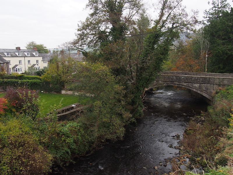
Talybont nestles in the valley where the Monmouthshire and Brecon Canal weaves its way through the hills down towards Newport. The route of the canal is displayed on a bench alongside the canal tow path, the backrest and seat baldly inscribed with a map of its journey. There is also an aqueduct at this point allowing one to proudly traverse this structure in the firm knowledge that aqueduct traversal is not an everyday pleasure and something to be savoured. Of course, in such situations, the rambling thought does pop into ones head that the aqueduct was one of the many things given to us by the Romans, or more specifically popularized by Monty Pythons What did the Romans ever do for us
sketch. This example is certainly not Roman as it was built, along with the canal, in the very late 18th century to provide a waterway connection from the upper Usk valley to transport the goods from the area to the cargo ships that docked at Newport.
It was at this point a decision had to be made. Whether to continue along the canal path or follow markers that heralded the Taff Trail
. Bearing in mind the canal path was probably going to be a linear walk with return along the same route, the Taff Trail seemed to be the better option. This led over a bridge and up the hillside. On the map it depicted the route up to the Talybont Reservoir from where a country lane back to Talybont could be used to make a circular route. A walk had been established.
It would appear that the Taff Trail is a 55 mile route that links Cardiff Bay and Brecon and is accessible both as a cycle route and long distance footpath. A leaflet for the trail can be downloaded from the Sustrans Website.
Just beyond the bridge there were information boards to inform the humble walker that this part of the Taff Trail followed the former Brinore Tramway, a horse-drawn narrow-gauge railway built in 1814 to transport the output from the collieries and quarries to the barges on the canal. The introduction of steam locomotion spelt the end of the tramway when a new line was established by the Brecon and Methyr Railway company. The steam engines were too heavy to work the steep inclines of the tramway and trade soon swapped for this option which used a lesser gradient around the mountains. The railway ceased operating in 1962 but the bridge across the canal still exists albeit in partially dismantled state.
The trail follows the tramway up the hillside of the Caerfanell valley with views across to hills and mountains with unfamiliar names such as Alt Ddu and Bryn and Twyn-du. In the distance, up the valley, is the Reservoir with its dam holding back the shimmering mass of water that reflects the hills, the sky and everything else in the known universe. A path drops down to the former railway trackbed just short of the Reservoir dam and at this point there is a brick structure cut into the hillside that does look as if it was a link between the tramway and railway. It was far too steep for steam engines and very dubious for even horses with a truck load to negotiate. I can find nothing to establish exactly what this was so it will have to remain a curiosity for the time being.
The track emerges onto the roadway across the dam and one can stand and stare at the waters. The reflections are awesome and instantly photographic from all angles, exposures and angles. Below is a pumping station and overflow channel that feeds back onto the original Caerfanell River. There was once a corn mill here but that is long gone, probably removed for the construction of the pumping station which was constructed in the early 1930s.
Reservoirs always provide the intrigue as to what may lie beneath them. What lost villages, or ancient churches lie beneath these depths. Such thoughts retrieved memorable accounts of Lake Guerlédan in Brittany, France which was recently drained to display a long lost treasure of a past world full of all manner of curiosities. What lost tales are hidden below the depths of Talybont Reservoir which has flooded the valley for the past near century. Perhaps very little. There are online OS maps from the early 20th century and these certainly depict a somewhat uninhabited valley.
The return route is so simple, down the lane back to Talybont passing through the hamlet of Aber where the Clydach stream thrashes its waters under the road bridge. Talybont also offers the unique views of a tin tabernacle and a drawbridge across the canal. The drawbridge is a most intriguing structure that has to be lifted for even the lowest of canal craft, even a canoe would struggle to get under its lowered position. Although, no doubt, there are a few canoeists out there who would attest they have achieved such a feat.
Directions
A circular route from Talybont-on-Usk to the Talybont Reservoir
Make one way up to the Canal at Talybont-on-Usk using the road that is signposted to the Talybont Reservoir. Turn left onto the canal tow path by the drawbridge and continue along this path until it meets the two bridges over the canal, the first is a road bridge and the second the former railway bridge. Take the path that leads up and over the first bridge. Follow the trackmarked with the Taff Trail markers.
Keep to this until a path diverges on the right which is marked as the Taff Trail. This slowly descends to join the former railway trackbed up to the start of the reservoir. Turn right at the reservoir and follow the road across the dam.
At the far end of the dam turn right and follow the lane. Continue along this until there is a junction off to the right signposted for Talybont-on-Usk. Take this to return to the starting point.

Features
Talybont Railway CrashesView in OS Map | View in Google Map
The Brecon and Merthyr Railway was established in the 1860s with the first section of the single track line between Brecon and Pant opening on 1 May 1863. This section included stations at Brecon, Talyllyn, Talybont, Dolygaer, and Pant. Subsequently the railway continued across the challenging landscape of the Brecons which required some extreme gradients to be implemented. This included a notorious gradient named as the seven mile bank that rose out of Talybont on a 1:38 (2.6%) incline alongside Glyn Collwyn to the Torpantau tunnel, which at 1,313 feet, was the highest railway tunnel above sea level.
With such an inclines it is no surprise that a number of accidents resulted from runaway trains which failed to negotiate the gradient in a safe manner. There are two notable accounts from the late 19th centuries.
One accident occurred on 8th June 1868 when a freight train with engines both front and rear was descending down seven mile bank. The front engine had not shut off the steam early enough and had reached 15mph at the top of the gradient which was far too much speed. Despite braking being applied the trains speed increased to an estimated 30 to 40 mph. At Talybont the signal was at danger but neither driver attempted to reverse their engine and it was too late to stop them colliding with the obstructing line of trucks ahead. At the foot of the bank, where the line curves round towards Talybont station, the leading engine came off the track and the whole lot piled up on the roadway below the bridge.
Another incident took place on 2 December 1878 when a freight train being hauled by three 0-6-0 saddle tanks was descending the seven mile bank. Inadequate braking applied to the 36 wagons resulted in the train running down the gradient out of control. It derailed close to Talybont, throwing its load down the embankment and killing two drivers and two firemen.
It is thought that the second incident took place somewhere close to Talybont station and it interesting to note a little spooky story that may be related to this fatal accident. The account of the ghostly tale is highlighted by the Strange Days website which has the splash-line of Paranormal stories from the UK and beyond.
Unfortunately this references pages from the BBC website which are no longer available either from the actual BBC site nor have been archived on archive.org. However a documented link to the original account has been found on archive.org where the respondent states If you follow this link www.bbc.co.uk/wales/mid/sites/weird/pages/hannah.shtml, you will find some scary stories about the old railway station in Talybont which is now an outdoor education centre.
Therefore, it is worth repeating this article extract such that it will not get forgotten in the annuls of time.
The story is related by a person named Hannah who states that she was staying at the Talybont Outdoor Education Centre as part of a school trip. This centre is part of the Gwent Outdoor Centres and has converted the former Talybont Station buildings into an educational centre for youth groups and schools where they can get involved in environmental and adventure activities in the mountains. Hannah wrote into the BBC which was published on the Talybont-on-Usk web page, stating It was a cold winter night and we were on a school trip to Talybont for the weekend. We were sleeping in dorm 4 - no-one was sleeping in dorm 5. Me and my friend Lucy went into dorm 5 and we were sure we heard train noises and screaming, but no one else heard it. We asked the teacher what had been there before it became what it is now, and he said it had been a train station, which we thought was weird.
This does make one wonder if there is any significanc between this and the fatal 1878 accident.
References

Gallery
Below are a selection of images taken from from the photo album for this walk. Feel free to browse through these or click on an image to view a larger version in the Gallery.


Summary of Document Changes
Last Updated: 2021-12-07


0 comments:
Post a Comment