A Walk to Baconsthorpe Castle Walk Summary
|
Tuesday 31 July 2018
|
No comments |
![]()
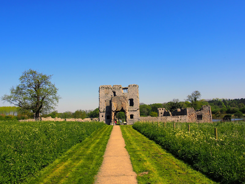
An easy walk to view the ruins of Baconsthorpe Castle with return route to Sheringham
The remarkable ruins of the moated and fortified 15th century manor house known as Baconsthorpe Castle lie to the south of the village of Bodham on the main A148 road close to Holt. Footpaths and lanes provide access through to this isolated wonder that lie hidden in the Norfolk landscape. The Castle is currently under the tenure of English Heritage and entry is totally free. The landscaped area is surrounded by a picturesque moat and information boards document the history of the ruin. This really is something worth visiting so allow at least an hour to peruse this piece of Norfolk history.
In order to get to the start of the walk, there is a frequent seven day a week bus service linking Sheringham and Bodham. After navigation to the ruins, the return is via the village of West Beckham where there is the Wheatsheaf pub for lunches and refreshment. A footpath leads down to the main road from where permissive paths through Sheringham Park provide an interesting and pleasant route through to Upper Sheringham. This route follows the parks Temple Walk and then continues onto Park Road to emerge back on the road at Upper Sheringham. The park is open from dawn to dusk and outside of these hours one is required to walk down the B1157 which has no pavement making a hazardous route, particularly during holiday periods.
There are pavements between Upper Sheringham and the main town and the walk ends at the bus stop adjacent to the North Norfolk Railway station.
A Walk to Baconsthorpe Castle - Essential Information
Walk Statistics:
- Start location: Bodham
- End location: Sheringham
- Distance: miles ( km)
- Total Gain: ft ( metre)
- Total Descent: ft ( metre)
- Min Height: ft ( metre)
- Max Height: ft ( metre)
- Walk Time:
- Walk type: Linear
- Walk Grade: easy
- Terrain: Footpaths and tracks with some country lanes predominate this walk. The route through Sheringham path uses permissive paths which are signposted as the Temple Walk
Maps:
The following maps and services can assist in navigating this route. There are links to printed maps and links to downloadable GPX route data for importing into navigational software and apps.
- Ordnance Survey Explorer Map
- OS Explorer 252 - Norfolk Coast East
- GPX Route File
Accommodation:
Woodhill Park CampsiteView in OS Map | View in Google Map
- Website
- https://www.woodhill-park.com/
- Description
- Located on the clifftops at East Runton, half way between Sheringham and Cromer, this highly recommended touring site is ideal for exploring North Norfolk with public transport available to many destinations from the entrance to the site.
Route Verification Details
- Date of Walk: 2018-05-06
- Walk Time: 10:00 to 14:30
- Walkers: Griffmonster, Kat
- Weather Conditions: Sunny day
Directions
Summary of Document Changes
Last Updated: 2021-12-07


0 comments:
Post a Comment