Bittern Line Walk - Cromer to North Walsham
|
Thursday 21 March 2019
|
No comments |
![]()
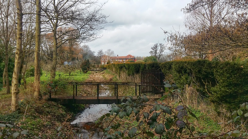
A 11.5 mile walk following the Bittern Line between Cromer and North Walsham
The Bittern Line provides the rail gateway to North East Norfolk from Norwich. Although there are no officially documented walks that link its stations, this walk seeks to rectify this and links Cromer and North Walsham using country lanes, footpaths and tracks. Stunning countryside, typical Norfolk villages and always something new to discover.
Bittern Line Walk - Cromer toNorth Walsham - Essential Information
Walk Statistics:
- Start location: Cromer
- End location: North Walsham
- Distance: miles ( km)
- Total Gain: ft ( metre)
- Total Descent: ft ( metre)
- Min Height: ft ( metre)
- Max Height: ft ( metre)
- Walk Time:
- Walk type: Linear
- Walk Grade: hard
- Terrain: Footpaths, country lanes
Maps:
The following maps and services can assist in navigating this route. There are links to printed maps and links to downloadable GPX route data for importing into navigational software and apps.
- Ordnance Survey Explorer Map
- OS Explorer 252 - Norfolk Coast East
- Ordnance Survey Explorer Map
- OS Explorer OL40 - The Broads
- ViewRanger App Route
- ViewRanger Route
- GPX File
- Downloadable GPX File
Accommodation:
Cromer House Bed and Breakfast View in OS Map | View in Google Map
- Website
- http://www.cromerhouse.co.uk/
- Description
- Just 50m from the sea front with its lovely sandy beach, we are an easy stroll away from the Pier and Town Centre with its many bars, restaurants, shops and other amenities. The comfortable rooms, Good Food Welcoming atmosphere This all adds up to a relaxing stay at Cromer House
Transport:
Details of public transport that is required for the walk
Greater Anglia - Train Service
- Service Details
- Bittern Line - Bittern Line linking Norwich with Cromer and Sheringham
- Timetable
- Bittern Line
Route Verification Details
- Date of Walk: 2019-03-08
- Walk Time: 09:00 to 13:00
- Walkers: Griffmonster, Kat
- Weather Conditions: Bright sunny spring day with a brisk north easterly wind
Walk Notes
The is no definitive direct footpath link between the towns of Cromer and North Walsham. The Paston Way does offer a route via Mundesley and the coast which is a lengthy 30 miles in total. This is a worthy challenge for a summers day where time is no issue and one can take in the numerous historic churches along the route. A shorter route along this trail can cut the distance down to 22 miles and following the original route can reduce this to 20 miles. Even so, this is not something one can undertake in a morning or afternoon and this is where this walk comes into play.
This route roughly follows the railway line between Cromer and North Walsham passing close to the stations of Roughton Road and Gunton for those who prefer a shorter wander. This fairly direct route uses footpaths and country lanes and at only 11.5 miles can be undertaken by anyone of average fitness. The two ends of the route are connected by the Bittern Line railway where a regular service is offered seven days a week. The line is seen, passed over, passed under and generally close by throughout the entirety of this walk.
Starting at Cromer Station we navigate along the eastern edge of the town following the perimeter of East Wood up to Roughton Road. New housing estates are springing up along this road, taking up the space between the woodland of Burnt Hills and Brown Hill. One can see the railway bridge crossing the road just beyond the woodland and this is the location of Roughton Road station. Before the woods, we take the road into the housing estate and although there is no thoroughfare that links across to the main Norwich road, there is nonetheless a cut-through walkway alongside East Woods to that leads onto Hillside and emerges on the main road opposite the site of the former Cromer High Station. This was the towns original railway station and was built in 1877. However by 1906 the Beach station had opened which provided a much more convenient setdown for visitors to the town and passenger numbers at the High station substantially dropped. Despite this, the station remained open until 1954.
There is a short distance of pavement walking alongside the main road which passes over a railway bridge under which the former Mundesley branch line passed. The track is now long gone but peering over the parapet one is greeted with the sight of the entrance to Norfolk's only railway tunnel. The entrance is still accessible although the cutting is overgrown and modern builds around the area prevent any easy access down to it.
We continue onwards, taking The Avenue off to the left. This leads back over the railway cutting the other side of the tunnel then turns a sharp right to present a long straight country lane that leads directly to Northrepps Hall. Although this is predominantly a converted 19th century farmhouse, some resources appear to indicate that it dates from the 17th century.
Turning right at the junction with the Hall entrance we take a slowly twisting lane back under the railway and in to the hamlet of Crossdale Street. Tracks then cut across the country side, back over the railway and onto the village of Northrepps continuing on to Southrepps which is dominated by its church of St James which has one of the tallest towers in the whole of Norfolk. There is the chance of refreshment here with the Vernon Arms pub located on the corner of the High Street and Church Street.
The route now follows the Paston Way down to Lower Street where there is a pleasant ramble through the wooded heathland. For those wishing to curtail the route at this point one can take the road down the side of the woodland and then turn right at the junction which brings one to Gunton Station.
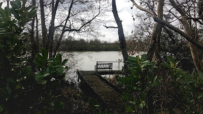
A footpath can be found on the right of Bradfield road some 400 yards beyond the crossroads. This is a former route of the Paston Way and leads through to Antingham. On OS maps the footpath turns right at Goldens Farm and leads down to the road. Ignore this and follow the track straight ahead. There is no indication that this is private and the track merely leads past the entrance to a farm house proudly flying a Norfolk flag atop a tall flagpole. It then continues out to the junction with Pond Road, a narrow country lane that leads past the Antingham Ponds, and area of woodland and lakes. Although there are boadwalks through the woods all of this inviting area is private ground and there is no public access. One can catch glimpses of the benches looking across the lakes. Lakes! yes they look like lakes. Large bodies of water that appear to go beyond the definition of a pond although there appears to be no distinct difference between what makes a body of water a pond and what makes it a lake. In this case, this specific body of water served a mill and was therefore the millpond. Millpond! I guess that makes it a pond as the term Millpond is much preferred to that of mill-lake.
The mill at the head of this water is the Antingham lower Bone Mill employed to crush animal bones for use as fertilizer which was shipped out along the Dilham Canal which started just below the mill, following the course of the River Ant dopwn to Dilham where the river was navigable to the Wherries, the name given to the local river sailing craft that once plied these waters. The canal opened in 1826 and allowed the Wherries to navigate through to North Walsham and Antingham.
The walk continues along the country lanes along Lyngate Road taking a footpath across the fields as the road turns a sharp left. There is a short distance up Bradfield road where two cottages stand by the roadside, one with a rusting remnants of an old traction engine in its grounds and the other having the box wagon to an old 1970s Betabake bread delivery lorry. It is amazing what one sees in the country side.
Another footpath along the field boundary leads into Lyngate Industrial Estate on the edge of North Walsham. The main road that runs alongside this area and under which this walk navigates via a old brick bridge was the route of the old Mundesley branch line, the same line that passed through the tunnel back in Cromer. Back in the day North Walsham was an important railway junction and had two stations that sat adjacent to each other, the Town Station, which is now long gone, replaced by the A149 trunk road through the town which follows the old route of the railway. The station sat just south of the traffic lights at the large junction with the Norwich road. The Main Station still exists and is now part of the Bittern Line and the place to catch the train back to Cromer.
However before walking out to the station one needs to call into the Hop Inn, a former small house on Market Street that serves a variety of ale and ciders straight from the cask. The only entertainment is conversation, which there is never a shortage of, and comestibles are local pork scratchings served by the half pint. This really is well worth visiting and a fitting end to a great walk.
Directions
Summary of Document Changes
Last Updated: 2021-10-20


0 comments:
Post a Comment