East Northants Greenway - Rushden to Irthlingborough
|
Sunday 3 March 2019
|
No comments |
![]()
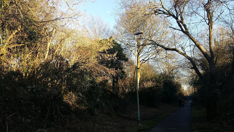
Easy walk that navigates through Rushden and Higham Ferrers, ending up at Irthlingborough
A trail that uses the former trackbed for the Rushden and Higham branch railway, together with the old trail across the Nene Valley to Irthlingborough
Rushden Lakes to Higham Circular Walk - Essential Information
Walk Statistics:
- Start location: Rushden Lakes
- End location: Irthlingborough
- Distance: miles ( km)
- Total Gain: ft ( metre)
- Total Descent: ft ( metre)
- Min Height: ft ( metre)
- Max Height: ft ( metre)
- Walk Time:
- Walk type: Linear
- Walk Grade: easy
- Terrain: Well maintained track
Maps:
The following maps and services can assist in navigating this route. There are links to printed maps and links to downloadable GPX route data for importing into navigational software and apps.
- Ordnance Survey Explorer Map
- OS Explorer 224 - Corby, Kettering & Wellingborough
- GPX Route File
Accommodation:
Rushden (Wellingborough) TravelodgeRoomView in OS Map | View in Google Map
- Website
- https://www.travelodge.co.uk/hotels/190/Wellingborough-Rushden-hotel
- Description
- Basic but comfortable rooms. Adjacent to Rushden Lakes.
Route Verification Details
- Date of Walk: 2019-02-17
- Walk Time: 10:30 to 12:30
- Walkers: Griffmonster, Kat
- Weather Conditions: Clear blue skies
Walk Notes
The East Northamptonshire Greenway is a proposed cycle and footpath that, once completed, will connect Wellingborough Railway Station to Peterborough Railway Station. The section that connects the Rushden Lakes area with Higham and Irthlingborough was constructed between 2011 and 2013 making use of the former trackbed of the Rushden and Higham Branch line and existing footpaths across the Nene Valley. This is a hard surfaced path accessible to all whether on foot or in saddle.
The start of this section is accessed from Crown Way on the Crown Industrial Estate opposite Rushden Lakes. The path starts just past Freemans Transport on the right where signs direct the walker through to the Greenway on the former railway route providing a direct traffic free route into the town centre.
The Rushden and Higham Branch line was constructed in the late 19th century and provided a transport link to the mainline at Wellingborough until 1969 when the last freight train used the rails. Dr Beeching's cuts of the rail network in the early 1960s saw the end of passengers workings on the line although on a damp Sunday in 1968 a branch line special pulled into both Rushden and Higham stations for one final visit by a passenger service. Such an occasions warranted attendance by the whole family and I certainly have distinct memories of standing on the footbridge as the smoky old DMU pulled out of the station on that day. A few family photos of this event were taken on the day but unfortunately after lending these for inclusion in local history publication they were lost and now only memories exist if this event. I would guess somewhere in peoples archives, or gathering dust on some bookshelf are copies of that old book with the faithfully reproduced images.
The trail soon reaches the Washbrook road bridge and continues down the back of Midland Road, named after the former railway company. This is where as youngsters my brother and myself would stand and watch the class 26 Birmingham RC&W locos that would haul coal wagons to the local gas works. On the opposite side of the line was a cut through to Fletcher Road where us kids would steal across the railway in order to get access to Spencer Park. Although not marked on any maps as a footpath, more recent research has found that there was indeed a right of way down here.
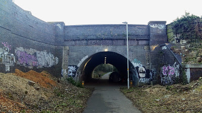
The path then tapers down to the High Street junction with Station Approach. This is where an iconic iron bridge straddled the road. The bridge was demolished in 1973 and it was sometime around this period that my collar was firmly felt by a member of the local constabulary after climbing the embankment to get a view of the bridge. The policeman forced me back down the embankment,losing is helmet in the process which toppled down to the street. There was then a cautious reprimand dished out to us mischievous kids which included a heedful word in the ear with the threat of informing parents. Back in those days it was enough to deter us from attempting the feat again.
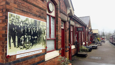
There is a short walk up to the former station buildings, now the home to the Rushden Historical Transport Society. A line has been reinstated here and a menagerie of old vehicles and rolling stock that is assembled along the line in front of the station and across the road at the former goods shed. It is well worth taking time out to visit the station where one of the former waiting rooms has become the societies museum and the old ticket office has been converted into an award wining bar complete with Victorian gas lighting.
The society was formed in 1976. The Rushden Heritage website states that the inaugural meeting was held at the Rose and Crown pub, a fact that I would contest. At the time my brother, a couple of friends and myself, all being staunch railway enthusiasts, attended that first meeting. Being under age we managed to get pints of beer served to us and then paraded up the stairs to the meeting that was conducted in an upper room at the Waggon and Horses pub in High Street South. This was a very busy affair and the website stating there was 80 people in attendance probably was not too far wrong. This was my first ever visit to this particular drinking establishment and therefore set in my memory.
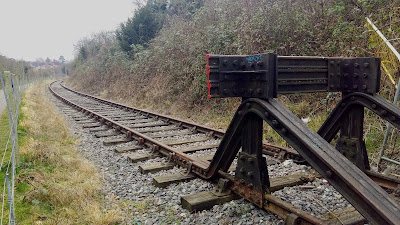
The path continues further up the road, leading back onto the old railway route where a section of line continues as the route bends around and heads towards Higham. Beyond this, the path continues, noticeably providing enough space for a further line extension through to Higham.
At Higham the route departs from the former trackbed and navigates through a housing estate to pick up the former track through to Irthlingboorugh. This has been improved in recent years and now presents a hard surfaced path down to the river and across the Nene Valley. As on this occasion a circular walk can be created by taking the track along the former Northampton and Peterborough trackbed back to the Rushden lakes area.
Directions
Simple walk around the Skew Bridge Ski Lake
The walk starts and ends at the decking by the Wildlife Trust Visitor Centre that looks out from the shopping complex across the lake. The walk is waymarked and is a simple circular route following the edge of the lake. One cannot get lost.
Summary of Document Changes
Last Updated: 2021-12-07


0 comments:
Post a Comment