Rendlesham Forest and Butley Walk Summary
Thursday, 16 August 2018
|
No comments
|
![]()
A woodland walk, a UFO encounter, quiet country lanes and a good old country pub
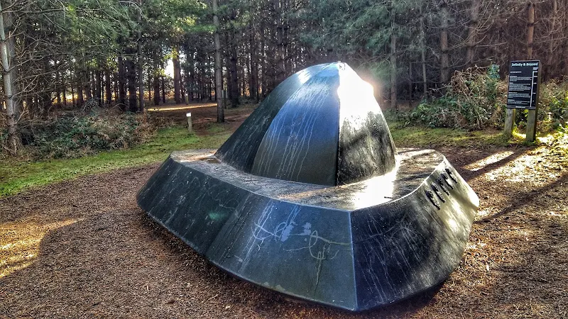
This is a great way to spend a day exploring. Rendlesham forest has many trails created by the Forestry Commission in order to discover this working forest. However this trail goes off piste to discover a little more. The first notable thing of the walk is the runway close to the car park. Although now redundant, this was a RAF air base that was taken over by the USAF and was a key hub during the Cold War. The forest surrounding the base is renowned as the location of a UFO encounter by US military that occurred during December 1980 and the Forestry Commission have a trail dedicated to this. The first part of this route heads out along this trail to view the UFO sculpture that depicts the craft encountered at one of the alleged landing sites. Some claim that the forest is still subject to strange unearthly occurrences so tread carefully!
The route heads out to view the curious sculpture which substitutes as the village sign for the village of Capel St Andrew. This iron man was commissioned at the millennium and created by local sculptor Paul Richardson. It is said to represent St Andrew as a fisherman, with his left hand clutching an eel whilst his right holds a fish. He is surrounded by oak trees that once covered this landscape and at his feet is a chapel from which the word capel is derived.
The walk also pays a visit to the ruins of Butley Abbey which dates from the 12th century. All that is left is a tall arch from the original church building which is now hidden away within a group of farm buildings. Further north is the impressive building of Butley Priory which was originally a 14th century gatehouse to the abbey. These days it is renovated and used as a wedding venue.
More information on the UFO encounter can be found at An Extended Walk around the Rendlesham UFO Trail.

Walk Statistics
- Start location: Rendlesham Forest
- Distance: miles ( km)
- Total Gain: ft ( metre)
- Total Descent: ft ( metre)
- Min Height: ft ( metre)
- Max Height: ft ( metre)
- Est. Walk Time:
- Walk type: Circular
- Walk Grade: easy
- Terrain: Woodland trails, country lanes and footpaths.
- Obstacles: The tracks through Rendlesham Forest is on well marked tracks. To follow this specific route it is advised to use a GPX navigation app, otherwise use the UFO Trail to navigate to the UFO sculpture then head around the eastern side of the forest and exit via the motorcross track. Note that the forest is a working woodland and as such logging operations do occur when sections of the forest become out of bounds

Maps
The following maps and services can assist in navigating this route. There are links to printed maps and links to downloadable GPX route data for importing into navigational software and apps.
- Ordnance Survey Explorer Map
- OS Explorer 212 - Woodbridge & Saxmundham
- GPX Route File
Route Validation Cards
Validation Date - 2018-02-17
- Time of Walk: 11:00 to 14:30
- Validators: Griffmonster, Kat
- Weather Conditions: Bright sunny day
- Notes: Initial route undertaken
Summary of Document Changes
Last Updated: 2026-01-12
- 2021-03-17 : Update website improvements and removal of ViewRanger reliance
- 2021-12-01 : Removal of ViewRanger links due to its imminent demise


0 comments:
Post a Comment