Route details, maps, pubs, features, local history and folklore for a wide variety of walks focusing primarily on Norfolk and Suffolk

Walks
Showing posts sorted by date for query Burgh Castle. Sort by relevance Show all posts

Wednesday, 18 December 2019

Bure River Walk from Coltishall to Brampton

Buxton Mill

An easy and captivating walk along Norfolks River Bure

Not only does this walk provide some classic Norfolk scenery and historic features but it also traces the route said to be taken by the phantom carriage of Sir Thomas Boleyn in his annual act of penance for betraying his daughter Anne when she was sentenced to be executed. The walk is then made into a circular route by returning via the Bure Valley Path alongside the narrow gauge Bure Valley railway.

Tuesday, 10 December 2019

Ouse Valley Way - Bedford to St Neots

River Ouse, Eaton Socon

A 17 mile riverside walk along the Ouse Valley Way between Bedford and St Neots

Despite the increasing urbanisation between Bedord and St Neots, the riverside sections of this walk provide some pleasant rambles. Particularly notable is the 15th century river bridge at Great Barford and the riverside parks at St Neots.

Exploring the Suffolk Coast and Heaths area of Oustanding Natural Beauty around Aldeburgh

Aldeburgh from the  River Alde estuary

A 12.5 mile walk between Aldringham and Aldeburgh through the Suffolk Coastal Area of Outstanding Natural Beauty

There is a variety of differing scenery along this route, gentle hills around Aldringham, boardwalks across the marshes at The Fens, a walk along the old Aldeburgh railway and an estuary walk along river defences of the Alde. With such treasures as the pretty little church at Aldringham, tucked away in the trees and away from civilisation and the magnificent church of St Peter and St Paul at Aldeburgh, there is plenty to see and explore.

Tuesday, 4 December 2018

A Walk to Languard Fort

A 10 mile walk from Trimley to Languard Fort via Felixstowe Ferry

This walk navigates from the village of Trimley down to Kings Fleet and along the banks of the River Deben to Felixstowe Ferry, the setting of an old Black Shuck tale from many years ago which is a feature to this walk. A coastal walk follows, along the seafront of Felixstowe through to the where the River Orwell meets the sea, a strategic point of defence against attacking enemies attempting to sail up the estuary. Key to that defence is Languard Fort which has stood here for many centuries and has played key parts in the world wars of the 20th centuries. A fascinating place to visit with a certain eeriness within its confines.

Saturday, 27 October 2018

Angles Way - Belton to Great Yarmouth
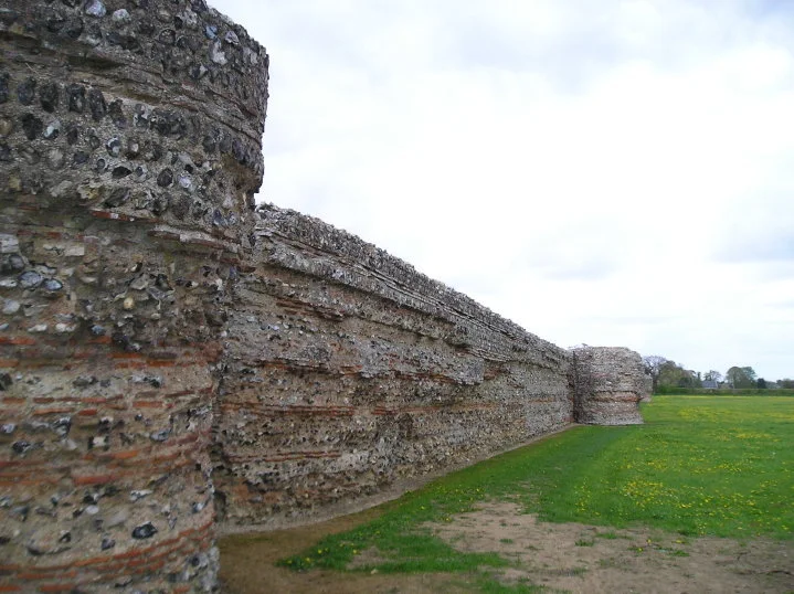
An 8 mile walk along the Angles Way from its start at Great Yarmouth to Belton

The Angles Ways journey begins with a walk along the banks of Breydon Water to Belton. Along this route can be seen the impressive remains of the Roman fort Gariannonum at Burgh Castle. This is a simple afternoons walk with a frequent bus service linking Great Yarmouth and Belton for the return journey. On this occasion we walked the path in reverse having set up camp at Belton.

Saturday, 16 June 2018

South West Coast Path - Westward Ho! to Barnstaple

Salt marsh

One of the few low level and flat walks on the SWCP, 12.5 miles between Westward Ho! to Barnstaple

A very easy walk that can be split into two if required. The first part navigates around Northam Burrows, the duned area that juts out into the Taw and Torridge estuary. A ferry at Appledore links across to Instow where the trail continues making use of the former Bideford and Barnstaple railway trackbed.

Walk Summaries

Latest walk summaries are basic information sheets for walks that have yet to be fully documented. These provide links to maps, public transport and walks stats, although detailed notes and features are not included.

Latest Walk Summaries

Featured Walk

In Search of Sizewell Chapel

A 10 mile walk following the southern side of the parish boundary of Leiston in Suffolk This walk follows the route of a 17th century peramb...

What is GPX

All you need to know about GPX, electronic mapping and how to use modern apps and mobile devices as navigation devices

Popular Walks

Maps