Walks
Showing posts sorted by relevance for query Westward Ho!. Sort by date Show all posts
Tuesday, 17 December 2019
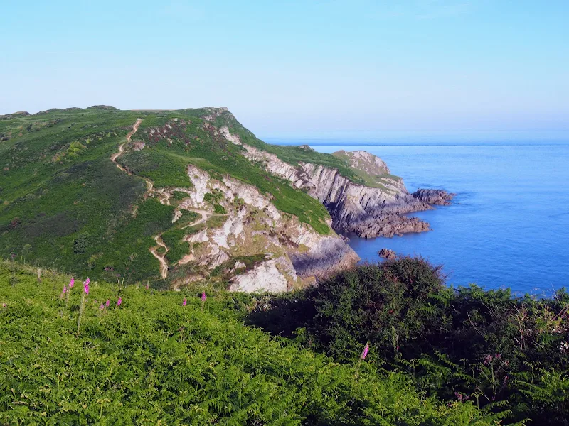
An 8 mile walk along the South West Coast Path between Bucks Cross to Westward Ho!A moderate walk along the cliffs to Westward Ho!, the town renowned for being the only place in Britain to have an exclamation mark in its name. This walk presents a good introduction to the South West Coast Path being...
Saturday, 16 June 2018
South West Coast Path - Westward Ho! to Barnstaple
Author: Griffmonster |
Saturday, 16 June 2018
|
No comments |
One of the few low level and flat walks on the SWCP, 12.5 miles between Westward Ho! to BarnstapleA very easy walk that can be split into two if required. The first part navigates around Northam Burrows, the duned area that juts out into the Taw and Torridge estuary. A ferry at Appledore links across...
Thursday, 5 July 2018
Hele Bay to Braunton Walk Summary
Author: Griffmonster |
Thursday, 5 July 2018
|
No comments |
Extensive Walk along the SWCP between Hele Bay near Ilfracombe and BrauntonThis route provides an alternative to the official SWCP whereby it short cuts the headland at Baggy Point and goes directly into Braunton omitting the section around Braunton Burrows. This achieves a sub 20 mile walk with bus...
Wednesday, 4 July 2018
Tuesday, 17 December 2019
South West Coast Path - Bucks Cross to Hartland
Author: Griffmonster |
Tuesday, 17 December 2019
|
No comments |
An 16 mile walk along the South West Coast Path between Bucks Cross and HartlandAn easy start to a walk through the tree covered cliff-tops makes a pleasant ramble through to Clovelly. There follows a couple of challenging valleys to cross and then broad open meadows for more easy walking through to...
Indexes and Info
Walk Summaries
Latest walk summaries are basic information sheets for walks that have yet to be fully documented. These provide links to maps, public transport and walks stats, although detailed notes and features are not included.
Featured Walk
In Search of Sizewell Chapel
A 10 mile walk following the southern side of the parish boundary of Leiston in Suffolk This walk follows the route of a 17th century peramb...

What is GPX
All you need to know about GPX, electronic mapping and how to use modern apps and mobile devices as navigation devices
Popular Walks
-
A 9 mile circular walk along the North Norfolk Coast between Holkham and Wells-next-the-sea An alternative to the North Norfolk Coast Path, ...
-
A simple 3.5 mile walk along side the North Yorkshire Moors Railway Amazing scenery with the sounds of steam engines chugging up the gradien...
-
A 9 mile walk following the Cleveland Way between Saltburn and Staithes This walk passes over the highest point on the east coast of England...
-
A 12 mile walk following the Cleveland Way between Staithes and Whitby A fabulous walk along the Yorkshire coast. Amazing views and not too ...
-
An 9 mile walk along the South West Coast Path between Port Isaac and Polzeath A stunning walk that is not too challenging. It starts at the...
-
An easy 8 mile Norfolk coastal walk along beach and clifftops between Sheringham and Cromer The Norfolk Coast Path was rerouted in 2014 as p...
-
Lowestoft to Southwold Beach Route An exhilarating 12 mile coastal walk along the Suffolk Coast. The Suffolk Coast Path runs between Lo...
-
A 10 mile walk along the South West Coast Path between Brixham and Kingswear. This section is one of the most strenuous walks along the Exmo...
-
A 15 mile circular walk along the Sandlings footpath between Dunwich and Southwold, with an option of returning either via the beach or the ...
-
A 6 mile walk along the original route of the Norfolk Coast Path between Cromer and Sheringham Up until December 2014 the official route of ...