Route details, maps, pubs, features, local history and folklore for a wide variety of walks focusing primarily on Norfolk and Suffolk

Features:Lighthouses Walks
Showing posts with label Features:Lighthouses. Show all posts

Thursday 24 February 2022

Norfolk Coast Path - Heacham to Brancaster

Heacham to Brancaster

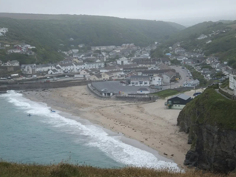
A walk of beach, prom, dunes and marsh. A thoroughly varied landscape all told

From the cliffs of Hunstanton to the marshes of Thornham, this walk gives a variety of scenery. The Norfolk Coast Path is an excellent way to explore this part of the British Coast and what better way to start than at the westerly end. Even though Hunstanton is the official start, there is a promenade from Heacham for those wanting to go that little bit farther. There's long sandy beaches, there's multi-coloured cliffs, there's dunes, marshes, nature reserves and creeks and even a Norfolk hill from where where you can view across The Wash to Skegness on a clear day. With excellent public transport links, plenty of watering holes and accommodation, this is indeed a most thoroughly recommended walk.

Wednesday 18 December 2019

South West Coast Path - Coverack to The Lizard

View to The Lizard

An 11 mile walk along the South West Coast Path between Coverack and The Lizard

A challenging but rewarding walk along the south West Coast path. There are spectacular views along the coastline with The Lizard being in view virtually the entire distance. The picture postcard village of Cadgwith is a worthy resting point before embarking on the final few miles that include the rock formation known as The Devil's Frying Pan.

Friday 11 January 2019

A visit to the rather curious Happisburgh

Happisburgh lighthouse

A simple 3 mile circular walk along the Norfolk Coast between Happisburgh and Eccles

Happisburgh is curious - it is slowly being taken by the sea, its houses slowly falling victim to the tides. The pub gardens boast a signal box to a railway line that never got built. A lighthouse stands guard to the south and its lifeboat is located at the next village of Eccles. In recent times the tide has uncovered prehistoric human footprints. And there is local folklore of ghostly smugglers and misdeeds. Very curious indeed.

Tuesday 8 January 2019

South West Coast Path - Lands End to Mousehole

Enys Dodnan

An arduous but rewarding 13 mile walk along the South West Coast Path between Lands End and Mousehole

This is an arduous section of the coast path but is nonetheless worthwhile for its spectacular scenery and rugged landscape. There is little in the way of civilisation throughout the entire route but the views and amazing with the natural wonders of the Longships rocks, Gwennap Head, Logans Rock and so much more.

Sunday 30 December 2018

Lancashire Coastal Way - Lytham St Annes to Fleetwood

Stormy scenes at Blackpool

A 15 mile way along the Lancashire Lancashire Coastal Way between Lytham St Annes and Fleetwood

The route goes through one of the principle holiday resort areas in England and the entire distance is walked along concrete promenades with access to the beach when the tide is out. There are numerous points of interest including the famous piers and tower at Blackpool and the constant trams that clank along the seafront.

Friday 28 December 2018

South West Coastpath - Par to Looe

Path to Polperro

A challenging 20 mile walk along the South West Coast Path between Par and Looe.

Some describe this as the most scenic of the south coast section of the Cornish South West Coast Path. There are the charming villages of Polkerris, Fowey, Polruan and Polprerro and the cliff-top path offers fantastic views along the Cornish coastline. Although the going is fairly strenuous around East Coombe, on the whole the path does not offer too much of a challenge other than in the sheer distance. Shorter walks can be planned using the bus services that connect Polruan and Polperro to Looe.

Sunday 23 December 2018

South West Coast Path - Portreath to Hayle

Portreath

A 12 mile walk along the North Cornish section of the South West Coast Path between Portreath to Hayle

Although there are a couple of climbs at the Portreath end of this walk, this is predominantly an easy clifftop path along with dune or beach walking across the sands between Godrevy Point and Hayle.

Friday 21 December 2018

South West Coast Path - Roseland Peninsular Circular Walk

Place ferry

A 9 mile circular walk around Cornwall's Roseland Peninsular taking in St Anthony's Head and Portscatho.

A simple and not too strenuous walk around the tip of the Roseland Peninsular. This encompasses the section of the South West Coast Path between Portscatho and the ferry point at Place that provides a service across to Falmouth. St Anthony's Head lighthouse with its adjacent Military Battery and the village of Portscatho are the highlights of this simple circular walk.

Thursday 20 December 2018

South West Coast Path - Salcombe to Torcross

Torcross

A 12.5 mile walk along the South West Coast Path between Salcombe and Torcross

This walk begins with taking the ferry across the estuary from Salcombe to Portlemouth. The going at times is strenuous, navigating along the craggy cliff face through to Prawle Point, the most southerly point in Devon. Beyond there are some low lying pastures that is a real pleasure to wander through. The final stage negotiates the craggy cliff around Start Point before slowly descending the cliffs along Start Bay, passing the hamlets of Hallsands and Beesands and finally arriving at Torcross beach.

Wednesday 21 November 2018

Winterton to Great Yarmouth Beach Walk

Hemsby

A 9 mile beach walk between along the Norfolk coast from Winterton to Great Yarmouth

This walk is probably better known as Robinson Crusoe's walk since this is where Daniel Defoe places his character, in the novel of the same name, after being shipwrecked with a resulting walk to Great Yarmouth. Although such a stormy day would not make the best of walks, when the sun shines and the tide is out this really is a great walk.

Wednesday 14 November 2018

Norfolk/Suffolk Coast - Gorleston to Kessingland

A 14 mile coastal walk between Gorleston and Kessingland crossing the border from Norfolk to Suffolk

This mighty fine walk takes the avid rambler to the most easterly point of the British Isles, Ness Point that is located in front of Lowestoft. The point is marked with a large circular ground compass with distances and direction to well known landmarks around the globe. The route uses cliff top paths, proms and beaches and makes for a great days walking.

Saturday 6 November 2010

Expedition to Orfordness Lighthouse

The iconic Orfordness lighthouse

A 9 mile walk from Slaughden Quay to Orfordness

This walk is an arduous ordeal across shingle but worthwhile to see the site where the iconic Orfordeness lighthouse once stood. There are warning signs deterring visitors from straying beyond Slaughden but the large number of fishermen that dot the shoreline throughout demonstrates that public access is tolerated along the beach. This fascinating, stark and eerie landscape is really a sight to behold.

Walk Summaries

Latest walk summaries are basic information sheets for walks that have yet to be fully documented. These provide links to maps, public transport and walks stats, although detailed notes and features are not included.

Latest Walk Summaries

Featured Walk

In Search of Sizewell Chapel

A 10 mile walk following the southern side of the parish boundary of Leiston in Suffolk This walk follows the route of a 17th century peramb...

What is GPX

All you need to know about GPX, electronic mapping and how to use modern apps and mobile devices as navigation devices

Popular Walks

Maps