Wells, Wareham, Wighton and Railways
Thursday, 22 November 2018
|
1 comment
|
![]()

A 9 miles circular walk that follows the Walsingham light railway from Wells-next-the-sea to Wighton with a return along tracks that make up National Cycle Route 1
This is a short circular walk taking in the villages of Warham and Wighton just inland from Wells and following the route of the Wells and Walsingham light railway. There is plenty to see along the route including paying a visit to the old Wells-next-the-sea Railway Station, which is now a fascinating second hand book shop and pottery studio. There is an iron age fort known as Warham Camp in the fields between Warham and Wighton and return is via the curiously named Gallow Hill on the Holkham estate. There are two pubs on route, the Carpenters Arms at Wighton and the Three Horseshoes at Warham, a pub with real old world character full of curiosities which is worth the walk alone.

Walk Statistics
- Start location: Wells-next-the-sea
- Distance: miles ( km)
- Total Gain: ft ( metre)
- Total Descent: ft ( metre)
- Min Height: ft ( metre)
- Max Height: ft ( metre)
- Est. Walk Time:
- Walk type: Circular
- Walk Grade: Easy
- Terrain:

Maps
The following maps and services can assist in navigating this route. There are links to printed maps and links to downloadable GPX route data for importing into navigational software and apps.
- Ordnance Survey Explorer Map
- OS Explorer 251 - Norfolk Coast Central
- GPX Route File
Accommodation
Mill Farm Camping and Caravan siteView in OS Map | View in Google Map
- Website
- https://www.ukcampsite.co.uk/sites/reviews.asp?revid=7167
- Description
- Mill Farm camping and caravan site, Wells-next-the-sea. Close to town and basic amenities
Walk Notes
This walk was originally undertaken as part of the Woodfordes Ale Trail in 2011 which encouraged drinkers to search out pubs far and wide that stocked Woodfordes ales. This was a great way to seek out pubs one would either not have known about or would not consider visiting otherwise. Unfortunately the biannual Ale Trail in this guise is no longer offered by the brewery but it has left a legacy of advertising some great little pubs that can be found across Norfolk. The gem of a pub in this instance is the Three Horseshoes at Warham. This really is something that takes one back in time to how village pubs once looked. Not much of a bar, more of a serving hatch. A tap room where barrels from up to five guests ales are served. Stone floors. Ageing timber furniture. A grandfather clock. Open fireplaces. A timeless feel taking one back to the days when the pub was the place to met and talk. This makes such a welcome change when many traditional pubs around North Norfolk have been converted into modern minimalist interior designs focused on fancy food. Even the pub signs are for the long demised Steward and Patteson Brewery. Admittedly it changed hands and was refurbished in 2017 but I understand that it still retains its unique and historic charm. Absolutely well worth the visit and I can't recommend it enough.
The original intention of the walk was to include a walk around the Holkham estate by walking down from Gallow Hill and across the main road, then through the Holkham Hall grounds and down to the beach at Holkham. However when we got down to the main road, the gated entrance was closed and locked and we could not proceed any further which necessitated going back up to Gallow Hill and following the track down into Wells.
I am not certain how or why Gallow Hill is so called as I am unable to find any information on this. I would guess this is the site of Gallows in days gone by. The area certainly has a haunted feel to it with an old cottage called Cuckoo Lodge eerily facing the point where the tracks from Wighton, Wells and Holkham merge. This 19th century building is currently a holiday let owned by the Holkham estate but it certainly does not look very inviting with its foreboding empty windows peering out across the landscape.
Following further route investigations, this walk was revised in 2018 to use the coast path and tracks to prevent having to walk along the roads from Wells. This makes for a much more pleasurable route.
Directions
The route uses roads and tracks including the National Cycle route for part of the distance/
Head eastwards out of Wells following the coastpath alongside the quay and then continuing along the footpath that leads along the defence banks. The path navigates around the marshes with a sharp turn to the right, then left as it rounds an large inlet. Where this then turns left into a wooded area there is a path pon the right down the defence bank and across the fields. Take this which leads onto a track between two fields. Follow the track up to the main road. Turn left, and after 150 yards there is another track on the right. Observe caution on this short stretch as the road can be very busy.
The track leads through to the Walsingham road at the point where the light steam railway passes under the bridge. Turn left and then take the next left onto the Warham road. Walk down into Warham. The pub is on the cross roads where you need to take the right to go through to Wighton. The iron age fort is half way down this road where there is a path on the right down the side of the field hedge. At the junction at the end of the road turn right and go through Wighton, keeping to the this road until it meets back up with the main Wells road. Proceed straight across the road and along a track and keep to this all the way through to Gallow Hill. Turn right following the National Cycle Route markers to come out in wells. Turn right and then take Church Plain up into the centre of Wells. Look out for the numerous plaques on the buildings depicting the site of old pubs.
Pubs
Three Horseshoes, Warham View in OS Map | View in Google Map
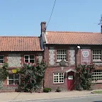
- Address
- The Street, Warham
- Website
- https://warhamhorseshoes.co.uk/
An absolutely fascinating old pub dating back to the early 18th century. It retains its Steward and Patteson Brewery regalia and has a little serving hatch where ale is dispensed from barrels atop the bar. The rustic little rooms are adorned with pictures and curiosities with plain rustic wooden tables. A courtyard with an old well provides a great place to sit and look at the old curious that adorn the place. There is also a garden. BandB accommodation is provided next door in the old Post Office and traditional home cooked food is on offer at lunchtimes and evenings. Ales include Woodfordes and guest ales. This is what you really expect an ideal village pub to be. Highly recommended.
Absolute delight to visit. The Woodfordes Wherry was fresh and refreshing and the pub is what I expect an ideal village pub to be.
Carpenters Arms, Wighton View in OS Map | View in Google Map

- Address
- High Street, Wighton
- Website
- https://www.carpentersarmsnorfolk.co.uk/
The pub had a curious six day licence from the mid 19th century up until 1926 when the Red Lion closed and its full licence was transferred. The pub had a brief closure in the 1980's and reopened as the Sandpiper in 1984, reverting back to the Carpenters Arms in 1997. It closed once again in 2011 but reopened in September 2013.
This pub has a bar that is divided into two distinct areas. There are usually two ales on offer, Adnams Bitter and a guest ale. Food available
Pleasant and friendly service. We, at last, managed to get a pint of Woodfordes Once Bittern. This is a new copper-coloured ale that is spicy with a hint of citrus.
The Captain's Table, Wells-next-the-sea View in OS Map | View in Google Map

- Address
- Holkham Road, Wells-next-the-sea
This modern looking pub, located just along from the Quay, was constructed in 1967 on the site of a row of cottages that dated from the nineteenth century. The construction was to replace The Ship Inn, a pub that sat directly opposite on Glebe Road. The business and the name was transferred from the old premises and Watney Mann was granted the first licence.
The original Ship Inn, which dates from the 17th century, can still be seen in Glebe Road and today it is used as holiday accommodation and is aptly named as The Old Ship Inn. Its successor was renamed The Ark Royal in 1969 and retained this name until 2013 when it was refurbished and renamed to the Captains Table. This is now a child and dog friendly pub offering real ale and food.
Unfortunately the pub closed for business in 2016. Its future is uncertain.
More of a holiday makers bar but nothing wrong with the beer, Wherry hitting the spot after the warm days walk.
Features
Warham CampView in OS Map | View in Google Map
Situated between Warham and Wighton, just off the road and accessible via a path along the field edge is what is believed to be a Celtic iron age fort. This 2000 year old earthwork is composed of two massive circular banks and ditches constructed within a bend of the River Stiffkey. It is believed to have been built by the Iceni tribe although local tradition names the site as Danish Camp and tells that it was built by the Danes after they landed at Weybourne Hope. Legend states that the Saxons from Crabb's Castle at nearby Wighton once drove the Danes out of Warham Camp by poisoning the river.
Parts of the camp were excavated in 1914, and again in 1959, unearthing fragments of Iron Age pottery dated between 200 BC and the 1st century AD. The remains of a wooden fence and walkway were found on top of the inner bank, providing a protective path around the camp. Large amounts of Roman pottery and roof tiles have also been found indicating that the site was reused in the Roman period, and of the existence of other Roman settlements in the area.
References
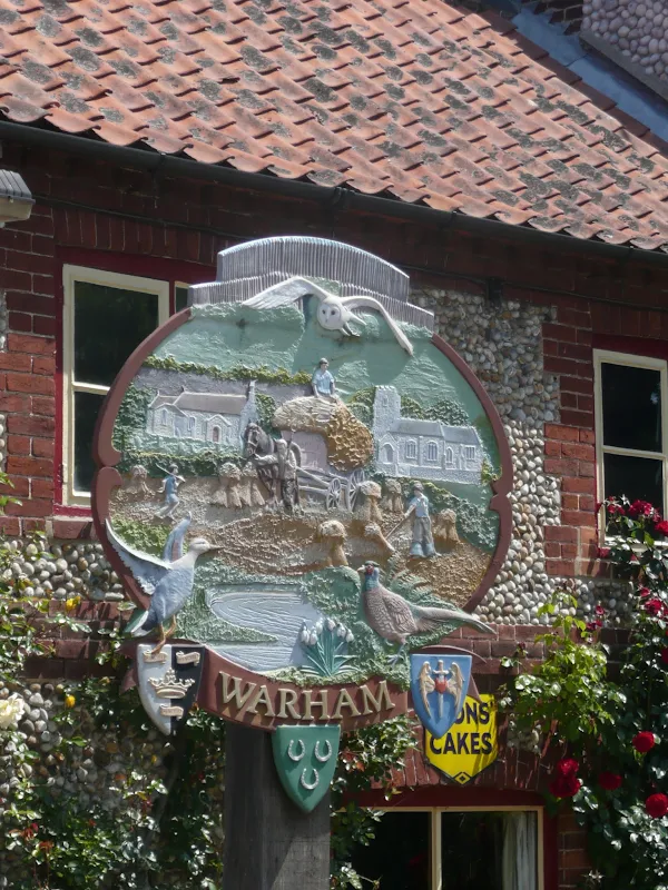
WarhamView in OS Map | View in Google Map
The curious thing about Warham is that despite its size, having only 79 households, this small village has two large medieval churches, All Saints near the village centre and St Mary Magdalen about 550 yd away. Originally, there were two ecclesiastical parishes here, but the two parishes were merged after the Reformation.
References
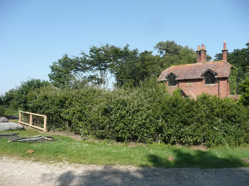
Wells-next-the-Sea railway stationView in OS Map | View in Google Map
Wells was first linked with the railway in 1857 when the Wells and Fakenham Railway opened a line to Fakenham, largely driven by the efforts of Lord Leicester and the directors of the railway company. They hoped that the railway, to be worked by the Eastern Counties Railway, would help reverse the declining fortunes of the town, whose inability to take ships of increasing size saw it overtaken by other ports. The decline continued notwithstanding the construction of a short branch line to Wells Harbour in 1860. In 1862, the Wells and Fakenham Railway became part of the Great Eastern Railway, a move which brought greater importance to the Wells line by providing a north-south connection with London's increasing food markets.
The West Norfolk Junction Railway was the next to come to Wells, in August 1866. The line came from Heacham on a 18½ mile single track aimed at exploiting the great arc of coastline between Hunstanton and Yarmouth. This line entered Wells on a sharp curve, turning through a full 180 degrees before converging with the Wells and Fakenham branch from Dereham for the final approach. West Norfolk services used the outer face of a sheltered wooden island platform to the south of the station, with the inner face for services to Dereham and Wymondham. The Dereham side was unusual in that there was a platform on either side of the train, allowing the passengers the choice of which side to alight from. Wells was a busy terminal station for almost 100 years, with a dozen or so passenger trains calling each day and goods trains from the harbour. The station eventually closed in 1964 when the line from Dereham to Wells closed to passenger traffic.
In 2007 the station building was a second-hand bookshop and pottery, with the site of the platforms an industrial estate known as Great Eastern Way. The old corn mill was used as a furniture warehouse, before being converted into flats. Part of the ground floor is occupied by Wells Antiques Centre and Glaven Veterinary Centre.
References
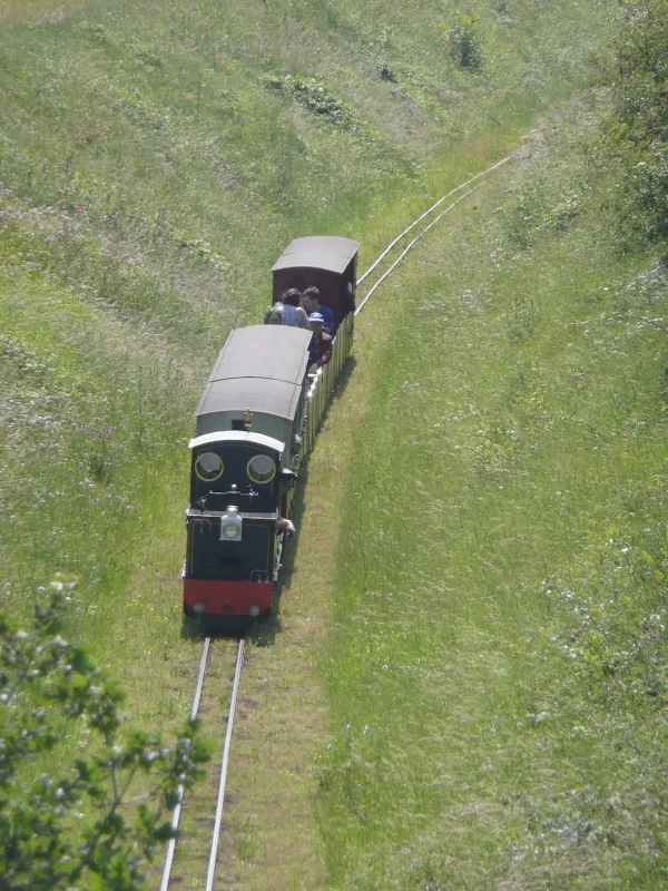
Wells and Walsingham Light RailwayView in OS Map | View in Google Map
The Wells and Walsingham Light Railway is a 10 1⁄4 inch narrow gauge heritage railway running between Wells and Walsingham along the former trackbed of the Wymondham to Wells branch line. The 4 mile line is the longest narrow gauge railway in the world.
The rebuilding of the line started in 1979 and a public service was finally launched on 6 April 1982 with the first train being hauled by the 0-6-0 side tank steam engine named Pilgrim. Pilgrim hauled trains until 1987 when the 2-6-0+0-6-2 Garratt locomotive Norfolk Hero came into service. The railway currently operate three steam locomotives and two diesels.
References
Image Gallery


Route Validation Cards
Validation Date - 2011-07-03
- Time of Walk: 10:00 to 17:30
- Validators: Griffmonster, Kat
- Weather Conditions: Very warm day, plenty of sunshine
- Notes: Initial route undertaken
Summary of Document Changes
Last Updated: 2026-04-20
- 2011-08-07 : initial publication
- 2013-12-29 : Added in references for Warham Camp
- 2018-11-22 : Adjusted route to keep off the road out of Wells
- 2021-03-17 : Update website improvements and removal of ViewRanger reliance
- 2021-12-01 : Removal of ViewRanger links due to its imminent demise
- 2026-01-12 : Major website update with all walks recast to the new format


1 comments:
great read
Post a Comment