A Walk around Suffolk's Minsmere Bird Reserve
Monday, 16 February 2026
|
3 comments
|
![]()

A 10 mile circular walk through the Suffolk Coastal Area of Outstanding Natural Beauty taking in Sizewell and the Minsmere Bird Reserve
One does not have to have an enthusiasm for ornithology to enjoy this walk. The natural surroundings of marshland and heathland are enough to inspire everyone and there is a lot of associated history along this route which dates back to the 12th century when Leiston Abbey once occupied an island in the marshes. Note that charges apply to the Minsmere section.

PLEASE NOTE: The section from the beach via the Minsmere North Wall and visitor centre, then through the woods via Island Mere is not a public right of way. Charges apply to use this section. RSPB members are free, but are asked to report to the visitor centre and show their membership cards for a permit. Charges for non members can be found on the Minsmere website. Non members can join on arrival. It is also important to emphasise that no dogs are allowed on this section of the walk, except assistance dogs. For dog walkers, or those not wishing to pay, please continue north along the beach to Dunwich Heath National Trust, then follow the path inland across the heath and through the woods, crossing the RSPB Minsmere entrance road along the bridleway and returning to the walk described here shortly before Eastbridge. This would add about 1.5 miles to the distance. Full details of visiting RSPB Minsmere are at www.rspb.org.uk/minsmere.
Walk Statistics
- Start location: Leiston
- Distance: miles ( km)
- Total Gain: ft ( metre)
- Total Descent: ft ( metre)
- Min Height: ft ( metre)
- Max Height: ft ( metre)
- Est. Walk Time:
- Walk type: Circular
- Walk Grade: Easy
- Terrain: Footpaths with some road walking
- Obstacles: The section from Minsmere through Eastbridge is on a country lane. Although this single track road is not particularly busy there are cars heading down to Minsmere and caution should be taken along this section. The section from Eastbridge back into Leiston is past some of the constriction area used by Sizewell C and caution should be taken due to the many HGVs that will be in this area. The alternative is to leave Eastbridge by Bakers Hill, then at Flash Corner crossroads turn left onto Potters Street. At the end cross the B1122 into the field and follow the diagonal path through to Leiston Abbey. It should also be noted that the paths through Minsmere are part of the RSPB reserve and are not public footpaths. All visitors should report to the visitor centre where RSPB members are requested to show their cards and a charge is applicable for non-members. No dogs are allowed on this section. The alternative route that does not go through the reserve is depicted on the maps.

Maps
The following maps and services can assist in navigating this route. There are links to printed maps and links to downloadable GPX route data for importing into navigational software and apps.
- Ordnance Survey Explorer Map
- OS Explorer 212 - Woodbridge & Saxmundham
- GPX Route File
Walk Notes
Mention Minsmere and the most likely thought that comes to mind is the Bird Reserve and twitchers with huge lenses and tripods and binoculars. But it is so much more than just a Bird Reserve, this area has an intriguing history as well as a natural beauty. Therefore one does not need to be a budding ornithologist to appreciate this landscape.
There are many paths across Minsmere and these are illustrated on a map of the reserve referenced on the RSPB Minsmere website. It should be noted that these routes are all part of the RSPB Minsmere reserve and as such are not designated public footpaths. The reserve is open from dawn to dusk each day except Christmas Day and Boxing Day and all visitors are requested to report at the visitor centre where RSPB members will be requested to show their membership card and a charge will be levied for non-members. Dogs are not allowed on any of the RSPB Minsmere section of this walk.
The walk through the reserve is highly recommended and more time can be spent exploring this exquisite environment. For those purely interested in walking and who do not want to incur the charges, or for those with dogs an alternative route is to keep to the coast path up to Dunwich Heath from where the Sandlings Footpath can be followed around the perimeter of the reserve rejoining the route described here close to Eastbrige. A shorter alternative is to use the public footpath alongside the Sluice which follows the river and emerges at Eastbridge village.
It was from an evenings conversation with an old timer in Leiston that prompted this particular walk. He had related the fact that Minsmere once had houses along the seafront and even a cafe complete with a veranda. To top it all his old mother used to live in one of them as a child and he had photographic evidence to prove his point. He told me that she had to walk to school in Theberton each day along the old track up to Eastbridge then by the lanes through to the village. This is a pleasant little stroll that is frequented by many tourists during the spring and summer months and one which I have undertaken on hundreds of occasions. But to do this each day during the depths of winter, no matter what the weather and in the dark must have been quite a endurance.
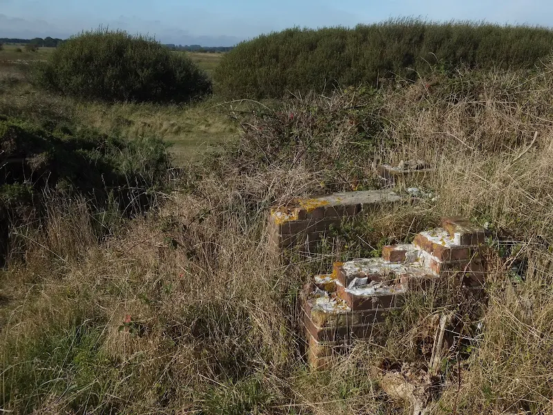
Despite on-line research and reading old books there is little mention of these cottages. Even records and websites dedicated to the relics from wartime fortifications and defences fail to mention either the cottages or when they were demolished. More recently, an article appeared in the Autumn 2013 edition of the Leiston Town Newsletterwhich revealed that the cottages were evacuated during the war when they were used for target practice by the military and then demolished shortly after the end of the war.
Having walked the seafront dunes between Sizewell and Dunwich hundreds of times I had never noticed any evidence of any buildings but on this occasion, rummaging through the brambles and undergrowth, the decaying evidence soon presented itself. Brick walls. Pebble dashed footings of where the cottages once stood. Clear and positive remains to long gone structures. A delight to find and interesting to see the many walkers and twitchers walking by without the slightest inkling that the remains of this fabled hamlet of Minsmere lay before them.
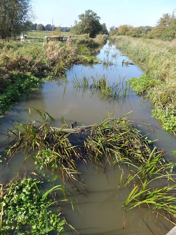
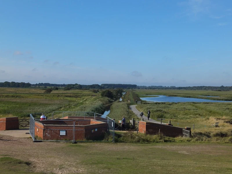
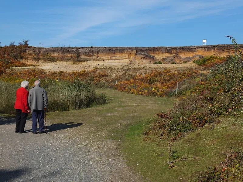
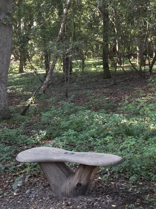
In all the years of walking this coastline, I can honestly say that this was the first time I had ventured through the bird reserve. The usual route is either to follow the New Cut up to Eastbridge or take the Sandlings route around the perimeter of the reserve from Dunwich Heath. We entered the reserve along the new North Sea Wall which has been built to protect the main part of the marshes after the northern section had been repeatedly breached by winter storms. There was plenty of people about and not just the stereotypical twitcher, there were couples and groups just taking in the early autumn sunshine and the views. The area around the visitor centre was busy, inundated with daytrippers. Beyond this, especially at the reserves furthest reaches, there was few people which is how I like it. The Island Mere Walk through to the Eastbridge road is a contrasting walk to the open marshy landscapes. This navigates through broad-leaf woodland predominantly made up of oak. The sunlight glistened through the canopy and presented some amazing colours through the foliage.
Directions
A simple walk using existing footpaths, lanes and tracks all of which are well defined.
Leiston to Minsmere
Walk down Red House Lane on the southern edge of Leiston and continue beyond the housing onto grimseys Lane and across the field at the end to emerge onto the Sizewell Road at Half Way Houses. Follow the road to Sizewell then head northwards past the Power Station. Continue to the Sluice. Between the main landward side track and the beach before the sluice are the remains of the old cottages that once made up the hamlet of Minsmere. Keep to the dunes beyond the sluice and enter the reserve where the Minsmere North Seawall heads inland. It should also be noted that the paths through Minsmere are part of the reserve are not designated public footpaths. RSPB members can freely walk these paths whilst non-members are requested to make a small donation at the visitor centre which is located at the end of the North seawall.
Minsmere to Leiston
Take the path adjacent to the visitor centre following the signs for the Island Mere Walk. This follows a trail through oak woodland that emerges onto the road at Scott's Hall. Turn left and follow the road through the trees to Eastbridge. This road can be fairly busy but the traffic is calmed with numerous speed bumps. Continue onward from Eastbridge, following the road to the Leiston road junction. Turn left, cross the road to the pavement and continue into Leiston
Minsmere to Eastbridge - Alternative Route via Docras Ditch for Dog Walkers without incurring RSPB Minsmere charges
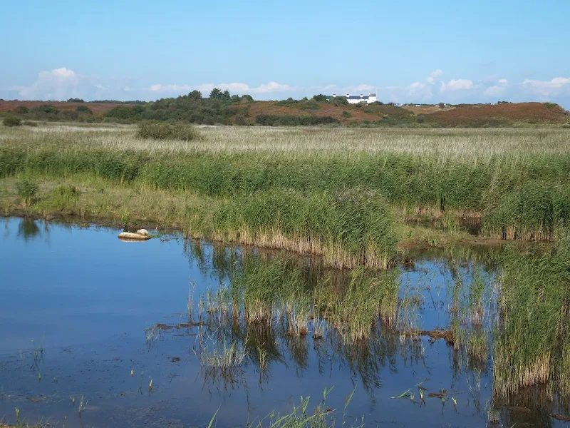
Continue northwards from Minsmere sluice up to Dunwich Heath. The path climbs the cliff onto the heathland. Keep to the main path going behind the distinctive white Coastguard cottages and head towards the toilet block. From here a path leads off inland which is marked with the distinctive Sandlings Long Distance Footpath waymarkers. Keep to this path across the heathland and into the woods. Eventually it junctions with a track. Turn left and follow the track to the road. Cross the road and follow the path along the hedge to the grassed fields. This eventually leads down through more woodland onto the Eastbridge road. Continue straight ahead and follow the road into Eastbridge.
Minsmere to Eastbridge - Alternative Route via New Cut for Dog Walkers without incurring RSPB Minsmere charges
Take the public footpath that leads alongside the Sizewell side of the river. This footpath soon leaves the rivers edge and navigates up to Eastbridge. The Eels Foot pub can be found turning right and is a short distance down the road. The route continues to Leiston by turning left at this road.
Alternative Route - Start and end at Sizewell
An alternative route is to start and end at Sizewell. Follow the directions above, then beyond Eastbridge take the track on the left that is waymarked with the Sandlings Path. Keep to this through to Kenton Hills woods, then across Sizewell Belts and Leiston Common to return back to Sizewell
Features
MinsmereView in OS Map | View in Google Map
The area now known as Minsmere was recorded in the Domesday Book of 1086 as Menesmara or Milsemere citing that it had six households headed by freemen with one plough team. The settlement was based around the estuary to the Minsmere River and there is even a 1237 description of Minsmere being a port. To the south of the estuary was the setting for Leiston Abbey which was constructed in the early 1180's on an island that was connected to the mainland of Leiston by a causeway. However, constant flooding caused by the sea surges forced the Premonstratensian canons to move the Abbey inland to Leiston. All that remained was a small Chapel dedicated to St Mary that was constructed after the move, located within what would have been the main Abbey church. This was used up until the dissolution of the monasteries in the 16th century. The ruins of this chapel still remain and a path leads to them from both the north side and the west side of the hill upon which it stands..
The course of the Minsmere river has changed over the centuries, the present course, originally known as Huntingsfields Ditch and later as the New Cut was constructed as part of the drainage work carried out as part of the Minsmere Level Drainage Act 1810. Prior to this its course followed a natural winding route to the north of the present New Cut with its outfall to the sea near Coney Hill, just south of the Minsmere Cliffs and Dunwich Heath. This outfall was controlled by a wooden sluice. Further back in time, when the Abbey was in use, the course was closer to today's river, with the outfall somewhere around the present sluice area.
It is interesting to note that the Minsmere river takes its name from this area rather than the name of one of its tributaries such as the Yox or Gull. The river rises in Ubbeston near Peasenhall where it is known as the Yox. It then passes through Yoxford at which point it becomes known as the Minsmere River.
Minsmere village is thought to have been on the north bank of the estuary and is recorded in the Domeday book as being a small manor with six households and one plough team, held by Roger Bigot. The village is later described as consisting of about 10 houses and a small church, which was also flooded around the same time as the Abbey was inundated causing its relocation. The village was subsequently lost to the sea by the 16th century. There is evidence that peat cutting was performed at Minsmere as early as the 12th century.
During the 17th century the Minsmere estuary became blocked by a shingle spit which resulted in a poorly drained fen fed by the Minsmere River and an unnamed watercourse from Leiston. This swampy and marshy ground that was formed from this blocked access and became the haven for smugglers during the 18th century. Sizewell Gap was a popular landing place for the illicit cargo which was then whisked away into hiding, a lot of it finding its way to secreted locations on the Minsmere Levels. The smugglers tracks were then obliterated by local shepherds who would drive their flocks across the routes to disguise the locations of the booty. Only the local population would know the way across this marshland and it was said the only method of passage was to jump from tussock to tussock.
In 1808 Anthony Bower, a Lincoln surveyor and engineer reported on the potential drainage of Minsmere Level which he presented to Parliament the following year. The report recommended replacing the wooden sluice which was in a very bad state of upkeep and putting in a new cut for the river that would straighten its course all the way from Reckford Bridge to the sluice. This resulted in the passing of an Act of Parliament entitled Minsmere Level Drainage Act 1810 which was given Royal Assent 18th May 1810. This set out the authority:
to drain level of Marshes and Fen Lands called or known by the name of the Minsmere level within the several Parishes of Leiston, with the Hamlet of Sizewell, Theberton, Dunwich, Westleton and Middleton cum Fordley, in the County of Suffolk.The report also recommended using the spoil from the new cut to build up the shoreline defences which were regularly breached. Despite this undertaking, in the winter of 1828 a storm breached the defence and flooded the level to a depth of 2-4 foot. The breach was shored up but the Level has been regularly breached by tidal surges and continues to be inundated during winter storms to this very day.
Following the drainage act was the passing of 'The Leiston and Theberton Enclosure Act' which divided the level into three distinct areas, Minsmere Level East, Minsmere Level West and Leiston. The eastern area had already been enclosed by 1786 and had dykes and sea walls and included a small broad just north of the Chapel ruins which survived until 1813. During the years of 1812/3 a Main Drain was constructed together with embankments and a sluice to connect the rivers to the sea, the iron outfall pipe being provided by Garrets of Leiston.
In 1846 Garrets of Leiston were contracted to build machinery powered by three powerful steam engines to provide better drainage of the Minsmere Level. Drainage was assisted by four windmills, one of which was eventually rescued and restored by the Suffolk Mills Group in 1977 and is now part of the Museum of East Anglian Life in Stowmarket.
What is worthy of note is an extract from the 1870 travelogue of the Norfolk and Suffolk coast by William Alfred Dutt where he mentions the Minsmere River at the haven:
On its banks there was probably a small fishing hamlet; for there is an isolated cluster of old dilapidated cottages near the sluice, some of which are still inhabited.. Certainly there are local memories and stories of the people who lived in these cottages by the sea at Minsmere which is backed up by the brick and stone remains that lay hidden in brambles along the dunes. These seafront dunes used to be known as the Minsmere Benthills, though there is also a reference to these being locally known as the Pentlands. This is not thought to have any connection to the original Minsmere village but may have been the original sluice keepers cottage.

Despite the description of the hamlet being in a dilapidated condition, this certainly was not the case during the first half of the 20th century. An article that appeared in the Autumn 2013 edition of the Leiston Town Newsletter gave a little more insight into this old hamlet, where Councillor Colin Ginger recounts the memories of his family who lived at the cottage. The article includes three old pictures, one of the Sluice Cottage area and the other two of a cafe that once stood just south of the Minsmere cliffs. Councillor Ginger further describes how his grandparents had lived at Minsmere at The Sluice Cottage, where his grandfather was in charge of the sluice operations. The cafe was owned by a Mr Sprunt of Westleton between the war years and it had burnt down and was then rebuilt although no dates are given for this event. The sluice hamlet was evacuated during WWII when the houses were used as target practice by the military. Shortly after the end of the war the buildings were demolished.
The 19th century drainage of Minsmere enabled the land to be used for agricultural purposes which lasted up until the second world war when the decision was taken in June 1940 to flood the area as a defence against the possibility of invading tanks. In addition, the New Cut bank was wired and mined and a pillbox built into the ruins of the old chapel. Along the beach were set numerous concrete cubes which would also act as anti tank defences, many of which remain in position to this day. Part of marshes was also designated as the Leiston battle training Area in 1943.
The flooding at the start of the war resulted in reed beds becoming firmly established. In 1947 the bird reserve was established and the RSPB leased around 1500 acres from the Ogilvie family who then owned the land. Eventually the land was purchased outright in 1977 with further land being purchased in subsequent years.
Today Minsmere reserve is made up of 0.69 square miles of reed habitat as well as areas of open water, lowland hearth, grassland, scrub, woodland, dune and shingle. The area has become an important breeding, roosting and feeding site for many bird species with over 100 resident species and around a further 240 migratory visitor species. The site is managed with controlled water levels to prevent drought and a seven year rotation of reed cutting. Grazing animals are employed to prevent expansion of scrubland
References
Links and Bibliography:
- Archeology of the Suffolk Coast - a report made for Suffolk County Council
- Biographical Dictionary of Civil Engineers Vol 1 1500-1830
- History, Gazetteer, and Directory of Suffolk 1855, William White
- Cotswold Archaeology Report, Leiston Abbey and Minsmere: A FiveYear Community Based Archaeological Excavation Volume 1
- Coastal Processes and Morphological Change in the Dunwich-Sizewell Area, Suffolk, UK, Kenneth Pye and Simon J. Blott
Image Gallery


Route Validation Cards
Validation Date - 2012-10-07
- Time of Walk: 10:30 to 16:00
- Validators: Griffmonster, Kat
- Weather Conditions: Bright sunny day with clear blue skies
- Notes: Initial route undertaken
Validation Date - 2026-01-31
- Time of Walk: 06:30 - 10:00
- Validators: Griff
- Conditions: Cold, bright and sunny
- Notes: All paths looking good. A frequent wander for myself
Summary of Document Changes
Last Updated: 2026-04-20
- 2013-03-10 : Initial publication
- 2013-08-16 : Add in clarification on the access to Minsmere
- 2013-12-03 : Include references from Leiston Town Newsletter article on Minsmere Sluice Cottage, pp15-16
- 2019-01-02 : General website update plus links to alternative walks
- 2021-03-17 : Update website improvements and removal of ViewRanger reliance
- 2021-12-01 : Removal of ViewRanger links due to its imminent demise
- 2026-01-12 : Major website update with all walks recast to the new format
- 2026-02-16 : Rework the feature and add in new references and details


3 comments:
Hey Griff,
My name is Martyn Addison and I represent The Great Outdoors Superstore Website Marketing at Visualsoft UK.
Really love your work here, you have an impressive collection of Great British walks which you have built up and continue to grow. If you would ever consider working with TGOS online then please feel free to email me at:
martyn [dot] addison [@] visualsoft [dot] co [dot] uk
Kind Regards,
Martyn
This is a fantastic walk - one of the best on the Suffolk Coast – and highly recommended at any time of year. However do be aware that the path from the beach through the RSPB reserve, along the North Seawall via the visitor centre to the Island Mere, is not a public footpath. We called in at the centre and had a very welcome cuppa (before heading for the Eel's Foot at Eastbridge - great pub!) and a browse round their shop, which is really good. The RSPB staff were very welcoming and pointed out the path (they didnt know your online walk, Griff) but it's fair to know that the reserve makes a small charge to non-members to use the paths if you're not a RSPB member. As it happens we are...our friends wern't (but joined!) They siad you can make a donation if you;re jsut walking through but it is actually worth joing up if you want to do something more for nature, wildlife and the countryside - and you can go through anytime then and to other reserves, so all good. Good idea to put this on the direcdtions, Griff, for other folk.
Thanks for pointing this out Tom. I will add this into the walk details.
Post a Comment