Nar Valley Way - Narborough to Dereham
Saturday, 29 December 2018
|
1 comment
|
![]()

A 22 mile walk along the Nar Valley Way from Narborough to Dereham
This route is full of historic features including ruins of priories and castles as well as magnificent halls and watermills. The walk provides a varied landscape with woodland trails, riverside paths and saunters across open fields of this pleasant Norfolk countryside. Although a lengthy section of the Nar Valley Way there is plenty of time to accomplish the feat with late buses linking the two ends.

Walk Statistics
- Start location: Narborough
- End location: Dereham
- Distance: miles ( km)
- Total Gain: ft ( metre)
- Total Descent: ft ( metre)
- Min Height: ft ( metre)
- Max Height: ft ( metre)
- Est. Walk Time:
- Walk type: Linear
- Walk Grade: Lengthy hike but no challenges
- Terrain: Footpaths, tracks and country lanes. A little road walking
- Obstacles: The route changed on 2013 and current OS maps do not depict the present route - visit the Norfolk Trails website for full route details. Low bridge out of Narborough which involves stooping or crawling to get under. East of Litcham involves walking along a fairly busy road where there is no pavement.

Maps
The following maps and services can assist in navigating this route. There are links to printed maps and links to downloadable GPX route data for importing into navigational software and apps.
- Ordnance Survey Explorer Map
- OS Explorer 236 - King's Lynn, Downham Market & Swaffham
- Ordnance Survey Explorer Map
- OS Explorer 238 - Dereham & Aylsham
- GPX Route File
Accommodation
Pentney Park Camping and Caravan SiteView in OS Map | View in Google Map
- Website
- https://www.darwinescapes.co.uk/parks/norfolk-woods-resort-spa/
- Description
- Pleasant campsite set in a semi wooded area alongside the A47. Miniature railway runs through the site. Optional early arrival and late leaving rates. Unfortunately during late 2018 this site was taken over by holiday park operator Darwin Escapes and redeveloped as a luxury spa and resort with no touring pitches available.
Transport
First Group - Bus Service
- Service Details
- X1 - First Group X1 service Great Yarmouth to Peterborough linking Acle Norwich, Dereham, Kings Lynn
- Timetable
- First Group (Norfolk and Suffolk) Website
Walk Notes
The 22 miles of this section may seem a little lengthy but this is the distance between the only linking bus service. There is very little in the way of public transport around the villages between Narborough and Dereham and the route veers away from the main A47, which the X1 bus service uses, until the Wensum way can be used to walk down to Dereham. The only alternative to hiking the full distance is to either undertake a series of shorter circular walks or, as a group of walkers, use two cars to link between specific start and end points.
Even so, 22 miles is a good distance for a full days walk for those who are used to walking, and with late buses back from Dereham there is no need to rush the route. One surprise was that the single fare between Dereham and Narborough was £6 which seemed a lot of money for the distance but it is nonetheless good value for a days walking!
A Bridge to be Wary of
Bridges are not a rare encounter on a walk, therefore encountering the first bridge along this route was not a surprise. A short distance from where the path heads out of Narborough is this particular bridge that carries the busy A47 trunk road and both the footpath and the River Nar pass underneath this. The road above is a modern highway which forms the bypass to the village of Narborough and as such this overpass is a typical concrete based construction with vertical walls and a span of steel and concrete. The footpath below is a semi-firm surface with a tube railed fence to guard against falling into the river. The concrete, as with all modern conurbations, is strewn with graffiti which lacks charisma, thought or uniqueness. It is remarkable that such a small place like Narborough has a graffiti artist. If the authorities even wanted to charge the culprit it must would be easy to locate them as he or she must be the only graffiti artist in the village!
What makes this bridge worth the effort of verbally describing is its size, or more specifically its headroom. Most bridges that traverse footpaths are accommodating for the size of the average walker to comfortable pass under. At 6 foot in height, I may be a little taller than the average Briton so I cant argue if I have to stoop a little. But Kat is somewhat smaller than I and she also had to stoop to enter the confines of the bridge span. This initially was merely a slight inconvenience but the road above is on a slight curve and as such has a camber which dips away from Narborough. The consequence of this camber is that the headroom decreases as one walks under the bridge. This was not a slight difference in headroom but a reduction in height that involved me having to crawl the end few feet on hands and knees.
So what could have been the cause of this lack of headroom? Maybe the road was across a marshy area and had slowly sunk after it was built although one would have thought the designers had surveyed the area adequately before contemplating the construction. There was no evidence of any marshiness so probably not a good theory. Maybe the builders had misinterpreted the plans and got their measurements mixed up.... although such incompetence is not unheard of one would have expected this to have been picked up before now and accommodations made to allow for this miscalculation.
My best theory is that the architect of this modern construction was a dwarf with a chip on his or her shoulder and this was their method of getting their own back on us six footers. It was their retaliation for a life growing up to taunts such as 'I'm having a pint, do you want a short?' and 'whats the weather like down there' as well as their constant comparison to characters from Lord of the Rings. As I crawled from the dusty confines I could hear the sniggers of the vertical challenged architect ringing in my mind as another six footer was inconvenienced by his/her fiendish construction. But the joke was on them because I was laughing louder. Such challenges as this bridge do bring a comical element to a walk. It was fun. It was a laugh.
Many Features
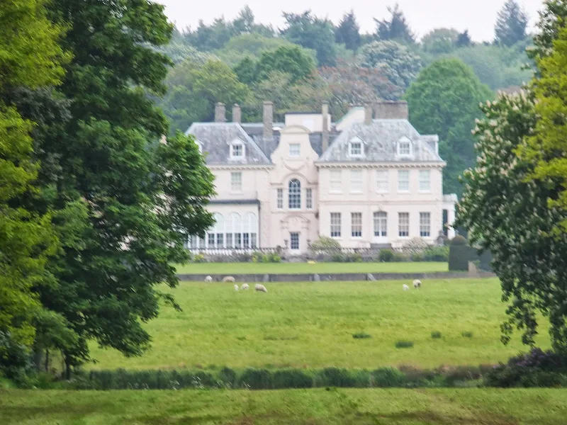
The walk continues through the Bradmoor Plantation woodland up to Bradmoor Hill. There isn't any noticeable incline but there is a little revelation when the woodland makes way to a long thin clearing. On the left is a brick shelter, open at the front and with decorative columns looking elegant and distinctive in the woodland surroundings. To the right there is a view all the way down the hill to Narford Lake with Narford Hall just beyond. The construction on the left is a curiosity as I cant find anything out about this. My guess is that is purely a Victorian folly.
This is the first of many features that accompany this walk along with the most obvious and well known ones such as West Acre Priory, Castle Acre Priory and Castle Acre Castle but with so many miles to cover time only allows a brief perusal of each feature. Other sights are Lexham clock tower, Lexham Hall which appears down an grassed avenue amid the woodland that is bordered by the track to Litcham, Litcham Common, Mileham castle, and the Medieval village of Little Bittering.
Village Pubs
There are a few pubs along this route, and if one walked in the opposite direction the West Acre Stag and the Castle Acre Ostrich are both worthy historic inns that are worth the stop for. Unfortunately on this walk it was much too early for pub opening hours and a cup of tea in Barnfields cafe at Castle Acre was a worthy rest and refreshment. Next door to the cafe is the 18th century Albert Victor pub which was undergoing refurbishment. Unfortunately this marked the end of this building as a hostelry and it has since been converted into a private house. Both the Albert Victor and the Ostrich were visited when walking the Peddars Way in 2008 and are detailed in The Peddars Way - Watton to Castle Acre
The only pub beyond Castle Acre is at Litcham. We had planned to arrive at lunchtime and got there as planned. With 20 ales regularly on we could have stayed all day! The next pub is not until Gressenhall and by this time the miles were telling on the legs. There are not many practical stops and we were both looking forward to getting to this pub, to put our feet up for half an hour and take stock after a days walking before we ambled the last couple of miles into Dereham. The pub was marked on the OS map and it appeared to be on the route of the Nar Valley Way so we would not need to detour around the village.
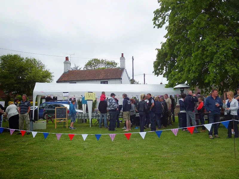
On entering the village we could not help but notice the abundance of people as we walked down the long straight road into the village. In addition was the odd scarecrow propped up by houses or at the edge of driveways. Groups of people were heading both out and into the village. Youngsters. Families. Aged couples hobbling along. I know it was a Saturday but even so one doesnt expect such a profuseness of people in a village. The road met the centre of the village with a sharp turn left and according to the OS map a pub on the right. Straight ahead was a green which appeared to have some event taking place on it judging by the bunting. This was obviously the source of the noise that would often be caught on the breezes. As we drew closer it was obviously a village fete. But the sight of the pub adjacent to the green was something that dampened the spirit. Windows that were boarded up. A sorry looking building. Closed for business. Then a thought occurred: A summer fete. And with a summer fetes there is always the possibility of a beer tent. It could be seen that there was many people heading away from this event which brought the conclusion that it was drawing to an end and gave a little extra impetus to hurry the weary legs towards the green in search of a beer tent. There wasn't a beer tent as such but there was a stall serving beer. Two barrels set behind the pedestal table and were constantly being drawn upon by the bar persons. Real ale. It was Wolfs Coyote or nothing. Wolfs Coyote is a well refreshing beer and at only £2.50 a pint who could want more. Heaven.
The Nar Valley Way used to end at Gressenhall. But in 2013 Norfolk Council created the new Wensum Way linking the end of the Nar Valley Way to Lenwade on the Marriotts Way to make up the Cross-Norfolk Trail linking Kings Lynn and Great Yarmouth. What had not been expected is that the Wensum Way has a link down into Dereham. Although we had planned to walk along the same footpaths it was comforting to know that this was part of the Wensum Way.
Directions
The Nar Valley Way is a long distance trail linking Kings Lynn and Dereham. This forms part of the new Cross Norfolk Trail. The route changed on 2013 and current OS maps do not depict the present route - visit the Norfolk Trails website for full route details
The path leads out of Narborough opposite the mill. This is a footpath alongside the River Nar and leads under the A47. The bridge is low and average sized person will need to stoop to get under this. The path leads out into woodland of the Bradmoor Plantation .Keep to the main route following the waymarkers, roughly following the river before it leads away and up a slight incline. Where it meets another path, turn right through the trees and across an avenue of grass with Narford Hall in the distance on the right. Walk straight on and out onto the road. Turn left, then right onto a track which leads down to West Acre.
Keep straight ahead on the road through West Acre until the road junctions at The Stag pub. Take the lane on the left which leads down to a ford across the river with a footbridge by its side. Cross the footbridge and continue up the road until it meets a crossroads. Turn left down towards anothe ford. Before reaching the river there is a path on the right. Take this which leads to a footbridge across the river and onto a track through the woodland and onto Castle Acre Common. The track meets a lane at the end of the common, turn right along the lane which leads into Castle Acre village. Turn right at the first junction in the village and follow the road around past the Priory and Church. Turn right through the flint archway and down Bailey Street. At the bottom of the hill turn left onto a footpath which leads past the perimeter of the Castle.
There is open pasture beyond the castle. This covers a hillside with little markers to indicate the way ahead. This needs to be crosse diagonally almost grazing past the ege of Castle Acre housing on the left. This will lead to a gate onto the road opposite a lane. Continue along this lane which turns to atrack and leads onto the road into Newton. Follow the road over the river at the Mill then take the track down the side of the Mill. This leads onto a track up to the main road. Cross the road and continue straight ahead. Keep to the lane on the left, ignoring the markings on the OS map for the Nar Valley Way. A new waymarker points down this new route. This is a very quiet country lane and leads through to East Lexham where it junctions with another lane with a little green centred with a round shelter with seats. Turn right at the green and continue out of LExham until a waymarker point off to the left following a track. This leads down alongside some woodland and then through some more woods. Keep to the main track and when on the opposite side of the woods the track turns right up the hill then left. Just before reaching the road, turn left and folow the footpath across the field and then alongside the woodland at the far edge. This then leads into the woods which are part of Litcham Common, emerging at the edge of Litcham Village. The pub is up the hill, past the church and opposite the village green.
The trail leaves Litcham by taking a right turn before the church. Follow the road around the bend and there is a marker pointing down a track on the right. Keep to this until a marker points up the hill to the road. This is the B1145 and can be fairly busy so caution should be taken. This can be followed through to Mileham but the official route leads off of the road before the layby on the left. A footpath leads across the fields, across a road then alongside some woodland. This then returns back along the opposite side of the woods and across the fields to Mileham. Turn left at the road and follow this around and left back onto the B1145. There are pavements through the village.
Keep to the road all the way through the village until there is a track on the right by the Garden Nursery. Take this track to the end, then diagonally cross the fields to the woods at the bottom of the hill. The path emerges onto the road and continues up the hill and left at the junction. Folow this lane past Bittering, taking the right by the houses then left at the next junction. Keep to this for a mile until a track leads off on the right which leads to Gressenhall. Turn left as it emerges onto the road, the right at the cross roads. Follow the road around to the left at the village green and continue out of Gressenhall.
When the road jucntions with the main road, take the right downt he hill and across the stream. There is a track on the right marked as the Wensum Way. Keep to this which leads across the fields and out onto a road junction. Continue straight ahead into Dereham
Pubs
Bull Inn, Litcham View in OS Map | View in Google Map

- Address
- Church Street, Litcham
- Website
- www.thelitchambull.co.uk/
A charming traditional coaching Inn dating from the early 17th century although the foundations date from the middle of the 14th century which makes it the second oldest Inn in Norfolk. It has been the centre of village life in Litcham for centuries and once hosted annual fairs, bean feasts and venison feasts whilst also being the local magistrate's court until the late 1700's.
The well stocked bar boasts twenty or more different cask ales from smaller breweries either local or national which are on tap all of the time. Food is available and ranges from sandwiches, pannini's and light lunches through to a full a la carte menu plus a daily specials board.
I have to admit that I did not expect to be greeted by a selection of 20 ales when I entered this quiet village pub. It was a difficult choice with local selections from Panther, Ole Slewfoot and Wolf breweries as well as nationals such as Charles Wells. I eventually opted for the First Lightening from Rugbys Atomic brewery. A pale 4.6% ale using lager hops that was refreshingly bitter.
The pub is a delight to visit and if it was not for the extent of the mileage that had to be undertaken we would have most certainly stayed for another pint.
Romany Rye, East Dereham View in OS Map | View in Google Map

- Address
- Church Street, East Dereham
- Website
- https://www.jdwetherspoon.com/pubs/all-pubs/england/norfolk/the-romany-rye-dereham
Named after the book The Romany Rye by author George Henry Borrow who was born in the town in 1803. The 1960's building, originally the Pheonix Hotel, was bought by J D Wetherspoon in 2011 and underwent a complete redevelopment to provide a modern hotel with the usual Wetherspoon varied menus of reasonably priced food and selection of local and notional ales together with a local theme throughout the bars.
Although not a huge selection of ale there was a sufficient choice and a pint of Old Hooky was a worthy contender to soothe some aching legs. The steak dinner which included a pint of ale for the price was excellent value.
Features
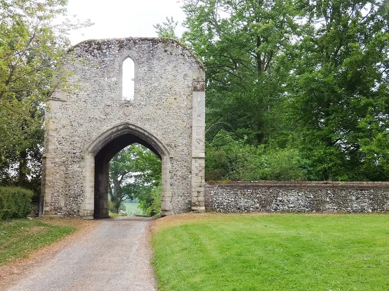
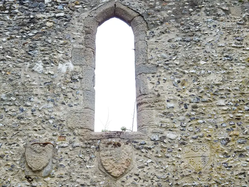
West Acre Church and PrioryView in OS Map | View in Google Map
The medieval priory was built in the early 12th century by the Augustinian Order of monks and continued in use up until the mid 16th century when it suffered under the dissolution of the monsastries by Henry VIII.
Although now in ruins there are the remains of the priory church, cloisters, chapter house and gatehouse as well as extensive earthworks adorning the site. The church was cruciform, aisles being inserted in the nave in the 14th century.
To the east of the gatehouse is the church of All Saints. The present building dates from the 17th century when it was remodelled from an earlier medieval church. Probably the most prominent feature when first viewing the church is the tower clock which has its numbers substituted with the words Watch and Pray.
References
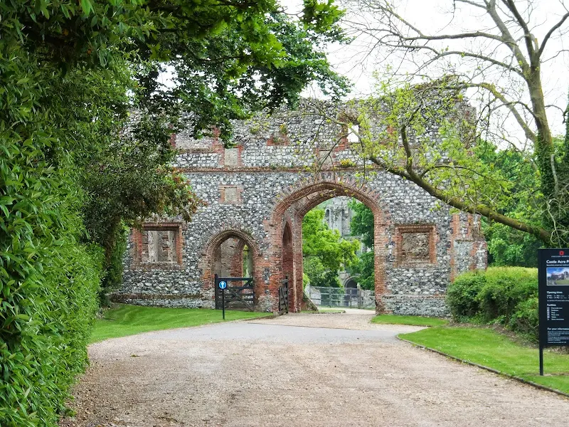
Castle acre PrioryView in OS Map | View in Google Map
William de Warenne the son the 1st Earl of Surrey founded Castle acre Priory in 1089. Originally the priory was sited within the walls of Castle Acre Castle, but this proved too small and inconvenient for the monks and the priory was relocated to the present site about one year later. The priory was dissolved in 1537 under Henry VIII, when the King gave the dissolved priory to the Duke of Norfolk complete with its estates and the remaining monks were turned out. The estates eventually passed to Sir Edward Coke, whose descendant, the Earl of Leicester now owns the ruins and Castle Acre Castle. The present day ruins are impressive with the great west front of the building almost complete, and the prior's lodging in a similar condition. The priory is now in the care of English Heritage.
References
Castle acre CastleView in OS Map | View in Google Map
Castle Acre Castle was founded soon after the Norman Conquest of 1066 by William de Warenne, the first Earl of Surrey, as his most important estate in Norfolk and is strategically placed at the point where the Peddars Way crosses the River Nar. The castle was of motte-and-bailey construction; on the summit of the motte was the residence of the owner, and the last refuge in the event of an attack. The bailey below contained living quarters, stores and workshops. A strong curtain wall with wall walks surrounds the motte summit, and a lesser wall tops the bailey banks. It is local legend that Cromwell is said to have stood his guns on nearby Winchester Hill, to the east of the castle, in order to demolish the structure. An old rhyme says "Had it not been for Winchester Hill, Castle Acre Castle would ha' stood still". The Castle is now in the care of English Heritage.
References
Newton WatermillView in OS Map | View in Google Map
Newton Mill is the first water mill along the course of the river Nar. The site is mentioned in the Domesday Book as well as being recorded on Fadens map of 1797 from when records detail the mills ownership up to the present day. The mill was built in brick with a pantiled roof, and a mill house, built with stone from a ruined priory, was attached. The mill was then later enlarged, resulting in it having a different roof line to the house. The mill was restored in 1972, and the mill house was demolished in 1977 to be replaced by a new house in the 1990s. Most of the machinery, including the wheel, are still in place, although not operational
References
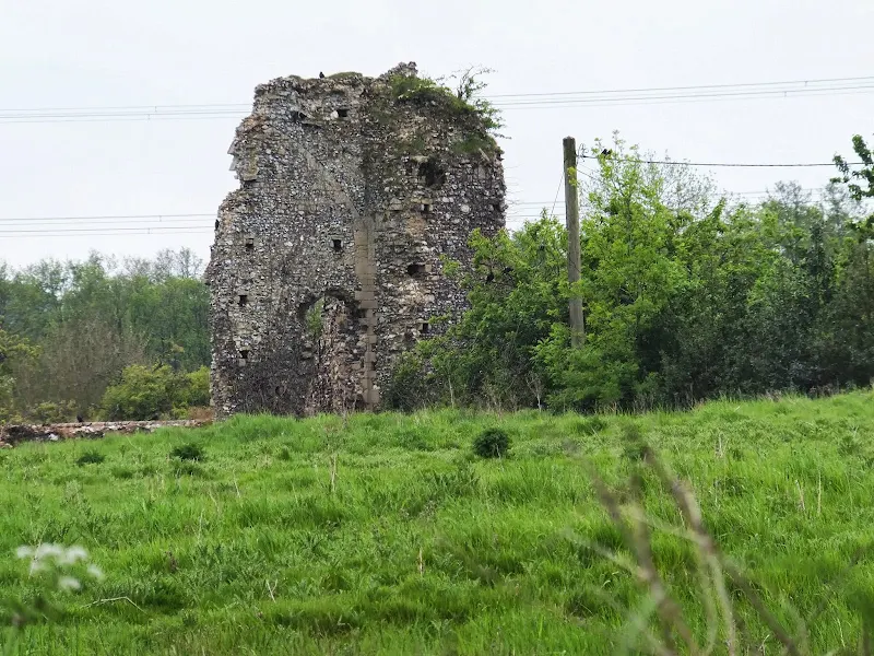
Mileham CastleView in OS Map | View in Google Map
The village of Mileham stands on an ancient east to west route through Norfolk, now the present day B1145. Such a position may indicate that the castle was connected to generating income from tolls on travellers. The castle dates from the 12th century and was attached to a large wooded deer park to the south and it was in use up to the 14th century when it was abandoned. All that remains today is the motte with the base where the original 50 foot square tower stood, together with the outer baileys.
References
Castle acre CastleView in OS Map | View in Google Map
Castle Acre Castle was founded soon after the Norman Conquest of 1066 by William de Warenne, the first Earl of Surrey, as his most important estate in Norfolk and is strategically placed at the point where the Peddars Way crosses the River Nar. The castle was of motte-and-bailey construction; on the summit of the motte was the residence of the owner, and the last refuge in the event of an attack. The bailey below contained living quarters, stores and workshops. A strong curtain wall with wall walks surrounds the motte summit, and a lesser wall tops the bailey banks. It is local legend that Cromwell is said to have stood his guns on nearby Winchester Hill, to the east of the castle, in order to demolish the structure. An old rhyme says "Had it not been for Winchester Hill, Castle Acre Castle would ha' stood still". The Castle is now in the care of English Heritage.
References
Image Gallery


Route Validation Cards
Validation Date - 2013-06-01
- Time of Walk: 08:30 to 17:30
- Validators: Griffmonster, Kat
- Weather Conditions: Sunny warm spring day
- Notes: Initial route undertaken
Summary of Document Changes
Last Updated: 2026-04-20
- 2013-09-27 : Initial Publication
- 2018-12-29 : General website updates
- 2021-03-17 : Update website improvements and removal of ViewRanger reliance
- 2021-12-01 : Removal of ViewRanger links due to its imminent demise
- 2026-01-12 : Major website update with all walks recast to the new format


1 comments:
Hi Kat, thanks very much for your detailed description. It helped me through some unclear points in the track. Because of your enthusiastic description of the pub in Litcham I decided that would be the pick up point for my husband. We had a good diner there as well. From East Lexham the track now has a completely different route then your blog indicates. It was clearly marked, although a bit less exciting than yours through the wood. Thanks for writing your experiences.
Kind regards from a Dutch tourist
Post a Comment