Leiston to Buxlow Church Ruins - Walk Summary (Diversion in Place)
WARNING
There are footpath diversions in place on this path. Follow the diversion signs when walking this route.
More information can be obtained on the East Suffolk Public Rights of Way Access page.
Friday, 10 August 2018
|
No comments
|
![]()
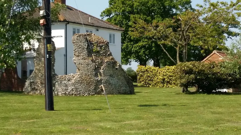
A country ramble to the lost parish of Buxlow
This walk provides a days ramble to view the ruins of Buxlow church. Many may have never heard of the parish of Buxlow, even those local to the area, and they can be forgiven for their ignorance since the parish was consolidated with Knodishall on 22nd February 1721.
Little is left of Buxlow church, which was dedicated to St Peter. There is merely a remnant of a wall from the old round tower that now rests in the garden of a domestic house which is viewable from the track that runs between the two houses. There are suggestions that the church was one of those recorded for Knodishall in the Domesday book and records certainly show there was a rector of the parish from 1301 onwards. By the middle of the 17th century it was reported to be 'decayed and ruinated tyme out of mind' although a rectors of the parish were still being recorded up to 1716 when Robert Witchingham held the honour.
Whilst admiring this piece of history the lady from the adjacent house engaged us in conversation stating that there have been many archaeological finds in the fields to front of the ruins. She even remarked of the many Roman coins that were constantly being unearthed. This is certainly not recorded on the Suffolk Heritage website so this is merely word of mouth. This does spark the imagination as the nearby hamlet of East Green is one of the suggestions of the long lost Roman station of Sitomagus. Maybe there was a connection from East Green to Aldringham which local folklore states was was a Roman port, the river Hundred in those days said to be navigable to sea going ships.
Note that a similar walk is described on this site with an alterntive route. This can be found on the page titled A Walk Around the Churches of Knodishall and Friston.

Walk Statistics
- Start location: Leiston
- Distance: miles ( km)
- Total Gain: ft ( metre)
- Total Descent: ft ( metre)
- Min Height: ft ( metre)
- Max Height: ft ( metre)
- Est. Walk Time:
- Walk type: Circular
- Walk Grade: easy
- Terrain: Footpaths and tracks
- Obstacles: There section that runs from the footpath down the lane from Knodishall church and diagonal crosses the field to a small footbridge across the Hundred River (no more than a simple brook) contained several obstacles to negotiate. The field has been sectionalised into small horse paddocks, divided up using electric fences with no proper access for footpath users. To navigate across this one is required to crawl under the flexible fence wires and also climb across a gate that was secured shut with knotte rope. The local council has been informed of this obstruction.

Maps
The following maps and services can assist in navigating this route. There are links to printed maps and links to downloadable GPX route data for importing into navigational software and apps.
- Ordnance Survey Explorer Map
- OS Explorer 212 - Woodbridge & Saxmundham
- GPX Route File
Route Validation Cards
Validation Date - 2018-05-20
- Time of Walk: 11:00 to 15:30
- Validators: Griffmonster, Kat
- Weather Conditions: Warm sunny day
- Notes: Initial route undertaken
Summary of Document Changes
Last Updated: 2026-04-20
- 2021-03-17 : Update website improvements and removal of ViewRanger reliance
- 2021-12-01 : Removal of ViewRanger links due to its imminent demise
- 2026-01-12 : Major website update with all walks recast to the new format


0 comments:
Post a Comment