Sussex Coast Path - Hastings to Eastbourne
Saturday, 14 March 2020
|
No comments
|
![]()
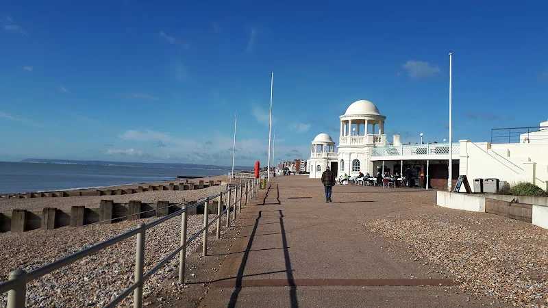
Coast route following the proposed route for the England Coast Path
A very typical English seaside walk passing through the resorts of Hastings, St Leonards and Bexhill to end at Eastbourne. There is plenty of promenade walking with some beach walking. The beach is predominantly shingle throughout which makes it hard going. Because of this the section around Normans Bay and Pevensey Bay uses the coast road behind the coastal embankment to make it easier going. The ends of the walk are linked by the railway making for a very pleasant one day sectional walk.

Walk Statistics
- Start location: Hastings Station
- End location: Eastbourne Station
- Distance: miles ( km)
- Total Gain: ft ( metre)
- Total Descent: ft ( metre)
- Min Height: ft ( metre)
- Max Height: ft ( metre)
- Est. Walk Time:
- Walk type: Linear
- Walk Grade: Moderate
- Terrain: Promenade, footpath, some pavement walking and some beach walking
- Obstacles: The beach is predominantly shingle throughout and it is tough work to walk across. There are a couple of instances where the beach is necessary although in most cases, especially around Normans Bay and Pevensey Bay, an alternative route via the coast road is used

Maps
The following maps and services can assist in navigating this route. There are links to printed maps and links to downloadable GPX route data for importing into navigational software and apps.
- Ordnance Survey Explorer Map
- OS Explorer 124 - Hastings & Bexhill
- Ordnance Survey Explorer Map
- OS Explorer OL25 - Eastbourne & Beachy Head
- GPX Route File
Accommodation
Willingdon Drove Travelodge, EastbourneRoomView in OS Map | View in Google Map
- Website
- https://www.travelodge.co.uk/hotels/459/Eastbourne-Willingdon-Drove-hotel
- Description
- Situated some three miles from Eastbourne seafront, this is nonetheless convenient for rail services with the Hampden Park Station 10 minutes walk away. There is also a Toby restaurant next door.
Transport
Various - Train Service
- Service Details
- Southern Rail - Southern railway services
- Timetable
- Southern Rail
Walk Notes
This is a good days walk that can be undertaken by anyone of average fitness. The route is flat throughout with most of the distance covered on promenade or hard surfaces. The ends of the walk are linked by the railway where frequent trains connect the two towns of Eastbourne and Hastings with late trains available
This is a true English seaside walk with all that glorifies the typical English south coast towns. Long Proms, piers and all the seaside paraphernalia with no apologies. There are plenty of options for refreshments and facilities along the route and always something new to see and admire.
The route is hard surface all the way through to Bexhill, a town that commemorates its place in history as the home of British motor racing. There is a commemorative stone at Gally Hill marking the starting line for the first international motor racing meeting that was held in 1902. On the seafront green is a sculpted vintage motor opposite the road to Bexhill Museum.
At the far western end of Bexhill the promenade runs out and there is a short trudge across the shingle before a path leads up to the road followed by a short walk along the pavements to emerge back onto the shingle. This is very tough walking and the proposed route of the England Coast Path leads off of this beach, beyond the beach huts, to use the coast road. This is a very welcome way ahead. Where the road turns inland the beach has to be used again through to Normans Bay. This is not too bad as the shingle at the head of the beach is pretty much compacted.
The route follows the road through the holiday park and uses the coast road through Pevensey Bay before returning to the beach via Bay Avenue. There are plenty of opportunities to walk short sections of the beach if one so wishes and, indeed on this occasion, we did just that to view the Martello Tower that sits proudly in front of the houses at the start of the village.
The route then picks up another hard surfaces path to lead through to Sovereign Harbour. This is an area of newly constructed flats that ends with an extensive inner and outer harbour. The link between these are a pair of lock gates that allow public access. A traffic signal operation has been installed to inform pedestrians as to which gate is accessible.
The final walk is along the promenade of Eastbourne to the pier. There is then a short walk up through the town to the railway station.
Directions
Coastal path and beach throughout
Follow the proms and hard path from Hastings through to Bexhill. Continue to the end of the prom and then drop down onto the beach. After a short distance there is a set of wooden steps to the top of the cliff providing access to Beaulieu Road. Turn left onto the road and rollow the road around to the junction with Cooden Drive. Turn left and follow the road as it twists around a doube bend and descends down a hill. At the bottom where the road makes a sharp turn right, return to the beach. Continue in front of the houses and beach huts and then return to the head of the beach to follow the road. The road drops down and turns sharp right to cross the railway. At this point proceed back to the beach. Continue to the first set of buildings where there is access back tot he road. Follow the road through the village and holiday park then turn left at the junction beyond.
Keep to the road until it reaches the village of Pevensey. Turn left into Bay Avenue and return to the head of the beach where there is a path in front of the dwellings. Where the art deco complex known as the Sandcastle juts out onto the beach, proceed around its permieter wall and then return back to the beach head following the defined track in the compacted shingle. Keep to this until it meets a paved track past the new buildings of the harbour complex. Where this meets the outer harbour, follow the pathway around the harbour and at the end are lock gates through to the inner harbour. Traffic lights indicate which lock gate can be accessed to proceed across to the other side. Follow the track around the harbour side back to the beach where the prom starts. Continue alogn the prom to the pier.
Take the first road inland past the pier, Terminus Road. Follow this through to the station.
Pubs
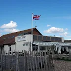
Aqua Bar, Pevensey Bay View in OS Map | View in Google Map
- Address
- Sea Road, Pevensey Bay
- Website
- https://www.facebook.com/AquaBarPevensey/
Popular beach side bar with access from the beach. Food available
What drew us into this beach bar was the sign on the eastern side of the building for Longman ales from a local Sussex brewery. Although only the best bitter was on offer it was nonetheless a worthy beer to be sampled. Staff were friendly and helpful.
Image Gallery


Route Validation Cards
Validation Date - 2020-03-06
- Time of Walk: 08:30 to 15:30
- Validators: Griffmonster, Kat
- Weather Conditions: Blue sky, sunshine and fairy warm for early spring
- Notes: Initial route undertaken
Summary of Document Changes
Last Updated: 2026-04-20
- 2020-03-12 : Initial Publication
- 2021-03-17 : Update website improvements and removal of ViewRanger reliance
- 2021-12-01 : Removal of ViewRanger links due to its imminent demise
- 2026-01-12 : Major website update with all walks recast to the new format


0 comments:
Post a Comment