Fen Rivers Way - Ely to Cambridge
Wednesday, 11 November 2026
|
No comments
|


An 18 mile hike along the Fen Rivers Way between Ely and Cambridge
From the Great Ouse river, the Fen Rivers Way then diverts down the river Cam, which transitions from a fenland drainage channel to a typical rural English river making a contrasting landscape.

Walk Statistics
- Start location: Ely
- End location: Cambridge
- Distance: miles ( km)
- Total Gain: ft ( metre)
- Total Descent: ft ( metre)
- Min Height: ft ( metre)
- Max Height: ft ( metre)
- Walk Time:
- Walk Grade: Moderate
- Terrain: Footpath, parks, urban areas

Maps:
The following maps and services can assist in navigating this route. There are links to printed maps and links to downloadable GPX route data for importing into navigational software and apps.
- Ordnance Survey Explorer Map
- OS Explorer 226 - Ely & Newmarket
- Ordnance Survey Explorer Map
- OS Explorer 209 - Cambridge
- GPX Route File
Walk Notes
The day started with broad blue skies and sunshine making the walk all the more delightful. The route leads from Ely riverside and soon out into the countryside. Close to the Southern Bypass, where the road straddles the river in a low profile bridge across the river, there are some strange metal sculptures

I can find no definitive information about these or what they represent. There are three items in total, a tall shaft with a circle, triangle, line and cross affixed to its upright, a wavy flat skateboard piece marked with a central squiggly line from which other lines diverge to the edge, and finally an oversized chair or throne will strange uprights at the top of its back. Are these supposed to represent eels I wonder. Performing searches and asking AI reveals very little other than connections to Sustrans cycle network and Knights Architects who designed the southern bypass bridge, but none of these connections are explicit.
The path is initially paved but soon gives way to a footpath that follows the Great Ouse river for 4 miles where the River Cam flows into it at the Fish and Duck Marina. From Ely, up this this point, the Fen Rivers Way is on the East side of the river and the Ouse Valley Way follows the West side of the river. The two long distance paths now diverge, the Fen Rivers Way following the River Cam through to Cambridge, while the Ouse Valley Way follows the Great Ouse River, through to St Ives and St Neots and beyond to its start at Syresham in Northamptonshire.
The route continues through to the hamlet of Upware where the unusually named pub, Five Miles from Anywhere: No Hurry Inn fronts the river. See the Pubs section and #Features section to find out all about its history. Even though it was only just 11 oclock in the morning, we nonetheless found the inn open and serving which was well worth taking time out for.
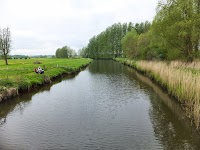
Another 5 miles and the hamlet of Clayhithe is presented. The Bridge Inn is tempting but although we succumbed to that temptation, they was no cask ale worth drinking and we elected to have soft drinks. Clayhithe is the point the the landscape transitions from wide open flat fenland where flood banks faithfully follow the generally straight coursed rivers, and turns to a more typical English river that winds its way through the countryside. This is quite a dramatic change and we both remarked that we were now walking on a riverside rather than a drainage channel. Historically Clayhithe and Waterbeach were the edge of the fens.
From this point onwards there were a lot more river craft, pleasure cruisers and closer to Cambridge, rowing boats. Cambridge also becomes a lot busier and urbanised. Bicycles become more numerous.
The completion of the trail needed a celebratory drink yet virtually all the pubs were Greene King owned houses which was not our preferred tipple. Friends in the past told how the best pub in the city was the Cambridge Blue, and hence we attempted to find this. This is on Gwydir Street off of Mill Road in the Petersfield area of the city. We have to resort to a bit of google mapping to take us there from the city centre. It is also under a mile from the station, where trains take you back to Ely.
Directions
The walk is pretty much self explanatory as it follow the Great Ouse River, then the River Cam.
- Leave Ely station onto Bridge Road, turn right, go under the railway bridge then over the river bridge. The Fen Rivers Way is on the right opposite the junction with Queen Adelaide Way. Turn right onto the paved path and follow the east side of the river.
- After 4 miles the River Cam merges with the Great Ouse River with the Fish and Duck Marina between the confluence. Keep to the east side and follow the River Cam.
- After a further 3 miles, the path enters the hamlet of Upware . Follow the waymarkers, with the Marina on the right followed by the Five Miles from Anywhere pub.
- Past the pub, there is a footpath that leads round to a road, Upware Road. Turn Left onto this.
- The road leads past the Upware Lock then the pumping station. After a further 250 yards on the right, a footpath leads towards the river, take this.
- After a further 4.5 miles, the path meets Clayhithe. Pass through the riverside hamlet, then turn right on the road and over the river bridge to where the Bridge Inn is located. The Fen Rivers Way continues on the left just across the bridge, following the west side of the river.
- The river will pass under the bridge of the A14, and further along the railway bridge. After 4 miles the urban area of Cambridge is well and truly seen all around. The path will come away from the river onto Water Street, then pass in front of the houses. Keep left to follow Water Street in front of the houses. Before the road turns sharp right, there is a path on the left opposite the Green Dragon pub. The path leads onto the Green Dragon bridge across the river and onto Stourbridge Common.
- Keep close to the river until Midsummer Common. Diverge away from the river, crossing the common down to Four Lamps roundabout.
- Go straight across the roundabout onto Short Street which then leads onto Emmanuel Road. At the junction turn left into Parker Street, proceeding along here until there is a park (Parkers Piece) on the right. Take the entrance into the park and cross this diagonally.
- Proceed out of the park onto Gonville Place bearing right as if carrying on the a similar direction. At the junction bear round to the left onto Hills Road. After 500 yards Station Road is on the left, take this and the station is at the end.
Pubs
Five Miles from Anywhere: No Hurry, Upware

- Address
- Upware
- Website
- https://www.fivemilesinn.com/
Originally a 1760s thatched alehouse called the Black Swan, that subsequently changed its name to the Lord Nelson in 1806. It then changed its name again to the Five Miles from Anywhere: No Hurry in the 1860s by Richard Ramsey Fielder, who self proclaimed as being the King of Upware.
The original thatched inn burned down in the 1950s, but a modern iteration of the Five Miles from Anywhere: No Hurry Inn opened on the site in 1995. It now offers a large riverside conservatory, garden and moorings. An ever changing guest ale is offered on the bar and meals and snacks in a reasonably priced menu.
More history about Upware and the pub can be found in the Features section on this page.
Review:This was one of those pubs where we almost did no go in. It was 11am, and, upon passing we noticed that the door was open, and there at the bar was the pump clip for a Wild Eye PA by Wildcraft Brewery. How could we refuse. Some way from its Norfolk home this, this is a mighty fine drop of ale.
The Bridge Inn, Clayhithe

- Address
- Clayhithe Road, Waterbeach
- Website
- https://www.chefandbrewer.com/pubs/cambridgeshire/bridge
The history of The Bridge pub at Clayhithe is inextricably tied to its role as a vital river crossing and ancient toll point on the River Cam. Long before the current brick structure was established as a 19th-century coaching inn, a ferry had operated on this exact site since the Middle Ages, managed under the strict authority of the Conservators of the River Cam. When the ferry was finally replaced by a toll bridge in 1871, the pub served as the official collecting hub, where boatmen, commercial bargees, and farmers moving livestock across the fens would pause to pay their duties.
For generations of river workers transporting coal and timber, it was a raucous, essential rest stop. In the late Victorian era, the pub’s character shifted dramatically when Cambridge University rowing crews adopted Clayhithe as the ultimate long-distance training destination from the city centre, cementing the inn’s reputation as a scenic riverfront haven for weary athletes and travellers alike.
Today it is part of the Chef & Brewer chain, part of the Greene King group offering standard fayre and Greene King ale.
Review:Unfortunately on this occasion there was no simple snacks, something like a sandwich, and we ended up having chips. The only ale on offer was the Greene King IPA which I find rather bland, therefore had to go for a soft drink
Cambridge Blue, Cambridge

- Address
- Gwydir Street, Cambridge
- Website
- https://cambridge.pub/the-blue/
Tucked away in the historic backstreets of the Petersfield area, The Cambridge Blue on Gwydir Street is a legendary drinking hole. Originally built in the early 1870s to serve the rapidly expanding railway community, the mid-terrace Victorian tavern spent its first century operating under the name the Dew Drop Inn. The pub took on its current, famous moniker in the mid-1980s when a former Cambridge University rower took over the lease, renaming the premises to honour the university’s iconic sporting colours and decorating the interior with distinct rowing memorabilia. This academic history is physically anchored inside the main bar, where a genuine, full-sized Cambridge Eight rowing boat signed by the crew hangs suspended directly from the ceiling.
The tavern made unique religious history in 1996 when it became the home of Britain’s first-ever official pub chaplain, a lay reader inducted directly by the Bishop of Huntingdon to offer prayers and a listening ear for the regulars over half-pints. Today, the pub has evolved into a celebrated independent haven for real ale and craft beer enthusiasts, frequently highlighted by the Campaign for Real Ale (CAMRA) for serving up to 14 live cask ales and a vast library of authentic Belgian Trappist bottles at any given time. Walking through the extension leads to a massive, sprawling beer garden. It offers a beautifully atmospheric setting that directly backs onto the stone monuments of Mill Road Cemetery, making it the ultimate destination to toast the conclusion of a fenland walk.
Review:What a revelation this pub is. It took a bit of time to find but that effort was very well worth it. On this occasion the Big Bang Theory by Nene Valley Brewery was a hazy, fully hopped, strong pale ale, just the job for the end of the walk. This was followed by Wingding from Only With Love brewery which was bursting withtropical fruit flavours. Very highly recommended classic old style pub
Features
Intro description
Ely and the Eel

The historic relationship between Ely and the European eel is one of the most fascinating economic stories of medieval England. Before the Fens were drained, the marshy waters surrounding the “Island of Eels” (Elig) were a thriving breeding ground, turning the creatures into the primary currency of the region. Coinage was scarce, so a formalized bartering system emerged where local manors paid their annual rents to the Abbot of Ely in “sticks” of 25 eels, yielding upwards of 75,000 fish a year. Remarkably, when the great Ely Cathedral was constructed in the 11th and 12th centuries, historical records show that the master stonemasons and laborers were frequently paid for their grueling work in thousands of preserved, salted eels.
Visitors to Ely are greeted by this history on the Great Ouse waterfront, where the striking Ely Eel Sculpture stands near the Maltings. Created by metalwork artist Peter Baker, this elegant bronze and steel monument depicts an eel twisting gracefully upwards out of the water, capturing the fluid movement of the creature that shaped the city’s destiny.
The sculpture serves as the official trailhead marker for Ely’s circular heritage trail and mirrors the distinctive blue eel logo found on the Fen Rivers Way waymarkers.
Upware Fort

In 2019, archaeological surveys uncovered the rectangular cropmarks of a moated Civil War gun battery, hidden just beneath the surface of a private field in Upware. Tucked immediately north of Old School Lane and just east of the Fen Rivers Way footpath near Upware Marina, this forgotten stronghold is briefly detailed in an Oxford Archaeology East report. Historians believe this site is the fort documented in local lore and early Ordnance Survey maps. Though the 75-foot-square earthwork remained visible into the 1930s, intensive farming in the 1960s largely ploughed it flat.
In its 1640s heyday, the fortification was a cleverly engineered military outpost. A formidable 40-foot-wide defensive moat, now completely dry, encircled the structure. The earth excavated from this ditch was piled inward to create an elevated interior platform, where modern investigators have discovered fragments of historical brickwork. This strategic stronghold did not stand in isolation; a now-dry channel directly linked the fort to a nearby river wharf.
The Upware Republic & The Uncrowned King

Sitting on the east bank of the River Cam, this tiny, isolated hamlet dates back to at least the 10th century, its name deriving from an ancient river fishing weir.
The focal point of Upware’s history is its legendary riverside pub, originally a 1760s alehouse called the Black Swan, that subsequently changed its name to the Lord Nelson in 1806.
By the mid-19th century, it gained the unforgettable name The Five Miles from Anywhere: No Hurry Inn. Between 1851 and 1856, this remote pub became the official headquarters of the “Upware Republic,” a high-spirited, convivial society of up to 300 Cambridge University undergraduates (including the famous novelist Samuel Butler) who fled the strict discipline of academic life to boat, fish, drink, and skate on the frozen fens. The eccentricity peaked in the 1860s when a rumbustious Cambridge Master of Arts named Richard Ramsey Fielder moved into the inn. Wearing a bright red waistcoat and corduroy breeches, he proclaimed himself “The King of Upware”. He ruled the tavern for years, famously challenging local bargees and river workers to bare-knuckle single combat to defend his self-appointed sovereignty. In 1862, he supposedly instigated the “Upware Bustle,” a local mining festival that degenerated into an all-out riot when the “King” and his miners successfully beat back the parish police.
The original thatched inn burned down in the 1950s, but a modern iteration of the Five Miles from Anywhere No Hurry Inn opened on the site in 1995, offering locals and visitors the exact same riverfront respite enjoyed by the Victorian “Republicans” and moth hunters centuries ago.
Beyond its rowdy pubs, Upware holds an important place in scientific history. In the 19th century, it was the primary staging ground for Victorian entomologists and “moth collectors” heading into the adjacent Wicken Fen (which became Britain’s very first nature reserve in 1899). So many academics and collectors would stay at the Upware inn and light oil lamps along the riverbanks to trap rare lepidoptera that locals complained the remote fens looked like a brightly lit city street at night.
Upware The Pumping Station

As the Fen Rivers Way leaves upware towards Cambridge, it passes the Upware The Pumping Station. This is at the point where the Reach, Burwell, and Wicken Lodes all collide with the River Cam. This station embodies the two-century-old battle to keep the surrounding South Level Fens from returning to a prehistoric swamp and highlights a fascinating geographic phenomenon known as the Fenland Paradox. When Cornelius Vermuyden and subsequent engineers drained the waterlogged fens, the exposed, oxygen-rich peat topsoil began to dry out, shrink, and blow away in the wind (a process called wastage).
Consequently, the height of the farmland sank drastically, leaving the surrounding fields considerably below mean sea level and far below the river level of the Cam. Because gravity now works against the landscape, the agricultural terrain is entirely artificial; if the Upware Pumping Station stops running, the natural water table would rapidly rise, and the entire valley would submerge under an inland sea within days.
Before mechanisation, the fens relied on unpredictable windmills. In 1821, the Swaffham Internal Drainage Board erected the first coal-fired, tall-chimneyed steam pumping engine at Upware. Known as the Swaffham Engine, it drove a massive scoop wheel to drag water out of the low-lying Swaffham Engine Drain and lift it up into the higher River Cam. A larger steam engine house replaced it in 1850 but was ultimately demolished in 1939 as fossil-fuel tech advanced.
Pumping shifted to a diesel-driven system in 1929. A major milestone occurred in July 1957 when a fully automatic electric pump was unveiled on the site, the first of its kind in the South Level. Lord Fairhaven famously inaugurated the automated era by pressing a single button to activate a system that could instantly shift 125 tons of water per minute from Burwell Lode into the Cam. The entire station was modernised again in 1987 to handle complex modern water management.
Clayhithe

Clayhithe is a small Cambridgeshire hamlet, close to the village of Waterbeach, and uniquely situated on the Fen Edge, the historical geographic transition zone where the low-lying, marshy wetlands of the Great Fens met the higher, drier agricultural claylands. Before the massive drainage projects of the 17th to 19th centuries, this environmental boundary separated a wilderness of seasonal peat bogs and floods to the north from permanent, arable farmland to the south. Because it was the furthest point downstream where the riverbank remained solid, firm ground, Clayhithe became a strategic inland port (“hithe”). Local communities capitalized on this dual landscape, farming crops on the higher soils while harvesting fish, wildfowl, and peat from the adjacent wetlands.
This specialized geography fueled an industrial boom dating back to the Roman occupation. In the 2nd century A.D., Romans exploited the local gault clay to build massive pottery kilns, a trade that evolved into a major brickmaking industry by the 1800s. Clayhithe’s distinct white facing bricks were transported downriver to construct many of Cambridge’s university buildings. Following the River Cam Navigation Act of 1702, the hamlet also became the primary toll-collecting hub for the entire river. It was operated by the Conservators of the River Cam, who built a grand, Grade II-listed headquarters there in 1842 using the local gault brick.
As an essential crossing point over the Cam, the location was served by a medieval ferry from the 1330s until 1872, when it was replaced by a private iron toll bridge. The county council eventually purchased and rebuilt the structure just before World War II, lifting the tolls. Today, the hamlet remains a peaceful riverside node. The Conservators’ House still functions as a working base for river maintenance, and the local bridge pub serves as a popular stop for walkers tracing the Fen Edge Trail.
Images


Route Validation Cards
Validation Date - 2023-03-27
- Time of Walk: 08:30:00 to 18:00:00
- Validators: Griff, Kat
- Weather Conditions: Started out bright blue skies and sunshine. As the day went on increasing clouds appeared and generally more overcast by the end
- Notes: Initial route undertaken
Summary of Document Changes
Last Updated: 2026-11-11
- 2026-11-07 : Initial publication







0 comments:
Post a Comment