Hengistbury to Sandbanks
Monday, 2 November 2026
|
No comments
|


A 9.5 mile beach walk along the Bournemouth Coast Path
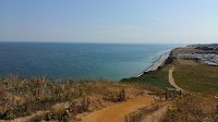
Lovely beach and promenade walk along the seafront from Hengistbury Head past Southbourne, Boscombe, Bournemouth and onto Sandbanks. This can be an added bonus for anyone wanting to continue walking the coast beyond the official end of the South West Coast Path

Walk Statistics
- Start location: Hengistbury Head
- End location: Sandbanks
- Distance: miles ( km)
- Total Gain: ft ( metre)
- Total Descent: ft ( metre)
- Min Height: ft ( metre)
- Max Height: ft ( metre)
- Walk Time:
- Walk Grade: Easy
- Terrain: Footpath

Maps:
The following maps and services can assist in navigating this route. There are links to printed maps and links to downloadable GPX route data for importing into navigational software and apps.
- Ordnance Survey Explorer Map
- OS Explorer OL15 - Purbeck and South Dorset
- Ordnance Survey Explorer Map
- OS Explorer OL22 - New Forest
- GPX Route File
Walk Notes
For the walks around this area we based ourselves at the Redcliffe Farm Campsite at Wareham. To get to Hengistbury Head by public transport from Wareham involved taking the Morebus Breezer 40 bus service through to Poole bus station and then transferring to the Beach Breezer 70 service. This is a seasonal open-top summer service that operates from late May to mid-September. The service connects Poole, Bournemouth, and Boscombe Pier and terminates at Hengistbury Head. It does take a substantial time but this provides a good sightseeing tour of the Bournemouth area. The service terminates at the Hiker Cafe next to the Hengistbury Head car park and it is a short walk to the beach.
The walk simply follows the coast with some beach walking and strolling along the promenades. There are clifftop alternatives and really it is up to the walker on the day on which serves as the preferential route. You cannot get lost, the coast is always in sight.
The final mile follows the road across Sandbanks from where there is a bus service that crosses the ferry to terminate at Swanage. This is the Breezer 50 service and connects Bournemouth to Swanage.
Return to Wareham is the Breezer 40 service that connects Swanage and Poole via Wareham.
This walk was a continuation of the South West Coast Path, east of Sandbanks. It is marked as the Bournemouth Coast Path and the Poole Coast Path as marked on some maps. The King Charles III England Coast Path takes a similar route. Most of this opened in 2022 although the section from Southbourne to Hengistbury Head is yet to open to the public (as of April 2026).
Directions
Bus services link Bournemouth and Hengistbury Head. The rest is simply following the coast.
- From the bus stop near the Hiker Cafe, cross the dunes to the beach
- Turn right along the beach and keep walking making the option of either beach or promenade or clifftop to whatever is your preference
- At the Sandbanks Hotel, cut through from the beach to the road then cut through the Sandbanks Hotel car park on the left to emerge onto Banks Road, Turn left and follow the road
- where the road forks, take either side which will meet further along by the ferry.
Pubs
The Moon in the Square, Bournemouth

- Address
- 4–8 Exeter Road, Bournemouth, Dorset, BH2 5AQ
- Website
- https://www.jdwetherspoon.com/pubs/the-moon-in-the-square-bournemouth/
For refreshments we headed into Bournemouth at the pier. Whenever we are out and about in unfamiliar places, if we can find no tap-room or recommended ale house we generally head to a Wetherspoons as local ales can usually be found in such an establishment. This particular Spoons was the Moon in the Square, where there was Jurrasic Dark by the Dorset Brewing Company. This was a rich, dark wheat beer, 5.9% in strength, which was a bit strong for a walking beer but certainly well worth trying.
The pub stands on the site of Victoria Villa and Library – the home and business premises of TJ Hankinson, who was Bournemouth’s first mayor, elected in 1890. Around that time, the buildings were replaced by King’s drapery store which traded here for several decades. There are tributes on the walls to famous people who have a connection with the town. This includes comedian Tony Hancock who spent his childhood in Bournemouth, a place that provided much inspiration for his famous comedy routines. Another celebrity is Mary Shelly, the creator of Frankenstein who is buried in Bournemouth.
As is the case with most Wetherspoons establishments, there are also many information boards and historic images of the town - a feast for the eyes and plenty of information to take in.
Features
Bournemouth Funicular Railways Overview
There are three funicular railways linking the promenade to the top of the cliffs. In east to west order they are:
- Fisherman’s Walk Cliff Lift (Located furthest east in Southbourne)
- East Cliff Railway (Located in the center, just east of Bournemouth Pier) Unfortunately, due to a cliff slide, this is currently out of action. Work to monitor the site is ongoing
- West Cliff Railway (Located furthest west, near the Bournemouth International Centre)
Prices and can be found at Bournemouth, Christchurch and Poole Council website cliff-lifts page.
The Fisherman’s Walk Cliff Lift

The Fisherman’s Walk Cliff Lift (also known as the Fisherman’s Walk Cliff Railway) is the youngest, and shortest operational funicular railway along the Bournemouth coastline. Located in Southbourne, it provides a crucial and charming link connecting the clifftop café and children’s play area of the Southbourne Overcliff to the promenade beaches below.
History and Technical Marvel
Constructed by the Bournemouth Borough and the Express Lift Company for £6,925, the funicular officially opened on 8 June 1935 by borough engineer F. P. Dolamore. It holds a unique record as the world’s shortest public funicular railway, operating across a track length of just 128 feet (39 metres).
Unlike its older siblings, the railway operates at a gentler 45-degree angle (a maximum incline gradient of 67.11%). It features a track gauge of 5 feet 8 inches (1,727 mm). The line utilizes two balanced cars that can carry 12 passengers each. While the physical cabs were modernised and replaced in 2012, the railway’s vintage character remains intact. It has transported an estimated 4 million passengers since its inception.
Current Status and Safety Updates
The Fisherman’s Walk Lift operates a normal seasonal schedule running from Easter until the very end of October. It provides a much-needed accessible transit point for visitors avoiding the steep zigzag paths.
The East Cliff Railway

The East Cliff Railway, also known as the East Cliff Lift, is a historic, disused funicular railway located in the coastal resort town of Bournemouth, England. Built to effortlessly bridge the gap between the seaside promenade and the high clifftop town above, it stands as a prominent engineering artifact from the Edwardian era.
History and Development
The funicular was constructed for the Bournemouth Corporation by Waygood and Company Limited and officially opened on April 16, 1908, by Lady Meyrick. It holds the distinction of being the first and oldest of the three coastal cliff lifts built along the Bournemouth shoreline, predating the West Cliff Railway and the record-setting Fisherman’s Walk Cliff Lift. From its very inception, the East Cliff Railway was uniquely designed to be electrically operated rather than relying on water balance, an advanced choice for the time, utilizing a 25-horsepower winding motor situated at the upper station.
Over more than a century of service, the railway saw several structural and technological modifications. The original wooden passenger cars were phased out in the 1960s and replaced by sleek aluminum-bodied counterparts built to a universal standard, making them completely interchangeable among all three of Bournemouth’s cliff lifts. The infrastructure was further overhauled in 1987 when concrete sleepers were introduced to replace the aging timber ones, and again in the 1990s when state-of-the-art electronic controls were installed alongside reinforced concrete stepping terraces to ensure long-term stability against the fragile cliff face.
Technical Specifications and General Information
The East Cliff Railway is a double-track funicular with an incredibly steep maximum incline gradient of 68.9%. It features an unusual track gauge of 5 feet 6 inches (1,676 mm) and travels a brief total length of 170 feet (52 meters). Under normal operations, the line utilized two balanced cars capable of carrying 12 passengers each on longitudinal bench seating, cutting out the exhausting, steep hike up the beach’s zigzag pathways.
Tragedy struck the railway in the early morning hours of April 24, 2016, when a massive landslide occurred along the sandstone layers of the cliff face due to extreme water saturation. Tonnes of debris collapsed down the slope, ripping away adjacent public footpaths and severely damaging the lower station booth, public toilets, and an adjacent café. Because the disaster occurred at night, no injuries were reported, and the cars, which were parked midway up the track in balance for the night—sustained minimal damage and were later safely removed.
Owned and managed by the Bournemouth, Christchurch and Poole Council, the East Cliff Railway has remained closed indefinitely since the landslide while local authorities assess long-term cliff stability and structural safety.
The West Cliff Railway

The West Cliff Railway, commonly referred to as the West Cliff Lift, is another historic funicular railway in Bournemouth, England. Built virtually alongside the East Cliff Railway, it serves as a critical transport link connecting the award-winning Bournemouth seafront promenade with the clifftop town above.
History and Development
The West Cliff Lift was constructed by the Bournemouth Corporation and officially opened on 1st August, 1908, exactly four months after its twin to the east. Like the East Cliff line, it was designed from its inception to be electrically driven, featuring a 25-horsepower electric motor housed within the winding gear of the upper station booth. A driver at the top station controlled the movements of the cars with the coordination of an assistant stationed at the bottom.
Though the lines were built concurrently, the West Cliff Railway was historically chosen to pioneer several network-wide upgrades. In 1962, its original wooden carriages were retired in favour of sleek, interchangeable aluminium cars, and the power system was upgraded to a 28-horsepower three-phase model. The track layout was fully re-laid with concrete foundations in 1987, followed by the integration of modern electronic control systems in the 1990s.
Technical Specifications and Overview
While visually similar to Bournemouth’s other historic lifts, the West Cliff Railway possesses its own distinct layout properties:
- Track Length: It features a slightly shorter track length of 145 feet (44 metres) compared to East Cliff’s 170 feet.
- Track Gauge: It utilizes a wide track gauge of 5 feet 6 inches (1,676 mm).
- Maximum Incline: It operates at an incredibly steep maximum gradient of 70.4%.
- Car Capacity: Its original passenger cars were designed slightly larger than East Cliff’s, historically carrying 16 passengers per car instead of 12.
Location and Current Status
The upper station of the lift is situated on the West Cliff promenade, closely positioned near the landmark Bournemouth International Centre (BIC) and the Highcliff Marriott Hotel. Under normal conditions, it operates seasonally between April and October to ferry tourists from the beaches.
Images


Route Validation Cards
Validation Date - 2023-07-05
- Time of Walk: 11:00:00 to 16:30:00
- Validators: Griff, Kat
- Weather Conditions: Warm sunny day with patchy clouds
- Notes: Initial route undertaken
Summary of Document Changes
Last Updated: 2026-11-02
- 2026-11-02 : Initial publication






0 comments:
Post a Comment