A 10 mile circular walk through the Suffolk Coastal Area of Outstanding Natural Beauty taking in Sizewell and the Minsmere Bird Reserve
One does not have to have an enthusiasm for ornithology to enjoy this walk. The natural surroundings of marshland and heathland are enough to inspire everyone and there is a lot of associated history along this route which dates back to the 12th century when Leiston Abbey once occupied an island in the marshes. Note that charges apply to the Minsmere section.
A scenic riverside walk linking Beccles with the historic Geldeston Locks pub, this route offers meadow paths, peaceful stretches of the River Waveney, and glimpses of Norfolk’s rich folklore and heritage. Perfect for an afternoon outing, it combines gentle countryside walking with a memorable stop at one of the region’s most characterful pubs.
A 10 mile walk following the southern side of the parish boundary of Leiston in coastal Suffolk.
This is the second article devoted to the walk following the route of a 17th century perambulation around the southern side of the Leiston Parish boundary. This article concentrates on two landmarks from the past, namely Sizewell and Thorpe Beacons, which are thought to have been part of the Armada early warning system.
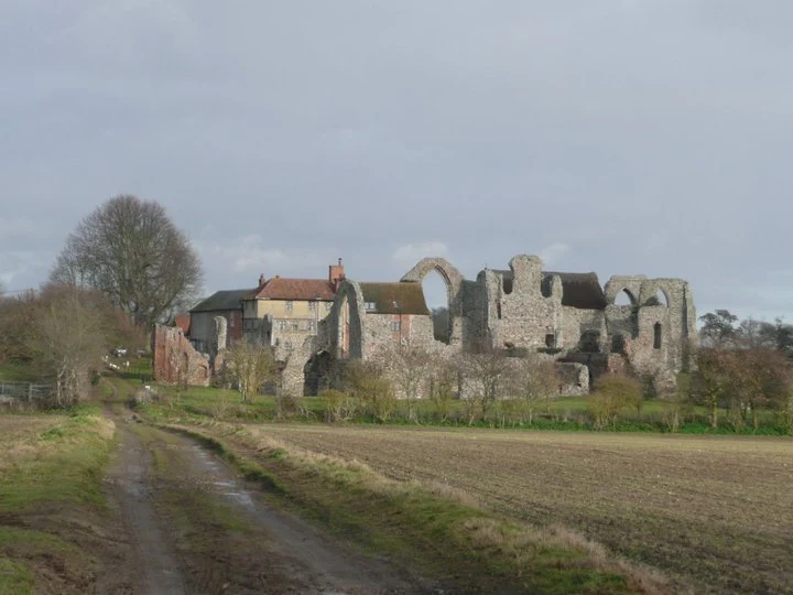
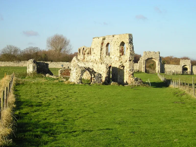
A 10 mile circular walk around Leiston and Eastbridge in Suffolk
Leiston Abbey was originally founded in the late 12th century by Ranulf de Glanville. The original building was constructed on an island in the Minsmere marshes. Two centuries later, due to the inhospitable conditions on the marsh and constant flooding the Abbey was moved inland, lock stock and stone to a site close to Leiston. Despite a great fire in 1367 and much demolition following the dissolution of the monasteries there still remains some impressive ruins. There is still a remnant of the old Abbey, with the former chapel building sitting in its island position above the marsh, decaying into the landscape and containing a WWII pill box. This walk visits both sites making a well worthwhile walk.
A 13 mile circular walk along the Sandlings Walk between Knodishall and Snape
With limited public transport this walk offers a circular route to incorporate the Sandlings path from Knodishall to Snape. Starting and ending at nearby Leiston it incorporates The Sailors Path and the Suffolk Coast Path to make a worthwhile day walk. The route passes Friston mill and Hall and the burial grounds where a Saxon burial ship was discovered. With pubs at Friston and Snape it provides for a great days ramble.
A 15 mile circular walk along the Sandlings footpath between Dunwich and Southwold, with an option of returning either via the beach or the Suffolk Coast Path through Dingle Marshes
This is the final stage of the Sandlings Walk from Ipswich to Southwold. Starting at Dunwich, it takes the trails through Dunwich Forest and heads over Walberswick Heath to Southwold. The woods are full of mushrooms and nuts and berries this time of year... and hops! This is a lovely walk through the woods and well worth the effort. To make the route circular, the return is either via Dingle Marshes, or the Suffolk Coast Path or if the tide is out then its an easy walk along the beach.
A circular walk through the quintessential Suffolk countryside following the River Alde
A circular walk following country lanes with a few footpaths along the Alde Valley. This is typical Suffolk countryside where one can take a lazy stroll. There are pubs to visit, three to be precise and all named the White Horse, along with three churches that are not named the White Horse!
Circular Walk between Saxmundham and the village of Rendham
Six mile circular walk across the Suffolk countryside with a worthy stop off at the White Horse pub at Rendham. Woodland, open fields, babbling brooks make this typical of this part of Suffolk. And there is history to, with the Roman bronze head being discovered in the river at Rendham back in 1907. How did it get there?
This walk uses the beach and the Sandlings Path to provide a days walk to Dunwich from Leiston via Sizewell. One should time this walk such that the beach is walked a couple of hours either side of low tide when there is a little sand to walk along. At other times the beach is predominantly shingle and the walker may find it easier to follow the Suffolk Coast Path which is waymarked from the north side of Minsmere where it continues up onto the cliffs.
An easy 8 mile Norfolk coastal walk along beach and clifftops between Sheringham and Cromer
The Norfolk Coast Path was rerouted in 2014 as part of its inclusion to the England Coast Path. It now navigate alogn the cliff tops for most of the distance along what used to be permissive paths that have now become public. This walk uses both coast path and beach to create a delightful walk along this awe-inspiring section of the North Norfolk coast. Do check tide times and make sure the beach walk is undertaken 2 hours either side of low tide.
A 13 mile circular walk from Leiston to the White Hart Beer Festival in Aldeburgh
Easter 2011 was a really warm and sunny occasion and what better way to spend a Good Friday and Easter Monday than a casual walk through to Aldeburgh where The White Hart pub was holding its 9th Annual Beer Festival. Over 30 ales from across the country plus a selection of real cider, this really had to have something for everyone.
A 7 mile walk between East Runton and Sheringham in Norfolk, searching out a couple of good pubs and following Beeston Beck across Beeston Common.
This picturesque trail follows the foot of Inkleborough Hill to West Runton then navigates down to the northern end of Beeston Back Common where it follows the stream known as Beeston Beck down into Sheringham, past the site of an old watermill, now replaced by terraces of housing. Return is via West Runton with a stop at the Village Inn. At only 7 miles, this is a simple and easy afternoons stroll.
An easy and captivating walk along Norfolks River Bure
Not only does this walk provide some classic Norfolk scenery and historic features but it also traces the route said to be taken by the phantom carriage of Sir Thomas Boleyn in his annual act of penance for betraying his daughter Anne when she was sentenced to be executed. The walk is then made into a circular route by returning via the Bure Valley Path alongside the narrow gauge Bure Valley railway.
A 7 mile circular walk connecting the Norfolk town of North Walsham with Bacton Woods
The Norfolk countryside holds a lot of hidden gems and this walk discovers a few. The route uses country lanes and footpaths to provide an easy circular ramble. The woods are worth the effort and hold a hidden secret of the location of a gibbet on which, during the late 18th century, William Suffolk's body was hanged in chains for his murderous deeds. The return route passes the iconic Ebridge Mill and then leads onto the Weavers Way for the final section back to North Walsham
A 12.5 mile walk between Aldringham and Aldeburgh through the Suffolk Coastal Area of Outstanding Natural Beauty
There is a variety of differing scenery along this route, gentle hills around Aldringham, boardwalks across the marshes at The Fens, a walk along the old Aldeburgh railway and an estuary walk along river defences of the Alde. With such treasures as the pretty little church at Aldringham, tucked away in the trees and away from civilisation and the magnificent church of St Peter and St Paul at Aldeburgh, there is plenty to see and explore.
Short circular walk through the Suffolk countryside around the village of Sweffling
The second circular walk that starts and ends at the Sweffling White Horse pub. This leads the rambler across river valley, woodland and some amazing Suffolk countryside. This is a perfect way to spend a Sunday morning, ending up with a pint and some lunch at the pub which really is a traditional old local with a tap room full of local ales.
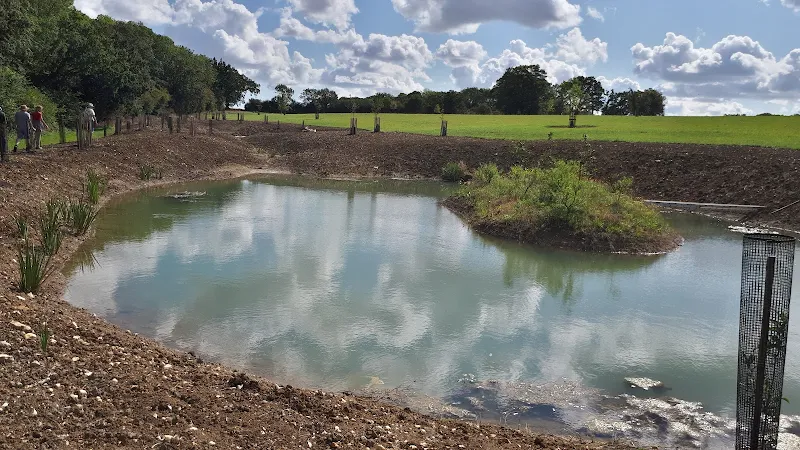
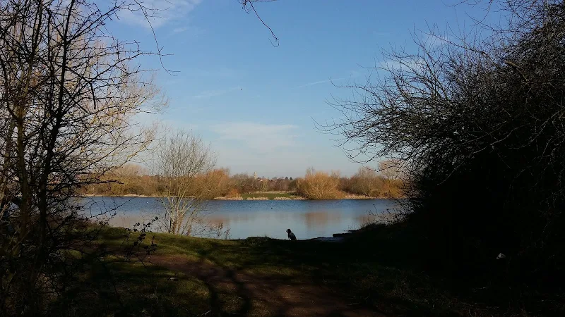
a 4.5 mile circular walk using well maintained footpaths through the Lakes nature reserve
An easy and pleasant ramble through the lakes area that occupies the Nene Valley in this part of Northamptonshire. Well maintained paths and tracks make this accessible for most folk and access into Higham enables one to break ones journey for refreshments with ample cafes and inns located in town.
On a Sunday morning, with the sun shining and a little warmth in the air one can witness the queues of traffic that wait to enter the hallowed avenues of the Rushden lakes shopping complex. The faithful patiently wait in turn to present their sacrifices to the Gods of consumerism in return for precious commodities.
It is a good feeling to leave this scene behind and get back to more natural surroundings. This walk starts at the roundabout just past the bus stop as one enters the shopping area. One needs to head behind the Decathlon store onto a path that initially appears to lead nowhere and looks to be nothing more than an access path to the rear of the store. Despite this, the path runs a short length alongside a wooden boarded fence then turns to access the lakes area. It is like a secret passage that any member of Enid Blytons Famous Five would discover on an adventure armed with the ubiquitous ginger beer and cucumber sandwiches.
Before the 1950s this area was all fields stretching out across the Nene Valley. Riverside meadows that were part of a flood plain which would regularly flood each winter. Things have changed drastically in the decades since, the whole valley from Northampton down to Ringstead is now pockmarked as a result of aggregate extraction, leaving numerous lakes of varying sizes. It is clear that mankind has had a huge impact on this area, changing the landscape irreparably. The result of this progress is a haven of nature with the diversity of wildlife and flora greatly expanded since the days of meadow and field, so I guess one can argue that progress is not all necessarily bad. Even the winter floods are now somewhat a thing of the past with the flow of water down the Nene valley better managed upstream.
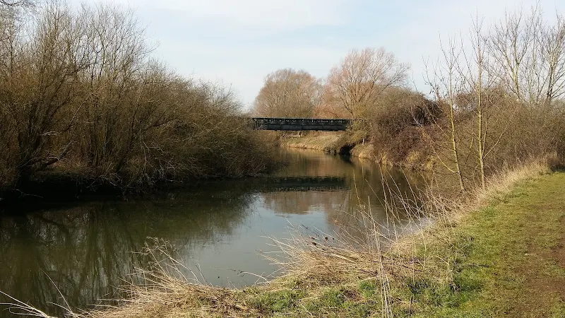
Bailey bridge across the River Nene
The well maintained path leads a straight course between Delta Pit lake on the left, and a series of lakes known as Wilson's Pits on the right. It is uncertain where the names are derived from but one assumes they are connected with the gravel extraction companies. Having said that, the area in Rushden on the Wellingborough Road adjacent to Adnitt Road was also known as Wilson's Pits, certainly from the 18th century onwards. This is honoured in the name of Wilson Road that runs along the western edge of the area. Whether there is any connection to the lakes area of the same name is unknown.
One soon comes to a bailey bridge across the main river. The humble River Nene. It flows from Badby to The Wash and is one of the principle water courses through Northamptonshire. One should note that the pronunciation of the river in these parts is Nen (rhyming with hen). This is Northamptonshire. It is called the Nen here. For countless generations it has and always will be the Nen. Even some old publications from the 19th century and earlier use the spelling of Nen. It is not until Peterborough that the name changes to the more upmarket sounding Nene (rhyming with been).
The bailey bridge was added as part of the rejuvenation of the area during the development of Rushden Lakes. There had previously been a bailey bridge here as part of the gravel extraction but that had long gone. The path then leads over another bridge that crosses a backwater that has now become the northern extremity to Higham Pits lakes, and onto the former Northampton and Peterborough railway trackbed. The line closed back in 1964 although the track was not lifted until the early 1970s and some freight used the line up until that point. I have memories of my dad proudly relating how he witnessed the Royal Train passing through the nearby Ditchford station although I cannot provide the exact time period for this event. Of course, Ditchford, for those who know the area, was famous for its treacle mines and some may say these very lakes are nothing to do with gravel extraction but are the result of centuries of treacle mining.
Former Northampton to Peterborough railway trackbed
These days it is difficult to determine that a railway once ran along these tracks such is the case that nature has firmly taken the trackbed over. Thick vegetation and trees cover either side of the well used path. There are occasional viewing areas where vistas across the lakes can be glimpsed with the town of Irthlingborough sitting across the way with its distinctive lantern towered church protruding above the rest of the buildings. The town is locally known as Artlenock, a name whose derivation is unknown. It has always been known as Artlenock around here and hopefully that tradition will continue.
Eventually the path comes to a cross roads of tracks where one needs to turn right and head into Higham, or Arm if one uses the local dialect. Once again, this is a well maintained pathway. Years ago it was nothing more than a footpath that connected Artlenock and Arm. This was a convenient route across the valley and I have many memories of using this path in days gone by when heading out to catch a band playing at the Bull in Irthlingborough then having to negotiate the way back in the dark. In winter it was not the best of paths and on many occasions one emerged back into Higham with shoes caked in mud and jeans equally splattered. These days it is a part of the Rushden Greenway, an urban path that links Rushden, Higham and Irthlingborough.
The track passes over the A45 trunk road by way of a large concrete footbridge bringing one into the extremities of Higham. There is then a steady 30m climb into the town passing through a sprawl of modern housing estates. Dont be fooled into thinking this path is a modern concoction designed to promote exercise for the urbanites who reside in these boxed dwellings. This is an old path, an old track that existed centuries before the mass expansion of these East Northamptonshire towns and villages.
The path leads out onto Saffron Road past the cemetery and the Recreation Ground which contains a pond known as Saffron Moat. The grassed area takes its name from the fields which were used to grow crocuses from which saffron could be farmed in medieval times. The moat also dates from this period and reputedly supplied the nearby Chichele college with fish.
We return down Wharf Road to the river. In fact this is not the river any more, its course diverted when the Higham bypass was constructed. All that is left is a lake with a spur that was once the original course of the river. Gone is the single arched brick humpback bridge that provided access across the river and set a scene for many idyllic picture postcard views. The bridge has been replaced by rather grotesque metal structure that allows walkers and anglers access to the lakes area. Functional rather than aesthetic.
Once upon a time the Wharf would have been a busy trading place used to load and unload goods that were transported along river. No doubt the local brickworks that stood adjacent to the bridge up until 1915 made ample use of the Wharf. Long gone also is the Anchor Inn that once stood here to the right as one faces the bridge. This public house supplied travellers and locals with Dulleys ales from the Wellingborough brewery which was established in 1802 and lasted until it was taken over by Praeds brewers in 1920.
The coming of the railways spelt the end for the trade from Higham Wharf and the inn closed its doors during WWI although it is said they still offered non-alcoholic refreshments in the 1920s, no doubt to the locals who used the wharf for recreational purposes, swimming in summer and ice skating on the flooded meadows in winter. By the 1950s the building was derelict and now the area is nothing more than the end of a modern housing estate where a footpath follows the lakeside through the maintained parkland area.
Another concrete footbridge spans the A45 and there is a riverside path that leads back to the bailey bridge which one encountered earlier. This is all part of the Nene Way, a long distance trail that follows the full course of the river. We leave the Nene Way at the bailey bridge to return back along the path that the walk started out along to complete a very worthwhile ramble.
A 12 mile circular walk starting at Eyke and incorporating the UFO Trail in Suffolk's Rendlesham Forest
The Rendlesham UFO trail is a waymarked 3 mile trail around the eastern end of Rendlesham Forest that navigates around the key areas that were involved in the Rendlesham Forest Incident of 1980 in which both civilian and military personnel witnessed unexplained craft land within the forest. Although this can be walked by parking up at the visitor car-park in the forest, a longer alternative is to take the footpaths from Eyke, and make a day of this most wonderful and intriguing part of Suffolk.
A simple 3 mile circular route in the Forest of Dean on the sides of the Cannop Valley
A walk around the Forest of Dean in Gloucestershire roughly following a trail around a series of sculptures. Trees, sculptures, views, more trees and if you are lucky wild boar, deer and sheep can be seen in this wonderful piece of woodland.
A 14 mile walk between Saxmundham and Darsham along the East Suffolk Line Walk.
It is Yoxford that gives us the name of this walk which is part of the East Suffolk Line Walks and this specific ramble extends the line walk to return to Leiston where a regular bus service connects the two ends. Yoxford sits on the banks of the River Yox surrounded by three country house parks; Sibton Park that contains large well stocked fishing lake; Grove Park situated in the village; and Rookery Park on the Leiston road. This has earned Yoxford the name of the 'Garden of Suffolk'. The whole route of this walk is a pleasant amble through the rural fields of Suffolk with a return journey through the pretty country lanes following the Minsmere river through to Middleton, Theberton and finally Leiston.