Norfolk/Suffolk Coast - Gorleston to Kessingland
Wednesday, 14 November 2018
|
3 comments
|
![]()
A 14 mile coastal walk between Gorleston and Kessingland crossing the border from Norfolk to Suffolk
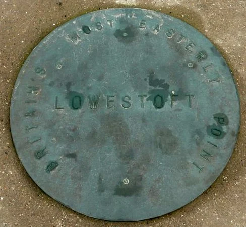
This mighty fine walk takes the avid rambler to the most easterly point of the British Isles, Ness Point that is located in front of Lowestoft. The point is marked with a large circular ground compass with distances and direction to well known landmarks around the globe. The route uses cliff top paths, proms and beaches and makes for a great days walking.

Walk Statistics
- Start location: Gorleston
- End location: Kessingland
- Distance: miles ( km)
- Total Gain: ft ( metre)
- Total Descent: ft ( metre)
- Min Height: ft ( metre)
- Max Height: ft ( metre)
- Est. Walk Time:
- Walk type: Linear
- Walk Grade: Easy
- Terrain:

Maps
The following maps and services can assist in navigating this route. There are links to printed maps and links to downloadable GPX route data for importing into navigational software and apps.
- Ordnance Survey Explorer Map
- OS Explorer 231 - Southwold & Bungay
- Ordnance Survey Explorer Map
- OS Explorer OL40 - The Broads
- GPX Route File
Transport
First Group - Bus Service
- Service Details
- There is no longer a through service between Kessingland and Gorleston. It is recommended to use the Traveline website to determine the best service for ones journey.
- Timetable
- https://www.traveline.info/
Walk Notes
Kessingland may appear to be a strange destination for this walk when the two main towns along the route are Gorleston and Lowestoft. Yet there is reason for this madness. There is a free car park at Kessingland and there is a bus service from the village into Lowestoft from where there are frequent connections through to Gorleston. There used to be a service all the way through to Gorleston but unfortunately that is no longer the case. Lowestoft parking is expensive as is Gorleston, therefore this provides a worthwhile alternative.
This is an enjoyable walk that crosses the Norfolk/Suffolk border using the cliff top paths and promenades with some beach walking. The England Coast Path navigates along the first section from Gorleston to Hopton which follows the prom and then leads down onto the beach. This should be navigable in all but excessively high tides or storm surges. There is no alternative as the cliff top is marked as private. If one can get along the beach behind the wooden defences and it is past high tide then the route should be accessible. Once at Hopton there is an alternative coast path route through the holiday village as the beach here is not always accessible.
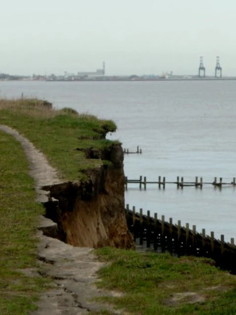
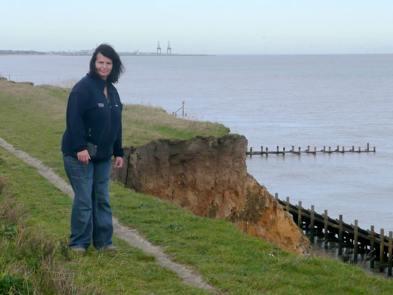
Beyond Hopton one can continue along the cliff top. In fact this is the advisable route due to the erosion along this section of coastline. One should take care as there are regular cliff falls along this section. The path has already been diverted around the inland side of the former cold war radar station that sits on top of these cliffs. If access is blocked by a fall then one needs to navigate up to the coast road to get into Corton. It is thought that by 2020 the Suffolk section of England Coast Path will in instated and a permanent path that recedes with the erosion will be introduced.
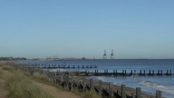
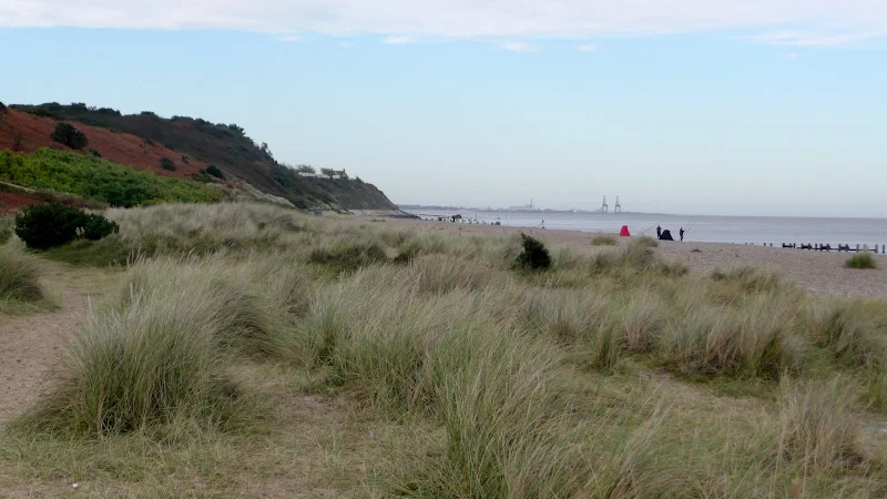
Unfortunately the road has to be used through Corton before the next coastal access is found, this being Tramps Lane at Gunton which leads across the heathland and down to the prom at North Beach in front of the Denes. Then follows an easy walk all the way through to Ness Point. Now, I have visited Ness Point numerous times and the one thing that I have noticed is the lack of people. In fact I can categorically state that I have never met a single person at Ness Point. Maybe it is because it is hidden away behind an industrial area. Maybe it is just not as renowned as other landmarks such as Lands End, where tourists flock, so much so that a garish theme park has been constructed there. All of this is not a criticism but an observation for I personally like the solitude. However, this seclusion may not last, as the media reported in 2017 that £1m had been secured to develop the landmark into a prime tourist attraction. Sadly, for me this would be a place to then avoid. I like it much more as one of those secret Suffolk locations where, when one visits, one is alone with nothing but the wild sea and the empowering sky.
The final trek through to Kessingland takes one along the prom to the South Beach at Lowestoft and then through to Pakefield. The remaining distance can be achieved along the beach provided the tide allows. It would need an excessive high tide or storm surge to prevent access along this section.
Directions
The beach can be walked as far as Hopton. From here there is a clifftop path into Corton followed by a road walk until a path at Gunton allows access back to the beach.
Follow the River through Gorleston down to the seafront. From here keep to the beach through to Hopton. The concrete sea defences just beyond Hopton are cordoned off due to storm damage but a cliff top path leads through to Corton. After the woods just south of Corton there is a path back down to the beach. Continue along this through to Ness Point where you need to follow the roads in order to cross the river at the bascule bridge. Head south out of Lowestoft along the prom. This leads up and across the cliffs to just south of Pakefield where you can either follow the waymarkers for the Suffolk Coastal Walk or take the path down to the beach. Note that the Suffolk Coastal Path is a walk along the main A12 to Kessingland so the beach route is a lot more pleasant experience. No contest really!
Pubs
The White Horse, Corton View in OS Map | View in Google Map

- Address
- 47 The Street, Corton
- Website
- https://www.facebook.com/The-White-Horse-Corton-1626809207576397/
The White Horse is the oldest extant hostelry in Corton, going back almost three hundred years, although its present site is not the original one. The first White Horse stood in the old main street, north of Baker's Score, next to Bleak House but was abandoned sometime between 1844 and 1862 when a new inn built on the present site. In 2009 the pub underwent an extensive refurbishment and now the business focuses on the restaurant trade. Freshly prepared food made from locally sourced supplies accompanies ales by Green King with other guest ales.
At first we hesitated as to whether to frequent this establishment on account of the Green King motifs across the pub. Eventually we decided to venture in and was rewarded with an excellent and refreshing pint of Wolfs Coyote.
Features
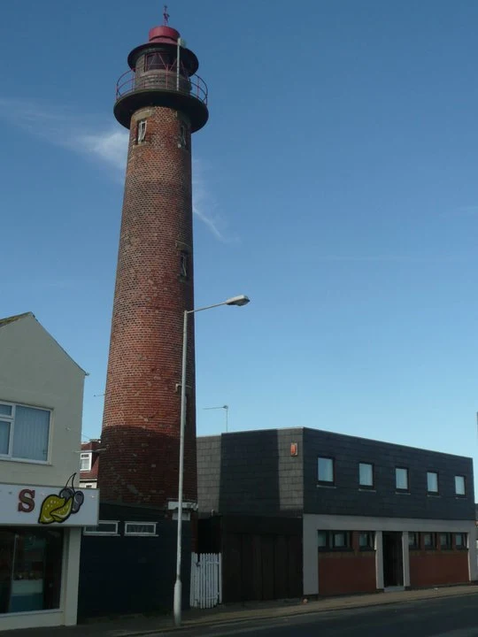
Gorleston LighthouseView in OS Map | View in Google Map
Gorleston Lighthouse, a round red brick tower, stands between the amusement arcade and other buildings on Quay Road. It seems an odd place to locate a lighthouse but such a location does make it stick out from the rest of the buildings. It was built in 1878 and carries two lights. A rear white light for the harbor entrance range (4 seconds on, 2 seconds off) and a fixed red light displayed from the gallery.
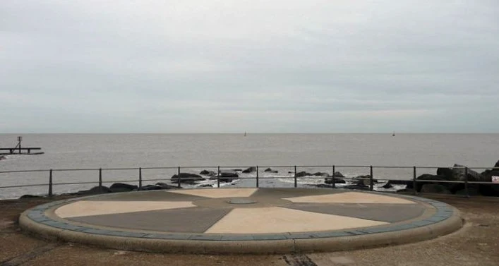
Ness PointView in OS Map | View in Google Map
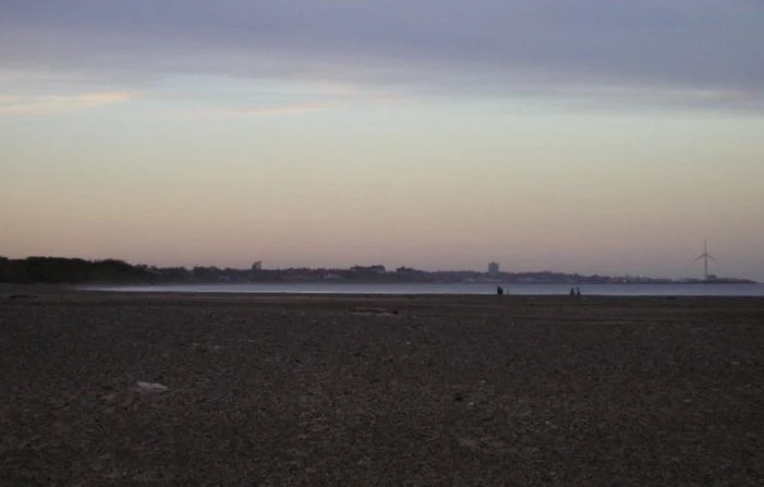
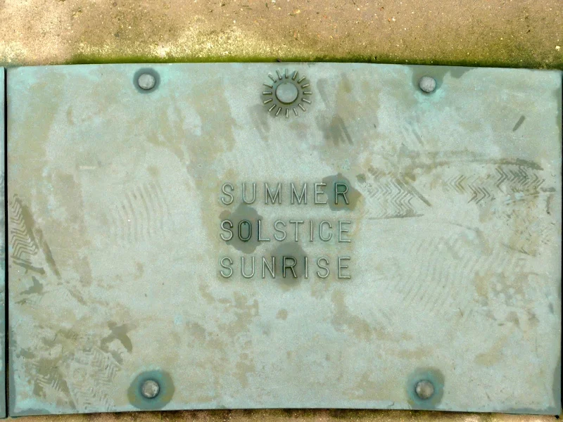
Ness Point is Great Britain's most easterly point. It is marked with a direction marker known as Euroscope which indicates places and countries and their distances. It also marks the summer and winter solstice direction. Also located at Ness Point is Britain's tallest wind turbine, which is nicknamed "Gulliver". It stands 180 meters tall, generating energy for the National Grid.
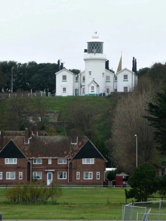
Lowestoft LighthouseView in OS Map | View in Google Map
Lowestoft lighthouse was built in 1609 as a response to petitions from shipowners and merchants who had lost cargoes and vessels on the dangerous sandbanks and shoals around the East coast. It was one of a pair of lighthouses built to aid vessels through the Stamford Channel, an inshore passage used by small vessels which no longer exists. Its sister lighthouse was finally extinguished in 1923. Originally the lighthouse was erected on the low lying foreshore but was relocated on the cliffs in 1676 to aid ships that were far out at sea. The light was originally made from tallow candles and was finally electrified in 1870 which was then automated in 1975.
Links and Bibliography:
Image Gallery


Route Validation Cards
Validation Date - 2010-11-13
- Time of Walk: 10:30 to 16:00
- Validators: Griffmonster Kat
- Weather Conditions: The walk was separated by a weather-front that sat across the Norfolk Suffolk border resulting in the strange anaomoly where Norfolk was bathed in sunshine and blue skies and Suffolk was cast in a dreary grey and heavy clouds.
- Notes: Initial route undertaken
Summary of Document Changes
Last Updated: 2026-04-20
- 2010-11-14 : Initial publication
- 2012-12-28 : Add in information about recent coastal erosion
- 2015-01-11 : Add link to animated video of the walk
- 2017-02-05 : General website updates
- 2019-01-13 : General website updates + rewrite notes
- 2021-03-17 : Update website improvements and removal of ViewRanger reliance
- 2021-12-01 : Removal of ViewRanger links due to its imminent demise
- 2026-01-12 : Major website update with all walks recast to the new format


3 comments:
Living in Norfolk I am always going to say it is the best part of the east. Found your blog and keep it coming.
Martin - I have to admit that I walk the North Norfolk Coast Path each year because it is such a pleasure to keep going back there
There is a pot of £161 million called Slow ways active travel England, for new footways and cycle paths the Government did a survey of disused railways for conversion and the Hopton/Gunton section didn't even register! https://assets.publishing.service.gov.uk/government/uploads/system/uploads/attachment_data/file/1060435/initial-assessment-of-historical-railways-estate-forward-programme.pdf
If people make requests to Norfolk council to apply for this fund for the Longfulans lane, Hopton to Stirrips Lane, Gunton to be made into a footpath then we can all have safe passage!
Post a Comment