Norfolk Coast Path - Burnham Overy Staithe to Brancaster
Wednesday, 18 December 2019
|
No comments
|
![]()

A 6 mile walk following the North Norfolk Coast Path between Burnham Overy Staithe to Brancaster
Wide open areas of marshland provide an enticing setting for this easy walk. Sailing boats, marsh, a tidal pool and the site of a Roman fort provide plenty of interest, together with three pubs, what more could one ask for of an afternoons stroll.

Walk Statistics
- Start location: Burnham Overy Staithe
- End location: Brancaster
- Distance: miles ( km)
- Total Gain: ft ( metre)
- Total Descent: ft ( metre)
- Min Height: ft ( metre)
- Max Height: ft ( metre)
- Est. Walk Time:
- Walk type: Linear
- Walk Grade: Easy
- Terrain:

Maps
The following maps and services can assist in navigating this route. There are links to printed maps and links to downloadable GPX route data for importing into navigational software and apps.
- Ordnance Survey Explorer Map
- OS Explorer 251 - Norfolk Coast Central
- GPX Route File
Accommodation
Woodhill Park CampsiteView in OS Map | View in Google Map
- Website
- https://www.woodhill-park.com/
- Description
- Located on the clifftops at East Runton, half way between Sheringham and Cromer, this highly recommended touring site is ideal for exploring North Norfolk with public transport available to many destinations from the entrance to the site.
Transport
Various Operators - Bus Service
- Service Details
- Coasthopper CH1, CH2, CH3 - The Coasthopper services link Hunstantion, Wells-next-the-Sea, Sheringham, Cromer, Mundesley and North Walsham including all intermediate villages. See the Traveline website to determine the current timetables and services.
- Timetable
- www.traveline.info
Walk Notes
The beauty of the North Norfolk section of the Norfolk Cost path is its accessibility with public transport. The Coasthopper bus service operates throughout the distance from Hunstanton to Cromer and they will stop, when it is safe to do so, at any point along the route regardless of whether it is an official bus stop. NOTE: the coasthopper service has changed since this was written. The small and nippy busses have all gone to be replaced by standard single deck vehicles operated by the Lynx and Sanders companies. It is unclear whether these buses can be hailed down at anything other than an official bus stop. Even so, with numerous stops, one can tailor a walk to ones needs, dependant on age, ability or time constraints, in full knowledge that the end points are linked by this convenient bus service. This section typifies this, starting with a three mile stroll from Burnham Overy Staithe to Burnham Deepdale and access to the coast road at each end. From Burn Deepdale all the way through to Brancaster there are various access points to the coast road and its pubs. So whether one is out for a pub crawl, or to admire the marshes, or to bird spot or just to have a peaceful afternoons ramble then this is all conveniently catered for. Of course one could continue along to Thornham, or Holm or even Hunstanton if that is ones wish. It really is that easy. However, this specific instance describes the short 6 miles from Burnham Overy Staithe to Brancaster. There are other pages on this site that describe the other sections.
The first notable feature on the walk is the Burnham windmill, standing impressively on the hill before the footpath heads out around the marshland that makes up Norton and Deepdale marshes. Little has changed on this marshland over the last 100 years as shown on century old OS maps of the area. Given a blue sky and some sunshine this is quite spectacular and it becomes more than just a walk as there is always something to gaze at. Whether its the wildlife; the boats, of which there are numerous whose wooden frames lie decaying in the mudbanks; or just gazing across the landscape with Scolt Head Island always in the distance beyond the acres of flat marsh. Impressive.
The harbour at Brancaster Staithe is full of fishing boats, sailing dinghies and other manner of nautical navigation. On the quayside are multitudes of lobster pots and nets and sheds. All peaceful and serene and there is never many folk around, so it is so easy to sit down to get taken in by these absorbing scenes. Just before the harbour lies a large tidal pool, providing shallow water for would be pleasure seekers or for those who merely want to dip their feet in some briny water. Whether such pastimes ever occur is unclear. From personal experience of walking this section I can confidently state that this little marsh edge wonder has always been notably devoid of folk using it for any pleasure pursuit.
There appears to be little reference to the tidal pools history. There is no mention of it in old books and old OS maps dating back to the late 19th century have no reference to it, although it appears on the modern printed version of the OS Explorer Maps. Guide books provide a glancing mention of the tidal pool without going into any detail. But somebody must have edged the pool for some reason. It must have have served a purpose once upon a time. An storage oyster maybe? Possibly. Oysters as well as mussels, crabs and lobster are harvested at Brancaster.
After a good high tide, with the pool replenished, it is always worth wandering around its perimeter to take in all angles, to see it in all light variations, to gaze in wonder at the reflections of the sky and to peer into its depths for any sea creatures who may be surreptitiously occupying it. I guess if one has a model sailing craft lurking in the depths of ones rucksack it may be worth while to take it out and cast it across the shallow waters, if that sort of thing floats your boat. What ever, this feature should never be passed by, it deserves a little more attention.
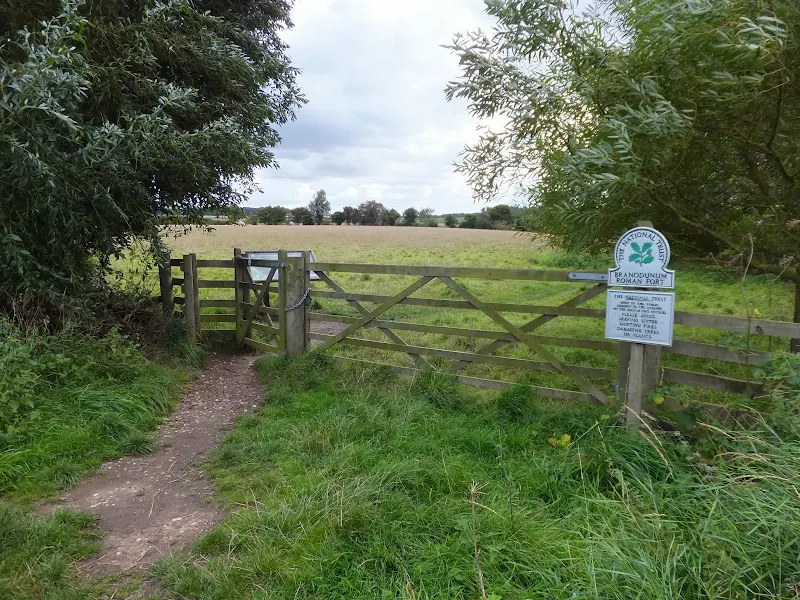
Brancaster is probably most renowned for being the location of the Roman fort named Branodunum. Such historic places usually invoke thoughts of the past, with the ghosts of them distant days being conjured up in ones mind. With such an antiquity there is always the expectation of being able to wander around and gaze upon its ruined walls and flint artefacts. Alas, this is not quite the case at Branodunum. The site sits on Rack Hill on the East side of Brancaster village and is accessible from the Coast Path. A National Trust post declares 'Branodunum Roman Fort' in capital letters under which it declares that it is open to the public. A kissing gate leads into this historic enclosure. Directly in front of the gate is an information board over which one can view the entire site. The board features a colour illustration of children intently discovering a model fort with accompanying information alongside it. One cannot help but look up from reading the words to cast ones eyes across the scene, only to witness a flat and somewhat un-stimulating grass field. No fort. No ruins. No bumps or mounds masking the foundations of long decayed structure. No scattered debris. Not even a model. Just a few sheep munching at the grass. It would seem this historical artefact was destroyed many centuries ago. Its stone carted away for other buildings and leaving very little. Well nothing really. It has somewhat lost its connection with the past and its ghosts of yesteryear have long since departed. Factually interesting but not a place one can drift back through the centuries and connect with different times. Just a marked reminder of what used to be here.
The walk is blessed with three pubs and a brewery. The White Horse and The Jolly Sailors, which hosts the brewery, are directly accessible from the Coast Path with marker posts at the appropriate place. Both of these pubs serve the Brancaster brewery beers, which started brewing in 2009 and continues a long tradition of brewing in the area. At the end of the walk, opposite the Brancaster church is The Ship Inn.
Directions
The path is simple and easy to follow, with the distinctive acorn National Trail waymarkers pointing out the route.
Follow the lane in front of the quay at Burnham Overy Staithe heading west and onto the Coast Road. keep to the Coast Road towards the windmill taking the field side path to avoid the actual road. The path then crosses a field and heads along the defence banks that surround Norton and Deepdale marshes. The bank ends at Burnham Deepdale where it continues along the edge of the marsh and in front of the houses that line the Coast Road. There are signs directing towards both the White Horse Inn and The Jolly Sailors pubs. Keep to the path all the way through until it meets Broad Lane at Brancaster. Turn left and follow the road until it meets the coast road by the church. The Ship Inn is opposite.
Pubs
White Horse, Brancaster Staithe View in OS Map | View in Google Map
- Address
- Main Road, Brancaster Staithe
- Website
- https://www.whitehorsebrancaster.co.uk/
The pub can be traced back to the 1830's although the present building dates from 1934. For a brief period in the early 1990s the name was changed to The Lobster Pot reverting back to The White Horse in 1997 when hotel bedrooms, a conservatory and a terrace were all added.
There is always a good range of ales including regular examples from the Brancaster Brewery, Woodfordes and Adnams plus an ever changing guest ale. An extensive restaurant menu offers a variety of home cooked food, with an emphasis on local seafood including mussels, crab, lobster, oysters, shrimp, sea bass, mackerel and sea trout dependant upon the season.
The white horse has changed in recent years. It has been spruced up in a minimalist style. A good range of ales and on this visit it had the splendid range of Adnams explorer, Woodfordes Wherry, Brancaster Brewery Oyster Catcher and Beeston Brewery's Village life. With the Brancaster Brewery just up the way we settled for the Beeston beer. An English bitter, hoppy with additional maltiness. It was interesting to note the inclusion of a bar billiards table, such items now becoming rare in the traditional English pub.
The Jolly Sailors, Brancaster Staithe View in OS Map | View in Google Map

- Address
- Coast Road, Brancaster Staithe
- Website
- https://www.jollysailorsbrancaster.co.uk/brancaster-brewery/
A traditional 18th century freehouse and home to the Brancaster Brewery which is housed on site. It is said that brewing at Brancaster Staithe dates back to Roman times and in 1797 the hamlet hosted the country's largest malthouse just yards from the pub which was reputedly constructed from stone taken from the Roman fort at Branodunum. The present brewery is a five barrel plant that produces a selection of ales although not all are available at any one time.
The rustic pub offers home cooked food, stone baked pizzas to eat in or take-away and local seafood. There is ample room outside in the gardens with a dedicated kids play area. The pub advertises that children, muddy boots and dogs are welcome.
It is always worth a visit to the Jolly Sailors, the beer is always good as is the food. It's a basic pub just like pubs should be.
Ship Inn, Brancaster View in OS Map | View in Google Map

- Address
- Church Street, Brancaster
- Website
- https://www.theshipbrancaster.uk/
The Ship Inn is instantly recongizable by the 6ft model ship that is pinned to the side of the building. Little is known about this model other than Sir Geoffrey Cory-Wright bought it some time around 1950 and even then it was reputedly 50 years old.
The pub is reputedly haunted by the ghost of Nelsons nurse although there are no references as to who has seen this phantom. It is known that the Nelson family had a nurse named Blackett, who eventually married the landlord of the Ship, a Mr High.
The pub is currently part of the Flying Kiwi Inns group, an independent concern created by Chef Chris Coubrough and includes various pubs and luxury hotels in Norfolk. Consequently there is a lot of emphasis on the food which is all prepared by award winning chefs from locally caught seafood, and locally sourced meat and vegetables.
Ales are supplied by Norfolk brewer JoC's (pronounced Josies), based at West Barsham near Fakenham.
Very quiet on this occasion. JoC's ale on offer and the Kiwi Ale is always a pleasure to drink
Features
Burnham Overy WindmillView in OS Map | View in Google Map
Burnham Overy Staithe Mill, which commands a position above the Burnham marshes, was constructed in 1816 by a miller known as Edmund Savory who also worked a watermill on the River Burn. The Burnham mill stayed within the Savoury family until 1900 when it was sold to Sidney Dewing. By this time it also had a steam engine to drive the four pairs of millstones. The mill lasted until 1914 as a working machine and eventually sold to an architect by the name of Hugh Hughes in 1926 who stripped the machinery and converted the structure into holiday accommodation.
Restoration of the mill was carried out in 1957 with a new cap and gallery, stocks and sails and then handed over to the National Trust. In 1978 the National Trust put forward plans to restore the mill to full working order which would act as a tourist attraction. Strong opposition by local people, together with a ruling verdict by Norfolk district Coucil to refuse the application spelt doom for the project on the grounds that the coast road was not adequate to cope with the number of visitors it was expected to generate. Therefore the mill was internally renovated and has since retained its identity as a holiday let.
References
BrancasterView in OS Map | View in Google Map
Writing in 1836, William White stated: Brancaster is a large scattered village, with a staithe or quay where the tide rises nine feet in a commodious creek, which crosses the salt marsh to that part of the ocean called Brancaster Bay, and enjoys a considerable trade in coal and corn.
Trade these days is gained from the numerous tourists and visitors to the village and from the mussels, lobsters and crabs which are brought to shore by the fishing smacks at Brancaster Staithe. In the times of William White's writings the parish had a population of 851 but that has now it has declined to 797.
Brancaster is probably most known for being the location of the Roman fort named Branodunum. The site is now a grassed field on the edge of the saltmarsh. Back in the 3rd century, the time it is thought that it was constructed, the land was on the shore and formed part of a chain of eleven forts between the Wash and Hampshire and commonly known as 'the Saxon Shore forts'. Little remains of this particular fort, its stone walls being demolished in the 18th century and used as building material for other constructions including the great malthouse.
Built in 1747, the Brancaster malthouse was the largest in Britain at the time being 104 yards in length by over 10 yards wide and boasting the largest malting trade in the country. The building, located at Brancaster Staithe, lasted until the early 19th century when it was demolished.
Other buildings that used the old fort material included Dial House which stands in the quay side at Brancaster Staithe and was constructed in the early 17th century. Now owned by the National trust, this building was once the Victory pub and incorporated its own brewhouse. It has since been the home to many wardens for the nature reserve and is currently a residential activity centre.
References
Image Gallery


Route Validation Cards
Validation Date - 2013-09-18
- Time of Walk: 11:30 to 14:30
- Validators: Griffmonster, Kat
- Weather Conditions: Bright blue skies and sunshine becoming somewhat overcast later
- Notes: Initial route undertaken
Summary of Document Changes
Last Updated: 2026-04-20
- 2014-11-07 : initial publication
- 2017-12-19 : general maintenance updates
- 2019-01-26 : general maintenance updates
- 2019-12-18 : general maintenance updates
- 2021-03-17 : Update website improvements and removal of ViewRanger reliance
- 2021-12-01 : Removal of ViewRanger links due to its imminent demise
- 2026-01-12 : Major website update with all walks recast to the new format


0 comments:
Post a Comment