Runton and Incleborough Hill Walk Sumary
Thursday, 30 August 2018
|
No comments
|
![]()
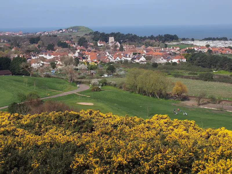
Short circular walk over Incleborough Hill in North Norfolk
Incleborough Hill stands above the villages of East and West Runton on the North Norfolk Coast. At 260 feet in height and covered with low level gorse bushes it provides magnificent unobstructed views across the coast from Cromer to Sheringhamm and beyond. One cannot help but be impressed and in awe at the sight.
The walk is not arduous and apart from a short climb up steps it is achievable by most able bodied folk. The return is down a much gentler slope to West Runton and to the coast to follow the Norfolk Coast path back to East Runton.

Walk Statistics
- Start location: East Runton
- Distance: miles ( km)
- Total Gain: ft ( metre)
- Total Descent: ft ( metre)
- Min Height: ft ( metre)
- Max Height: ft ( metre)
- Est. Walk Time:
- Walk type: Circular
- Walk Grade: easy
- Terrain: Footpaths, tracks.
- Obstacles: There is a short yet fairly steep climb up steps to the top of the hill

Maps
The following maps and services can assist in navigating this route. There are links to printed maps and links to downloadable GPX route data for importing into navigational software and apps.
- Ordnance Survey Explorer Map
- OS Explorer 252 - Norfolk Coast East
- GPX Route File
Accommodation
Woodhill Park CampsiteView in OS Map | View in Google Map
- Website
- https://www.woodhill-park.com/
- Description
- Located on the clifftops at East Runton, half way between Sheringham and Cromer, this highly recommended touring site is ideal for exploring North Norfolk with public transport available to many destinations from the entrance to the site.
Route Validation Cards
Validation Date - 2017-12-30
- Time of Walk: 10:00 to 12:00
- Validators: Griffmonster, Kat
- Weather Conditions: Clear blue skies
- Notes: Initial route undertaken
Summary of Document Changes
Last Updated: 2026-04-20
- 2021-03-17 : Update website improvements and removal of ViewRanger reliance
- 2021-12-01 : Removal of ViewRanger links due to its imminent demise
- 2026-01-12 : Major website update with all walks recast to the new format


0 comments:
Post a Comment