Weavers Way - Stalham to Aylsham Walk Summary
Saturday, 4 August 2018
|
No comments
|
![]()
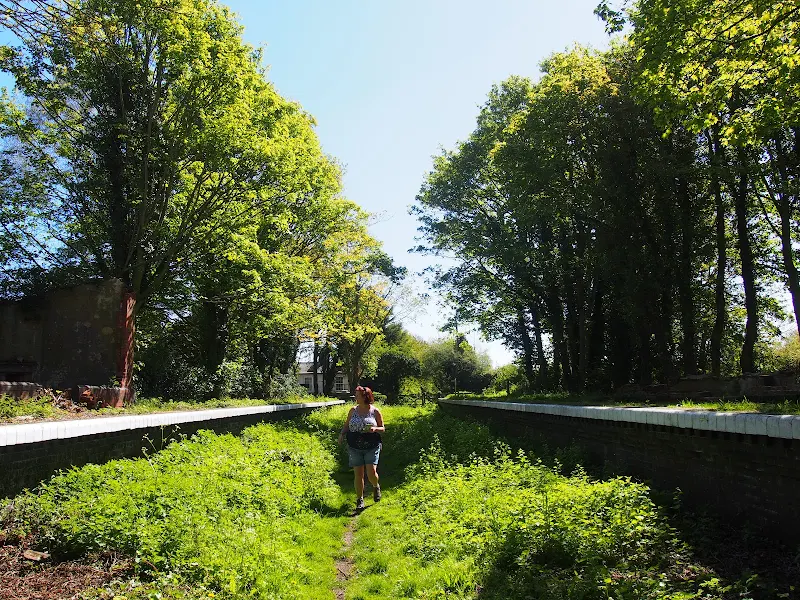
A walk along the dismantled M&GN railway from Stalham to Aylsham
This walk is the Railway section of the Weavers Way, a 60 mile long distance trail through the eastern side of Norfolk. This section follows the former M&GN railway trackbed from Stalham to Aylsham and there is plenty of evidence of the former railway with the stations of Honing and Felmingham still retaining their platforms and some structures and many typical railway style bridges throughout the trail.
Originally named as the Great Yarmouth and Stalham Light Railway when the first section was constructed in 1876, it changed its name to the Yarmouth and North Norfolk Light Railway with the extension to North Walsham in 1878. In 1881, in conjunction with the Lynn and Fakenham Railway a link between Melton Constable and North Walsham via Aylsham was added together with the light railway being converted to a full standard gauge line.
The 20th century saw this railway amalgamated into the Midland and Great Northern Railway, before combining into the LNER grouping. Post war saw its merger into the nationalised British Rail.
The line lasted until 1959 when it was deemed to be loss making and, along with many of Norfolk's railways, it closed down for good. The former railway line has now become part of the Weavers Way long distance trail as well as a designated county wildlife site and the cutting close to Felmingham has become a butterfly nature reserve.
The former railway has to be left at North Walsham where the modern road uses its route through the town. This provides a half way point of this walk and enables the hiker to peruse North Walsham as well as provide plenty of places to rest and refresh oneself before continuing onto Aylsham. The Hop Inn is always a recommended place to visit for those who like their ale. This micro pub serves six ever changing ales along with simple snacks and is always a hub of activity with conversation being the main entertainment of its customers.
There is no direct public transport link between the two ends of this walk and one requires to either use Cromer or Norwich as a link. In this instance Sanders Buses offers the number 6 service from Cromer to Stalham and to return there is the 44 servcie from Aylsham to Cromer.

Walk Statistics
- Start location: Stalham
- End location: Aylsham
- Distance: miles ( km)
- Total Gain: ft ( metre)
- Total Descent: ft ( metre)
- Min Height: ft ( metre)
- Max Height: ft ( metre)
- Est. Walk Time:
- Walk type: Linear
- Walk Grade: easy
- Terrain: The trackbed is fairly easy going throughout. The section around North Walsham uses country lanes and footpaths since the main road into town now uses the former route of the old railway.
- Obstacles: There are no major issues in walking this route although it should be noted that care should be tken at White Horse Common in crossing the Happisburgh road onto Field Road and the crossing of the main A140 close to Aylsham which is a very busy fast road.

Maps
The following maps and services can assist in navigating this route. There are links to printed maps and links to downloadable GPX route data for importing into navigational software and apps.
- Ordnance Survey Explorer Map
- OS Explorer 252 - Norfolk Coast East
- GPX Route File
Accommodation
Woodhill Park CampsiteView in OS Map | View in Google Map
- Website
- https://www.woodhill-park.com/
- Description
- Located on the clifftops at East Runton, half way between Sheringham and Cromer, this highly recommended touring site is ideal for exploring North Norfolk with public transport available to many destinations from the entrance to the site.
Route Validation Cards
Validation Date - 2018-05-05
- Time of Walk: 08:30 to 16:00
- Validators: Griffmonster, Kat
- Weather Conditions: Sunny day
- Notes: Initial route undertaken
Summary of Document Changes
Last Updated: 2026-04-20
- 2021-03-17 : Update website improvements and removal of ViewRanger reliance
- 2021-12-01 : Removal of ViewRanger links due to its imminent demise
- 2026-01-12 : Major website update with all walks recast to the new format


0 comments:
Post a Comment