Somerset Coast Path - Brean to Bridgwater
Sunday, 23 September 2018
|
No comments
|
![]()
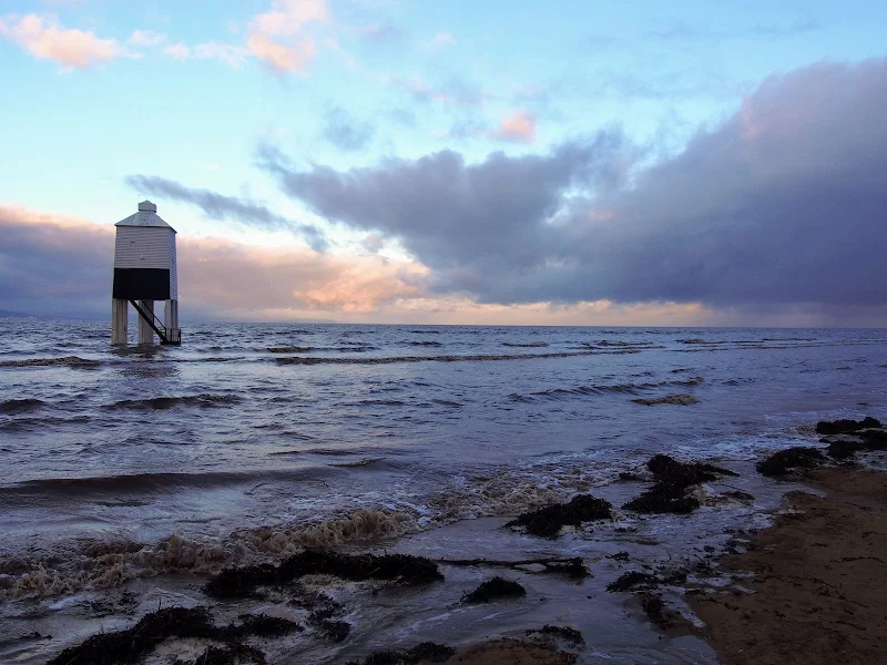
A walk along the Somerset Coast from Brean to Bridgwater
This walk starts by taking one of the many paths from the coast road through Brean to the broad sandy beaches that dominate this area. In this instance it uses the path opposite the Unity Holiday Camp, the name being taken from the former farm whose land it sits upon.
The England Coast path uses the beach all the way through to Burnham-on-Sea passing the iconic low lighthouse, a wooden structure that sits on stilts on the beach at the north end of Burnham. It is just past this landmark that one may find the path cut off by the tide. Don't attempt to go through to the sea wall ahead as there is no public access. Instead, take the path through the dunes and follow the track indicated on this route.
From Burnham the path follows the estuary of the River Parrett which rises some 37 miles away at Chedington in Dorset and is tidal for the majority of its course to the sea. All along this coast are the reminders of an industrial past. Burnham pier, which is no more than a stump these day, once was the railway terminus where both freight and passengers could be loaded onto ships. Burnham station was just across the road and what is now Marine Drive was the route of the od railway line from Highbridge. Reminders still adorn the roadside. The station sign. The old signalbox. A semaphore signal.
Soon after, as the path negotiates the marshes around the River Brue there are more reminders of the railway. This area was the Highbridge Wharf and used to house the Somerset and Dorset Joint Railway locomotive works. The works closed in 1930 and the Wharf is now no more than moorings for pleasure craft.
From this point there is a lengthy section following the winding estuary river where little is seen other than the wide open landscape. Make sure you have plenty of water and food. The grass river banks provide plenty of opportunity for a picnic.
Bridgwater town cannot be seen until one is in the town, its presence maske by the industrial outskirts. Dunball presents the first encounter of urbanisation where the path enters the old Dunball Wharf area and more reminders of its railway history with lines still sitting in the concrete ground. This was once a busy area and part of the Port of Bridgwater. As one will notice during this walk, the river is devoid of craft in the modern day and the docks and the railways are all just another chapter in history.

Walk Statistics
- Start location: Brean
- End location: Bridgwater
- Distance: miles ( km)
- Total Gain: ft ( metre)
- Total Descent: ft ( metre)
- Min Height: ft ( metre)
- Max Height: ft ( metre)
- Est. Walk Time:
- Walk type: Linear
- Walk Grade: moderate
- Terrain: Beach, prom and defence banks
- Obstacles: Just past the Burnham lighthouse, the beach may become impassable at high tides - if this is the case follow the route as shown on the map.
Just beyond the River Brue marsh, there is a kissing gate and two path choices, one descends down to a concrete prom by the waters edge. Avoid this as it is rough and suffers from incursion at high tide, take the path along the top of the defence bank.
At Dunball walk through the industrial area following the yellow marked route that has been painted on the ground

Maps
The following maps and services can assist in navigating this route. There are links to printed maps and links to downloadable GPX route data for importing into navigational software and apps.
- Ordnance Survey Explorer Map
- OS Explorer 140 - Quantock Hills & Bridgwater
- GPX Route File
Accommodation
Unity Farm, Brean Sands, Burnham-on-SeacampsiteView in OS Map | View in Google Map
- Website
- https://unityholidays.co.uk/
- Description
- A family oriented holiday park with entertainment, static caravans as well as touring pitches
Transport
First Group - Bus Service
- Service Details
- 21 - First Group 20 Service linking Weston super Mare, Brean and Burnham on Sea
- Timetable
- First Group (Bristol Bath and West) Website
First Group - Bus Service
- Service Details
- 21 - First Group 21 Service linking Burnam on Sea, Bridgwater and Taunton
- Timetable
- First Group (Somerset) Website
Route Validation Cards
Validation Date - 2018-09-09
- Time of Walk: 06:00 to 14:00
- Validators: Griffmonster, Kat
- Weather Conditions: clear day, sunshine
- Notes: Initial route undertaken
Summary of Document Changes
Last Updated: 2026-04-20
- 2021-03-17 : Update website improvements and removal of ViewRanger reliance
- 2021-12-01 : Removal of ViewRanger links due to its imminent demise
- 2026-01-12 : Major website update with all walks recast to the new format


0 comments:
Post a Comment