Route details, maps, pubs, features, local history and folklore for a wide variety of walks focusing primarily on Norfolk and Suffolk

Walks
Showing posts sorted by relevance for query Burnham-on-Sea. Sort by date Show all posts

Sunday 23 September 2018

Somerset Coast Path - Brean to Bridgwater

Salt marsh

A walk along the Somerset Coast from Brean to Bridgwater

This walk starts by taking one of the many paths from the coast road through Brean to the broad sandy beaches that dominate this area. In this instance it uses the path opposite the Unity Holiday Camp, the name being taken from the former farm whose land it sits upon.

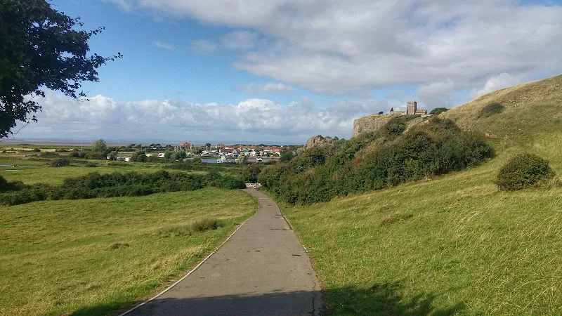
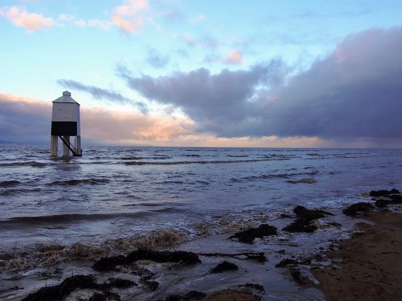
The England Coast path uses the beach all the way through to Burnham-on-Sea passing the iconic low lighthouse, a wooden structure that sits on stilts on the beach at the north end of Burnham. It is just past this landmark that one may find the path cut off by the tide. Don't attempt to go through to the sea wall ahead as there is no public access. Instead, take the path through the dunes and follow the track indicated on this route.

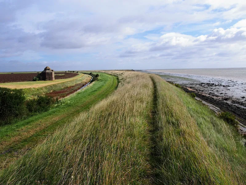
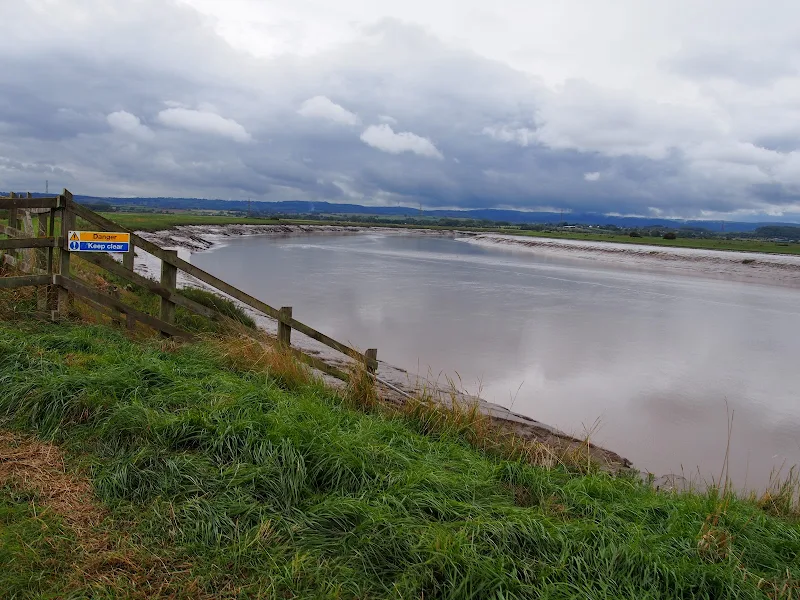
From Burnham the path follows the estuary of the River Parrett which rises some 37 miles away at Chedington in Dorset and is tidal for the majority of its course to the sea. All along this coast are the reminders of an industrial past. Burnham pier, which is no more than a stump these day, once was the railway terminus where both freight and passengers could be loaded onto ships. Burnham station was just across the road and what is now Marine Drive was the route of the od railway line from Highbridge. Reminders still adorn the roadside. The station sign. The old signalbox. A semaphore signal.

Soon after, as the path negotiates the marshes around the River Brue there are more reminders of the railway. This area was the Highbridge Wharf and used to house the Somerset and Dorset Joint Railway locomotive works. The works closed in 1930 and the Wharf is now no more than moorings for pleasure craft.

From this point there is a lengthy section following the winding estuary river where little is seen other than the wide open landscape. Make sure you have plenty of water and food. The grass river banks provide plenty of opportunity for a picnic.

Bridgwater town cannot be seen until one is in the town, its presence maske by the industrial outskirts. Dunball presents the first encounter of urbanisation where the path enters the old Dunball Wharf area and more reminders of its railway history with lines still sitting in the concrete ground. This was once a busy area and part of the Port of Bridgwater. As one will notice during this walk, the river is devoid of craft in the modern day and the docks and the railways are all just another chapter in history.

Sunday 26 August 2018

Essex Coast - Burnham-on-Crouch to Bradwell Walk Summary

Salt marsh

A 15 mile walk along the remote Essex coast from Burnham-on-Crouch to Bradwell

Many publications have stated that the section of the Dengie peninsular that borders the sea, east of the town of Burnham-on-Crouch, is the most remote place in the entirety of England. It is true that this isolated area of Essex is far from any major centres of population but walking this coast path one is never completely devoid of the signs of civilisation. Although one may never meet another soul on this lonely path, there are farms and machinery working the fields, haystacks and narrow lanes heading inland. All evidence that civilisation is not far away and, indeed, the nearest town is never more than 5 miles away as the crow flies.

The route is predominantly defence banks with a panorama of flat marsh to one side and acres of flat farmland on the other leaving with just the defence bank the tallest structure around. This leaves one distinctly exposed to the elements and faced with wind and rain it can require additional effort to push onwards. There are wide areas of cut grass on the landward side of the banks which can be utilized as a sheltered walking refuge when the going becomes a struggle or when the top of the bank is overgrown as found it some sections in this instance.

It has to be said that the constant unchanging scenery of this flat landscape can become somewhat monotonous as the miles slowly slip away. The smallest of landmarks then become a haven for curiosity. A sluice gate. A WWII pill box. Discarded tyres and debris in the marsh mud. The skeletal remains of a ship rotting on the marsh. A metal 5 bar gate with numerous plastic pieces of jetsom and flotsam seemingly purposely tied to it cluttering the mind with wonder as to its intentions.

The final part of the walk leaves the coast to navigate up the lanes to the village of Bradwell. There is a bus service from here although buses are few and far between. The D4 service returns to Burnham-on-Crouch. The alternative, as in this instance where accommodation was at St Lawrence is the D1 Service which links Bradwell, St Lawrence and the village of Latchingdon where the regular 31 service proceeds to Burnham-on-Crouch.

Monday 26 February 2018

A Norfolk Ramble around the Burnhams

Holkham Hall lake

A 16 mile circular walk from Wells-next-the-sea taking in Burnham Thorpe, Burnham Market and Burnham Norton

This full days walk has everything to offer the adventurous rambler. There is a wander through the stately grounds of Holkham Hall in order to reach the humble church at Burnham Thorpe with its tributes to Norfolk's most famous son, Lord Nelson who was born and grew up in the area. Country lanes lead down to Burnham Market and the church of the old parish of Burnham Ulph. Heading down to the coast there is the church of Burnham Norton with its resplendent medieval paintings. The ramble returns along the vast expansive beaches in front of Holkham.

Tuesday 24 December 2019

Norfolk Coast Path - Wells-next-the-Sea to Burnham Overy Staithe

Burnham Overy Staithe

A 7 mile walk following the North Norfolk Coast Path between Wells-next-the-Sea and Burnham Overy Staithe

This amble includes some magnificent beach walking along the sands in front of the Holkham National Nature Reserve. Acres upon acres of golden sand when the tide is out with big skies and thousands upon thousands of razor shells which are washed up on the high tide mark. The walk ends at Burnham Overy Staithe, the quiet hamlet which is said to be where Nelson learnt to row and sail.

Wednesday 18 December 2019

Norfolk Coast Path - Burnham Overy Staithe to Brancaster

Brancaster Staithe Quay

A 6 mile walk following the North Norfolk Coast Path between Burnham Overy Staithe to Brancaster

Wide open areas of marshland provide an enticing setting for this easy walk. Sailing boats, marsh, a tidal pool and the site of a Roman fort provide plenty of interest, together with three pubs, what more could one ask for of an afternoons stroll.

Wednesday 3 October 2018

Brean Down Way - Weston-super-Mare to Brean

Salt marsh

Brean Down Way - Weston-super-Mare to Brean

This route makes use of a cycle path known as the Brean Down Way that links Weston Super Mare to Brean Down. Opened in May 2017, this provided a cross country route that made use of a crossing of the River Axe at a sluice gate that previously had no public access. In addtion paths have been installed alongside the road sections making for a pleasant and easy walk accessible to all.

Leaving Weston one passes through Uphill with its iconic church that dates from 1080 sitting above the path atop a rocky cliff. Although paritally ruined it does have a roofed chapel that is still in use for Christian services. There is then a asphalt path that leads through to the sluice and a new path that leads around the perimeter of a caravan park and then along the road to Brean Beach. The Brean Down Way then heads north to Brean Down and this route heads south along the glorious wide sandy beaches to the southern sid of Brean

Tuesday 17 December 2019

A Walk to Brancaster Beach

Brancaster Beach

A 3 mile walk out to Brancaster Beach returning across the marsh to Titchwell

Although not included in the official Norfolk Coast Path route, this simple walk is a well worth excursion to witness the expanse of sand and dune as well as a petrified forest and an old wreck. Always be mindful of tide conditions and particularly do not attempt to get across to the wreck which lies across the Harbour channel.

Tuesday 25 September 2018

Somerset Coast Path - Bridgwater to Cannington

Salt marsh

A walk along the banks of the River Parrett from Bridgwater to Cannington

This 9 mile walk is part of the Somerset section of the England Coast Path and follows the defence banks of the River Parrett from Bridgwater to Cannington. Although the village of Cannington is not exactly on the river, it does provide a public transport link back to Bridgwater and there are clear paths and tracks that link the trail to the village.

The River Parrett at this point is a wide tidal estuary with long slow winding bends in its course as it navigates to the sea. WWII Pill boxes sit around each bend, strategically placed to guard against the threat of German invasion up the river. The fields on either side are pastureland for cattle and sheep and once beyond Dunball there is little sign of civilisation. The river is notable for its lack of craft, the docks of Bridgwater and Dunball, collectively known as the Port of Bridgwater, are now long gone so no commercial traffic utilizes the water course. Even pleasure craft are notable by their absence.

It should be noted that at the time of this walk report, September 2018, there was a series of works along the river bank necessitating marked diversions. According to the order notices these works will be in place until mid 2019. The diverted paths are not immediately clear and one should follow the roped lines and the seemingly out-of-place red road signs that direct pedestrians.

The route from the defence banks to Cannington uses a footpath clearly marked on OS Maps. It should be noted that this path is a some distance beyond where it is marked on the map and one should continue to the field boundary where there is a stile, then follow the farm track.

As with many defence paths, the grass banks in this instance were in particular need of a trim. Overnight rain had left the vegetation sodden resulting in very wet feet. No matter how many times boot manufactures indicate their footwear is waterproof, experience proves that no boot is completely waterproof. Just remember that it is only water and feet and boots soon dry out. Just enjoy the walk, the seclusion and the landscape.

Tuesday 2 October 2018

Somerset Coast Path - Cannington to Watchet

Salt marsh

An extensive hike along the Somerset Coast path from Cannington to Watchet

This is an extensive 20 mile hike along the Somerset coast from the village of Cannington on the Parrot Estuary to Watchet, sitting under the Quantock hills on the coast. The extent of this walk is down to the lack of public transport in the area making it difficult to walk smaller sections without some kind of personal transport or taxi assistance to link up the ends. Even this walk is limited by the fact that there is only a single bus journey each day and that only runs weekdays during college term, departing at 7:40 from Watchet railway station.

Having outlined the negative aspects then it should be stated that this is an outstanding walk over varied terrain. The walk begins along the River Parrett and heads out alongside the marshes towards Steart Point. There is an option to continue to the point although this would add an additional 4 miles to the distance. This route follows a short cut to omit this, and cuts across to the coast up to Hinkley Point Power Station.

At this point there is a long term diversion in place due to the building works for the construction of Hinkley Point C, the first UK nuclear power station to be constructed in many decades. The diverted paths are well maintained with convenient waymarkers in place throughout the 3 mile diversion. The site is extensive with some massive earth works being undertaken and all the noise and hubbub associated with such sites.

On the western side of the power station the landscape changes as the path negotiates the coastal section at the foot of the Quanktock hills. Cliffs and valleys are encountered and two beach sections need to be negotiated, one at St Audreys Bay and another at Helwell Bay, where fossils can be easily found amongst the large stones and pebbles. Do take note of the tide times as access to both beaches is limited by the tide which makes both beach routes impassable. During high tides a marked alternative inland route is provided and there is ample signage to warn the walker of progressing along the beaches during such conditions.

Wednesday 19 September 2018

Brean Down Circular Walk

Salt marsh

A Short walk around Somersets Brean Down

Brean Down is a 100m high promontory at the northern end of the Somerset Coast Path. This rocky outcrop protrudes some 1.5 miles out into the Bristol Channel and centred between the sandy bays of Brean and Weston Super Mare. The land is currently owned by the National Trust and provides both wildlife habitat and the remains of a Victorian fort, recommissioned in WWII, that sits at the head.

The walk is under 3 miles in total. There is a steep initial climb although this is up well maintained steps that most able bodied folk can negotiate. The effort is rewarded by the amazing views from the top with a panoramic scene stretching along the coast southwards with the distant Quantock hills making way for the tall cliffs of Devon. Northwards gives views of the extensive beaches around Weston Super Mare and to the west are the islands of Flat Holm and Steep Holm with Barry Island marking the closest point on the welsh coast beyond.

The Fort at the end of the promontory is maintained by the National Trust with information boards throughout and representatives on hand to offer guidance and information. Entrance is free and one can spend a good hour just wandering through these extensive remains.

Wednesday 3 October 2018

Somerset Coast Path - Minehead to Watchet

Salt marsh

An easy ramble along the Somerset Coast Path between Minehead and Watchet

This is a scenic and easy walk along the Somerset Coast Path between Minehead and Watchet with connections between the ends provided by either bus service or the heritage railway that follows the route.

Parking in this area of Somerset is expensive and an alternative is to make use of the ample free parking along the coast road at the hamlet of Blue Anchor, midway along the route.

The walk encompasses a varied scenery from the flat open areas of Dunster Beach to the rolling hills between Blue Anchor and Watchet which require a little effort to ascend but are nothing too challenging. There are some beach sections although a cycle track provides an easier option from the hard going across the large pebbles

It must be noted that on this instance of the walk during September 2018 there had been cliff fall just beyond the Blue Anchor pub at the eastern end of the hamlet of the same name which had blocked the path. This necessitated following a waymarked diversion along permissive paths that follow the roadside then descend down to the cliffside through the woods known as Three Acre Covert. A stroll that made a pleasant change of scenery.

Beach walk from Brean village to Brean Down

Salt marsh

Beach walk from Brean village to Brean Down

A glorious walk across the acres of sand that make up Brean beach. This is the clasic British beach walk where the sea ebbs away into the distance at low tide leaving a vast expanse of compacted sand to walk across. With the promontory of Brean head jutting out to the north and the island of Steep Holm lurking in the distance it makes for some interesting views.

Return can either be directly back along the sands which offer firm sand even at most high tides, or along the beach road where there are ample bars and restaurants that accompany the numerous holiday camps that adorn this area.

Probably the best time to walk this beach is early morning when the beach is devoid of people and the dawn is breaking from the landward side. With a moody sky where clouds deflect the sunlight in every direction then this beach becomes a true wonder to walk along.

Walk Summaries

Latest walk summaries are basic information sheets for walks that have yet to be fully documented. These provide links to maps, public transport and walks stats, although detailed notes and features are not included.

Latest Walk Summaries

Featured Walk

In Search of Sizewell Chapel

A 10 mile walk following the southern side of the parish boundary of Leiston in Suffolk This walk follows the route of a 17th century peramb...

What is GPX

All you need to know about GPX, electronic mapping and how to use modern apps and mobile devices as navigation devices

Popular Walks

Maps