Essex Coast - Burnham-on-Crouch to Bradwell Walk Summary
Sunday, 26 August 2018
|
No comments
|
![]()
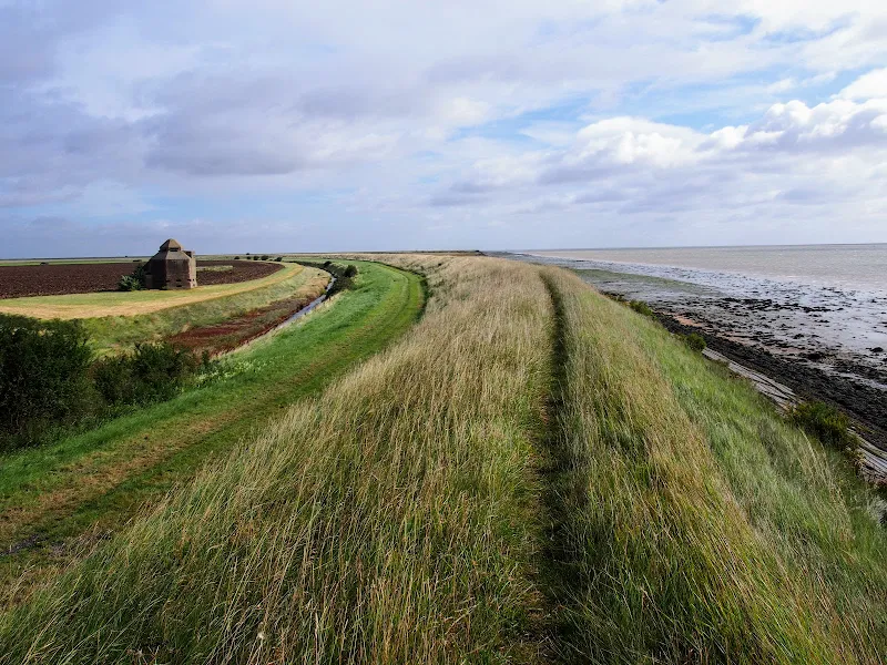
A 15 mile walk along the remote Essex coast from Burnham-on-Crouch to Bradwell
Many publications have stated that the section of the Dengie peninsular that borders the sea, east of the town of Burnham-on-Crouch, is the most remote place in the entirety of England. It is true that this isolated area of Essex is far from any major centres of population but walking this coast path one is never completely devoid of the signs of civilisation. Although one may never meet another soul on this lonely path, there are farms and machinery working the fields, haystacks and narrow lanes heading inland. All evidence that civilisation is not far away and, indeed, the nearest town is never more than 5 miles away as the crow flies.
The route is predominantly defence banks with a panorama of flat marsh to one side and acres of flat farmland on the other leaving with just the defence bank the tallest structure around. This leaves one distinctly exposed to the elements and faced with wind and rain it can require additional effort to push onwards. There are wide areas of cut grass on the landward side of the banks which can be utilized as a sheltered walking refuge when the going becomes a struggle or when the top of the bank is overgrown as found it some sections in this instance.
It has to be said that the constant unchanging scenery of this flat landscape can become somewhat monotonous as the miles slowly slip away. The smallest of landmarks then become a haven for curiosity. A sluice gate. A WWII pill box. Discarded tyres and debris in the marsh mud. The skeletal remains of a ship rotting on the marsh. A metal 5 bar gate with numerous plastic pieces of jetsom and flotsam seemingly purposely tied to it cluttering the mind with wonder as to its intentions.
The final part of the walk leaves the coast to navigate up the lanes to the village of Bradwell. There is a bus service from here although buses are few and far between. The D4 service returns to Burnham-on-Crouch. The alternative, as in this instance where accommodation was at St Lawrence is the D1 Service which links Bradwell, St Lawrence and the village of Latchingdon where the regular 31 service proceeds to Burnham-on-Crouch.

Walk Statistics
- Start location: Burnham-on-Crouch
- End location: Bradwell
- Distance: miles ( km)
- Total Gain: ft ( metre)
- Total Descent: ft ( metre)
- Min Height: ft ( metre)
- Max Height: ft ( metre)
- Est. Walk Time:
- Walk type: Linear
- Walk Grade: moderate
- Terrain: The majority of the walk is on grass topped defence banks although there are some sections of concrete defences.
- Obstacles: This is a remote area and there are no facilities throughout this walk. Take enough food and water for a full days walk.

Maps
The following maps and services can assist in navigating this route. There are links to printed maps and links to downloadable GPX route data for importing into navigational software and apps.
- Ordnance Survey Explorer Map
- OS Explorer 176 - Blackwater Estuary
- GPX Route File
Accommodation
Waterside ParkcampsiteView in OS Map | View in Google Map
- Website
- https://www.parkdeanresorts.co.uk/location/essex/
- Description
- Parkdean resorts Waterside Park on the banks of the Blackwater estuary. This was taken over by Countrywide Park Homes in December 2017 amid accusations of intimidation towards holiday park plot owners. It is uncertain whether touring sites are still available here. Certainly during Autumn 2017 the site was amenable and the staff accommodating. More recent Trip Advisor reports since the take over are not encouraging.
Transport
Hedingham - Bus Service
- Service Details
- D1 - The D1 service links Bradwell, St Lawrence, Maylandsea, Latchingdon and Maldon. This is a limited service which appears to get cut back each year. As of 2018 it was run by Hedingham Coaches but may well change in the future
- Timetable
- Essex Bus Timetables
Hedingham - Bus Service
- Service Details
- D4 - The D1 service links Bradwell, Tillingham, Southminster and Burnham-on-Crouch. This is a limited service which appears to get cut back each year. As of 2018 it was run by Hedingham Coaches but may well change in the future
- Timetable
- Essex Bus Timetables
First Group - Bus Service
- Service Details
- 31B/31X - First Group Essex buses 31B/31X service linking Chelmsford, Maldon, Latchingdon, Southminster and Burnham-on-Crouch
- Timetable
- First Group (Norfolk and Suffolk) Website
Route Validation Cards
Validation Date - 2017-09-11
- Time of Walk: 07:30 to 14:00
- Validators: Griffmonster, Kat
- Weather Conditions: blustery day with light showers
- Notes: Initial route undertaken
Summary of Document Changes
Last Updated: 2026-04-20
- 2021-03-17 : Update website improvements and removal of ViewRanger reliance
- 2021-12-01 : Removal of ViewRanger links due to its imminent demise
- 2026-01-12 : Major website update with all walks recast to the new format


0 comments:
Post a Comment