SWCP - Portland Circular Walk
Thursday, 11 April 2019
|
No comments
|
![]()
A 13.5 mile walk along the South West Coast Path around the Isle of Portland
A fascinating wander around the Isle of Portland, the peninsular that lies on the southern tip of Weymouth. Not overly challenging but with a few climbs and descents. The coastline is full of the relics and remnants of the quarries where the renowned Portland Stone was extracted. The tip of the island features the Portland Bill lighthouse and is a major tourist attraction in this part of the world, although few of these visitors take the coast path to get there.

Walk Statistics
- Start location: Ferrybridge
- Distance: miles ( km)
- Total Gain: ft ( metre)
- Total Descent: ft ( metre)
- Min Height: ft ( metre)
- Max Height: ft ( metre)
- Est. Walk Time:
- Walk type: Circular
- Walk Grade: Easy
- Terrain: Footpaths, tracks
- Obstacles: Not too challenging

Maps
The following maps and services can assist in navigating this route. There are links to printed maps and links to downloadable GPX route data for importing into navigational software and apps.
- Ordnance Survey Explorer Map
- OS Explorer OL15 - Purbeck and South Dorset
- GPX Route File
Accommodation
Bagwell Farm Camp SiteView in OS Map | View in Google Map
- Website
- https://bagwellfarm.co.uk/
- Description
- Touring site close to the main road with easy access to the coast Path
Transport
Traveline - Bus Service
- Service Details
- At the time of walking the X53 Jurassic Coastlinx service provide a link between Weymouth and Langton Herring. Local Weymouth buses also run out to Chickerell (First Group Service 8 at the time of walking). This is about a mile from the campsite. For the latest details of services and operators see the Traveline website
- Timetable
- https://www.traveline.info/
Walk Notes
This walk begins and ends at Ferrybridge, the Weymouth side of the thin strip of land that connects the southern tip of Weymouth with the Isle of Portland. The path then leads past Portland Castle before ascending up to the eastern side of the village of Fortuneswell. This isn't strictly a coastal route at this point as the path heads towards the highest point of the island, navigating around the southern side of Portland Prison. This was constructed in the 19th century as a citadel, a defensive fortification that was naturally defended to the north and east with steep cliffs. Consequently the coast path has to navigate around the west and southern edges. The fortress ended as a defensive structure in 1903 although it was subsequently used during both world wars as barracks, after which, in 1949, it became a prison.
The trail descends through leafy paths down to the coastline where it navigates around the rocky and ragged cliffs, passing through former quarries used to extract the famous Portland Stone, a limestone that has been used for many building projects over the centuries including St Paul's Cathedral and Buckingham Palace. In the distance, across the water, are the cliffs of Dorset, with views all the way through to Lulworth Cove and beyond, and as was the case on this occasion, small mushroom clouds intermittently arose from above the cliffs, evidence of practice bombing on the coastal military range.
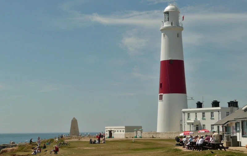
The walk culminates in reaching Portland Bill with its iconic lighthouse where a South West Coast Path marker boldly declares 49 miles to Poole and 581 miles to Minehead. On the very tip of this promontory is an obelisk which was constructed in 1844 by Trinity House as a daymark for passing shipping. A little way around from this is Pulpit Rock, a relic from the quarrying days when in 1870 an arch was cut in the rock by the quarrymen. The resulting structure is said to resemble an open bible resting on a pulpit. This whole area at the top of Portland is a renowned tourist destination and consequently there is the opportunity to find refreshment before navigating around the western side of the island.
The return route is a fairly easy ramble along the grassy cliff tops. Eventually it negotiates the ledge around the perimeter of Blacknor Fort and on into the Tout Quarry Sculpture Park. This area is a former stone quarry dating back to the 18th century which has been transformed into a nature reserve with an abundance of large stone sculptures that are fascinating, thought provoking and at times, almost comical, bringing a smile to the face of anyone who unexpectedly encounters them.

Finally one descends back down to the bridge of land back to Weymouth but not before a final gaze across to Ferrybridge and the huge shingle bank that forms Chesil Beach disappearing into the distance. This is truly an awe-inspiring walk and thoroughly enjoyable.
On a more personal note, this walk was undertaken using a base camp at Langton Herring, namely the Bagwell Farm campsite, and local bus services to and from Portland. The return to site was delayed after a further late afternoon walk and a few pubs were visited on the return route. Starting in central Weymouth there is a prominent Wetherspoons house named The William Henry which hosted a selection of ale including a local brew from Palmers brewery, a very drinkable, thirst quenching Dorset Gold!
The return bus journey took us through to the town of Chickerell where The Lugger Inn proved to be a good pub discovery. This was only visited on account of a requirement of toilet facilities and once relieved followed by the aptly named pint of Piddle together with a Lugger Ale. A pint of Piddle resulted in another trip to the loo. Piddle in, piddle out.
Finally a visit was paid to The Victoria Inn, an unassuming pub on the main road back to Langton Herring with the alternative name of The Knights in the Bottom which is a Chivalric order that was not encountered in Monty Pythons Holy Grail. Maybe the order should have been included, and one can imagine the scene with a voice emanating from an unseen source, Halt, who goes there, we are the Knights in the Bottom
, a lot of wandering of eyes results until the voice pipes up again, over here you stupid persons, up here in the bottom,
and a quizzical Knights of the Round Table cautiously peer into an anus shaped cave from which an enormous fart exudes. The Knights in the Bottom have been found.
Unfortunately on this occasion not even a voice was heard, let alone a cave in the shape of an anus. Even on entering the pub there was no sign of a single Knight in the Bottom, and the small group of men and women huddled around the bar certainly did not look Chivalric. We come in a quest
was the appropriate introduction to the barman. It did not seem to matter, whether we came in a quest, a bus or a Ford Escort all the barman wanted to know was what we wanted to drink.
The group around the bar started a conversation. They certainly were not on a quest but one of them hailed from a small Northamptonshire town named Rushden. Now that is a coincidence for that is the same town from which I hail. And to top this, the man was a former physio to Rushden Town Football Club, the club I had followed since pre teen days, and have continued to follow throughout their colourful history of merging to become Rushden and Diamonds and hitting the heights of league football before recreating themselves as AFC Rushden and Diamonds. Of all the pubs in all the world I had to walk into the pub where the former Rushden Town physio drank. It is a small world, albeit with no sign of any Knights in the Bottom!
Route Validation Cards
Validation Date - 2010-06-23
- Time of Walk: 09:30 to 14:00
- Validators: Griffmonster, Kat
- Weather Conditions: Bright sunshine and hot
- Notes: Initial route undertaken
Summary of Document Changes
Last Updated: 2026-04-20
- 2010-06-30 : Initial publication
- 2019-04-13 : Recast and rewritten to common website format - separated out from a common two walk post
- 2021-03-17 : Update website improvements and removal of ViewRanger reliance
- 2021-12-01 : Removal of ViewRanger links due to its imminent demise
- 2026-01-12 : Major website update with all walks recast to the new format


0 comments:
Post a Comment