Stour and Orwell Walk - Ipswich to Shotley Gate
Tuesday, 4 May 2021
|
No comments
|
![]()
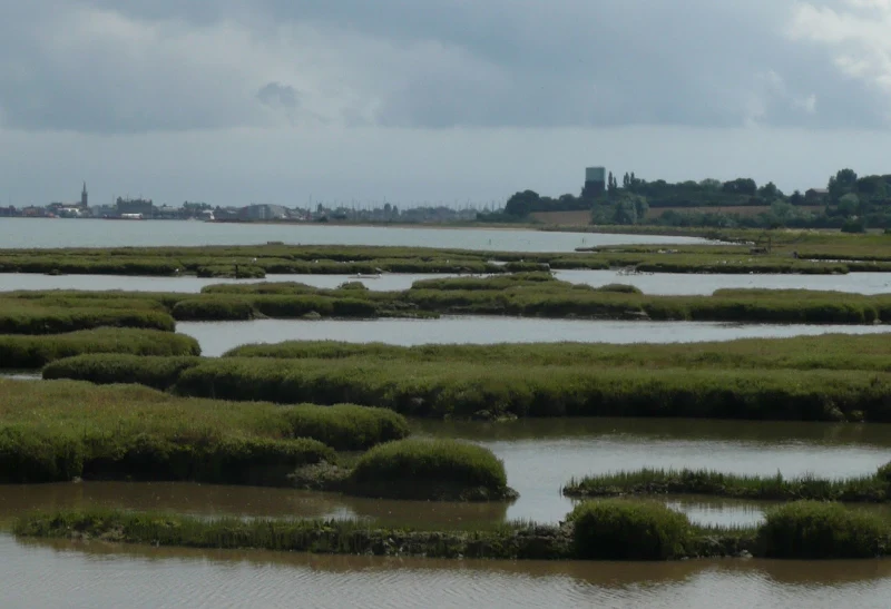
A 14 mile walk along the banks of the River Orwell in Suffolk between Ipswich and Shotley Gate
The Stour and Orwell path is an extension to the southern end of the Suffolk Coast Path and follows the coast and heaths along the estuaries of the Orwell and the Stour rivers. This particular walk focuses on the section between Ipswich and Shotley Gate following the river Orwell along the Shotley peninsular.

Walk Statistics
- Start location: Ipswich
- End location: Shotley Gate
- Distance: miles ( km)
- Total Gain: ft ( metre)
- Total Descent: ft ( metre)
- Min Height: ft ( metre)
- Max Height: ft ( metre)
- Est. Walk Time:
- Walk type: Linear
- Walk Grade: Easy
- Terrain: Footpath, Country Lane

Maps
The following maps and services can assist in navigating this route. There are links to printed maps and links to downloadable GPX route data for importing into navigational software and apps.
- Ordnance Survey Explorer Map
- OS Explorer 197 - Ipswich, Felixstowe & Harwich
- GPX Route File
Walk Notes
The Stour and Orwell Walk is an extension to the southern end of the Suffolk Coast Path where it continues from Languard Fort, following the banks of the River Orwell through to Ipswich then continuing around the Shotley peninsular. This specific walk focuses on the section from Ipswich to Shotely Gate, navigation down the Orwell estuary. The walk mixes countryside and estuary, marsh and defence banks. There is constant views of passing shipping and pleasure craft to provide a constant source of inspiration.
On 16 October 2024 the King Charles III England Coast Path was opened to the public for the section between Shotley Gate and the Orwell Bridge. This uses most of the paths documented on this walk. A GPX of that route can be found on the page England Coast Path - Shotley Gate to Orwell Bridge.
When Griffmonster Walks undertook this walk, the day was decidedly uninviting, and despite some warmth in the air the first half of the walk was undertaken in a persistent light rain. This is reflected in the images with this write-up, which may not entice you to follow this route. Despite this I can assure anyone contemplating this walk that the experience is well worth the effort. Find a sunnier day and it will impress, as it has to be said, that despite the gloom on this occasion, being out there in the elements provided a great day out.
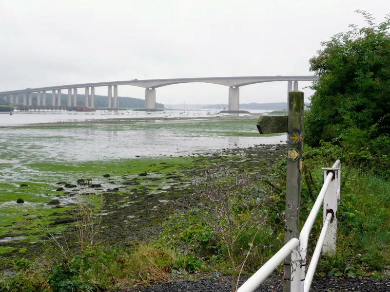
The route begins with passing through some urbanized outskirts of Ipswich, not the best of walk highlights but this is soon to the back of us. Once one gets to the roundabout with the Wherstead road, the path turns to the shores of the estuary with the massive Orwell bridge dominating the view. This concrete structure is some 1,287 metres in length, that is 0.8 miles in old money, and was constructed at the start of the 1980s. As well as the traffic it also allows those who are walking the Orwell and Stour walk to pass over the estuary for those who do not want to progress into Ipswich.
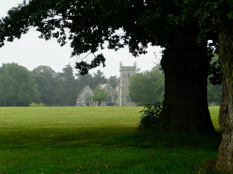
The path passes under the bridge and then follows the riverside road before taking an excursion away from the river. The route leads up the slow hill away from the water, taking in woodland and open fields around the villages of Freston and Woolverstone. This diversion is required in order to avoid Freston Park, a private riverside site of ancient woodland with no public access. Nevertheless the inland ramble passes the churches of Freston and Woolverstone to provide a little historic interest. A church of St Peter at Freston was recorded in the Domesday Book but the building one sees today is a Victorian restoration with little of the original structure surviving and even the stained glass windows only date from the 1920s. St Michaels at Woolverstone shares a similar history of being recorded in the Domesday Book and a Victorian restoration, however the building does have a surviving 15th century tower.
There is an interesting piece of folklore about the name of the village of Woolverstone. It is said that the church stands on a large glacial stone, held sacred by the old Saxon inhabitants. During these historic times, East Anglia was frequently the subject of Viking raids and it was one of these, led by the chieftain named Wulf, that came up the Orwell estuary to plunder the towns and villages. During this invasion it is said that Wulf himself sacrificed a maiden upon this sacred stone. Sometimes this is a maiden, sometimes a poor local depending upon the telling of the tale. Whatever version is related, this act is said to have been where the name Woolverstone originated, quite simply Wulfs Stone. Academic sources beg to disagree, and would interpret the name as old English from Wulfhere's farm or settlement.
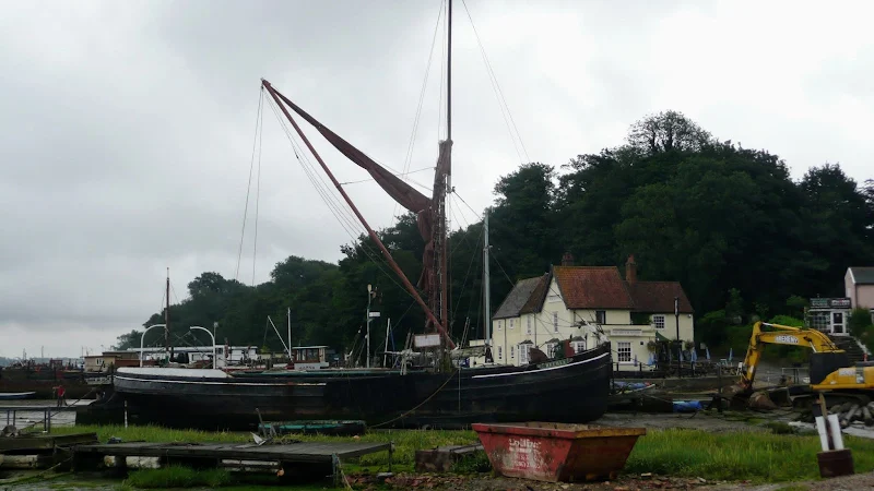
From Woolverstone the path navigates back down to the shores of the estuary at Pin Mill where the Butt and Oyster pub provides a place to take some rest and refreshment in this charming hostelry whose walls are lapped by the waters of the Orwell. The present building dates from the 17th century but there are records from 1456 when court hearings were held upon the premises which suggests a building preceded the present structure. The pub name is derived from the barrels that were used to transport oysters, a butt being an English measure of liquid volume, equivalent to 108 gallons, or two hogsheads or 12 firkins, the present day volume for most beer deliveries.
The pub is currently owned by Deben Inns and offers a selection of Adnams ales and a varied food menu. The pub is very popular but it is a place not to miss, and the only place of refreshment until the end of the walk.
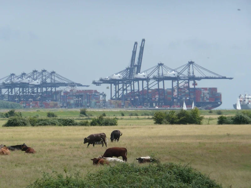
The second half of this walks starts with a ramble through the Cliff Plantation, an area of woodland along the cliffside of the estuary. This is followed by a lengthy hike along the riverside marshes and defence banks. This provides great views across the estuary where the eye is caught by the regular passing of river craft. The riverside marsh is full mud bank formations which entice the birdlife to scavenge on the revealed mud as the tide ebbs. There is always something to see, something to catch ones eye. As the course of the river turns, Felixstowe docks comes fully into full view, dominating the horizon with its huge cranes and container ships, dwarfing the nature below. Then as the path draws level with this 20th century monument to global trade, Shotley Marina reveals itself, full of luxury yachts, their tall masts standing and clattering in the breezes.
Finally, a, wander around the head of the peninsular brings one to Shotley Gate, the name of the hamlet that resides here, although almost lost in the boating community structures. Beyond is the sea, with Felixstowe the dominant scene to the left and in the distance on the right is Harwich and the county of Essex. The 600ft long Shotley pier stretches out into the water. Constructed in 1894 and constructed by the Marquis of Bristol in 1894, it was used to transport Mail to the ferry bound for Harwich. It looks in a sorry state these days although the Shotley Hritage Community have plans to revive it to its former glory.
A ferry service connects Felixstowe, Harwich and Shotley Gate. For those needing to connect to Felixstowe, the crossing is via Harwich, with a total journey time of just under half an hour.
We end the walk with a deserved pint of beer at The Shipwreck, a modern bar and restaurant that is part of the marina complex, that looks out across the seafront.
Ipswich Buses run a service that links Shotley Gate and Ipswich and the bus stop is just around the corner of the road that leads up to Shotley village, opposite the Bristol Arms pub.
Route Validation Cards
Validation Date - 30/07/2010
- Time of Walk: 10:00 to 15:00
- Validators: griff, kat
- Weather Conditions: warm summers day
- Notes: Initial route undertaken
Summary of Document Changes
Last Updated: 2026-04-20
- 2010-08-01 : Initial Publication - now archived
- 2021-03-17 : Update website improvements and removal of ViewRanger reliance
- 2021-05-04 : Rewrite and update to be consistent with the rest of the site formatting
- 2021-12-01 : Removal of ViewRanger links due to its imminent demise
- 2026-01-12 : Major website update with all walks recast to the new format
- 2026-01-17 : Add in information about the England Coast path that uses a similar route to this


0 comments:
Post a Comment