The Original Paston Way Route
Saturday, 1 May 2021
|
No comments
|
![]()
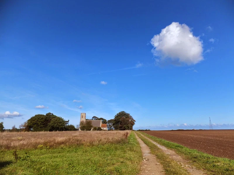
Walking the original route to Norfolk's Paston Way
The Paston Way is a long distance trail around north east Norfolk that takes its names from the eminent Paston family who lived in the area during the 15th century, originating from the village of Paston. Although the route of the trail has been altered in more recent years in order to incorporate additional villages and churches in the area, originally it was a sub-20 mile trail with branches to outlying villages and churches. The original route can still be accessed and is a great way to spend a days walking between Norfolk's North Walsham and Cromer.

Walk Statistics
- Start location: North Walsham
- End location: Cromer
- Distance: miles ( km)
- Total Gain: ft ( metre)
- Total Descent: ft ( metre)
- Min Height: ft ( metre)
- Max Height: ft ( metre)
- Est. Walk Time:
- Walk type: Linear
- Walk Grade: Easy
- Terrain: Footpath, Country Lane

Maps
The following maps and services can assist in navigating this route. There are links to printed maps and links to downloadable GPX route data for importing into navigational software and apps.
- Ordnance Survey Explorer Map
- OS Explorer 252 - Norfolk Coast East
- GPX Route File
Walk Notes
With a mixture of rural villages, open countryside and coastal paths the original Paston Way provides the walker with a complete experience of what North East Norfolk is all about. The are a myriad of historic churches, village pubs, sites of ghostly folk lore and the magnificent coast. You really cant get a better landscape to walk through in this part of the country.
It has to be said that this is one of my favourite Norfolk walks, first undertaken in 2009 and repeated on several occasions since, both in full and also exploring specific sections. The original route was quite straightforward although there were many extensions that could be followed to link in additional churches along the way. The route was updated and extended in the mid-2010s and is now a little longer at 22.5 miles. This amended trail zing-zags across the countryside in an attempt to take in as many of the villages as possible. Even with this update, there are still a few short extensions to get to some of the churches which will add to this distance if fully explored.
I have to admit that in many ways I prefer the original route as it lacks the zig-zagging which gives the impression that one is not getting anywhere, and being under 20 miles makes a great way to spend a full day walking and exploring with time for refreshments along the route. Whereas, to undertake the amended route one really needs to take a couple of days to fully explore the trails sights. There are plenty of walks using the Paston Way that can be found on Griffmonster walks. This particular instance details the original route which is still fully accessible incorporating footpaths, tracks and country lanes. One does need to ignore the new waymarkers, but the resources available on this page are enough to guide any would be walker along the route.
Transport in the area is pretty good, with both train and bus services linking Cromer and North Walsham. There are also bus services that link the coastal towns of Cromer, Overstrand and Mundesley which provide a method of cutting the walk into smaller sections. There really is no excuse for not using these services in order to undertake a walk in the area. They are reliable, have friendly staff and are not costly.
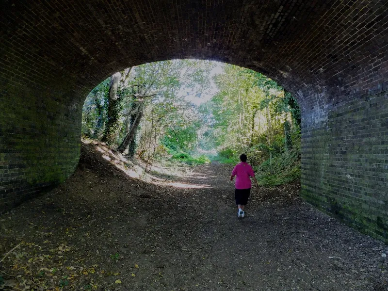
The path starts in the centre of North Walsham and follows the former railway trackbed of the North Walsham to Mundesley railway, originally part of the Norfolk and Suffolk Joint Railway. This section of the railway was opened in 1898 and survived until 1964. The embankments and cuttings are still in place although some of the bridges which are either gone or dangerous involve using the the installed steps on the embankment to get around them. It is a fascinating self contained journey which ends with the Knapton Cutting Butterfly Nature Reserve. This small self-contained designated site is full of flora for attracting butterflies and, according to the Norfolk Wildlife Trust is quoted as supporting a diversity of flowering species such as black knapweed, yarrow, sheep’s sorrel, primrose, oxeye daisy and particularly of note hoary cinquefoil and the small-flowered catchfly, which is classified as Endangered in the United Kingdom.
Beyond the nature reserve the railway used to pass under the Knapton Road but this is all filled as is the cutting beyond, with no evidence in the fields that a railway ever existed. Further along the path of the old line, an embankment rises out of the fields as it passes Knapton village, to disappear again beneath the soils beyond. Knapton station building also survives but is now a private dwelling. This can be seen by taking the updated Paston Way route which navigates into the village. However we shall bypass this and continue on the original route to Edingthorpe.
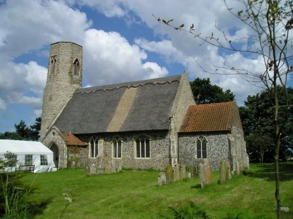
There is not much to Edingthorpe other than its church. According to the University of Nottingham Place name guide, the name derives from a feminine personal name of 'Eadgyth' with the full name from old Norse meaning an outlying farm or settlement. I guess we must conclude the village has always been an isolated farm. Despite this small population, the villages historic thatched church of All Saints should not be missed. Parts of the church are said to date from Saxon times, with the distinctive round tower dating from the 12th century. Take the opportunity to take time out and explore this piece of history. Inside you will be treated to the view of fragments of medieval wall art and similar work adorning the rood screen. These rare artefacts survived all the reformation and puritan purges of religious iconography. Maybe the its isolated location is why it escaped the puritans rampant destruction.
The route then continues to St Andrews Church at Bacton which is a more grand affair that is visible for miles around. Much of this church is a 19th century restoration from the 15th century original but nonetheless worthy of another stop to take it all in.
A path leads from out of the back of the church yard across to the coast at Bacton, where a glorious beach walk takes one up the coast to Mundesley. One should try to time this when the tide is well out to take advantage of the broad sandy beaches. Even at most high tides this is passable although any storm surge or spring tide may force the walker to find an alternative path, either the permissive route along the clifftop (although it is uncertain if this is still open) or the road which is certainly not a good route to walk. Best to plan the hike with tides in mind to make the best choices of when to undertake this walk.
It was this coastal section in 2009 where we encountered a plague of ladybirds. They were everywhere. All the way up the coast and beyond. On any piece of vegetation, there were ladybirds. On the paths, millions of the things crawled in ladybird frenzies. On street signs, ladybirds. On fences hoards of ladybirds. They got in our hair, they hitched rides on our clothes. They attempted to get into my rucksack. Open ones mouth and one would breath in ladybirds. The irony of this particular ladybird episode was that as we dropped down to the beach at Bacton we followed a lady with a large shopping bag on which was emblazoned a large ladybird emblem. Was she the woman who had summoned up the plague or was she just attempting to lure them all into the sea like some pied piperess of Bacton. We have never seen a ladybird plague in these parts since so my bet is on the second option.
The next place up the coast, Mundesley, offers a worthy stop at the Ship Inn where snacks, meals and decent ale can be purchased. This has changed hands over the years but the last few times the Griffmonster Walks crew have visited, we have found a good selection of local Norfolk ales. This is a particularly good place to stop. Although not quite half way, it is a place one can sit, rest, rejuvenate and muse over the sights that have been seen, and, also on the 2009 occasion it provided a haven to get away from the ladybirds as they were clearly not allowed into the pub. Not old enough I presume.
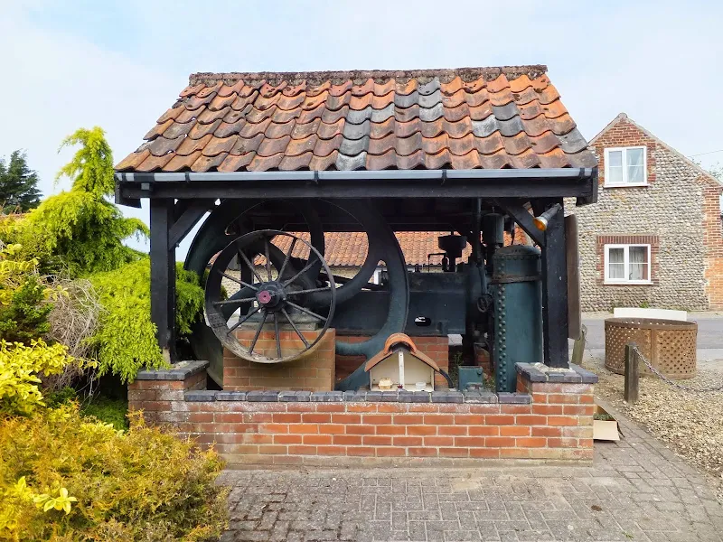
What follows next is a hike across some typical North East Norfolk countryside. The path leads through to the village of Gimingham, where a preserved Crossley diesel engine is housed in a simple open structure by the roadside. This once provided power to an old corn mill that burnt down in 1979. History tells us that a mill stood here going back to at least the time of the Domesday Book. Prior to the installation of the diesel engine, power was generated from a waterwheel which was turned by the flow of water from the mill ponds that one passes as one walks out of the village. These ponds are fed by the River Muns, more commonly known as Mundesley Beck, and for the next few miles the Paston Way leads up and across the river valley. When I say river, it should be emphasized that this watercourse is no more than a gentle stream and the valley no more than a dip in the land but there is still a bridge to cross and a landscape to stand and admire.
The path comes close to the village of South Repps whose church boasts the second tallest tower in the whole of Norfolk. On open days you can pay to climb the tower and from the top you can see miles around, right out to the coast and all the villages in the area. North Repps village is also missed as the path passes the curiously name hamlet of Frogshall to then lead over the hill to Overstrand. In old documents the name is spelt as two distinct words, Frog or Frogs Hall. Quite where this derives from I do not know.
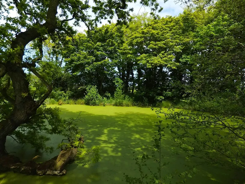
The hill is locally known as Hungry Hill and at its top is a small copse in which sits a water filled pit. It is this pit that is the subject of a cruel and sinister story said to date back to the late 18th century. The tale tells of a young girl named Esmerelda whose affair with a young married farmer from Roughton were discovered by the local Rector who put a stop to it with threats to the man involved. Unable to continue, and in a moment of desperation as she wandered across Hungry Hill, she cast herself into the water filled pit which she then regretted and despite her calls for help, she succumbed to a watery grave. It is said that her haunting cries can still be heard screaming out in the dead of night, specifically on the night of 24th February, the anniversary of when the tragedy was said to have occurred. The pit is known locally as a shrieking pit, a name common with other pits in the area, particularly at Aylmerton where similar folk lore stories are associated with the pits.
The full story is presented on a board afixed to a post by the pool and it is well worth reading although it bears no name as to its author or from where it was taken. The fact that it describes the route to Hungry Hill may indicate that it was intended for the eyes of readers who did not know the area rather than those who strayed upon it whilst passing the pool. It is detailed in its telling with local locations such as Shrublands which it records as being where Esmerelda worked as a maid. Shrublands is indeed a local farm that currently offers a touring site and accommodation in old workers cottages which do date from the 17th century. But can we say that this is a true story or just a local tall tail that ties in specific landmarks for authenticity? It is difficult to say. I have yet to locate the story in any historic publication, but who knows . It has to be said that such stories as this are all part of the rich tapestry of Norfolk and one of the many reasons that we walk these paths to find such hidden gems. Read the full transcript of the sign below.
THE TRASNSCRIPT OF THE LEGEND OF HUNGRY HILL
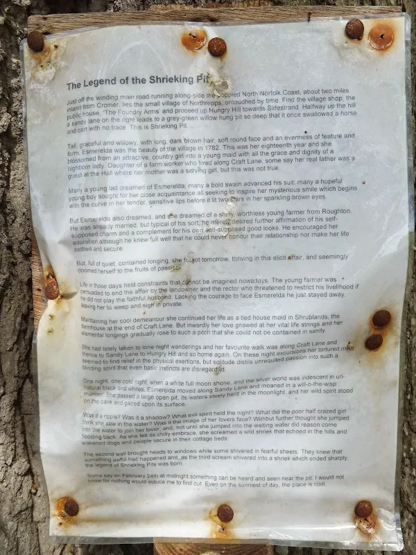
Just off the winding main road running along-side the poppied North Norfolk Coast, about two miles inland from Cromer, lies the small village of Northrepps, untouched by time. Find the village shop, the public house, ‘The Foundry Arms’ and proceed up Hungry Hill towards Sidestrand. Halfway up the hill a sandy lane on the right leads to a grey-green willow hung pit so deep that it once swallowed a horse and cart with no trace. This is Shrieking Pit.
Tall, graceful and willowy, with long, dark brown hair, soft round face and an evenness of feature and form, Esmerelda was the beauty of the village in 1782. This was her eighteenth year and she blossomed from an attractive, country girl into a young maid with all the grace and dignity of a highborn lady. Daughter of a farm worker who lived along Craft Lane, some say her real father was a guest at the Hall where her mother was a serving girl, but this was not true.
Many a young lad dreamed of Esmerelda; many a bold swain advanced his suit; many a hopeful young boy sought for her close acquaintance all seeking to inspire her mysterious smile which begins with the curve in her tender, sensitive lips before it lit two stars in her sparkling brown eyes.
But Esmerelda also dreamed, and she dreamed of a shifty, worthless young farmer from Roughton. He was already married, but typical of his sort, he merely desired further affirmation of his self-supposed charm and a complement for his own self-supposed good looks. He encouraged her adoration although he knew full well that he could never honour their relationship nor make her life settled and secure.
But, full of quiet, contained longing, she forgot tomorrow, thriving in this elicit affair, and seemingly doomed herself to the fruits of passion.
Life in those days held constraints that cannot be imagined nowadays. The young farmer was persuaded to end the affair by the landowner and the rector who threatened to restrict his livelihood if he did not play the faithful husband. Lacking the courage to face Esmerelda he just stayed away, leaving her to weep and sigh in private.
Maintaining her cool demeanour she continued her life as a tied house maid in Shrublands, the farmhouse at the end of Craft Lane. But inwardly her love gnawed at her vital life strings and her elemental longings gradually rose to such a pitch that she could not be contained in sanity.
She had lately taken to lone night wanderings and her favourite walk was along Craft Lane and thence to Sandy Lane to Hungry Hill and so home again. On these night excursions her tortured mind seemed to find relief in the physical exertions, but solitude distils unrequited passion into such a blinding spirit that even basic instincts are disregarded.
One night, one cold night, when a white full moon shone, and the silver world was iridescent in un-natural black and whites, Esmerelda moved along Sandy Lane and moaned in a will-o-the-wisp manner. She passed a large open pit, its waters steely hard in the moonlight, and her wild spirit stood on the bank and gazed upon its surface.
Was it a ripple? Was it a shadow? What evil spirit held the night? What did the poor half crazed girl think she saw in the water? Was it the image of her lovers face? Without further thought she jumped into the water to join her lover; and, not until she jumped into the waiting water did reason come flooding back. As she felt its chilly embrace, she screamed a wild shriek that echoed in the hills and wakened dogs and people secure in their cottage beds.
The second wail brought heads to windows while some shivered in fearful sheets. They knew that something awful had happened and, as the third scream shivered into a shriek which ended sharply, the legend of Shrieking Pits was born.
Some say on February 24th at midnight something can be heard and seen near the pit; I would not know for nothing would induce me to find out. Even on the sunniest of day, the place is cool.
The final part of the walk leads into Overstrand and down to the coast where another sandy beach walk provides the final stage to Cromer. Despite this beautiful scenery it is guaranteed that one will be talking about the story of Esmerelda as one paces to ones final destination of Cromer. And those tales will still be ringing in ones head as they are cogitated over a pint in the Red Lion Hotel.
Route Validation Cards
Validation Date - 17/07/2010
- Time of Walk: 08:30 to 18:00
- Validators: griff, kat
- Weather Conditions: warm sunny summers day
- Notes: Initial route undertaken
Summary of Document Changes
Last Updated: 2026-04-20
- 2010-06-25 : Initial Publication - now archived
- 2021-03-17 : Update website improvements and removal of ViewRanger reliance
- 2021-05-01 : Rewrite and update to be consistent with the rest of the site formatting
- 2021-12-01 : Removal of ViewRanger links due to its imminent demise
- 2026-01-12 : Major website update with all walks recast to the new format


0 comments:
Post a Comment