South West Coast Path - Swanage to South Haven Point
Monday, 26 April 2021
|
No comments
|
![]()
An moderately easy walk to the end of the South West Coast Path at South Haven Point
Old Harry Rocks is the highlight of this walk, and the ascent to Handfast Point, off of which the rocks are located, is the only real effort that has to be expended during the duration of this walk.The rest of the walk is easy all the way through to the end of the South West Coast Path at South Haven Point.

Walk Statistics
- Start location: Swanage
- End location: South Haven Point
- Distance: miles ( km)
- Total Gain: ft ( metre)
- Total Descent: ft ( metre)
- Min Height: ft ( metre)
- Max Height: ft ( metre)
- Est. Walk Time:
- Walk type: Linear
- Walk Grade: Medium
- Terrain: Footpath

Maps
The following maps and services can assist in navigating this route. There are links to printed maps and links to downloadable GPX route data for importing into navigational software and apps.
- Ordnance Survey Explorer Map
- OS Explorer OL15 - Purbeck and South Dorset
- GPX Route File
Walk Notes
This was the ninth stage of 10 days walk along the Jurassic Coast section of the South West Coast Footpath between Exmouth and Poole, or more specifically South Haven Point which is the official start or end of the South West Coast Path, depending on the direction that one is walking. This particular 10 day expedition was just a taster for the South West Coast Path and it has to be said that it did not disappoint. It is arduous in places, but the views are magnificent and this final section is easy compared to the rest of this Jurassic Coast section.
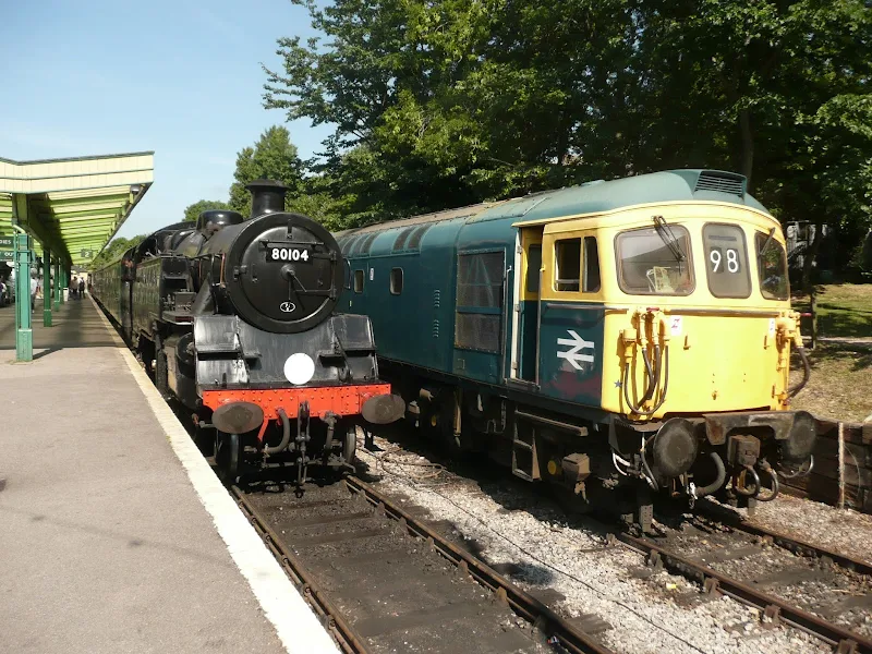
For this section we had located a base camp at Toms Field at Langton Matravers. From the site there was a short walk to the bus stop to transport us through to the start of the days walking, Swanage train station. This is the home of the Swanage Railway, a heritage line that has its roots way back in 1972 when British Rail withdrew the passenger services. The line has now been reinstated along the 11 miles between Swanage and Wareham where it connects to the mainline. Regular steam and diesel services operate on a daily basis throughout the year. With such an attraction it is worth taking some time out to view the rolling stock in the station.
There is a short walk to the sea front to join the South West Coast Path which follows Swanage Bay alongside the main seafront road. The road bears away from the sea front to the north of the town, and the trail follows this as there is no access from the beach up to the cliffs beyond. The route eventually leads through a housing estate to emerge on the clifftop path which slowly climbs to the foot of Studland Hill. Then follows the only real challenge of the day where the path ascends some 50m to lead out to Ballard Point.
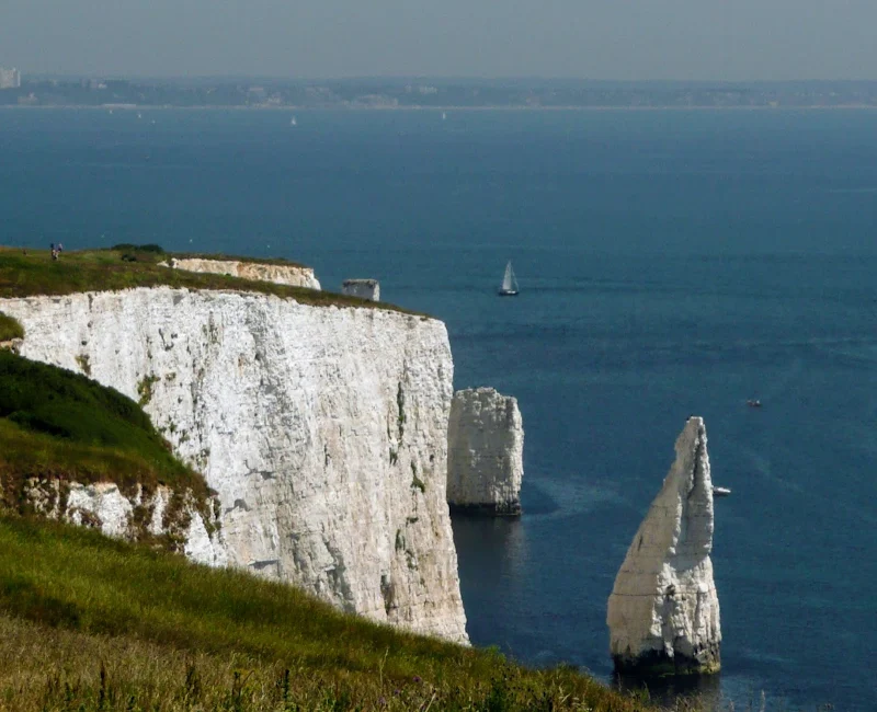
Then it is easy walking all the way through to Handfast Point off of which are three chalk formations divorced from the headland, their white faces standing out brilliantly against the blue of the sea and sky, and their tops tufted with grass. These are known as Old Harry's Rocks formed from centuries of erosion of the Point, first forming arches and then resulting in disconnected stacks of chalk when the arches collapsed. The three formations are known individually as Old Harry, Old Harry's wife and No Man's Land and are a sight to behold. A path leads through to the very tip of the point for those who do not suffer from vertigo and want a closer view, but better full views can be had from the distance.
There appears to be no specific agreement as to where the name of Old Harry's Rocks was derived from. Some say it was taken from the name of the devil himself, Old Harry being a facetious name for the devil that originates in the mid 1700s. The legend states that Old Harry slept upon the rocks and consequently the formation was given his name. Such demonic legends persist for many rock formations around the South West Coast Path, one could almost believe the area was the holiday haunt of the devil.
Another explanation goes back to the 9th century when legend tells us that a Viking raid was defeated by a storm resulting in the drowning of Earl Harold who was turned into a pillar of chalk. The are in the 9th century was rampant with Viking incursions and the Saxon chronicles does record an entry for the year 871 AD where King Ethered and his brother Alfred (the renowned King of British history and who burnt the cakes) defeated the Danes, and this passage includes the line King Æthelred faced the [Viking force] led by the heathen kings, Bagsecg and Halfdan, and Bagsecg was slain, and Alfred faced the one led by the earls, several of whom (Sidroc the Old, Sidroc the Younger, Osbearn, Fræna and Harold) were slain
. Although this battle occurred in Wessex, it was said to have taken place at Ashdown. So maybe it was a different Harold, or just good old fashioned folk-lore that has been tailored to fit the geography.
A more down to earth explanation is that the rock formations were named after a renowned pirate by the name of Harry Paye. Paye, aka Page, operated in the late 14th and early 15th centuries and was said to use the rocks to lay in wait for French and Spanish ships, which he would then attack and bring their booty back home to the folk of Poole, his home town. He was seen as a sort of Robin Hood of the seas, once bringing home 12,000 gallons of the finest French wine in a revenge attack on a French ship for their part in a raid on the town. It was said that the whole population of Poole was drunk for a month after he landed the booty. The locals still celebrate Harry Paye Day on 15th of June each year where are glass is raised to this favourite son of Poole. This tale certainly appears to be rooted in a more factual piece of history.
Before we leave musing over the legends of old Harry, there is one final tale that tells of the ghostly bells that can be heard ringing from beneath the sea during stormy nights. This is said to emanate from a ship that had been transporting the bells to be hung in Poole church. It is said that the sailors aboard that ship were so profane in their language for such a sacred cargo that the blasphemous behaviour resulted in a storm whipping up and wrecking the ship on the rocks, taking down the ship, the crew, the bells and all. The story comes from a 1906 publication named Strange Adventures in the County of Dorset by E.J. Climenson and may well be a mixture of fact and embroidered legend.
With all this absorbing scene and legend taken in we are ready to take the pleasant stroll down to the village of Studland where The Bankes Arms pub offers a welcome refreshment stop where a wide range of food can be accompanied by an excellent selection of guest ales together with a full range of ales from the Isle of Purbeck Brewery. A very rewarding place for ones efforts over the headland.
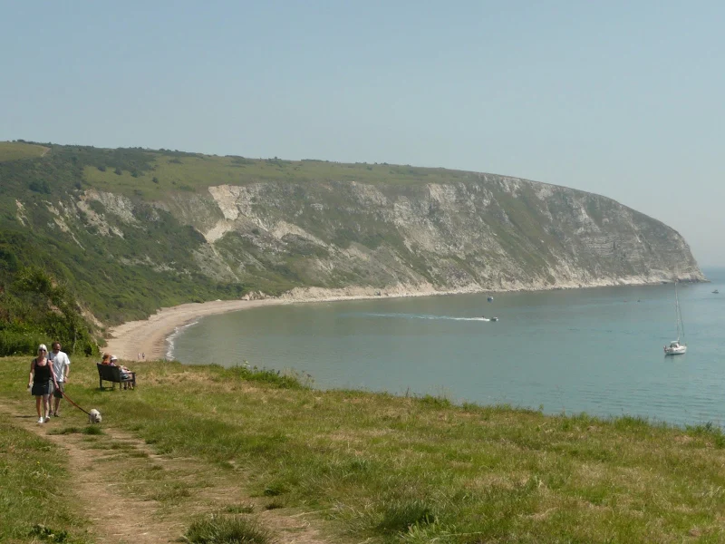
The end section of this walk from Studland to the South Haven Point is along the beach that fronts Studland Bay. This is a glorious sandy beach. Soft sand does take some effort to plod through but with the end in sight then there is no rush to complete ones journey. Do beware that this beach section includes a naturist area which, certainly on the occasion we walked it, was very busy with those folk so inclined to dispose of their every day wares and are completely ambivalent to passing strangers. It has to be said that for us mortals who are not used to wandering through a sea of naked bodies it is most dis-concerting as wherever one places ones eyes there are unaccustomed views. Folk going about their business, sunbathing, swimming, paddling, in casual conversation, all naked. And the line fishermen. Yes line fishing on a naturist beach with nothing but a rod in hand and tackle at their feet and stark b*ll*ck naked bodies. I would say no pun intended, but who cannot think of such puns and innuendos when one is not used to wandering through such areas. It is an eye-opening experience.
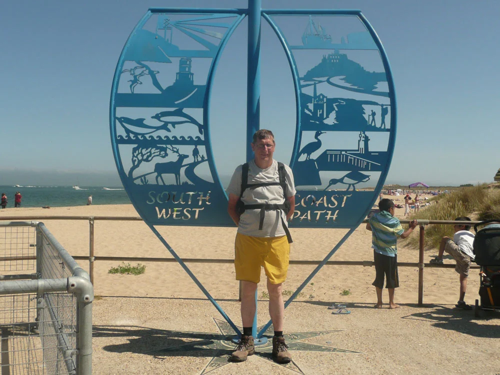
These sights certainly provoked laughter and conversation as we headed to the very end of the South West Coast Path. The end point is marked with a sculptured metal sail that has depictions of features around the whole trail. One has to stand and have ones photo taken in front of this. Whether one is starting the path, end the the trail or merely ending the Jurrasic Coast section, it provides the reminder and expectations of this truly great trail.
It as to be said that we did take the ferry across to Sandbanks, just to say we had done it. And there lies another trail to pick up, The Bournemouth Coast Path. Another challenge for another day.
Route Validation Cards
Validation Date - 26/06/2010
- Time of Walk: 10:30 to 17:30
- Validators: griff, kat
- Weather Conditions: very warm, blue skies
- Notes: Initial route undertaken
Summary of Document Changes
Last Updated: 2026-04-20
- 2010-06-25 : Initial Publication
- 2021-03-17 : Update website improvements and removal of ViewRanger reliance
- 2021-04-11 : Rewrite and update to be consistent with the rest of the site formatting
- 2021-12-01 : Removal of ViewRanger links due to its imminent demise
- 2026-01-12 : Major website update with all walks recast to the new format


0 comments:
Post a Comment