Route details, maps, pubs, features, local history and folklore for a wide variety of walks focusing primarily on Norfolk and Suffolk

Walks
Showing posts sorted by date for query Falmouth. Sort by relevance Show all posts

Sunday 16 December 2018

South West Coast Path - Sennen Cove to Pendeen

Cliff mines at Botallack

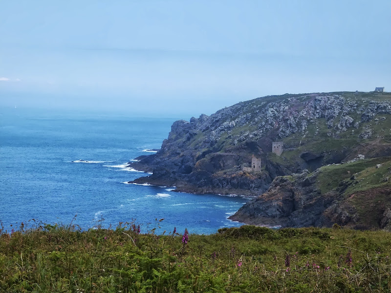
A rewarding 9 mile walk along the South West Coast Path between Sennen Cove and Pendeen

This is a spectacular section of the South West Coast Path following the rugged cliffs on the western edge of Cornwall. There are a few challenges with the craggy terrain through to Cape Cornwall but the scenery is well worth the effort. The last stage is littered with the remnants of old mine workings that nestle into the cliff sides. These crumbling deserted edifices to old industry now sit aesthetically with their surroundings and at one with nature.

Wednesday 12 December 2018

South West Coast Path - Starcross to Paignton

Dawlish Sea Wall Railway

A lengthy section along the South West Coast Path taking in the the English Riviera between Starcross and Paignton

From the Exe estuary where the ferry links Exmouth and Starcross, the South West Coast Path heads southwards through the English Riviera Towns of Dawlish, Teignmouth, Torquay and Paignton. This section is a mixture of level walking through towns interspersed with hill walking through Maidencombe, Watcombe and Babbacombe and out to Hope's Nose. There are excellent transport links throughout including the iconic railway that runs along the sea wall from Teignmouth up to Starcross and is as inspiring as the walk itself.

Tuesday 20 November 2018

South West Coast Path - Yealm Estuary to Avon Estuary

Erme Estuary

A 19.5 mile walk along the South West Coast Path between the Yealm and Estuaries, using additional footpaths to access transport to link each end of the walk.

There are ferries across both the Avon and the Yealm estuaries but this route takes a trail that enables navigation around them using footpaths and lanes. Even so, there is still the Erme estuary to negotiate midway along the coast. There is no ferry here but it can be waded across one hour either side of low tide. This is quite an experience but requires planning with reference to the tide times published for Devonport. There are few other features apart from the stunning scenery along this section of the coast walk until it gets to Bigbury on Sea where Burgh Island sits just off the coast and hosts the renowned Pilchard Inn. The island can be reached on foot at low tide and at other times the inn makes use of a sea tractor to drive visitors across.

Walk Summaries

Latest walk summaries are basic information sheets for walks that have yet to be fully documented. These provide links to maps, public transport and walks stats, although detailed notes and features are not included.

Latest Walk Summaries

Featured Walk

In Search of Sizewell Chapel

A 10 mile walk following the southern side of the parish boundary of Leiston in Suffolk This walk follows the route of a 17th century peramb...

What is GPX

All you need to know about GPX, electronic mapping and how to use modern apps and mobile devices as navigation devices

Popular Walks

Maps