Wales Coast Path - Abergele to Prestatyn
Tuesday, 9 July 2019
|
No comments
|
![]()
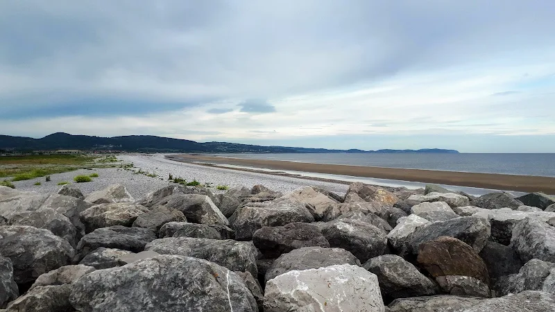
An unashamed 10 mile British seaside walk along the North Wales coastline
An unashamed easy walk along the proms and seawalls of North Wales between Pensarn and Prestatyn. This walk is never far from civilisation and one can guarantee meeting numerous folk along the trail. Dog walkers, joggers, tourists and folk just enjoying the sea air. The route doubles up as a North Wales Cycleway (National Cycle Route 5) which is well used throughout.

Walk Statistics
- Start location: Abergele
- End location: Prestatyn
- Distance: miles ( km)
- Total Gain: ft ( metre)
- Total Descent: ft ( metre)
- Min Height: ft ( metre)
- Max Height: ft ( metre)
- Est. Walk Time:
- Walk type: Linear
- Walk Grade: moderate
- Terrain: Prom walk virtually all the way.
- Obstacles: It should be stressed that the broad sandy beaches are prone to cut off from tides with quicksand hazards. It is therefore wise to stick to the promenade

Maps
The following maps and services can assist in navigating this route. There are links to printed maps and links to downloadable GPX route data for importing into navigational software and apps.
- Ordnance Survey Explorer Map
- OS Explorer 264 - Vale of Clwyd
- GPX Route File
Accommodation
Manorafon Farm Campsite, AbergeleView in OS Map | View in Google Map
- Website
- https://www.manorafon-farm-park.co.uk/stay/facilities/
- Description
- Compact and popular family campsite with easy access to town and public transport
Transport
Traveline - Bus Service
- Service Details
- 131 - At the time of walking this route the 131 Arriva bus service provided a link between Prestatyn, Abegele, Llandudno Junction and Llandudno. It is advised to use the Traveline website to obtain the latest schedules and operators
- Timetable
- Traveline
Walk Notes
This was the first walk undertaken on the Wales Coast Path and an easy introduction to this extensive trail around the Welsh coastline. It has to be admitted that this North Wales section is dominated by holiday parks and tourist attractions. However, the prom path is somewhat shielded from the ever expanding fields of chalets and caravans and the views along the coast and across the vast sandy beaches are captivating throughout. The promenade is a relatively busy walkway with plenty of people taking in the sea air from the various holiday parks. It has to be said that the accompanying cycleway may be a little disconcerting but it was found that all the cyclists were considerate giving plenty warning of their approach and cycling in a sedate manner rather than an urgent pace that one finds on more urban routes.
The start of the walk is Abergele as this is where the local bus service links the two ends of the walk. Abergele is derived from the Welsh words aber
, with the meaning of estuary and gele
which is the name of the river which flows through the town. Therefore quite simply this is the town of the Gele estuary.
An alternative to link the ends of this linear walk is to use the train from Pensarn which is the coastal front to Abegele whose name translates as end of the causeway
. The seafront is directly adjacent to the station and there is easy walking past Towyn and Kimmel Bay in order to reach Rhyl.
Rhyl presents a mid point where there is the opportunity for refreshments at the Harbour Hub cafe. This location also provides toilet facilities adjacent to the cafe. This is pretty much a relief as there are no trees to hide behind on this walk and the vast open beaches are never free of people. Even if there was no-one around then the sound of one having a quick piddle would echo all around the North Wales coast and bring in sightseers from miles around to witness the toilet habits of a lesser spotted Griffmonster.

Opposite the cafe is the Pont y Ddraig suspension bridge whose name translates as Dragon's Bridge, the name chosen by local schoolchildren. This bridge with a single 45 m high central mast, provides access across the harbour for both cyclists and walkers. It is an impressive sight to behold and is a good photographic opportunity with the myriad of sailing craft that are moored up the estuary of the River Clwyd.
Rhyl once boasted a pier which opened in 1867 and lasted nearly 100 years before it was declared unsafe in 1966, eventually being demolished in 1973. Nothing remains of the pier these days and the majority of passers by are probably completely unaware of its previous existence as they pass by the sea aquarium building, the location from where it extended some 2355 feet out across the beach.
The walk ends at Prestatyn. It is very easy to just keep on walking without noticing one has passed the principle route into town. The seafront continues on to the Gronant Dunes Nature Reserve and the Coast Path leads around this to meet the River Dee estuary. There was a consideration of purposely extending this walk to include a circular route around the nature reserve, something that a procession of runners in the RunFest Wales event were also seemingly doing. However a last minute change of plan changed our strategy. Offas Dyke! Yes, Offas Dyke, the renowned National Trail that marks the border of England and Wales. Prestatyn is the start or end of this 182 mile trail depending upon the direction one travels and this end is marked on the sea front by a tall shiny steel sculpture on which three twisted legs hold aloft a circular rim with a hole at its centre, locally earning it a nickname of the Polo Mint. It is unclear exactly what this 20 foot structure is supposed to represent but it certainly makes a point and provides a suitable marker as to where one needs to head into town and a waymarker points down the road with an indication that Chepstow is a mere 182 miles away. Now for any keen hiker who has not undertaken Offas Dyke, there must be a yearning to grasp this iconic route and that was just what caused a change of plan. A walk away from the Coast Path to sample a little experience of Offas Dyke. Not much, just a short circulaar walk, but enough to provide an essence of what it is all about. But that is another walk. That is another story appearing on this site.
The town of Prestatyn provides a host of facilities with plenty of restaurants, cafes and pubs. There is also ample public transport back to the start of the walk with the bus terminus outside the Aldi supermarket where the 131 service returns back to Abergele. The train station which is closer to the seafront offers rides back to Pensarn.
Route Validation Cards
Validation Date - 2019-06-23
- Time of Walk: 07:30 to 12:00
- Validators: Griffmonster, Kat
- Weather Conditions: Warm but somewhat overcast
- Notes: Initial route undertaken
Summary of Document Changes
Last Updated: 2026-05-16
- 2019-07-09 : intial publication of summary
- 2021-03-17 : Update website improvements and removal of ViewRanger reliance
- 2021-12-01 : Removal of ViewRanger links due to its imminent demise
- 2026-01-12 : Major website update with all walks recast to the new format


0 comments:
Post a Comment