East Runton to Aldborough Circular Walk
Sunday, 12 December 2021
|
No comments
|
![]()
A 17 mile circular walk through the countryside of North Norfolk linking East Runton and Aldborough
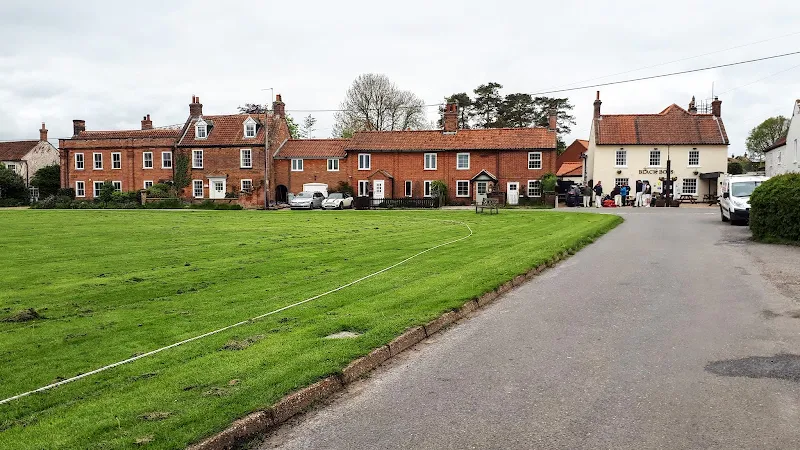
Aldborough is the quintessential English village with a pub facing the large village green where the sound of willow on leather can be heard from the afternoon games of cricket that are frequently staged during lazy summer afternoons. You cannot get a more stereotypically English village than Aldborough.

Walk Statistics
- Start location: East Runton
- Distance: miles ( km)
- Total Gain: ft ( metre)
- Total Descent: ft ( metre)
- Min Height: ft ( metre)
- Max Height: ft ( metre)
- Est. Walk Time:
- Walk type: Circular
- Walk Grade: Medium
- Terrain: Footpath, Country Lane, Track
- Obstacles: It should be stressed that the broad sandy beaches are prone to cut off from tides with quicksand hazards. It is therefore wise to stick to the promenade

Maps
The following maps and services can assist in navigating this route. There are links to printed maps and links to downloadable GPX route data for importing into navigational software and apps.
- Ordnance Survey Explorer Map
- OS Explorer 252 - Norfolk Coast East
- GPX Route File
Accommodation
Woodhill Park CampsiteView in OS Map | View in Google Map
- Website
- https://www.woodhill-park.com/
- Description
- Located on the clifftops at East Runton, half way between Sheringham and Cromer, this highly recommended touring site is ideal for exploring North Norfolk with public transport available to many destinations from the entrance to the site.
Walk Notes
This walk was intended to an find alternative route, both outward and return, to the Weavers Way route that links Cromer and Aldborough. This proved a successful navigation and provides a delightful way to pass a full days walking around the North Norfolk countryside. There are a couple of section where the Weavers Way is made use of but the rest is an exploration of the small villages and country lanes that predominate around this part of Norfolk. There are churches to visit and history to soak up and landscape features to provoke thought and later research.
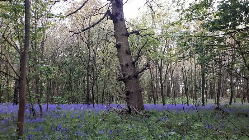
This walk is approximately 17 miles so does require a full day if one wants to take ones time. The occasion we undertook this was in late may and there was ample woodland that bloomed with a bright blue covering across the floor from a host of vibrant bluebells. Despite recent rains the walk for the most part was firly dry although one ploughed field presented a muddy challenge to overcome, but that is all part of the joy of walking and exploring.
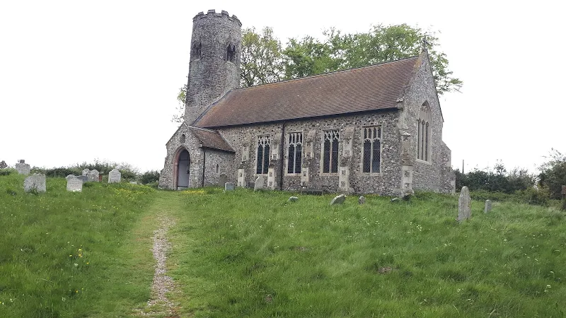
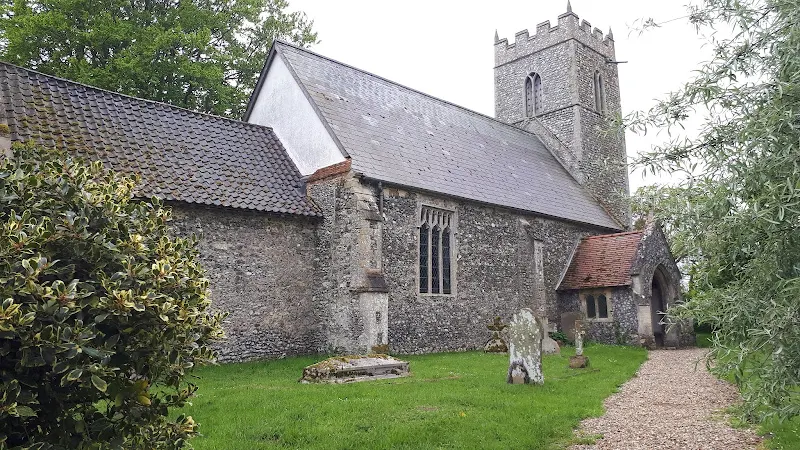
Norfolk never fails to impress with its numerous churches. The first one encountered along this route is at Bessingham where the round towered church of St Marys stands. The church stands divorced of the village and is where the footpath that links the villages of Gresham and Bessingham. This footpath emerges onto the road adjacent to the church.
The church is worth taking time out to admire. The tower dates from some time around the conquest of 1066 and is said to be the result of two separate independent builds. Whether this build was a mix of Saxon and Norman is unknown. The chancel and nave are the result of Victorian renovation of the original 15th century construction but the door is said to be even older, dating from around 1300. For those who now suspect that a door in a field next to a tower was the reason for the construction of a building to contain the door, then I feel you are being misled and there must have been an older construction that predated the 15th century build. It is interesting to note that the medieval rood screen that once stood between chancel and nave was relocated to Baconsthorpe church where it can still be seen.
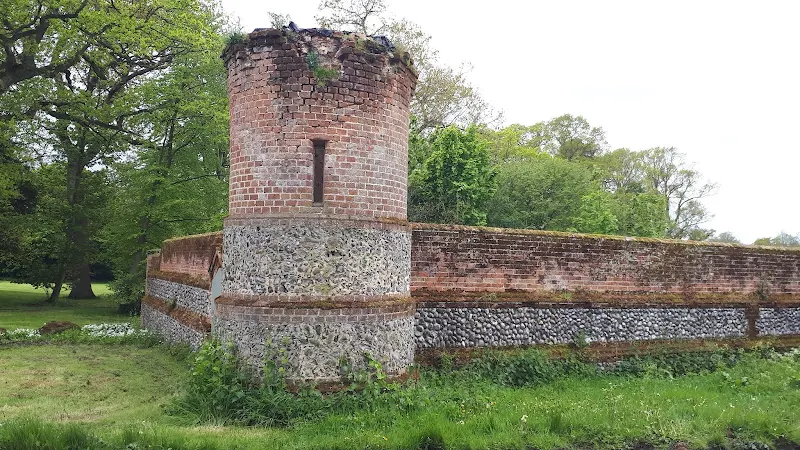
As we leave Bessingham we pass by the walls that surround Bessingham Manor where a round tower stands guard where the wall turns away from the road. Although one may suspect this has some history it is no more than a Victorian folly. The red bricked walls of both this perimeter wall and the manor house were built in 1870, with the house being constructed in a Jacobean style. The three storey house has a vaulted cellar and many outbuildings include stables and is currently available as rented accommodation aimed at the holiday trade or for large celebrations.
Country lanes connect Bessingham and Aldborough which makes for easy walking. As one wanders into the heart of this unassuming village one is greeted with a scene that can only be described as quintessentially English. There is an extensive village green surrounded by houses and overseen by the remaining village pub. On summer weekends games of village cricket unfold on the green and crickets and spectators alike imbibe with the beers and ales from the pub to while away an afternoon in typical olde English fashion. What a better way to spend an afternoon. In the words of the late great Vivian Stanshall, As English as tuppence, changing yet changeless as canal water, nestling in green nowhere
.
As we arrived at the pub cricketers assembled at the Black Boys pub and the green was being prepared for an afternoon match. The beer was being imbibed and musings of the days outcomes being discussed. No doubt a perfect afternoon would be had with the distinctive sound of leather on willow softly easing itself between song of the birds and the breezes rustling the trees.
We arrived at the pub for refreshments. Although the selection of ale is small it is local Norfolk ale and a pleasure to drink. On this particular occasion it was Mr Winters brewery, a rebrand of the former Winters where they have not only rebranded but expanded their range of ales. The Atom Smash ale on offer here was a fine pale ale that certainly hit the spot and provided the perfect compliment to the crusty prawn baguette.
Having spent a good hour at the pub it was time to leave behind this village, to forsake an afternoon of cricket and get back to finding our way back to the coast. The route we had planned follows the Weavers way through to the village of Hanworth which is always a pleasing place to walk through with its ancient common and gated lanes. It is like stepping back in time as nothing seems to have changed here for centuries.
As we leave Hanworth, we diverge from the the Weavers Way to head northwards to the village of Metton. The unusual square tower of Metton's St Andrews church can be seen from some way off along the track linking Hanworth and Metton. Indeed, this track bears the name of Chruch Lane and emerges into the village adjacent to the church.
The building dates from the 1300s and there is evidence to suggest that it once held a central tower. The present structure is primarily the result of Victorian renovations although the interior still bears 15th century brasses and evidence of a medieval roof.
The final section of the walk leads along a track through the grounds of Felbrigg Hall to rejoin the Weavers Way back down into Cromer. This is a walk down the hills to the coast and Cromer does not become visible until one walks into the town, is existence hidden by the woodland around Cromer Hall.
Route Validation Cards
Validation Date - 22/05/2021
- Time of Walk: 09:00 to 16:30
- Validators: griff, kat, helen a
- Weather Conditions: overcast
- Notes: Initial route undertaken
Summary of Document Changes
Last Updated: 2026-04-20
- 2021-12-12 : initial publication of summary
- 2026-01-12 : Major website update with all walks recast to the new format


0 comments:
Post a Comment