Route details, maps, pubs, features, local history and folklore for a wide variety of walks focusing primarily on Norfolk and Suffolk

Walks
Showing posts sorted by relevance for query Maldon. Sort by date Show all posts

Tuesday, 22 February 2022

The Essex Coast - Tollesbury to Maldon

The seventh and last stage of a weeks walking along the Essex Coast between Manningtree and Maldon.

Due to the limited buses between Tollesbury and Maldon we took the decision to walk this in reverse as we did not want to miss the last bus back to Tollesbury from Maldon at 4:30. Doing this would then give us more time to take in the sights along the Blackwater estuary. Although this was the last section on this occasion we returned a few years later to continue from Maldon and onto Purfleet.

Wednesday, 22 August 2018

Essex Coast - Maldon to St Lawrence Walk Summary

Salt marsh

A walk along the southern side of the Blackwater estuary from Maldon to St Lawrence

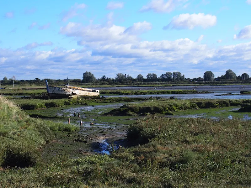
This 16 miles walk provides great views of the Blackwater estuary with vast open panoramas of the tidal river. Mudflats and gulleys provide havens for wildlife and there are numerous old dilapidate river craft that sit decaying into the mud, forgotten and forlorn.

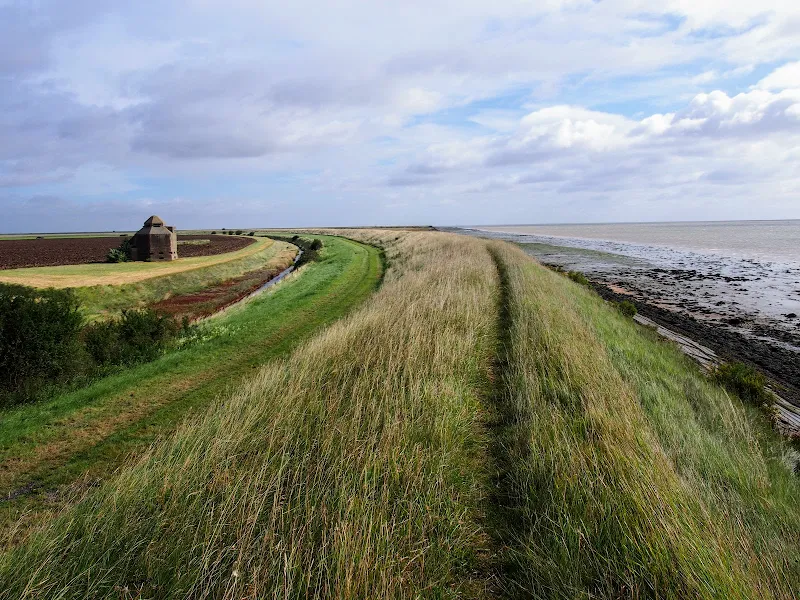
The path navigates around the numerous creaks and inlets that abound this southern side of the estuary. The path uses the compacted river defence banks which makes it hard on ones feet and offers no shelter from the elements. Given a brisk breeze and light showers, it can take its toll on ones enthusiasm as the path winds in and out of the creaks through to Maylandsea, at times seemingly navigating in the wroing direction.

This specific route does offer a shortcut out of Maylandsea by following the St Peters Way path. This links Lawling Creek and Mayland Creek and provides a short but welcome change of scenery.

The route ends at the Waterside Park in St Lawrence. This provided touring accommodation for those wanting to explore this coastline. Having said this, the park was taken over in December 2017 and it is uncertain whether touring sites are still available. Recent Trip Advisor reports are not encouraging.

Note that public transport in this area is very limited and most major roads can be choked with traffic especially at rush hour. There is a limited bus service between St Lawrence and Maldon.

Few of the pubs and bars offer any real ale and it was a unexpected discovery to find that the modern Blackwater Bar provided a very good example of St Austells Proper Job ale. Admittedly this is far from its Cornish homeland but in the ale desert of this part of Essex it was a just reward for days walking.

Tuesday, 22 February 2022

The Essex Coast - Salcott to Tollesbury

The sixth stage of a weeks walking along the Essex Coast between Manningtree and Maldon.

Tollesbury was not an easy location to get to using public transport, therefore we drove down to the village and made two circular walks in a figure of 8, firstly up to Salcott and back, then around Tollesbury Wick marshes. Here we at last saw the sea, the first glimpse since Brightlingsea, with Mersea Island just across the estuary.

The Essex Coast - Tollesbury Marshes Walk

A walk around the Tollesbury Marshes

A rewarding short walk around the Tollesbury Wick marshes.

Tuesday, 21 September 2010

The Essex Coast - Manningtree to Maldon


The Essex Coastline is arguably the longest of any British county when you take into account all the estuaries that need to be navigated. The total distance can be in excess of 300 miles and encompasses seaside towns, wild and remote marshes and pleasant country paths. There is currently no official footpath around the Essex Coast although there is currently negotiation taking place for the instating of the England Coast Path through the county. This guide provides a coastal route that can presently be used. With the assistance of Peter Catons book 'Essex Coast Walk' and the appropriate OS maps, one can make up a route of ones choice and this is a fine way to explore this part of the British coastline. Our path started along the Essex Way and then used recognised public footpaths and sea defences where possible. When all else failed we had to resort to road, but thankfully there was not too much road walking.

Sunday, 26 August 2018

Essex Coast - Burnham-on-Crouch to Bradwell Walk Summary

Salt marsh

A 15 mile walk along the remote Essex coast from Burnham-on-Crouch to Bradwell

Many publications have stated that the section of the Dengie peninsular that borders the sea, east of the town of Burnham-on-Crouch, is the most remote place in the entirety of England. It is true that this isolated area of Essex is far from any major centres of population but walking this coast path one is never completely devoid of the signs of civilisation. Although one may never meet another soul on this lonely path, there are farms and machinery working the fields, haystacks and narrow lanes heading inland. All evidence that civilisation is not far away and, indeed, the nearest town is never more than 5 miles away as the crow flies.

The route is predominantly defence banks with a panorama of flat marsh to one side and acres of flat farmland on the other leaving with just the defence bank the tallest structure around. This leaves one distinctly exposed to the elements and faced with wind and rain it can require additional effort to push onwards. There are wide areas of cut grass on the landward side of the banks which can be utilized as a sheltered walking refuge when the going becomes a struggle or when the top of the bank is overgrown as found it some sections in this instance.

It has to be said that the constant unchanging scenery of this flat landscape can become somewhat monotonous as the miles slowly slip away. The smallest of landmarks then become a haven for curiosity. A sluice gate. A WWII pill box. Discarded tyres and debris in the marsh mud. The skeletal remains of a ship rotting on the marsh. A metal 5 bar gate with numerous plastic pieces of jetsom and flotsam seemingly purposely tied to it cluttering the mind with wonder as to its intentions.

The final part of the walk leaves the coast to navigate up the lanes to the village of Bradwell. There is a bus service from here although buses are few and far between. The D4 service returns to Burnham-on-Crouch. The alternative, as in this instance where accommodation was at St Lawrence is the D1 Service which links Bradwell, St Lawrence and the village of Latchingdon where the regular 31 service proceeds to Burnham-on-Crouch.

Monday, 21 February 2022

The Essex Coast - Walton-on-the-Naze to St Osyth

The third stage of a weeks walking along the Essex Coast between Manningtree and Maldon

A promenade walk that runs most of the way from Walton through to Jaywick that makes an easy and pleasant afternoons stroll. This was undertaken on the Saturday afternoon with crowds of day visitors making the most of the sea, sun and sand before Autumn ushered in .

Tuesday, 20 March 2018

Eye to Hoxne Circular Walk

Hoxne village

A 10 mile walk around the Suffolk villages of Eye and Hoxne

Hoxne is said to be where St Edmund was Martyred by the Viking invaders in the 9th century. The village is full of reminders of the gruesome event including the cross which marks the place of the oak tree his assailants tied him to, beat him, fired arrows at and eventually beheaded and the bridge he reputedly hid trying to escape his captors.

Friday, 1 August 2025

Essex Coast Walk - Manningtree to Great Oakley

Overlooking the Stour estuary

A day walk along the Essex Way

A fine piece of walking along the Essex Way to provide some glorious views of the Stour estuary before turning inland to avoid Harwich and Dovercourt. Estuary views, marsh, woodland and open fields make for a varied scene throughout the walk.

Tuesday, 22 February 2022

The Essex Coast - Wivenhoe to Salcott

The fifth stage of a weeks walking along the Essex Coast between Manningtree and Maldon.

This stage of the walk touched the outskirts of Colchester at Hythe where the first bridge across the river Colne is found. Then it was a case of following the river back down to Rowhedge. This part involved a lot of road walking as there is a military range along the banks of the Colne and the next time we would see the coast would not be until Tollesbury.

Sunday, 13 January 2019

Great Dunmow Town Trail

The Doctors Pond

A 3 mile circular walk around the small Essex town of Great Dunmow

With plenty of historic buildings, a fine 13th century church, some great pubs and a fantastic Indian Restaurant this provides any visitor a taste of this ancient town. The walk is simple and easy and one cannot visit Dunmow without discovering the interesting history of the Dunmow Fitch which is the main feature to this walk.

Monday, 13 September 2010

The Essex Coast - Manningtree to Great Oakley

Overlooking the Stour estuary

A day walk along the Essex Way

A fine piece of walking along the Essex Way to provide some glorious views of the Stour estuary before turning inland to avoid Harwich and Dovercourt. Estuary views, marsh, woodland and open fields make for a varied scene throughout the walk.

Monday, 21 February 2022

The Essex Coast - St Osyth to Wivenhoe

St Osyth to Wivenhoe

The fourth stage of a weeks walking along the Essex Coast between Manningtree and Maldon.

All weekend the weather forecasters were issuing weather warnings of torrential rain for the Tuesday that we were due to walk this section. As it happened, the rain came down in the night and the walk up the Colne Estuary turned out to be a sunny day and a well worth walk. Even though this was the longest section that entailed some road walking and a couple of errors in navigating it was probably the most rewarding of the weeks walks.

NOTE

This is a walk summary intended to provide the user with just the essential information in order to navigate the walk route. Fully detailed information notes, refreshment stops and walk features are not included in this. A full write up will be included in the near future.

St Osyth to Wivenhoe - Essential Information

Walk Statistics (calculated from GPX):

  • Start location: St Osyth 
  • End location: Wivenhoe 
  • Distance:   miles (  km)
  • Total Gain:   ft (  metre)
  • Total Descent:   ft (  metre)
  • Min Height:   ft (  metre)
  • Max Height:   ft (  metre)
  • Walk Time:  
  • Walk Grade: Easy
  • Terrain: Footpath, Road

Maps:

The following maps and services can assist in navigating this route. There are links to printed maps and links to downloadable GPX route data for importing into navigational software and apps.


Route Verification Details

  • Date of Walk: 07/09/2010
  • Walk Time: 10:00:00 to 17:00:00
  • Walkers: Griff, Kat
  • Weather Conditions: Warm blue skies, patchy clouds

Walk Notes

Route: From the north side of St Osyth creek a footpath leads out along the Creek then up to the main road. A little road walking is needed before a footpath can be taken back down to the creek and into Brightlingsea. Walk directly through the town to the seafront, from here a track following the former Brightlingsea railway line leads up to Alresford Creek. Although there is a ford across the creek marked on the OS map, it certainly isn't passable with many references in books and on the web attesting to there being 4-5ft of mud that you will inevitable sink into. So an excursion via Brightlingsea Hall is needed for the final stage along the old railway into Wivenhoe.

Pub: Kings Head, Brightlingsea: a nice enough looking building but unfortunately a Greene King house. It wasn't until after completing this section that I reread the chapter in Peter Catons Essex Walks where he mentioned the Railway Tavern being a microbrewery. We walked past this after visiting the Kings Head.. If only I had paid more attention to that chapter. If only. Never mind, next time.

Pub: Rose and Crown, Wivenhoe: a lovely old quayside pub that had Ridleys Boondoggler on their selection of ales, a very fine pint of ale and a very fine name as well.

Walk Feature: Batemans Tower, Brightlingsea: this is a Victorian folly built in 1883 by John Bateman for his daughter to recuperate from consumption. During The Second World War the original roof of the folly was removed so that the tower could be used as an observation post by the Royal Observer Corps. In 2005, a restoration project funded by The Heritage Lottery Fund took place to restore the tower to its original condition, including the fitting of a replica of the original roof, refurbishing the interior of the tower and also painting the outside. As we walked past the tower looked distinctly on the wonk!

Walk Feature: Wivenhoe and Brightlingsea railway: the path follows the old trackbed to Wivenhoe. Unfortunately the old swing bridge across Alresford Creek has long gone which facilitates the need to walk around the creek.

Walk Feature: Thorrington Tide Mill: a picturesque timber framed mill built in 1831.

Notes: Care should be taken as you walk down the footpath from St Osyth as it is easy to just carry on alongside the creek until the path becomes increasingly marshy - the correct route is through a hedge and up to the nature reserve. Here we were informed by some chap who had parked on the track to make sure that we kept to the footpath which is fenced off from the track as the landowner doesn't like people walking across his land. This appears to be a common problem in Essex which was mentioned in passing on numerous occasions. Another mistake was to take the roughly paved track off the main road adjacent to where the track came out, as there was no pavement along the main road - this track leads to nowhere and there is a fence that separates it from the road meaning that we had to retrace our steps. Altogether though the walk was a real treat with a variation of terrain. A most adventurous day by all means, seeing follies and creeks and industrial heritage and then arriving in the modernised waterfront at Wivenhoe which is in keeping with the area.

Accommodation: Grange Farm Camp Site, Thorpe-le-Soken - an excellent and recommended site with basic facilities and friendly staff. It is close to the railway station and has a resident owl! As mentioned at the head of this particular blog, the night was pretty stormy but the camp site appears to sit in a sheltered hollow which certainly kept us out of the worse of the wind and although we had some rather deep puddles in the main tent the sleeping compartments remained relatively dry.

Transport: First Group bus service 4 from Thorpe-le-Soken to Clacton, First Group bus service 17 to St Osyth. Return train from Wivenhoe to Thorpe-le-Soken. I know you may think I am exaggerating or seeing things or that it was merely a figment of my twisted and confused mind but we bought a ticket on Wivenhoe station from A TICKET OFFICE with a TICKET OFFICE ATTENDANT. I am sure many people will think I have lost my mind on seeing such but it is true I tell you!

Summary of Document Changes

Last Updated: 2022-02-21

2010-09-17 : Initial publication
2022-02-21 : Convert to summary format

Images

Indexes and Info

East Suffolk PRoW Access

The Public Rights of Way (PRoW) within the Suffolk Coastal area between Aldeburgh and Southwold are subject to being blocked up and diverted due to the extensive industrial projects that are currently taking place in the area including the Sizewell C development and various wind farm projects. A PRoW Access page details known issues in the area. There is also a link to the Works Tracker that contains details of known Blocking Up and Diversion Orders

Featured Walk

In Search of Sizewell Chapel

A 10 mile walk following the southern side of the parish boundary of Leiston in Suffolk This walk follows the route of a 17th century peram...

What is GPX

All you need to know about GPX, electronic mapping and how to use modern apps and mobile devices as navigation devices

Popular Walks

Diary of a Suffolk Common

The ramblings and musing of the Griffmonster