Essex Coast Walk - Manningtree to Great Oakley
Friday, 1 August 2025
|
No comments
|
![]()
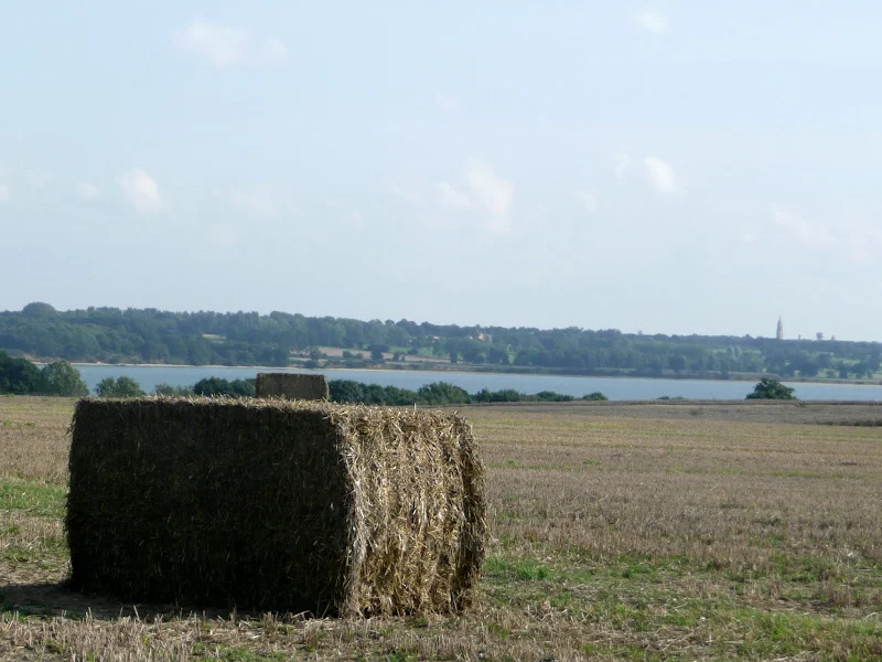
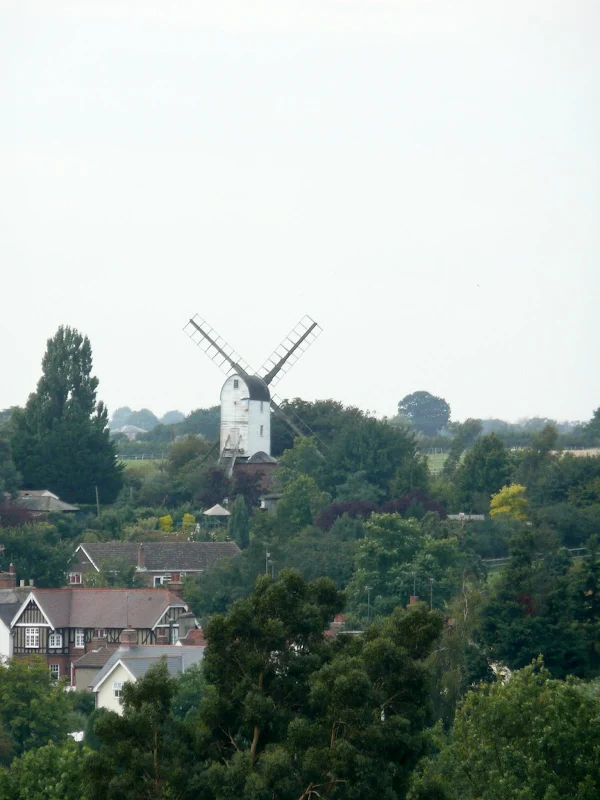
A day walk along the Essex Way
A fine piece of walking along the Essex Way to provide some glorious views of the Stour estuary before turning inland to avoid Harwich and Dovercourt. Estuary views, marsh, woodland and open fields make for a varied scene throughout the walk.

Walk Statistics
- Start location: Manningtree
- End location: Great Oakley
- Distance: miles ( km)
- Total Gain: ft ( metre)
- Total Descent: ft ( metre)
- Min Height: ft ( metre)
- Max Height: ft ( metre)
- Est. Walk Time:
- Walk type: Linear
- Walk Grade: Easy
- Terrain: Footpath, Country Lane

Maps
The following maps and services can assist in navigating this route. There are links to printed maps and links to downloadable GPX route data for importing into navigational software and apps.
- Ordnance Survey Explorer Map
- OS Explorer 184 - Colchester
- GPX Route File
Accommodation
Grange Farm Camp SiteView in OS Map | View in Google Map
- Website
- https://grangefarmcampsite.co.uk/
- Description
- Grange Farm Camp Site, Thorpe-le-Soken - an excellent and recommended site with basic facilities and friendly staff. It is close to the railway station and has a resident owl!
Transport
Train from Thorpe-le-Soken to Manningtree, the station is 15 minutes walk from the campsite. Be aware that at certain times there is no ticket staff and one has to use the ticket machine. This would be easy for single fares but for return fares it offers a multitude of return options and merely tells you that conditions apply to them yet refuses to enlighten you as to what the conditions are.
Return from Great Oakley on this occasion was the number 3 bus operated by First Group. It should be noted that bus routes and operators may change and one should consult Traveline Website to determine the available services.
Walk Notes
This walk was part of a weeks walking expedition along the Essex coast between Manningtree and Maldon. A base-camp was set at the central village of Thorpe-le-Soken which provided the necessary public transport connections to each of the days walks. In addition to the campsite, Thorpe-le-Soken provided restaurants and pubs to relax and muse over the days wanderings whilst rejuvenating with a decent meal and drink.
This days walk started with a train journey from Thorpe-le-Soken to Manningtree with a change at Colchester. The trains are frequent and the Thorpe station is no more than a 15 minute walk from the campsite. It should be noted that the stations in this area make ample use of ticket machines which can cause some confusion as to which ticket is required when taking into account time of travel, day and route. In hindsight it would have been better to have pre-booked the tickets or at least determined the ticket required before the journey.
The walk uses the well way marked Essex Way for most of the route. This long distance trail is picked up in the town, 15 minutes down the road from Manningtree station. This does involve road walking alongside the busy B1352, but there are pavements, and one is soon on the Essex Way when the High Street is reached. The trail leads down to the waterfront at Quay Street and the first views of the extensive Stour estuary.
The path then follows the coastline to the village of Mistley, famously known as the home of Matthew Hopkins, the 17th-century Witchfinder General. Between 1644 and 1647, Hopkins led a ruthless campaign across East Anglia, accusing and trying suspected witches—often on dubious grounds—which ultimately resulted in over 100 executions.
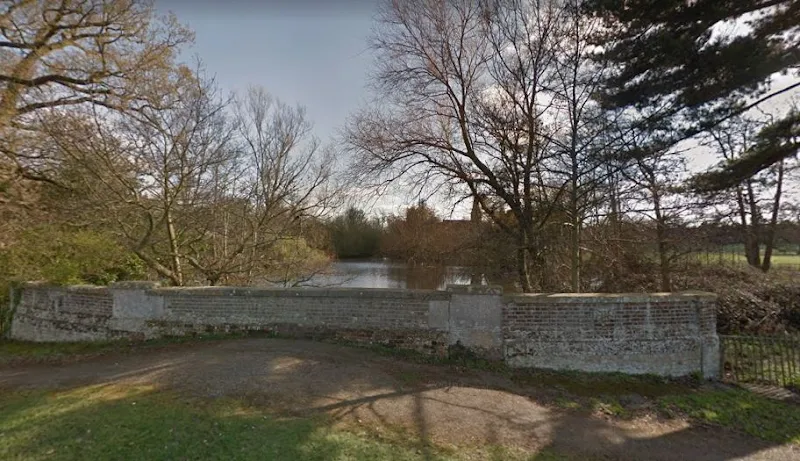
Just before the road enters the village along the waterfront, there is a small, easily missed bridge crossing a pond on the right. The pond’s overflow trickles down through the estuary mud to meet the River Stour. Most motorists pass over the bridge without realizing it’s there; only a low wall beside the pavement and a slight rise in the road give any clue to its presence. This is Hopping Bridge, and in Hopkins’s time, the pond beside it was known as the Ducking Pond. It was used in the grim practice of “ducking” suspected witches: if a woman floated, it was taken as a sign that the baptismal water had rejected her, proving she was in league with the devil. As famously parodied in Monty Python and the Holy Grail, the crowd might then cry, “Burn her!” On the other hand, if the woman drowned, she was considered innocent—but, of course, dead. In short, once Hopkins made an accusation, survival was unlikely.
According to local legend, Hopping Bridge is haunted by the ghost of Matthew Hopkins himself, said to appear on nights of the full moon.

One landmark that stands out as one passes through the village is the pair of 18th century neoclassical towers known as Mistley Towers that proudly stand within a graveyard opposite the village sign. These were originally constructed as the twin towers to the Church of St. Mary the Virgin as part of a scheme to turn the village into a fashionable spa town. Unfortunately the plan did not succeed and the church was demolished in 1870, leaving the towers as a sea-mark for shipping in the estuary. They were renovated in 1950 after falling into disrepair.
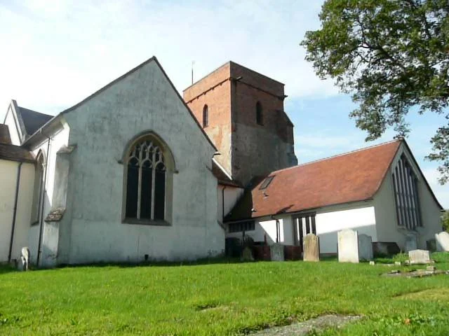
Beyond Mistley, the Essex Way leads inland through to the village of Bradfield. The England Coast Path will take the same route as there is no access along the coastline, presumably because the land is a part of Nether Hall which is all private land. Despite this, there are some commanding views over the estuary and one passes the 13th century church of St Lawrence at Bradfield. Like many East Anglian churches, this one fell into ruins and was restored in the 19th century. There is reputed to be a secret tunnel connecting the church with the estuary that was used in the smuggling days of the 18th century. So many churches and pubs around the coastline of East Anglia have such rumoured tunnels and no doubt the large scale smuggling actions did make use of such methods of concealing their actions from the customs men.
It is from Bradfield that we head back down to the coastline to follow the estuary. This is now part of the Wrabness nature reserve, formerly an MoD mine depot. These days it is a mixture of grazed grassland, ponds, woodland and scrub; fronted by freshwater marsh. A haven for wildlife, insects and flora making it a pleasant ramble to pass through. Having said this, it should be noted that the path does lead along the marshy waterfront and on this occasion it was somewhat boggy in places resulting in one a very soggy boot for Kat.
The path continues beyond the nature reserve until it meets a section of woodland known as Coppers Wood where the waymarkers point the intrepid walker inland. The proposed route of the England Coast Path is to continue through the wood but currently there is no public access and therefore the Essex Way needs to be followed. This trail leads through to the village of Ramsey then cuts across the peninsular at the head of the estuary to then take opposite coast into Harwich.

On this day we had no definitive plans and at Ramsey we were left with two options. Either follow the E2 Euro route through to Parkeston Quay and then walk on to Harwich, or, continue with the Essex Way across country to Little Oakley. Having previously read other walkers accounts of this coastline, we knew that the coast on the Harwich side was inaccessible around Little Oakley due to a coastal explosives factory, therefore any coastal route would have to lead inland. Indeed this is the case with the proposed route of the England Coast Path which diverts up from the coast to Little Oakley.
We sat in the Castle Inn at Ramsey and debated the situation. It was true that we were attempting to walk the Essex coast and to avoid Harwich would, by some purists, be judged as cheating. When preparing for this weeks worth of walking, I had read reports from several walkers who had undertaken UK coastal walks in order to glean accessibility along the coast of Essex. Each of these hikers had their own set of rules on what constituted their method of following the coastline. However, is should be emphasized that we were not attempting to strictly walk the coast and therefore did not have any personal rules to abide by. The whole point of these walks is to set a challenge for a walk, research it and then undertake it with the coast being roughly the line to take. There were limitations to each days walk which were dictated by the public transport connections available. Also, the fact that ultimately this walking expedition was a pleasure activity and not a challenge. And that end point is what swung the decision, we at Griffmonster Walks are country souls at heart and the thought of traipsing the urbanised streets and roads of Parkeston and Harwich was not an idea that particularly enthralled us. Harwich would always be there to visit in the future if we desired.
Therefore, in conclusion, and after a study of the OS map, and taking into account the bus timetables, we decided to take the Essex Way to Little Oakley then follow the a footpath from Oakley Cross through to Great Oakley where we could pick up a bus back to base camp. This proved to be a good decision. The walk was simple enough, there was a pub at Little Oakley where we could not refuse another refreshment break whilst waiting for the late afternoon bus, and it gave a perfect place and transport to resume the walk the next day. The plan worked perfectly.
Directions
From Manningtree station take the road into town where the Essex Way can be picked up along the High Street. Keep to this long distance trail which is well waymarked throughout. There are a couple of hints that may assist. Firstly, at Mistley, the route is directed through the EDME factory yard which at first looks wrong. Just keep going this is a right of way. Secondly, beyond Mistley Heath the route was not clear, compounded by a recently ploughed field. On this occasion, consultation of the OS map and a word from a lady walking her dog soon resolved the way ahead.
After the village of Ramswey the Essex Way crosses the fields to Little Oakley. At the point where the path junctions with another path and the Essex Way is point to the left, take the right. One can either continue straight ahead or then bear left as either path leads into Little Oakley. At the east end of the village, on the Clacton road, just beyond the bend in the road there is a footpath on the right that leads through to Great Oakley. The bus stop is on the main road in the centre of the village.
Pubs
Castle Inn, Ramsey View in OS Map | View in Google Map

- Address
- The Street, Ramsey
- Website
- https://www.castleinnramsey.co.uk/
Pub close to Harwich and offering a campsite as a stop over for those planning a ferry trip from the port. Selection of ale and good food.
The pub is famous for a siege in the early 80's in which Paul Howe, an 18 year old, held a man hostage in the pub. He tried to run and was shot dead by the Police. The story was the basis for an Angelic Upstarts song Never 'ad Nothin
and is documented as framed newspaper articles and the vinyl single on the walls of the pub.
We arrived during a quiet lunchtime when there was little custom, which was satisfying as we could sit and rest from our mornings endeavours without annoyance. The guest ale was Elgoods Cambridge Bitter. I have never been a fan of some of Elgood's ales, which is personal taste rather than beer quality. However this fine example of well hopped bitter imparted a distinctive fresh, crisp bitterness that was the perfect complement to the rewarding ploughman's lunch. Top marks for both the food and the ale.
Ye Olde Cherry Tree, Little Oakley View in OS Map | View in Google Map
- Address
- Clacton Rd, Little Oakley
- Website
- https://www.facebook.com/YOCTLittleOakley/
Small pub on main road through to Harwich. A selection of guest ales.
A choice of four ales were on offer catching the pub before it closed for the afternoon. This was not an issue as we had limited time until our bus arrived. Brentwood Bitter was on offer where both ale and brewery that we had not seen before. A pleasant refreshing balanced bitter beer, perfect for a swift drink.
Image Gallery
Route Validation Cards
Validation Date - 05/09/2010
- Time of Walk: 08:30 to 15:30
- Validators: griff, kat
- Weather Conditions: warm, hazy
- Notes: Initial route undertaken
Summary of Document Changes
Last Updated: 2026-04-20
- 2012-07-10 : Initial Publication
- 2018-12-30 : General website updates and rework notes
- 2021-03-17 : Update website improvements and removal of ViewRanger reliance
- 2021-05-13 : Complete rewrite
- 2021-12-01 : Removal of ViewRanger links due to its imminent demise
- 2025-08-01 : Adjust broken links, review copy, re-introduce pub links
- 2026-01-12 : Major website update with all walks recast to the new format


0 comments:
Post a Comment