Essex Coast - Maldon to St Lawrence Walk Summary
Wednesday, 22 August 2018
|
No comments
|
![]()
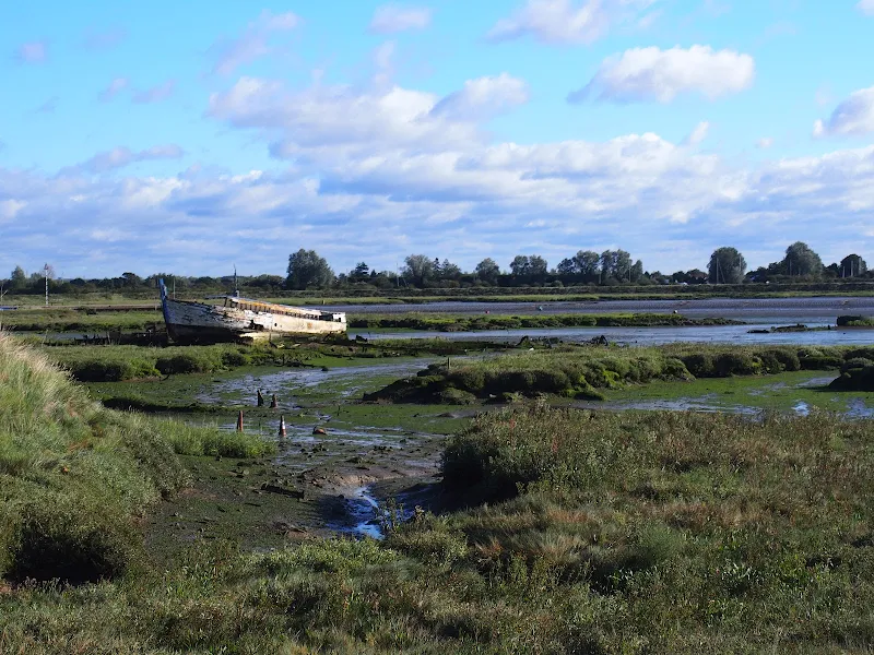
A walk along the southern side of the Blackwater estuary from Maldon to St Lawrence
This 16 miles walk provides great views of the Blackwater estuary with vast open panoramas of the tidal river. Mudflats and gulleys provide havens for wildlife and there are numerous old dilapidate river craft that sit decaying into the mud, forgotten and forlorn.
The path navigates around the numerous creaks and inlets that abound this southern side of the estuary. The path uses the compacted river defence banks which makes it hard on ones feet and offers no shelter from the elements. Given a brisk breeze and light showers, it can take its toll on ones enthusiasm as the path winds in and out of the creaks through to Maylandsea, at times seemingly navigating in the wroing direction.
This specific route does offer a shortcut out of Maylandsea by following the St Peters Way path. This links Lawling Creek and Mayland Creek and provides a short but welcome change of scenery.
The route ends at the Waterside Park in St Lawrence. This provided touring accommodation for those wanting to explore this coastline. Having said this, the park was taken over in December 2017 and it is uncertain whether touring sites are still available. Recent Trip Advisor reports are not encouraging.
Note that public transport in this area is very limited and most major roads can be choked with traffic especially at rush hour. There is a limited bus service between St Lawrence and Maldon.
Few of the pubs and bars offer any real ale and it was a unexpected discovery to find that the modern Blackwater Bar provided a very good example of St Austells Proper Job ale. Admittedly this is far from its Cornish homeland but in the ale desert of this part of Essex it was a just reward for days walking.

Walk Statistics
- Start location: Maldon
- End location: St Lawrence
- Distance: miles ( km)
- Total Gain: ft ( metre)
- Total Descent: ft ( metre)
- Min Height: ft ( metre)
- Max Height: ft ( metre)
- Est. Walk Time:
- Walk type: Linear
- Walk Grade: easy
- Terrain: River defence bank footpaths
- Obstacles: The path is principally along defence banks which can be very arduous on ones feet. At St Lawrence the public footpath along the coast from Stone is inaccessible, blocked up by the sea front home owners. Use the road to the first holiday park where access can be regained

Maps
The following maps and services can assist in navigating this route. There are links to printed maps and links to downloadable GPX route data for importing into navigational software and apps.
- Ordnance Survey Explorer Map
- OS Explorer 176 - Blackwater Estuary
- GPX Route File
Accommodation
Waterside ParkcampsiteView in OS Map | View in Google Map
- Website
- https://www.parkdeanresorts.co.uk/location/essex/
- Description
- Parkdean resorts Waterside Park on the banks of the Blackwater estuary. This was taken over by Countrywide Park Homes in December 2017 amid accusations of intimidation towards holiday park plot owners. It is uncertain whether touring sites are still available here. Certainly during Autumn 2017 the site was amenable and the staff accommodating. More recent Trip Advisor reports since the take over are not encouraging.
Transport
Hedingham - Bus Service
- Service Details
- D1 - The D1 service links Bradwell, St Lawrence, Maylandsea, Latchingdon and Maldon. This is a limited service which appears to get cut back each year. As of 2018 it was run by Hedingham Coaches but may well change in the future
- Timetable
- Essex Bus Timetables
Route Validation Cards
Validation Date - 2017-09-13
- Time of Walk: 08:30 to 16:00
- Validators: Griffmonster, Kat
- Weather Conditions: Clear day with blustery showers
- Notes: Initial route undertaken
Summary of Document Changes
Last Updated: 2026-04-20
- 2021-03-17 : Update website improvements and removal of ViewRanger reliance
- 2021-12-01 : Removal of ViewRanger links due to its imminent demise
- 2026-01-12 : Major website update with all walks recast to the new format


0 comments:
Post a Comment