Route details, maps, pubs, features, local history and folklore for a wide variety of walks focusing primarily on Norfolk and Suffolk

Walks
Showing posts sorted by relevance for query st lawrence. Sort by date Show all posts

Thursday 23 August 2018

Essex Coast - St Lawrence to Tillingham Walk Summery

Salt marsh

A 16 mile walk along the Blackwater estuary from St Lawrence to Tillingham

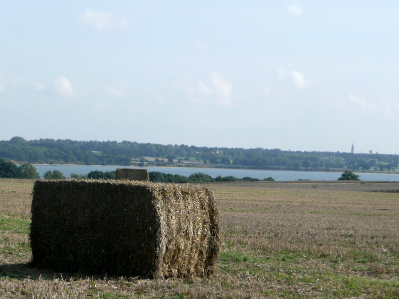
The area that is bordered by the Blackwater Estuary to the north and the River Crouch to the south is known as the Dengie peninsular, a somewhat isolated area of marsh and low lying farmland. The remoteness of this area is its beauty and given the clear blue skies and a little warmth in the air this can be a true delight to walk.

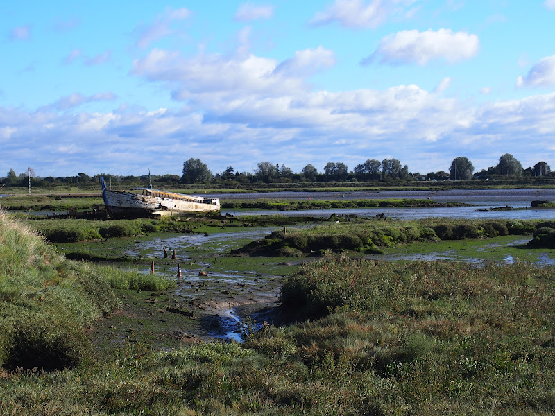
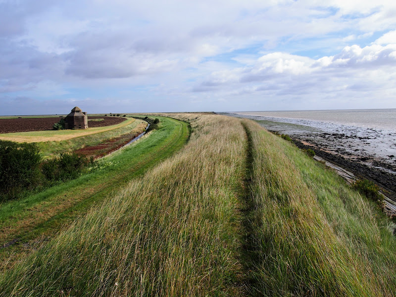
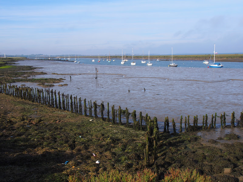
The route detailed here heads along the Blackwater estuary, passing Bradwell nuclear power station as the coast slowly curves around from the estuary to face the open sea. In the distance, Mersea island is easily seen and sitting on the mudflats as river meets sea, visible at low tide, are a line of concrete filled barges that were sunk to provide a sea defence for the marshes. Further along is the remote St Peters Chapel, the oldest church in England and said to have been constructed in AD654. It is a working place of worship and well worth the visit into its humble and peaceful confines.

It is at this point that the long distance trail known as St Peters Way reaches its destination. This 45 mile trail starts at Chipping Ongar and passes through the Essex country side and villages in its journey to the coast. This well waymarked trail serves as the return for this route to St Lawrence. The trail leads across the low lying fields and marsh into the village of Tillingham arriving through the church yard. There is a pub on the green where one can rest ones weary legs before the final stage back to St Lawrence.

The St Peters Way slowly climbs to some 30m after leaving Tillingham, and this provides glorious views of the coastline. The route departs the trail at St Lawrence to follow a country lane out onto the main road. This is busy and caution should be observed when walking along this short section to the road down to St Lawrence Bay. There is a footpath marked on the OS that would negate this section. However this was certainly inaccessible when walking the route in September 2017. .

Wednesday 22 August 2018

Essex Coast - Maldon to St Lawrence Walk Summary

Salt marsh

A walk along the southern side of the Blackwater estuary from Maldon to St Lawrence

This 16 miles walk provides great views of the Blackwater estuary with vast open panoramas of the tidal river. Mudflats and gulleys provide havens for wildlife and there are numerous old dilapidate river craft that sit decaying into the mud, forgotten and forlorn.

The path navigates around the numerous creaks and inlets that abound this southern side of the estuary. The path uses the compacted river defence banks which makes it hard on ones feet and offers no shelter from the elements. Given a brisk breeze and light showers, it can take its toll on ones enthusiasm as the path winds in and out of the creaks through to Maylandsea, at times seemingly navigating in the wroing direction.

This specific route does offer a shortcut out of Maylandsea by following the St Peters Way path. This links Lawling Creek and Mayland Creek and provides a short but welcome change of scenery.

The route ends at the Waterside Park in St Lawrence. This provided touring accommodation for those wanting to explore this coastline. Having said this, the park was taken over in December 2017 and it is uncertain whether touring sites are still available. Recent Trip Advisor reports are not encouraging.

Note that public transport in this area is very limited and most major roads can be choked with traffic especially at rush hour. There is a limited bus service between St Lawrence and Maldon.

Few of the pubs and bars offer any real ale and it was a unexpected discovery to find that the modern Blackwater Bar provided a very good example of St Austells Proper Job ale. Admittedly this is far from its Cornish homeland but in the ale desert of this part of Essex it was a just reward for days walking.

Sunday 26 August 2018

Essex Coast - Burnham-on-Crouch to Bradwell Walk Summary

Salt marsh

A 15 mile walk along the remote Essex coast from Burnham-on-Crouch to Bradwell

Many publications have stated that the section of the Dengie peninsular that borders the sea, east of the town of Burnham-on-Crouch, is the most remote place in the entirety of England. It is true that this isolated area of Essex is far from any major centres of population but walking this coast path one is never completely devoid of the signs of civilisation. Although one may never meet another soul on this lonely path, there are farms and machinery working the fields, haystacks and narrow lanes heading inland. All evidence that civilisation is not far away and, indeed, the nearest town is never more than 5 miles away as the crow flies.

The route is predominantly defence banks with a panorama of flat marsh to one side and acres of flat farmland on the other leaving with just the defence bank the tallest structure around. This leaves one distinctly exposed to the elements and faced with wind and rain it can require additional effort to push onwards. There are wide areas of cut grass on the landward side of the banks which can be utilized as a sheltered walking refuge when the going becomes a struggle or when the top of the bank is overgrown as found it some sections in this instance.

It has to be said that the constant unchanging scenery of this flat landscape can become somewhat monotonous as the miles slowly slip away. The smallest of landmarks then become a haven for curiosity. A sluice gate. A WWII pill box. Discarded tyres and debris in the marsh mud. The skeletal remains of a ship rotting on the marsh. A metal 5 bar gate with numerous plastic pieces of jetsom and flotsam seemingly purposely tied to it cluttering the mind with wonder as to its intentions.

The final part of the walk leaves the coast to navigate up the lanes to the village of Bradwell. There is a bus service from here although buses are few and far between. The D4 service returns to Burnham-on-Crouch. The alternative, as in this instance where accommodation was at St Lawrence is the D1 Service which links Bradwell, St Lawrence and the village of Latchingdon where the regular 31 service proceeds to Burnham-on-Crouch.

Friday 14 May 2021

Essex Coast Walk - Manningtree to Great Oakley

Overlooking the Stour estuary

A day walk along the Essex Way

A fine piece of walking along the Essex Way to provide some glorious views of the Stour estuary before turning inland to avoid Harwich and Dovercourt. Estuary views, marsh, woodland and open fields make for a varied scene throughout the walk.

Sunday 30 December 2018

South West Coast Path - Looe to Plymouth

The Tamar Estuary

A 20.6 mile walk along the South West Coast Path between Looe and Plymouth.

This is the first section of the South Cornwall part of the South West Coast Path. There is a link between the two ends of the walk using the railways, changing at Liskeard. The walk is fairly easy in comparison with some sections of the South West Coast Path though it does have a few strenuous climbs. This particular walk misses out Rame Head in order to keep the distance down and allow connection of trains on the limited Sunday service.

Friday 4 January 2019

A Walk Around the Churches of Knodishall and Friston

An 8.4 mile circular walk around the Suffolk villages of Knodishall and Friston

An easy ramble across the Suffolk countryside, with the highlight being the hidden ruins of St Peters Church in the old parish of Buxlow, now a part of Knodishall. There's some fascinating history on this walk along paths that are off the beaten track but nonetheless well maintained.

Tuesday 17 December 2019

Lincolnshire Coast Path - Boston to Wrangle

Hobhole Drain from Freiston Bridge looking north

An 10 mile beach walk from Boston to Wrangle

An alternative route to the coastal defence banks that provides a change to the marsh views. Open flat farmland, tiny hamlets, large churches and plenty of pubs along the way. Not strictly part of a coast path but this route roughly follows the coast of medieval times when Wrangle boasted the third largest harbour along this section of coastline.

Saturday 28 April 2018

Norwich Riverside Walk

View to Whitefriars bridge

A simple 2.5 mile walk alongside the River Wensum through Norwich.

This picturesque walk through the centre of Norwich links the Marriott's Way at Barn Road roundabout on the inner ring road with The Wherryman's Way and Boudicca Way at Norwich Railway Station. There is a lot of history to the bridges over the River Wensom and associated folklore which is detailed in the features to this walk.

Walk Summaries

Latest walk summaries are basic information sheets for walks that have yet to be fully documented. These provide links to maps, public transport and walks stats, although detailed notes and features are not included.

Latest Walk Summaries

Featured Walk

In Search of Sizewell Chapel

A 10 mile walk following the southern side of the parish boundary of Leiston in Suffolk This walk follows the route of a 17th century peramb...

What is GPX

All you need to know about GPX, electronic mapping and how to use modern apps and mobile devices as navigation devices

Popular Walks

Maps