The Fonnereau Way to Ipswich
Wednesday, 21 November 2018
|
No comments
|
![]()

A 12 mile walk between Woodbridge and Ipswich incorporating sections from the Fonnereau Way, the Sandlings and the Fynn Valley Way
This walk links the railway stations of Woodbridge, Westerfield and Ipswich with scenic views along the estuary at Woodbridge and the Fynn Valley before entering Ipswich from the west through the historic parkland known as Christchurch park which dates from the 12th century which includes many historic features and a mansion that is open to the public.

Walk Statistics
- Start location: Turban Centre, Woodbridge
- End location: Corn Market, Ipswich
- Distance: miles ( km)
- Total Gain: ft ( metre)
- Total Descent: ft ( metre)
- Min Height: ft ( metre)
- Max Height: ft ( metre)
- Est. Walk Time:
- Walk type: Linear
- Walk Grade: Easy
- Terrain:

Maps
The following maps and services can assist in navigating this route. There are links to printed maps and links to downloadable GPX route data for importing into navigational software and apps.
- Ordnance Survey Explorer Map
- OS Explorer 197 - Ipswich, Felixstowe & Harwich
- GPX Route File
Transport
First Group - Bus Service
- Service Details
- 64 - First Group 64 service connects Ipswich, Woodbridge, Wickham Market, Saxmundhamm, Leiston and Aldeburgh.
- Timetable
- Suffolk On Board Website
Walk Notes
This route uses three independent trails. The first section, along the River Deben follows the The Sandlings long distance path. The second section continues along the Fynn Valley Walk to Tuddenham. The final section presents an amble across the fields to pick up the The Fonnereau Way which leads into Ipswich. The Fonnereau Way is named after the family who were the owners of Christchurch Park and the Elizabethan Mansion where this path has its end. Christchurch Park is a little gem of discovery that really makes this walk well worth the effort and a fitting finale. I thoroughly recommend walking it in this direction and then taking ones time to meander through the park and look around the mansion. The parkland around the mansion dates from the 12th century and this is reflected in the ancient knotted trees that line the path through the park. I have never been keen on Ipswich as a place or destination but this parkland has changed my perception of the town somewhat.
Route deviations and alternative routes
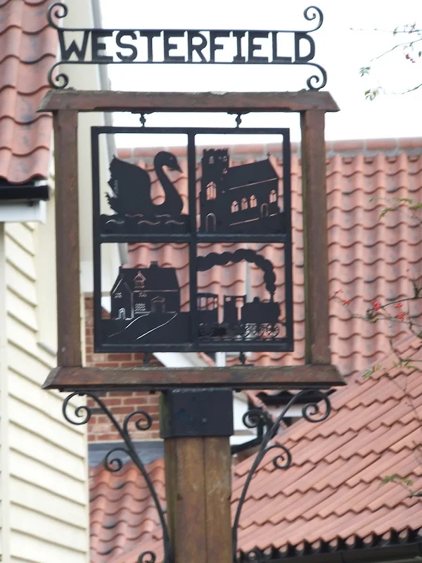
The official route takes the happy wanderer through the fields to the west of Westerfield but we decided to walk along the road into the village in search of refreshment and was rewarded with two pubs, the Swan and The Railway Inn, both of which are worthy of a visit. There is a pavement along the roadside leading into the village and access back to the route is just down the road from the Railway Inn so in my opinion this is a preferred option.
This was not the only deviation we took, there is also an alternative path at Martlesham which crosses the railway rather than walking around to the road and under the railway. This was more an exploration as we had taken the longer route when walking the Fynn Valley Walk. This path, clearly marked on the OS map, cuts a corner but caution should be taken crossing the railway line where there are steep steps up and over the railway embankment.
A little further along the route we encountered a jogger who gave us instructions for the path to follow as it had recently been ploughed over. This was handy advice, as even though we could have navigated across the fields with the OS map it added that certainty that we were heading along the correct course. Further along we met up with an elderly couple out walking their dog who seemed pleased to have company and conversation as we walked through to Tuddenham. The talk was of pubs, of the the number of pubs closing down for good. Of the recommended local pubs that offered good food as well as ale. Of the pubs we were planning on visiting. Then the talk turned to the new proposed Sizewell C power station. Of the impacts this would have on the locality which they regularly visited. Of the memories of Sizewell B construction and its social impacts. Back then Leiston was described to be like 'the wild west' full of drunken contractors.
A planners destruction of the countryside
It was with dismay that recently the news of a new Ipswich housing development has been released. This development is set to obliterate the green field landscape that separates Westerfield from Ipswich through which the The Fonnereau Way passes. The report states that 4,500 new houses are planned for this area which is absolutely astounding. What really annoys me with these massive housing developments, apart from the destruction of the landscape, is that East Anglia has limited water resources and year on year we are told that water is a precious commodity and we should ration ourselves with the quantities we consume. Yet despite these pleas the regions planners still insist on increasing the housing and attracting more business and more population to the area. Surely if the resources are not there, the population should be limited or am I just being stupid? Earlier this year Norfolk County Council announced a similar scheme, this time a plan to concrete over part of the broads and fill it full of new housing development. I may be a critical misaligned old git but to me it seems that this is more about lining the pockets of developers than choosing the best options for the area. So, if you want to walk The Fonnereau Way I suggest you should get your walking boots on sooner rather than later as this will soon be a traipse through another housing estate.
Directions
The walk follows the the banks of the Deben around to Martlesham Creek where it meets the River Fynn. The path then follows the river's course through Little Bealings, Playford and Tuddenham St Martin. There is then an amble across the field where the route then follow the Fonnereau Way into Ipswich. The entire route is marked out with the distinctive East Suffolk Line Walks waymarkers
Woodbridge to Martlesham Creek
The footpath follows the Sandlings route along the riverside. This is an easy to follow section, keeping to the path as around Martlesham Creek where it heads into Sluice Wood where there is a way marker with four footpaths to choose from - the Sandlings continues straight ahead, there is a footpath to the left around the creek and to the right is The Fynn Valley Way which this walk now follows.
Martlesham Creek to Tuddenham
Continue through Sluice Wood until the path emerges onto a road at Martlesham. Keep in the same direction to the road junction, turn right and cross the road. There is a track between the houses on the left, this leads down to a field which it crosses, then over the railway and across another field to the embankment of the main A12 trunk road. Follow the embankment down to a tunnel through to the far side. Turn left and keep to the footpath to Little Bealings. At the road, turn right, then take the path on the left down by the side of the church and onto a little road with houses alongside. Bear round to the left ad follow the footpath through to Playford. Once on the road at Playford keep bearing round to the left until the road junctions with the main road through the village. Turn right, then left down a lane. This eventually leads onto a footpath that leads across the meadows along the Fynn Valley. The path keeps to the field boundary and is easy follow. There is a lack of a way marker to point one down to Rosemary Bridge and an OS map does assist in finding this. IF this is missed the path continues onto a lane and out into Tuddenham to meet back with the correct route which follows the river.
Tuddenham to Ipswich
Turn left on the road at Tuddenham and keep to this, ignoring the route as it twist to the left. Just past Poplar Farm there is a footpath across the fields to the Westerfield road. Turn left and follow the pavement down into the village, across the railway and on the second field boundary on the right there is a footpath. At the end turn left and follow the footpath into the suburbs of Ipswich. This emerges on the busy ring road. Turn left, cross the road and continue down The Avenue. This leads into Christchurch Park and through to the Mansion and then out onto Soane Street. Turn right, then left down Tower Street. Keep heading straight ahead until the bus station is reached.
Pubs
The Swan, Westerfield View in OS Map | View in Google Map

- Address
- Westerfield Road, Westerfield
- Website
- https://www.debeninns.co.uk/swan/
The original Swan Public House was located across the road to the present building in a house that is now called the Slade. It closed its doors in 1829 as a result of the enclosure of Westerfield Green. The current building opened about a year later. The pub is family oriented with emphasis placed on good value-for-money food in well presented surroundings and amicable atmosphere. A selection of Adnams ales is on offer.
The pub was closed down in January 2013 and then purchased by Deben Inns in June 2013. It has undergone a refurbishment and has now reopened.
The pub was very busy with a lot of custom arriving at the same time as we arrived. The barstaff made it known that we were on their radar and we eventually got a pint of Adnams Lighthouse. Refreshing. Very much a family pub centred around food though we certainly didn't feel out of place with a pint of ale and packet of crisps.
The Railway Inn, Westerfield View in OS Map | View in Google Map

- Address
- Westerfield Road, Westerfield
- Website
- https://www.therailwaywesterfield.co.uk/
Originally known as the Station, then subsequently called the Railway Hotel, this pub dates from the mid 1800's. The Pub is now called the Railway Inn, having dropped the 'Hotel' in 1970. It is a popular bar and restaurant with a log fire and the walls adorned with old railway memorabilia. Ales are Adnams.
We arrived as the pub was about to close for the afternoon, therefore it was empty of custom but was nonetheless allowed to sit and casually drink some beer. Some fascinating pictures of old trains on the walls for an old train spotter! We opted for the not widely available Adnams Explorer. This has changed over recent years in my opinion. It used to be a very dry tasting golden ale but has now become a very pleasant summer ale full of citrus and grapefruit notes with a good bitterness which delivers a refreshing clean taste to the palate.
Features
Christchurch Park and MansionView in OS Map | View in Google Map
The grounds of what is now Christchurch Park date from the 12th century when it was part of the Augustinian Priory of the Holy Trinity. Even before this time the main north to south route is thought to have been an old Saxon path. The priory lasted until the Dissolution of the Monasteries in 1536 when the estate was seized by the crown and then sold on to Paul Withipoll, a London merchant, in 1545. His son Edmund demolished the priory and built Christchurch Mansion in its place during the years 1548 to 1550.There are no remains of the original priory apart from a disused lion's head water fountain which the Augustinians had provided for the poor of Ipswich. The two ponds that are in the park are thought to have originally been fishing ponds for the priory.
After the estate was passed to the Devereaux family it was bought by Claude Fonnereau in 1735 and by 1772 parts of the park were given public access. In 1848 Ipswich Corporation leased 13 acres of the land for use as a public park. The whole park was granted public access when Felix Cobbold bought the estate and sold the land to Ipswich corporation along with the mansion, the entire deal being completed in 1895.
The park contains many features including:
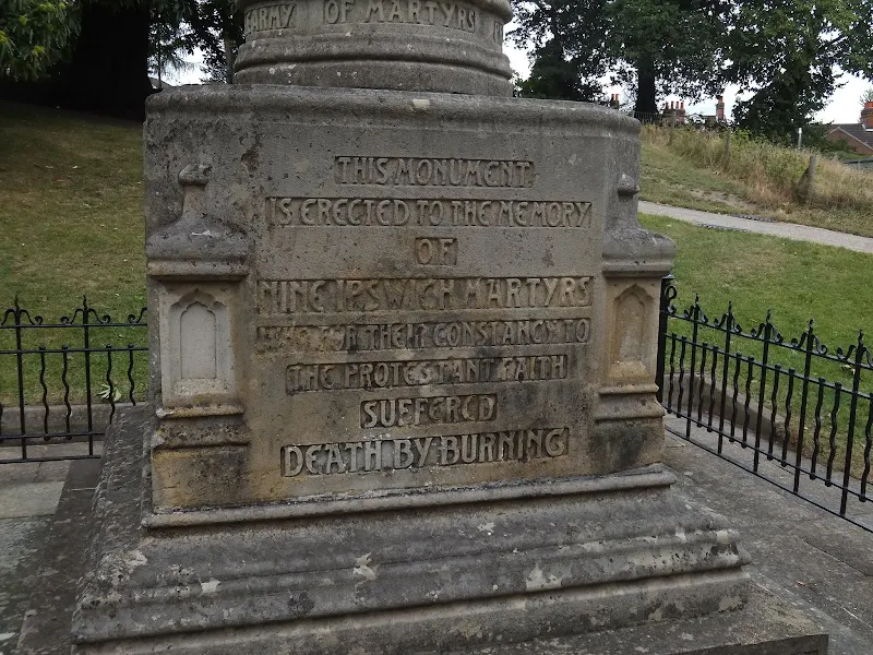
- A memorial to the Ipswich Martyrs dating from 1903. This was a group of nine people burnt at the stake in the centre of Ipswich for their Protestant beliefs around 1538-1558. The monument has a square, stone base that bears a testament to the martyrs on the front, and lists their names on the other three sides.
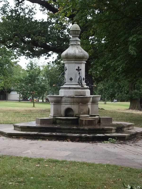
- The Burton Fountain - a drinking water fountain donated by Sir Bunnell H. Burton in 1896. Burton was an Ipswich based merchant and Chairman of the Governors at Ipswich School. He was knighted in 1934 for political and public services in Ipswich and died in 1943.
- The Ice House - hidden in the ground, this is a Grade II listed building dates from around 1735 and was used to store winter ice collected from the ponds to provide chilled food in the summer months
- Two War Memorials - these commemorate the fallen servicemen from the Boer War, World War I and World War II as well as later conflicts
- The Brett Fountain - donated by John Brett in 1862 after he had witnessed children playing in the Arboretum and having no drinking water
The Mansion is now a grade I listed building and houses a Museum and art gallery featuring paintings by artists including John Constable and Thomas Gainsborough. There are also rooms preserved in their original condition from Tudor times including the kitchens and servants quarters. The house is open to the public six days a week (Tuesday to Sunday) from 10am until 5pm and there is no charge for entry though donations are welcome.
Spooky Goings On
As with most old buildings Christchurch Mansion has numerous ghostly tales and stories. Visitors are often caught unaware as they browse around the old house. One woman who was walking through the corridors admiring the old paintings that adorn the walls happened to catch a movement out of the corner of her eye. She turned to witness a painting turn itself around unaided. Another visitor, who was accompanied by her daughter, described feeling a cold shiver as they stood in one of the display rooms. At that point she caught sight of a woman, dressed in Victorian clothing, glide past them and on through the closed glass doors to the room.
And its not only visitors who are party to the mysterious goings on. Steve Parkes, one of the Mansions assistants witnessed a spooky occurrence in 2010. He was preparing a room for an art exhibition and one of the exhibits was standing on an easel by the door to the room. In full sight he witnessed both the easel and painting lift off the floor then fly backwards about six feet before landing on the floor. A similar experience is said to have happened 14 years previous to this.
There are also reports of children being heard laughing and giggling around the kitchen area, sometimes accompanied by the ghostly figure of a maid.
References
Image Gallery


Route Validation Cards
Validation Date - 2012-09-01
- Time of Walk: 10:00 to 16:00
- Validators: Griffmonster, Kat
- Weather Conditions: Overcast
- Notes: Initial route undertaken
Summary of Document Changes
Last Updated: 2026-04-20
- 2012-12-03 : initial publication
- 2012-12-22 : Increase granularity of Pub locations for both text and schema.org markup
- 2013-04-11 : The Swan at Westerfield now closed
- 2013-07-18 : The Swan at Westerfield acquired by Deben Inns
- 2013-10-18 : The Swan at Westerfield now reopened
- 2018-11-21 : general updates
- 2021-03-17 : Update website improvements and removal of ViewRanger reliance
- 2021-12-01 : Removal of ViewRanger links due to its imminent demise
- 2026-01-12 : Major website update with all walks recast to the new format


0 comments:
Post a Comment