Ouse Valley Way - St Neots to Houghton
Sunday, 9 December 2018
|
No comments
|
![]()

A 14 mile walk along the Ouse Valley Way from St Neots to Houghton
A perfect river side walk following the gentle flowing River Ouse as it meanders past nature reserves to Godmanchester. From here there is easy access into Huntingdon or across the meadows to Houghton and its infamous mill. A perfect way to enjoy a summers day.

Walk Statistics
- Start location: St Neots
- End location: Houghton
- Distance: miles ( km)
- Total Gain: ft ( metre)
- Total Descent: ft ( metre)
- Min Height: ft ( metre)
- Max Height: ft ( metre)
- Est. Walk Time:
- Walk type: Linear
- Walk Grade: Easy
- Terrain: Footpath with some road walking at the start
- Obstacles: River side path with obvious hazard of the river

Maps
The following maps and services can assist in navigating this route. There are links to printed maps and links to downloadable GPX route data for importing into navigational software and apps.
- Ordnance Survey Explorer Map
- OS Explorer 225 - Huntingdon & St Ives
- GPX Route File
Accommodation
Houghton Mill CampsiteView in OS Map | View in Google Map
- Website
- https://www.nationaltrust.org.uk/holidays/cambridgeshire/waterclose-meadows-campsite
- Description
- National Trust owned campsite that is located directly in front of Houghton Mill
Transport
Whippet - Bus Service
- Service Details
- 45/45A - Whippet buses 45/45A bus service linking Huntingdon, Houghton and St Ives
- Timetable
- Whippet 45/45A
Various - Train Service
- Service Details
- ECML - East Coast Main Line railway services
- Timetable
- East Coast Mail Line
Walk Notes
Houghton is probably not the most likely end point for this walk with Huntingdon being the direct connection for public transport to St Neots. However Houghton offers a campsite in the delightful settings of its Mill and its charming village. There are regular buses from the village into Huntingdon where a frequent train service operates between Huntingdon and St Neots.
The walk, in this instance, begins at St Neots railway station and navigates along the road to Paxton where the official Ouse Valley Way is picked up at the point where the river splits, this being the site of the former Little Paxton Paper Mill. This location has had a mill since Saxon times but in more recent years the area has been redeveloped and a menagerie of modern houses and apartments fill the area. Over a thousand years of history torn down for the sake of housing that will probably not last a tenth of that. In these days where green energy is being touted as the way forward surely it would have been more in keeping with the area to have an electricity generating mill. I guess building houses is a bigger source of income for developers. To the west, more development occupies what used to be Paxton Park, once the site of Paxton Park House that later became a school and then a maternity hospital before being demolished in 1959. Progress and expansion has changed this area a great deal in modern times.
Moving further downstream one soon encounters mile after mile of nature reserve that has been carved out of the former gravel workings. Large lakes, expanses of meadow along with scrub and woodland offer habitats for a wide variety of wildlife including what the reserve is most renowned for, its nightingales and cormorants. The reserve covers the distance through to the village of Offord Cluny, which is the site of another mill that has since been turned into modern housing for the commuter belt that surrounds Cambridge and the A14 corridor. The village does provide the opportunity for refreshment with the Swan pub at the T-junction in the village and, for those who are prepared to wander a little further, there is also the Horseshoe at neighbouring Offord Darcy and was recommended by a group who we met walking out of the village.
Offord Cluny offers distinct memories for myself from childhood days. Way back in the 1970s, Houghton was the destination for many family summer holidays. This was not just a camping expedition but a whole adventure straight out of the pages of an Enid Blyton Famous Five book. My dad would drive the old family black Ford Popular with all the camping gear, including canoes, whilst the rest of the family would cycle the 25 mile distance from Rushden in Northamptonshire. This had the added bonus of having bikes for the duration of the holiday and gave a true sense of adventure in getting to and from the campsite that would leave a lifetime of lasting memories. One could not have wanted for a better holiday.
Offord Cluny stood out in the days bicycle ride as this is the crossing point of the East Coast Main Line Railway and being railway enthusiasts, ok I admit it, train spotters, then this was an enticement for my brothers and myself to hurtle ahead, down the steady hill from Buckden in order to watch the trains speed past before our mother caught us up. Deltics, English Electric Class 40s and Brush 31s would offer exotic sights that were seldom seen on our local Midland Mainline. Without doubt the Deltics were the locos that inspired the most enthusiasm with their distinctive guttural sound of the powerful throbbing Napier diesel engines. A true sight and sound to behold.
Today the railway still passes through the village, the railway crossing is still there with its wide expanse of lines that is more than the average railway crossing. The crossing gates are now replaced by the automatic barriers and the traditional wooden signal box has been replaced by a modern steel and brick construction. As for the trains, the line is now electrified and the diesels have been replaced by somewhat characterless units that rush through at exasperating speeds with little sound or sign of effort. Not real trains in my opinion. But then my old dad said the same when the old steam engines were replaced by the diesels.
As all those years ago, so on this occasion, it was sad to leave this crossing after waiting for several trains to pass through. But leave we did to wander through Buckden Marina, with its row upon row of luxury holiday mobile homes accompanied by expensive cars. It did make one wonder whether these folk had been drawn to the place after spending their youth hurtling down the gradient from Buckden on their bicycles to watch the trains. Maybe not. Maybe they are just people with too much money to burn who never had the youthful adventures going on summer holidays in the simple manner we used to do. Some things money cannot buy.
The next stretch of the walk takes one through to Godmanchester. The path passes through a caravan site and over a branch of the river at Bromhome Bridge. 300 yards to the left is the haunted Nuns Bridge which carries the old road into Huntingdon and is the subject of the feature of this walk. I seem to remember the bridge and the building of the modern replacement with the road realignment during the 70s and thinking that things were progressing far too quick. Back then I would never have believed this little market town would have grown to the sprawling urbanisation that it has now become. Sad. Very sad and how I long for those old days of typical English towns that have now all gone.
Passing under the railway one then emerges onto the vast expanse of Port Holme, a natural flood plain meadow. King John in 1212 granted a charter to the area which prevented the meadow being divided, developed or enclosed, imposing strict rules on its use. It is a pity he did not do the same for Little Paxton or Offord Cluney. From the 1600's to the end of the 19th century the meadow had a racecourse on it, complete with grandstands and facilities for fairgrounds and other entertainment. A full history of the site can be found at Flood Plain Partnership website.
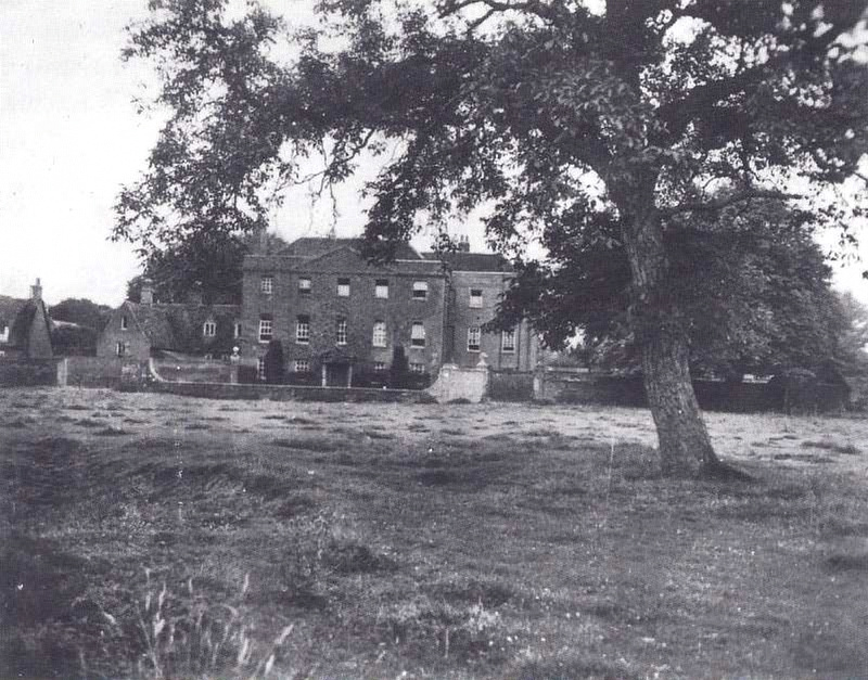
Where the path meets the river at Godmanchester Locks, one should take a minute to peruse across the fields on the southern side of the river. It is here that Farm Hall stands. This 18th century, three storied brick building was employed in the culmination of Operation Epsilon as WWII drew to a close. This secret operation was put into effect during the closing months of WWII and resulted in the capture of ten prominent German scientists involved in Nazi Germany's nuclear research. These men included the renowned Werner Heisenberg, whose uncertainty principle is the foundation of modern quantum mechanics and who, at this point in time, was leading a project to create a functional uranium engine
, what we would now refer to as a nuclear reactor. The men were interned at the heavily bugged Farm Hall, the listening devices utilised to determine how close the Germans had come to developing a nuclear weapon. The scientists had truly believed German physics was way ahead of the Allied efforts. As a result of this false premise, on hearing the news of the atomic bomb being dropped on Hiroshima they became overtly shocked by their own inadequacies.
The translated transcripts of the recorded conversations in the house were inconclusive and even today there is uncertainty as to whether the scientists were explicitly working towards a bomb or were only seeking to use the physics as a method to harness energy. Whatever their intentions, they came very close to achieving criticality in the nuclear pile where a self sustaining chain reaction would have been achieved. However they had no fail-safe method of controlling such a reaction other than a lump of cadmium that would be thrown into the pile in the event of an emergency. Had criticality been reached they most likely would have blown themselves all to kingdom come. For more information I would recommend reading the Beyond Uncertainty, a biography of Heisenberg compiled by David C Cassidy.
One could spend a little time exploring Godmanchester but for this walk we stop for refreshment before continuing on across the meadows to the river crossing at Houghton. The end of the walk is at the campsite but more on that in the next stage of this walk.
Directions
Riverside walk from St Neots to Houghton near Huntingdon
Leave St Neots railway station and turn right onto the road. This is Priory Hill Road which leads alongside the railway then bends around to the left with open fields on the right. At the crossroads proceed straight over onto Mill Lane. At the T-junction, turn right and follow the road over the two river bridges. After the second bridge take the footpath on the right that leads down by the river.
From this point the path is well marked. Keep ahead and ignore all other paths that lead around the nature reserve lakes.
As Offord Cluney is approached, distinctive by its church on the opposite side of the river, the path turns as the river separates into a mill stream. Before a weir is met, the path virtually turns back on itself in order to navigate across a stream via a footbridge. The path then leads out onto the road.
For refreshments turn right and follow the road across the river and the railway crossing. The Swan pub is located on the left at the T-junction.
To continue turn left at the road and follow the road around to the entrance to the holiday park. A waymarker directs the route through the park along the laid out roadways.
Continue along the riverside towards Brampton Lock. At this point follow the path away from the river alng a track through a touring park, then take the track on the right which leads across Bromholme Bridge, then under the railway and onto Port Holme, an expansive meadow. Keep in a straight line across the meadow aiming for the locks on the far side. Proceed across the bridge by the locks and keep to the riverside path. There is a bridge that leads onto the The Causeway in front of the river where the Royal Oak pub is situated.
At this point, if one wants to terminate the walk at Huntingdon, proceed northwards onto Post Street and follow this through to the town. To continue to Houghton, take the entranc into the church on Post Street just past the roundabout with The Causeway or use Chadley Lane just off the roundabout.
At the church proceed around to its easteern side and follow the path keeping left passing the cricket green and then under the A14 road. The path navigates around one side of a lake and then continues onwards up to a disused railway line. Turn right and follow the trackbed for 450 yards where a path diverges from the line on the left.
Follow the path around the lakes until it meets the main river. Where the river branches continue around the creek until a footbridge enables access across and the footpath returns to the main river. Continue to Houghton locks and take the bridge across the river, following the path around to Houghton Mill. A passage leads through the mill buildings and the campsite is then immediately on the right, with the village accessed by turning left and following the road.
Pubs
The Swan, Offord Cluny View in OS Map | View in Google Map

- Address
- High Street, Offord Cluny
The original building was known as Ye Olde Swan and this burned down in 1763. According to Ghost Pubs website (link no longer available), this inn is reputedly haunted by several ghosts that have been encountered over the years. The stories of the alleged manifestations are said to centre around a former landlord who had an affair with the cleaner, a girl called Lily who subsequently became pregnant and died in what it states as sad circumstances
. Another story relates that the pub was used for a military court martial after which the accused soldier was hanged and whose ghostly presence makes itself known as a young man with fair hair and wearing a leather jerkin.
The hostelry is currently very much a locals pub offering sports TV and pub games. A couple of ales are on offer.
Very basic pub and just a few locals watching the Saturday afternoon sport on the bar TV. As with most little locals the ales are a bit of a token gesture but the Camerons was a thirst quencher after a hot mornings walking. Having said this it has to be stated that both the locals and staff were friendly and offered conversation which is what a pub is all about.
Royal Oak, Godmanchester View in OS Map | View in Google Map

- Address
- The Causeway, Godmanchester
Records show this riverside property was a pub as early as the mid 19th century. Presently it serves as a community pub with sports, pool and regular entertainment. The exterior present an imposing Georgian frontage that overlooks the river whilst inside there are a multiple multi-level drinking areas and an external courtyard. Ales available.
Busy riverside pub and unfortunately no food on offer which was a disappointment. Decent pint of ale and a bag of crisps did their job of soothing some aching legs
Features
The Nuns BridgeView in OS Map | View in Google Map
Although not exactly specific to this walk, this legend is not too far removed and provides a bit of local folklore to cogitate over during ones meanders. As the Ouse Valley Way passes over Bromholme bridge between Buxton and Godmanchester, to the left, across the meadow is a concrete road bridge that carries the main road into Huntingdon over the Alconbury Brook. This modern bridge was constructed in the 1970s as the original bridge was unsuitable for the traffic that it carried. The original ancient bridge still exists and sits adjacent to the new road and is of brick construction with five spans, the three central spans dating from the 15th-16th century. It is this bridge that is locally known as the Nuns' Bridge and which the legend centres around.
Beyond the road is the grounds of Hinchingbrooke House which stands on the site of an old Norman Church. By the year 1200 the church had been converted to a Benedictine nunnery, known as the Priory of St. James, which lasted until the dissolution of monasteries in 1536. The building is presently used as the sixth form college for the Hinchingbrooke school. There are reminders of the nunnery still in existence in the present building including two stone coffins that were discovered under the stairs in 1834 by builders and are said to be the source of many sightings of ghostly nuns that have been encountered on the staircase.
The legend attached to the bridge concerns a particular nun from the convent who had fallen in love. The identity of the girls suitor depends upon the rendition of the story that is being told. In some instances it is a monk although further detail is never forthcoming, in other instances it is a neighbouring nobleman who requests that the nun be released from her vows so that they could marry. This rendition of the story is more detailed and goes on to tell of how her family refuses the request as it would bring shame on the family. In order to resolve the impasse her brother offers to assist and plans to meet her at the bridge. What happened on that fateful night of the meeting is unknown but her body was found in the river the very next day. Her lover naturally claimed that her brother was the culprit and had drowned her to save the family honour but nothing was proved. What became of the nobleman or the brother is never stated.
In the case of the monks story, the illicit affair is discovered and the two of them are executed for their misdemeanour's. The location of their execution and the site of their burials is never detailed. The fact that the story does not specifically mention the bridge does beg the question as to why there is a connection to the bridge, unless it was indeed the place of execution.
An interesting addendum to this story came in 2014 when the two coffins that had been discovered under the stairs at Hinchingbrooke House were scrutinised by Kerry-Ann Milic, a Forensic Biologist at Anglia Ruskin University. Each coffin contained a skeleton which had historically been presumed to be of nuns from the convent, probably the prioresses. However, the investigation soon discovered that the skeletons were of a man and a woman and were carbon dated to the period of 994 - 1050AD. Even more telling, according to press articles at the time of the discovery, was that the woman was pregnant, although this may be the media jumping to false conclusions. The report of the examination merely states that the woman had some possible parturition scars, indicating the possibility of childbirth
.
One could easily jump to the conclusion that this is the couple from which the legend derives. However the dating reveals that this couple were laid to rest prior to the formation of the nunnery, even prior to the construction of the former Norman church which stood on the site. The state of their bodies and the fact that they lay in stone coffins indicates that they were of high status rather than a lowly nun and her lover. Although this doesn't solve the mystery of the legend it does suggest that a church preceded that of the Norman construction.
Whatever the truth of the legend, it is locally known that The Nuns' Bridge is haunted by the figure of a nun. Before the road was realigned and the modern bridge constructed there were numerous reports of motorists encountering the ghost on the bridge at night, traditionally at midnight. This caused drivers to brake suddenly, some having to swerve to miss the ghostly figure and others actually hitting the bridge in the process. Several fatal accidents that have occurred at this location have also been attributed to the ghost. How true these reports are is unclear as the publications they have appeared in have never provide the source of such references. Despite exhaustive web searches nothing can be found about any accidents, collisions or encounters on the bridge.
References
- Huntingdon Post article 'New research uncovers alternative tale of two skeletons at Hinchingbrooke House in Huntingdon'
- Huntingdon Post article 'Ghostly sightings and spooky stories from around Huntingdonshire'
- Friends of Hinchingbrooke House Newsletter article 'The skeletons in the closet: The Hinchingbrooke Bones'
- BBC Domesday Project instance of the legend
- Brampton village website
- Hinchingbrooke House history and hauntings
- The Mummy of Birchen Bower, Harry Ludlam, 1966 pp86-87
Image Gallery


Route Validation Cards
Validation Date - 2015-08-22
- Time of Walk: 09:30 to 16:30
- Validators: Griffmonster, Kat, Chaig
- Weather Conditions: Blue skies and warm summers day
- Notes: Initial route undertaken
Summary of Document Changes
Last Updated: 2026-04-20
- 2016-12-24 : Initial publication
- 2018-12-09 : General website updates
- 2021-03-17 : Update website improvements and removal of ViewRanger reliance
- 2021-12-01 : Removal of ViewRanger links due to its imminent demise
- 2026-01-12 : Major website update with all walks recast to the new format


0 comments:
Post a Comment