South West Coast Path - Land's End to Sennen Cove
Monday, 7 January 2019
|
No comments
|
![]()
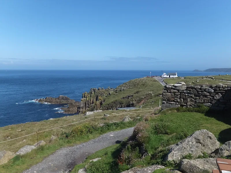
A very easy 1.6 mile walk between Lands End and Sennen Cove on the South West Coast Path
This is an easy walk along this magnificent coast line. A bus service links the two ends or it can be completed as a circular walk returning along the Cornish Way cycle track which runs parallel to the Coast Path . Looking out towards the9this is included in the Viewranger navigation) west and the Scilly Isles one may catch a glimpse of a spire or a dome or hear the muffled toll of bells from the fabled land of Arthurian legend that is known as Lyonesse and which disappeared beneath the waves.

Walk Statistics
- Start location: Lands End
- End location: Sennen Cove
- Distance: miles ( km)
- Total Gain: ft ( metre)
- Total Descent: ft ( metre)
- Min Height: ft ( metre)
- Max Height: ft ( metre)
- Est. Walk Time:
- Walk type: Linear
- Walk Grade: Easy
- Terrain: Footpaths throughout

Maps
The following maps and services can assist in navigating this route. There are links to printed maps and links to downloadable GPX route data for importing into navigational software and apps.
- Ordnance Survey Explorer Map
- OS Explorer 102 - Land's End
- GPX Route File
Accommodation
Mill Lane Camping and Caravan Park, PorthlevenView in OS Map | View in Google Map
- Website
- https://www.facebook.com/MillLaneCampsite/
- Description
- Mill Lane Camping and Caravan Park, Mill lane, Porthleven, Cornwall TR13 9LQ
Transport
First Group - Bus Service
- Service Details
- 300 - At the time of walking this route the local 300 bus service was provided by First Kernow and linked Penzance, Lands End, St Just, St Ives and Marazion. Due to the ever changing landscape of public transport it is advised to use the Traveline website to get the latest timetables and operators
- Timetable
- Traveline Website
Bus Service
- Service Details
- At the time of walking this route the local 2 bus service was provided by First Kernow and linked Penzance, Helston, Falmouth and Truro. Due to the ever changing landscape of public transport it is advised to use the Traveline website to get the latest timetables and operators
- Timetable
- Traveline Website
Walk Notes
The often quoted phrase of 'Rhubarb woke up and it was a soggy day' sprang to mind when daylight bought forth another Cornish day with the somewhat comforting pit pit patter sound of raindrops on the 'canvas' of the tent. The phrase harkens back from the days of youth and the old animation series of Rhubarb and Custard. It is very appropriate phrase for describing such grey and dismal mornings and encapsulates both the weather and doleful feelings all in one simple utterance. 'Rhubarb woke up and it was a soggy day'. The rain came down with a lingering persistence. Sometimes heavy, sometimes a patter but always unrelenting. A dribble. A drip. A pit-patter. I may have misquoted the phrase but it carries the general essence and is most definitely something the green dog character is likely to have said. It is very much a typical Rhubarb phrase. 'Rhubarb woke up and it was a soggy day and the soggy birds were blobbing about in the wet'. And the birds would be in their wellies and their rainhats and jumping up and down, splish sploshing in the puddles and liberally shouting twit to all and sundry.
Rain is not the best weather to be walking the South West Coast Path and when we eventually did rise the local radio weather forecast held little promise with expected rain for most of the day although clearer weather would spread from the west later in the day. Despite this there is always something to salvage from such a rain soaked day. No doubt Rhubarb would have decided to put on a show in the tent in aid of the soggy birds. Juggling. Dancing. Acting the Clown. A typical Rhubarb show. But this is where Rhubarb and The Griffmonster differ. I am not content to put on shows in tents for the birds when there are places to go and features to explore and despite the weather, where walking would turn into a miserable affair, there is always the bus provide the way and means to a days exploration.
This day was nearing the end of two weeks in Cornwall which had been a big let down with respect to the weather and the expected completion of the section of South West Coast Path from Plymouth to Land's End would not be accomplished. Therefore a venture to the end of the scheduled route would at least give a glimpse of what would be postponed until the next year. So, dressed in rain gear we set out on the bus from Porthleven to Penzance which connects with the service to Land's End. This is a tourist service that does a circular route from Penzance, out to Land's End then onto St Just and St Ives before returning via Marazion. The service is operated by old 1980's open top buses. It would take a brave individual to ride this service on the upper deck in the sort of weather that this day was dealing. A couple did venture up the steps but soon returned to the lower deck where the rest of us passengers sheltered. I am sure that during sunny days it would have been a glorious ride through the little lanes out to Lands End with sights to see and features to grab ones attention. However on this day we watched the scenery pass by from rain spattered windows, remarked at the water that issued down the stairs to the upper deck and intently looked for birds decked out in wellies and rainhats. They were not in great preponderance on this soggy day. I guess they were all back at the tent watching Rhubarbs juggling show.
Land's End. Even the name is iconic. It really is the end of England. An icon that is encapsulated in the British psyche. Somewhere everyone has to go to before they die just to say they have been there. Even hoards of foreign visitors make their way to this isolated location. It is only a rugged bit of coastline but for some reason it is the place to go. Maybe that is why it now hosts a theme park. Admittedly it isn't a vast emporium of screaming rides and loud unabashed fairground novelties but is nonetheless a theme park with interactive experiences based on several different themes. Maybe it was set up because the hoards of people who pilgrimage down to this remote spot were disappointed by seeing nothing but a rugged coastline. At least it gave them a sense of arrival and accomplishment. A journeys end. A shrine to touch. Something solid, a marker to say that this is indeed the legendary fabled land known as Land's End and their efforts to reach it were not in vain, but were something to celebrate and congratulate themselves as a token of achievement for the sacrifice of effort and time taken to reach it.
Personally I would rather have a wilderness devoid of structure other than the weathered granite. But that is my view and I am the sort of person who would rather venture out on buses than watch the Rhubarb juggling show so who am I to criticize this modern day temple in honour of the location. We wandered through the hallowed halls and walkways. Watched the few visitors have their photos taken under the mileage post where you can put a pointer to your home town and smile with the sea in the background, for a nominal price. Read the hoardings advertising the various attractions to try to understand exactly why it was here and not really getting it. Obviously this edifice was on a completely higher level of spiritual plain than the likes of my tiny mind. I just didn't get it! The sea. The rocks. The rugged landscape. The weather beaten hills. 20,000 leagues under the sea in 4D - that totally lost me. Why?
There was one redeeming feature of this visit to the Land's End Emporium of Discovery and Adventure. That was the arrival of clear blue skies and sunshine. Bright glorious golden sunshine. Warm and magnificent. This was both remarkable and unexpected. It had rained throughout the entire morning. It was predicted to rain throughout the afternoon. Then like some miraculous event the clouds did not just part or move on, they totally disappeared, bathing all visitors in a golden hue. That gave the impetus to meander along the coast path to Sennen Cove. It was only a short walk but at least it was a walk. An hours amble taking in the delights of the landscape. Then as the path led down into the village of Sennen Cove, the grey clouds returned. One minute blue skies and sunshine and the next grey dismal clouds. I guess the village rain enthusiast would have been jumping up and down in gleeful delight with the prospect of another visit to the village pluviometer to gauge the extent of the forthcoming precipitations. But for us two souls, we caught the next bus out of Sennen Cove, off on another adventure - braving the top deck, wind in our hair, rain in our eyes. I wonder if Rhubarb noticed the break in the clouds or whether the juggling show continued throughout the day unabated.
Directions
The South West Coast Path is well defined by the distinctive acorn logo waymarkers.
The bus stop is at the Lands End theme park. The coast path leads out from the coast side of the theme park through to Sennen Cove. The footpath/cycle track is a little further back close to where the bus stops.
Features
The LongshipsView in OS Map | View in Google Map
Just over a mile west of Lands End, protruding from the sea and visible from the mainland are a group of rocky islets collectively known as The Longships. Three of these are usually visible and are known as Tal-y-Maen, Carn Bras, and Meinek and others lie submerged. This have historically been a danger to shipping with many a vessel being caught out by their presence or driven onto the granite crags by storms. To assist navigation, in 1791 Trinity House gave a lease to Lieutenant Henry Smith to erect a lighthouse on Carn Bras, the largest of the Longship rocks. This three storied circular construction stood 24 metres above the sea, and held 18 parabolic metal reflectors. Even at this height high seas would obscure its beacon, so in 1869 Trinity House constructed a replacement granite tower which was finally completed in 1873.
This 35 metre tall building is still standing today providing one long five-second flash every ten seconds that can be seen for 15 natuial miles. The flashes are white when seen from seaward, but red sectors show if a vessel strays too close to either Cape Cornwall to the north or Gwennap Head to the south-southeast. The lighthouse was automated in 1988.
References
The Legendary Kingdom of LyonesseView in OS Map | View in Google Map
The kingdom of Lyonesse features in Arthurian legend and was said to b e the birthplace of Guinevere as well as the setting for the final battle between King Arthur and the traitor Mordred which resulted in both of them being killed. The kingdom was said to be an island that was located west of Land's End between the mainland and the Scilly isles. It was a fertile and prosperous land made up of 140 villages and churches and the beautiful City of Lions which held whart some called a great cathedral and others say was a magnificent castle.
Lyponesse's second king was Meliodas whose son and heir was Sir Tristan, a knight of the round table from Arthurian legend. After King Meliodes had died a great catastrophe struck the island with the sea flooding across the entire land, drowning the villagers and swallowing the entire kingdom in one fateful night. At the time Tristan was attending his uncles court in Cornwall and as a result was never able to take up his inheritance. Not all the islanders perished in the great inundation of Lyonesse. A man named Trevilian foresaw the impending disaster in a dream and on waking he leapt on his white horse and sought sanctuary in a cave in Marazion. Even to this very day the Trevilion coat of arms bears a horse emerging from the water. Another survivor was the Lord of Goonhily who managed to land at Sennen Cove where he founded a chapel in thanks for his deliverance. This was Chapel Idne and was located on the site of the present day car park.
There is much debate whether the island actually existed and whether its location was off of the Cornish Coast. It is known that during Roman times the Scilly isles were a single island which indicates that sea levels have significantly increased over time with large tracts of coastline being immersed by the waters. Many texts point to an extract in The Saxon Chronicles which refer to a the sea-flood which 'sprung up to such a height as no man remembered' in order to substantiate the sinking of Lyonesse. This occurred in the year of 1099 on the festival of St Martin, which is attributed to the 11th of November but there is no actual mention of the land in the text.
Whether the island existed or not the legends are firmly instilled in local folklore. The Cornish language name for Lyonesse is Lethowsow which refers to the Seven Stones reef some 15 miles west of the mainland, a notorious area that has claimed many shipwrecks including the Torrey Canyon. It is said that this was the location of the great City of Lions whose remains can still be glimpsed beneath the waters on a calm day, remnants of which are sometimes brought up in the trawlernets of local fishermen. Tradition claims that during storms and rough seas you can hear the bells of the drowned city tolling from beneath the waves.
References
Image Gallery


Route Validation Cards
Validation Date - 2012-07-04
- Time of Walk: 12:30 to 13:30
- Validators: Griffmonster, Kat
- Weather Conditions: Warm and sunny with plenty of sunshine but windy. Either side of this hour was grey with frequent heavy showers
- Notes: Initial route undertaken
Summary of Document Changes
Last Updated: 2026-04-20
- 2013-12-15 : adjust incorrect direction information
- 2016-01-15 : General website updates
- 2019-01-07 : General website updates
- 2021-03-17 : Update website improvements and removal of ViewRanger reliance
- 2021-12-01 : Removal of ViewRanger links due to its imminent demise
- 2026-01-12 : Major website update with all walks recast to the new format


0 comments:
Post a Comment