Rushden Skew Bridge Lake Walk
Tuesday, 26 February 2019
|
No comments
|
![]()
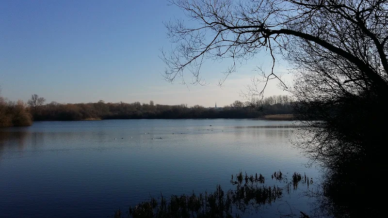
Short circular walk around the Skew Bridge Ski Lake
A very simple and easy walk along the footpaths around Skew Bridge Ski Lake. Situated on the edge of the Rushden Lakes shopping complex with restaurants and decking facing onto the lake, this trail circumnavigates the waters through the woodland that surrounds it. Wood based sculptures of a plethora of creatures can be found throughout. Any visitor to Rushden Lakes should take the opportunity to wander this trail.

Walk Statistics
- Start location: Rushden Lakes
- Distance: miles ( km)
- Total Gain: ft ( metre)
- Total Descent: ft ( metre)
- Min Height: ft ( metre)
- Max Height: ft ( metre)
- Est. Walk Time:
- Walk type: Circular
- Walk Grade: easy
- Terrain: Well maintained track
- Obstacles:

Maps
The following maps and services can assist in navigating this route. There are links to printed maps and links to downloadable GPX route data for importing into navigational software and apps.
- Ordnance Survey Explorer Map
- OS Explorer 224 - Corby, Kettering & Wellingborough
- GPX Route File
Accommodation
Rushden (Wellingborough) TravelodgeRoomView in OS Map | View in Google Map
- Website
- https://www.travelodge.co.uk/hotels/190/Wellingborough-Rushden-hotel
- Description
- Basic but comfortable rooms. Adjacent to Rushden Lakes.
Walk Notes
The Rushden Lakes Shopping complex was started construction in 2016, eventually opening in 2018. The site occupies the land of a former gravel works which processed gravel and sand extracted from the adjacent Nene valley. Decades of extraction resulted in a series of pits which filled with water to form a series of lakes along the valley, all the way through to Stanwick. Once the extraction was completed the area was left to nature with native trees growing up around the borders and wildlife taking over the landscape. With the coming of the Lakes centre, the whole area has become a managed nature reserve with addition of footpaths, nature trails and features that blend in with the landscape creating accessible walks full of natural diversity of wildlife, flora and fauna. The valley area has now been designated a Site of Special Scientific Interest and is popular with both locals and visitors alike.
This specific walk is a simple excursion from the shopping area which employs the Skew Bridge Ski lake as a natural centre piece with restaurants looking out across the lake. All who visit this temple dedicate to the Gods of Consummerism should take the time out to enjoy this wander and experience a little bit of nature. For myself, visiting the area after some 20 years, this was more of a trip into the past, an inspection of old haunts in this dramatically altered landscape. I had grown up knowing the Gravel works. The dual carriageway had yet to be constructed and there was little around other than fields, with views across the valley with the hamlet of Ditchford at the bottom where the Chettles Abattoir company occupied a site by the medieval bridge and would issue awful smells that would waft through to Rushden, much to the annoyance of the general population.
The Skew Bridge Ski Club was a icon of its time and the destination for many 80s party events. A dry ski slope was a recognised landmark and stood in front of the lake, approximately where the shops now reside, Mountain Warehouse appropriately being the suspected position of the ski slope.
Going further back in time, during the years of being a young teenager, the Ski Club was the last destination on a paper round. This was an addition to my regular round where two of us lads would take on the others round when one was on holiday. Therefore, it was usually during the summer that I headed, early morning in the fresh air, down to the ski club, chasing the rabbits that would dart in all directions away from the track that led under a railway arch and down to the clubhouse. Great days.
With all this change about, this revisit to the area provoked a little research. Throughout my time of growing up in Rushden, the railway bridge that traversed the old A45 road at an angle was always referred to as the Skew Bridge. However, research shows that this is most certainly an incorrect assumption. The main article to this walk below details the research and shows quite clearly that the Skew Bridge dates back way before the railway even existed. Take the walk. Enjoy the nature. Then, read on.
Directions
Simple walk around the Skew Bridge Ski Lake
The walk starts and ends at the decking by the Wildlife Trust Visitor Centre that looks out from the shopping complex across the lake. The walk is waymarked and is a simple circular route following the edge of the lake. One cannot get lost.
Features
Skew BridgeView in OS Map | View in Google Map
The Rushden Lakes shopping centre covers an area adjacent to an area of the Nene valley that was used for gravel and sand extraction from the 1950s through to the late 20th century. The result was a vast area of lakes of varying sizes. The main lake that fronts the shopping centre is the Skew Bridge Ski Lake. The name holds its place in the history of the area.
Prior to the construction of the highway that now takes traffic past both Rushden and Higham, the main A45 trunk road was no more than a single carriageway that led from the junction into Rushden, locally known as Sanders lodge, through to the centre of Higham Ferrers with nothing but fields on either side. Not far from the junction, as the road dipped down the hill from Sanders Lodge it passed under a railway arch that was skewed against the course of the road. A Skew Bridge. For many who grew up in Rushden this was the Skew Bridge but the name goes much further back than the railway bridge.

If one studies the old 19th century Ordnance Survey maps, the name of Skew Bridge is clearly depicted, not against the railway but further down the road as it crosses Rushden Brook (see map below). The 1884 OS map (above) which was produced prior to the railway also annotates Skew Bridge across the brook. Even on modern maps, the annotation for Skew Bridge does not coincide with the railway which is now largely gone due to the substantial development that has been undertaken in the area. This certainly points to the Skew Bridge being a river bridge rather than a railway bridge, despite what many local folk assumed.
Rushden Brook is a humble water course that flows from Bedford road, through the town to outfall into the River Nene. Commonly known by many old residents of the town as simply Rushden Brook, it was originally known as Sidney Brook. The name derivation is unclear although it may have been taken from a field name at its source, Sid Meadow. The road bridge over this was said to skew its course with a hump-backed bridge to get across the water. Such a skew is not depicted on any of the OS maps and the course of the road does not indicate a hump back bridge, therefore this must date back prior to the mid 19th century.
These days with the modern roads and the massive amount of development around the area the brook has become almost invisible to any passers by. But look closely and it is still there, lurking in the landscape, anonymously hidden away at the road junction between the Needle and Awl pub and Waitrose supermarket. The humble Sidney Brook passes under the junction with no ceremony or recognition. This surely must be the modern day Skew Bridge.

The fact that the river bridge was the original location of Skew Bridge is a bit of a revelation, even to many bought up in the town during the 1960s and70s. Skew Bridge in those days was always linked to the railway bridge. This was the same for the previous generation and, as far as I know, the generation before. However going back to the early 20th century the name is certainly in use to refer to the river bridge, as demonstrated in the notes of Joseph Enos Smith who was born in Stanwick in 1851. During his later years, J E Smith started to accumulate notes from various local sources, the collected works of which are now deposited in the Northamptonshire Record Office. It is in one of these notes from 1916 where he makes a clear distinction between the two bridges on Northampton Road (emphasis added).
From the latter place [Sanders Lodge], under the Midland Railway, over ‘Skew Brig’ and ‘Sidney Brook’ to Higham Ferrers is the Wellingborough-Kimbolton Turnpike.
This certainly makes the distinction that the Skew Bridge is beyond the railway bridge.
The Skew Bridge Ski Club was formed in the early 1950s after its founder, John Wills, wanted a body of water to practice water skiing upon. The lake that had been formed from gravel and sand extraction provided a perfect resource. Starting with a membership of just six he built up a club alongside the lake with a Nissen hut as a clubhouse. A spur from the railway line came off alongside the ski club, culminating in a dead end. This had originally been proposed to make a connection with the Northampton to Peterborough railway at Ditchford but the line was never completed resulting in this huge embankment that stopped before the lake. During the 1960s this mound was re-purposed as a dry ski slope, cutting away the embankment between the end of the spur and its link with the railway line. A brick clubhouse was also added which became the destination for many looking for entertainment at the weekend during the 1970s and 80s.
The location of the Ski Club was directly in front of the lake where the present day shopping centre exists, and access from the main road was via a track that cut through the railway embankment by an established bridge. This was to the west of a spur from the railway line that is clearly depicted on old OS maps.

During a 2011 interview for Rushden and District History Society John Wills divulges the origins of the name of the Skew Bridge Ski Club. He states in no uncertain terms that the name of the club was chosen not from the railway bridge but from the river bridge:
Then we had to decide on a name. There used to be a hump-backed bridge along where the A45 is now called Skew Bridge in the Domesday Book so I thought we’d call it Skew Bridge.
It is dubious that this was recorded in the Domesday Book, online records for both Higham and Rushden recording no such bridge. The fact is Mr Wills, whatever his original source, makes the clear distinction that the Skew Bridge is the not the railway bridge, much to the interviewers surprise.
References
Image Gallery


Route Validation Cards
Validation Date - 2019-02-17
- Time of Walk: 10:00 to 10:30
- Validators: Griffmonster, Kat
- Weather Conditions: Clear blue skies
- Notes: Initial route undertaken
Summary of Document Changes
Last Updated: 2026-04-20
- 2019-02-26 : Original publication
- 2021-03-17 : Update website improvements and removal of ViewRanger reliance
- 2021-12-01 : Removal of ViewRanger links due to its imminent demise
- 2026-01-12 : Major website update with all walks recast to the new format


0 comments:
Post a Comment