Leiston to Walberswick Circular Walk
Tuesday, 1 January 2019
|
No comments
|
![]()
A 22 mile circular walk between Leiston and Walberswick incorporating sections of the Suffolk Coast Path and Sandlings Walk.
This walk uses the beach at low tide to get from Sizewell to Walberswick, returning through Dunwich forest. Walberswick is said to be the most haunted place in Britain though one would not think it from its relaxed and laid back character, famous for its crabbing pastimes.

Walk Statistics
- Start location: Leiston
- Distance: miles ( km)
- Total Gain: ft ( metre)
- Total Descent: ft ( metre)
- Min Height: ft ( metre)
- Max Height: ft ( metre)
- Est. Walk Time:
- Walk type: Circular
- Walk Grade: Lengthy but all level walking
- Terrain:

Maps
The following maps and services can assist in navigating this route. There are links to printed maps and links to downloadable GPX route data for importing into navigational software and apps.
- Ordnance Survey Explorer Map
- OS Explorer 212 - Woodbridge & Saxmundham
- GPX Route File
Walk Notes
This is an extensive full days walk and should only be undertaken by those who are fit and used to walking such distances. The route takes advantage of both the Sufffolk Coast Path and The Sandlings Path and offers a variety of scenery including beach, forest and sandlings heath.
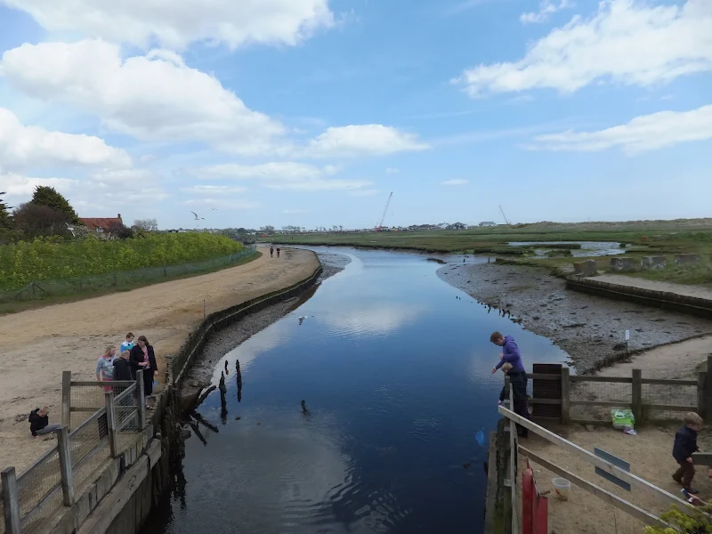
The walk needs to be planned with reference to the tide times. Two to three hours either side of low tide reveals enough firm sand to complete the distance from Sizewell to Walberswick. Outside of these times it is shingle which can take a lot more effort to achieve the whole distance from Sizewell to Walberswick. The alternative is to walk the dunes through to Dunwich Heath and then follow the Suffolk Coast Path waymarkers.
The shingle ridge between Walberswick and Dunwich acts as a defence to the marshes around the Dunwich river. Up until 2006 this defence was maintained by the Environment Agency, with frequent breaches being their responsibility to repair. However in more recent years the Agency have retreated from their position as maintainer and has proposed that the sea should be allowed to break through the shingle ridge to allow the area behind to become salt marsh. This has caused concern from the people of Walberswick who feel the impact upon the village and surrounding houses as under the EA proposal the Old Town Marshes, Corporation Marshes, Town Salts, Town Marshes will all be lost to the sea and the Walberswick shoreline will eventually retreat to the sea wall erected following the great 1953 flood.
This neglect of the defences can now be seen with part of the shingle ridge completely breached with the high tide mark clearly visible along the highest point of the remaining shingle and a large portion of shingle washed over onto the marsh. This must mean that any significant high tide results in the water cascading over into the marshes with the route impassable to beach walkers. With North Minsmere also being allowed to be breached this section of coastline between the Blyth and Alde estuaries will undoubtedly drastically change over the next few decades. One would have thought the integrity of this coastline would be a high priority considering that a Nuclear Power Station sits midway between the two estuaries. I guess economics outweigh safety these days.
Directions
The walk follows the coast from Sizewell to Walberswick and returns through Dunwich forest along the Sandlings route.
Leiston to Sizewell
Head down Red House Lane toward the Leisure Centre. Continue into the lane at the end until it crosses the former railway by the farm cottage. Proceed straight ahead across the fields toward Halfway Cottages. Turn left to walk down the side of the cottage and onto the road. Turn right and keep walking down the road to Sizewell.
Sizewell to Walberswick
The Suffolk Coast Path official route heads along the dunes to Dunwich Heath and then inland, but in this instance, stick to the shoreline all the way through to Walberswick. There is usually firm sand either side of low tide, and often more expansive amount of sand after stormy conditions
Walberswick to Leiston
Follow the road out of the village, bearing to the left as it junctions. This lane follows the northern edge to the marshes and is joined by the Sandlings Path. The lane deteriorates into a sandy track which continues through to Five Finger Post junction with the Westleton to Blythburgh road. At this point, the Sandlings doubles back on itself and follows alongside the Dunwich road before crossing it. Keep to this route, following the Sandlings waymarkers through the woods. Eventually the path descends down a bank past Potton Hall, then through grassed fields and back up to more woods. When the path turns a sharp left, continue straight ahead on a footpath by the side of a cleared piece of woodland. Keep to this until it meets Westleton Heath where a track passes across the route. Veer left onto the track and continue until it emerges onto the road. Go straight ahead along the road opposite and continue along this until it bears sharp right, with a left turn down to Minsmere. Go straight ahead onto a track into the woods and keep to this until it emerges onto the road into Eastbridge. Follow the road straight through the village and onto the junction with the Leiston Road. Turn left and follow the pavement down into Leiston.
Pubs
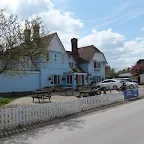
The Anchor, Walberswick View in OS Map | View in Google Map
- Address
- The Anchor, Walberswick
- Website
- https://www.anchoratwalberswick.com/
The original building that stood on the site of this pub was known as The Blue Anchor and dates back to at least 1787 when it was recorded that Thomas Maggs took the inn over. In those days, like many pubs and inns along this coast, it had a reputation as a haunt of smugglers. When the old building was demolished in the 1920s, workmen found a bricked-up doorway in the remains of the cellar. This was said to be the entrance to a tunnel that led to the beach. Further discoveries were made when the present building was erected, when more traces of the tunnel were discovered.
Today the pub is known as The Anchor Inn, though it sports a sky blue paintwork reflecting its former name. Inside there are three rooms with wood panelling and a 50 seater restaurant and the pub prides itself on its innovative food and wine selections. There are occasional beer festivals and the pub is walker and dog friendly.
This was the first visit to the Anchor for some years. I was hoping they would have some guest ales but unfortunately it was only Adnams, with the simple choice of Bitter or Broadside. The Bitter was certainly refreshing after the long hike up the beach.
The Bell Inn, Walberswick View in OS Map | View in Google Map
- Address
- Ferry Road, Walberswick
- Website
- https://bellinnwalberswick.co.uk/
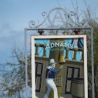
This 600 year old pub still retains the original worn flagstones on its bar floor. There is lots of charm and character about this historic building full of wonky steps, ill fitting door and oak beams and numerous intimate rooms with numerous photos and artifacts decorating the uneven walls. A good selection of Adnams ales is on offer with snack, sandwiches and the usual pub food on offer. Large grassed garden area and children and dogs are welcome.
It is said that a ghost of a fisherman can sometimes be seen sitting in the smoking room. There was also a tunnel that led to the old vicarage near the ferry, part of which was discovered when building work was being carried out.
This pub is everything one expects from an typical old English village pub. Full of nooks, crannies, wonky walls and ill fitting and worn doors, flag stone floors, old photos, posters and always something new to feast ones eyes upon. They had a good range of Adnams ales on offer. I went for the Ghost Ship and Kat had the Sole Star, both first class along with the sandwiches.
The pub is currently managed by a team which also manage the Harbour Inn on the opposite side of the River Blyth at Southwold. On each table there sat a business card which advertised the Bell on one side and the Harbour Inn on the reverse. The strap line to the Harbour Inn read 'Located by (and sometimes in) the river Blyth'. Humorous but oh so true.
Eastbridge Eels Foot View in OS Map | View in Google Map

- Address
- Eastbridge Eels Foot
- Website
- https://www.theeelsfootinn.co.uk/
A curious name for a pub; some say it comes from a Heel's Foot, a cobblers implement, others will argue that it is named after the Eel's Boot, a type of woven reed basket used in Eel Fishing. A more fanciful explanation is that it is a derivation of Neale's Boot, named after a medieval priest who trapped the Devil in his boot and tossed him into the river. The Devil escaped disguised as an eel.
The pub is an Adnams establishment and regularly has at least three of their cask ales on tap, with the Bitter and Broadside plus seasonal ales. The pub is popular with walkers and birdwatchers from nearby Minsmere bird Reserve.
Food and Bed and Breakfast accommodation is on offer and The Eels Foot is renowned for its long tradition of Folk Music which still continue on Thursday evenings with a jam session.
Up until late 2014 the wall in the alcove adjacent to the bar was decorated with a curious painting of a medieval country feast. On a casual glance it was nothing more than an insight into times gone by but on closer inspection would could see that some of the men within it were wearing rather large codpieces. The painting appeared to be a corruption of 'The Peasants Wedding Feast' by Pieter Bruegel. His son, Pieter the Younger, would copy his fathers work and this particular article could have been a humorous copy as the original has a completely different background and no cod-pieces. Unfortunately this has now been removed, which, so I am told, caused some controversy.
The first Explorer of the year was on offer here. Accompanied by a glass of water to quench the thirst, this cleaned the palate and the crisp zesty hops were so much more pronounced after this. The fireplace was being reconstructed, though I am not certain what is being done. Maybe they are opening it up to a full inglenook which would be good.
Features
WalberswickView in OS Map | View in Google Map
Once upon a time Walberswick was the lower ranked port to Dunwich. In those days the River Blyth snaked southwards changing its name to the Dunwich River before flowing out to the North Sea at Dunwich. The men of Dunwich charged a toll on any goods bound for Walberswick and this produced a lot of animosity between the people of Walberswick and Dunwich, resulting in regular incursions and conflicts. The tolls were ended by Henry IV in 1408 when an enquiry concluded that Dunwich had no right to charge the tolls. Walberswicks fortunes increased when storms silted up the river at Dunwich and a new channel was cut directly out to sea at Walberswick. The town thrived on the trade and had a fleet of ships trading with Europe. The village became prosperous and two churches were built. Sadly this prosperity failed to last as the river silted up and was unable to take the increasing size of more modern ships. As the prosperity dwindled the town became no more than a simple fishing village. One of the churches was demolished in 1473 and the second, and remaining church of St Andrews, rebuilt in 1695 within the confines of its original structure.
Village Sign
The village sign was designed by Clifford Russell, an architect and artist who lived in the village, to commemorate the Coronation of Queen Elizabeth in 1953. The sign depicts a 17th century Man-of-War to represent the ship building heritage of the village and was originally placed at the entrance to the village. Unfortunately the sign was stolen in 1984 and the present sign, which was copied from a photo of the original and is two third the size, was placed on the village green for safer keeping.
Recently, the original sign has resurfaced following an unusual discovery by a couple from Kent. They discovered the ironwork at a second-hand garage sale and had purchased it purely on its decorative merits, not knowing that the name of Walberswick was a real village. Then, by chance the couple took a holiday in Norfolk and on driving up the A12 had noticed the village of Walberswick signposted at Blythburgh. On their return home they contacted the village through its website and donated the sign back to its original home. After undergoing renovation it was officially put back into position on 3rd June 2012.
Ghostly Tales
It is claimed by some that the village of Walberswick is the most haunted place in the country. Although this may be disputed by many other towns and villages, there are a host of spooky tales about the place, including accounts right up to the modern day.
Like many Norfolk and Suffolk coastal towns, Walberswick has its Black Shuck legends. Black Shuck is a ghostly black dog, huge in size and usually with fiery red eyes and a portender of death to anyone who may have the misfortune to witness the beast. His first mention in Walberswick dates back to 1577 when an appearance was recorded in a church pamphlet, reporting that the phantom hound haunts the road between the vicarage and the Bell pub. A more detailed account comes from the winter of 1940. This particular night was cold and a thick layer of snow lay on the ground. An American couple had rented out a wooden hut close to Walberswick marsh and were coping as best as they could through the cold evening when the heard an almighty banging on the front door of the hut. The sound continued and they hurried to look out the window to find out what was making the commotion. The sight they witnessed was something they certainly were not contemplating for there, forcefully throwing itself against the door was a terrifying black dog with glowing red eyes. The sight made them rapidly draw away from the window and as their hearts paced they heard the hound leap onto the roof. Their fears soon abated because no sooner than it had got onto the roof, than it leaped off and ran away leaving just the sound of the cold wind wrapping around the timbers. Eventually, the couple plucked up the courage to investigate outside and was shocked to find, despite all the activity, there was no disturbance or paw-prints left in the snow.
There are numerous other tales of encounters with this beast around Walberswick, the more recent coming from the 1980's when two women reported seeing a phantom dog as big as a calf. Maybe others have come across this beast in more recent years but have not gone public with their sightings.
Another ghostly encounter is that of a young boy and old man who are seen waiting at the ferry landing pier. Although the ferry picks them up, they disappear in a ghostly fog before they reach the other side. It is said that they are the ghostly forms of the two individuals who drowned whilst making the ferry crossing some 200 years ago.
When George Orwell visited the village in the 1930's he encountered a spectre in the churchyard. This apparition was said to be a small and stooping figure dressed as a workman who silently walks across the churchyard and disappears. This figure has since been seen by numerous others.
And it is not just ghostly sightings that abound in the village, it is claimed that if you listen hard enough you may hear the high pitched sound that is locally known as the Walberswick Whistle. No-one really knows where the noise emanates from though legend says it issues from the holes in the ground around Walberswick and is the scream of a long lost woman who ventured into the caverns below the ground never to return. Whatever its source, it frequently scares animals.
Lastly, as the walk heads out of Walberswick and joins the Sandlings Path, just before the lane turns to a track, on the right is an old extensive manor house known as Westwood Lodge, this was the home of John Brooke who was a bit of a tyrant in the 17th century who is still supposed to haunt the building. More can be read about this ghostly story on The Blyth Valley Walk. It may be speculation, but local stories tell of a phantom horseman that rides this area, and maybe this could be John Brook himself who used to terrorize the area on his horse. I would have put this down to old smugglers tales to ward off prying eyes had it not been for a friend who told me their father had an encounter with this ghostly form on the road between Westleton and Blythburgh. I regularly travel this road but the only things that have leaped out in front of me thus far are pheasants and deer and they are always very much real! I keep my eyes open for the ghostly horseman.
Walberswick FerryView in OS Map | View in Google Map
It has been stated that there has been a ferry at Walberswick from the 13th century onwards. There is certainly pictorial and documented evidence of the ferry from the nineteenth century when the Cross family worked the ferry. As the century drew to an end a chain ferry became established. This was initially a hand-cranked ferry but was later replaced by a steam ferry. The chain ferry service operated up until the second world war when the local landowner Sir Ralph Blois refused to renew the lease. It was then that Old Bob Cross set up a rowing service which passed passed down to his son, Young Bob and then to Young Bobs nephew David Church and finally to Dani Church who is the present oarswoman.
These safety conscious days the ferry is forced to provide life jackets and issue warnings of 'Keep your hands on deck' as the ferry approaches the landing stage. Nonetheless it is always a pleasant experience to cross the Blyth on this friendly ferry service. As a tribute to her dad, Dani Church wrote a book containing a collection of stories and the history of the ferry. This is available through Amazon.
References
Links and Bibliography:
Image Gallery


Route Validation Cards
Validation Date - 2012-05-13
- Time of Walk: 09:00 to 18:30
- Validators: Griffmonster, Kat
- Weather Conditions: Sunny day with cloud steadily increasing throughout the day
- Notes: Initial route undertaken
Summary of Document Changes
Last Updated: 2026-04-20
- 2012-05-30 : Initial Publication
- 2016-01-16 : add in report that the village sign has now been reinstated, plus a link to the news story
- 2018-12-30 : General website updates and rework notes
- 2021-03-17 : Update website improvements and removal of ViewRanger reliance
- 2021-12-01 : Removal of ViewRanger links due to its imminent demise
- 2026-01-12 : Major website update with all walks recast to the new format


0 comments:
Post a Comment