Suffolk Coast Path - Lowestoft to Southwold Inland Route
Sunday, 30 December 2018
|
No comments
|
![]()

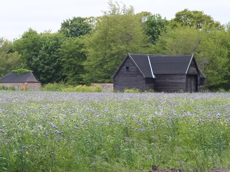
A 17 mile walk using the official inland route of the Suffolk Coast Path from Lowestoft to Southwold
Due to erosion and tides the Suffolk Coast Path takes an inland diversion for the section between Lowestoft and Southwold. Although the alternative beach route can be accessed providing the tides are right, this route nonetheless has its worth especially for the picturesque section around Frostenden.

Walk Statistics
- Start location: Lowestoft
- End location: Southwold
- Distance: miles ( km)
- Total Gain: ft ( metre)
- Total Descent: ft ( metre)
- Min Height: ft ( metre)
- Max Height: ft ( metre)
- Est. Walk Time:
- Walk type: Linear
- Walk Grade: Easy walking
- Terrain: Tracks, country lanes and some road walking between Lowestoft and Kessingland
- Obstacles: The section from Pakefield to Kessingland involves walking alongside the main A12 trunk road. There is a pavement but caution should be taken along this busy route.

Maps
The following maps and services can assist in navigating this route. There are links to printed maps and links to downloadable GPX route data for importing into navigational software and apps.
- Ordnance Survey Explorer Map
- OS Explorer OL40 - The Broads
- Ordnance Survey Explorer Map
- OS Explorer 231 - Southwold & Bungay
- GPX Route File
Transport
First Group - Bus Service
- Service Details
- 99 - First Group 99 bus services connecting Southwold, Kessingland and Lowestoft.
- Timetable
- First Group Suffolk and Norfolk Website
Walk Notes
A Water Tower Enthusiasts Ideal Walk
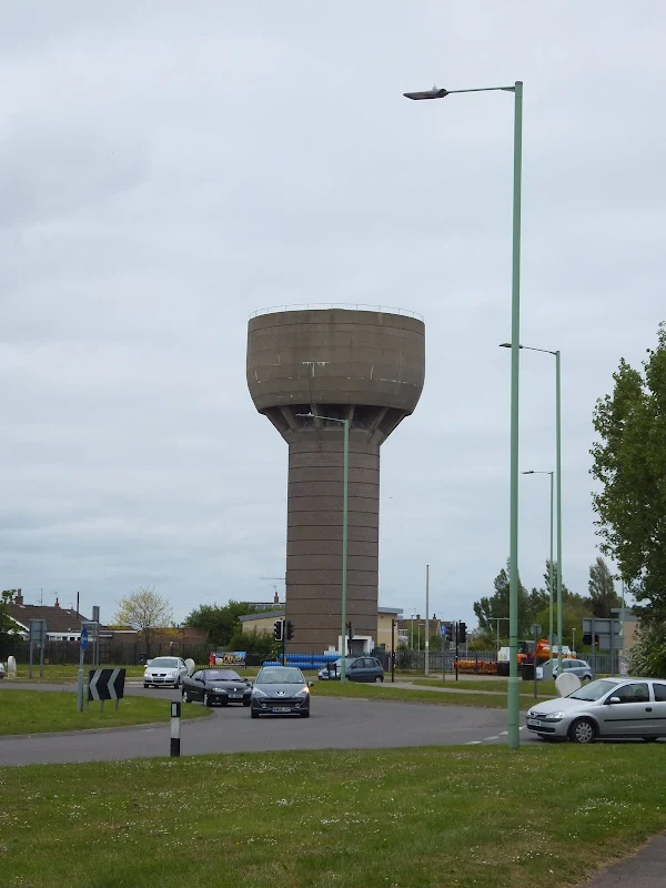
Walking down the promenade from Lowestoft and then onto Pakefield, the beach is such an enticing way onward to Kessingland. Indeed, this section of beach is an easy walk and is accessible most of the time, even at high tide. However there are occasions when spring tides or storm surges may prevent access and at such times the route described here provides an alternative method of getting to Kessingland and through to Southwold. This is the official route of the Suffolk Coast Path as as such it is way-marked with he distinctive blue and yellow markers. The section from Pakefield to Kessingland is probably is not the most scenic of walks, with a considerable amount of road walking, including a section along the pavement beside the main A12 trunk road where the only passing feature is the Pakefield Water Tower.
Standing at the northerly side of the A12 Pakefield roundabout, this concrete construction was built in 1959 though little other information is available about it. There is another Pakefield water tower dating from 1935 which is on Stradbroke Road, just off the roundabout. In fact this walk could become a Water Tower Enthusiasts ideal ramble with another Water Tower a little off-route at Kessingland, and another off-route at Benacre and finally two classic examples at Southwold. The Southwold towers are notable as the Wikipedia article on Southwold states: 'The Old Water Tower, in the middle of Southwold Common, was built in 1890. The tank held 40,000 gallons of water and was powered by huge sails. On St Valentine's Day 1899 George Neller, a respected local man, died when his coat got caught in its machinery. In 1937 a new 150,000 gallon capacity Art Deco water tower was built next door. The then Southwold Borough Council bought the Old Water Tower before it came into the hands of successive water companies. It was returned to the Town Council for a nominal fee of £100 in 1987. The Old Water Tower has since been used as the Lifeboat museum and was later used by Adnams for a number of years.'
Although it is not compulsory to be a budding water tower spotter, these landmarks add a little interest to this walk. There is even a British Water Tower Appreciation Society who describe themselves as 'the only British society dedicated to water tower culture and history' and whose blog is an interesting read with lots of information and images about water towers throughout the UK as well as a link to The German International Water Tower Society for those who want to investigate Water Towers further afield.
A strange find upon the beach
I have been following Christian Nock's epic fund-raising walk around the coast of Britain and it was on the section between Southwold and Lowestoft that he encountered an odd brick structure on the beach at Benacre. This was only a few weeks before we planned to walk this section and I was intrigued by exactly where this construction was located. I have walked the beach route many times and never encountered anything like the domed circular construction which Christian had photographed on his travels. He had labelled this as Benacre Broad but was not more precise.
Therefore, just south of Kessingland where when the Coast Path briefly meets the beach prior to heading inland around the Benacre broad I took a step down onto the beach to see if there was any sign of this brick building and was surprised to find it was at this very point. Standing proud of the shingle this 8 foot brick construction was a real curious oddity. The bricks were not matched tight against each other with gaps throughout the walls of its circular base as if it had been built in a hurry by someone who was not a competent brickie. The top was roofed with a bricked dome that had partially fallen in. It was such a curious oddity and certainly something one could not miss when walking the beach, even if the tide was high.
Despite many searches on the web there appeared to be little information about this strange folly. Eventually an article appeared in the Lowestoft Journal which claimed that it was an old cesspit that had been revealed by recent erosion. It is true that the winter rain and floods resulted in significant erosion at this point as the flood waters drained into the sea at Benacre sluice. This had cut out a huge chunk of coastline to the north of the sluice. Despite this knowledge it is hard to believe that this cesspit was buried in the shingle as its height would surely have revealed it. I can only think that it had shifted its position but it looked so fragile. Having said this, it is located well below the tideline and must be taking a constant battering by the tides and has so far stood up to this punishment so who knows, maybe it was further down the beach and the tide has revealed it and pushed it up the shoreline.
More recently, in April 2016, a similar structure was revealed when erosion took away the shingle in front of Orfordness Lighthouse. This was topped with a manhole cover and could well be a cesspit. A picture of this can be seen of the Aldeburgh Coastguard's Facebook page.
It must be stressed that that at this point the beach route looks tempting to continue down to Southwold. Be aware that this is inaccessible at high tide and tide times should be consulted before attemping to walk further south.
Alternative Route
The path heads around Benacre Broad and on towards Coverhithe where walking a little extra towards the cliffs will result in viewing the magnificent ruin of Covehithe church. This is well worth the additional effort if not seen before, but for those who wish to disregard this feature then a short cut can be made by heading along the track between the two roads into Covehithe.
Another alternative is at Reydon where the official route heads down the the beach on the north side of Southwold. Continuing along the road through Reydon and then on the main road into Southwold is a shorter option, especially if the free car park on the green is made use of.
This walk could also be undertaken as two circular walks using the beach as the return section in each case - one from Southwold to Covehithe and then secondly between Lowestoft and Covehithe. This gives the best of both the beach route and the inland route and has the advantage of allowing for the tide by walking the inland route when the tide is high.
In all honesty I do prefer the beach route throughout and this is documented on the Suffolk Coast Path - Lowestoft to Southwold Beach Route. However to walk the entire route along the beach requires both good timing and the tides to be right and in most cases a mix between this route and the Suffolk Coast Path - Lowestoft to Southwold Beach Route would need to be planned.
Directions
The Suffolk Coast Path is well defined with distinctive blue and yellow way-markers conveniently located throughout the entire route. The alternative beach route is not way-marked.
Take the promenade southwards out of Lowestoft through to Pakefield where it continues along the top of the cliffs. Keep to the cliff top south of the church until it meets with a lane by a house made from a converted railway carriage together with an old railway yellow and black signal in its garden. Tuirn right down this lane keeping straight ahead when the road sharply turns left. This emerges at the Pakefield roundabout on the A12. Turn left and follow the pavement alongside the main road until it meets the next roundabout. Keep to the pavement as it runs alongside the road into Kessingland. Just beyond some houses on the right the path takes a track on the left which is the Heathland Beach Caravan Park. Before it reaches the Caravan Park, there is a footpath that continues alongside the road on the right then turns by a copse of trees and heads over the fields until it meets another footpath. Turn left and follow this path down towards the cliffs. The path turns to a track and leads into Kessingland. Take a path on the left which leads to some steps onto the promenade. Keep to this until it meets the road. The Sailors Home pub is on the right.
Keep to the promenade out of KEssingland. This leads onto the dunes and towards the pumping station on the River Hundred. The path goes between the pumping station and the sluice to the beach. Kepp on the track that leads around the inland side of the broad. This returns back to the beach at which point a track leads off inland. Take this and when it meets a road, turn left. Follow the road through to a sharp right hand bend at Wood Farm. Take the track on the left until it meets a road. Turn left and follow the road through to Coverhithe. The roads forks with another which is the route to continue along but it is worthwhile having a look at Covehithe church is a little further along the road.
Return back up the road from the church and take the left fork as it heads out of Covehithe. Keep to this road through to the junction with the B1127. Turn left. This is a busy road but there is a broad grass verge on the right hand side which can be walked along. Take the first junction on the right, opposite the church, and follow this lane, keeping to it as it bends around to the left where another lane junctions with it. AS the lane enters more woodland on the left keep a lookout for a footpath sign. Take this through the woods and follow it as it veers around to the right and out onto meadowland. The path is well trodden across the meadow and leads out onto a tarmac-ed lane. Turn left and follow this onto a track and keep to this when it bends sharply round to the left ignoring other routes. The track turns to a small footpath which, after some distance, nearly doubles back on itself, Continue until there is a footpath on the left just before the overhead power lines are reach. Take this path through to the road. Turn left. Keep to this little used lane, ignoring other lanes until it emerges into Reydon. Continue straight ahead through Reydon and ahead again when the road meets with a forked junction. Continue down to the junction with the Southwold road. Turn left and follow the road over the Buss Creek bridge and up into Southwold.
Pubs
Sailors Home, Kessingland View in OS Map | View in Google Map

- Address
- Church Road, Kessingland
This brick building facing the beach dates from the mid 19th century when records show it became a pub some years after the building had been constructed. It suffered a serious fire in 2007 but has more recently been restored. It features a large and welcoming bar offering pub food and a variety of ales.
A good selection of ales from both local brewers and those further afield. The Isle of Purbeck's Wrecked was a rich and smooth amber ale which went well with the baguettes. A very friendly and welcoming pub.
Features
Pakefield ChurchView in OS Map | View in Google Map
The immediate thing noticeable about Pakefield churcch of All Saints and St MArgaret is its two naves. This curious construction is the result of two churches merging into one which is the source of its double dedication. Historically the two separate churches served two different parishes until the eastern parish was taken by the sea as much of this coastline has suffered such a fate. At the start of the 20th century the church sat half a mile inland but now they teeter on the cliff edge.
Having two churches side by side does seem curious in itself but pre-reformation would have seen several Masses going on in the same church at the same time. Therefore the fact they served different parishes was an irrelevance. However once English Protestantism was introduced which include sermons and congregational worship, then as one can imagine, one service would interfere with another. This resulted in bricking up the linking arcade between the two churches which was kept in place until the two parishes merged in 1743 when the church merged into a single entitiy.
The present buiding is the result of a post war restoration after the original took a direct hit from a bombing raid during April 1941. This destroyed the only surviving intact Lenten veil pulley in England which dated from the 15th century.
References
St Andrews Church, CovehitheView in OS Map | View in Google Map
A settlement at Covehithe can be dated back to Roman times and the Domesday Book records the place as Nordhalla when it was a medium sized settlement. The middle ages brought prosperity as the town grew resulting in Edward I granting a fair on the feast day of St Andrew. With such a sizeable population and prosperity it becomes a bit more understandable why such a large church was built that still lays in ruins on the edge of this dwindling community.
The church has its origins the 14th century with significant additions in the 15th century. The western tower still survives intact. With increasing coastal erosion devouring the community, by the 17th century there was little left to support the expensive edifice. In 1672 permission was granted to pull down the church and erect a smaller one more fitting with the local population. This demolition involved removing the roof and using much of the stone to build the new church, which used the original tower, and was given a thatched roof.
References
Image Gallery


Route Validation Cards
Validation Date - 2013-06-08
- Time of Walk: 10:30 to 17:00
- Validators: Griffmonster, Kat
- Weather Conditions: Hazy early summers day. Breezes but warm
- Notes: Initial route undertaken
Summary of Document Changes
Last Updated: 2026-04-20
- 2013-10-01 : Initial Publication
- 2018-12-30 : General website updates
- 2021-03-17 : Update website improvements and removal of ViewRanger reliance
- 2021-12-01 : Removal of ViewRanger links due to its imminent demise
- 2026-01-12 : Major website update with all walks recast to the new format


0 comments:
Post a Comment