Route details, maps, pubs, features, local history and folklore for a wide variety of walks focusing primarily on Norfolk and Suffolk

Distance:long Walks
Showing posts with label Distance:long. Show all posts

Tuesday 17 December 2019

South West Coast Path - Brixham to Paignton

Paignton Harbour

A 12 mile walk along the South West Coast Path between Brixham and Paignton.

There are a few moderately strenuous sections to this walk but nothing too arduous. The walk starts by heading out to Berry Head, the site of a an iron age fort, although most of this has been destroyed by late 18th century fortification for the Napoleonic Wars. The path then descends down into Brixham town where there are refreshment houses and shops set around the harbour. Brixham is much more of a heritage fishing town rather than its commercialized holiday resort neighbours of Paignton and Torquay. Out of Brixham, the path makes its way across the cliffs descending to Broad Sands and Goodrington Sands before reaching Paignton.

Monday 16 December 2019

Walk Around the Wash - Boston to Fosdyke

Haven River

An 11 mile along the sea defence banks from Boston to Fosdyke

This walks follows the start of the Macmillan Way as the first stage of the walk around the Wash. The route follows the Haven river before heading down to Fosdyke bridge on the River Welland. The walk is typified with acres of flat marsh, water filled creeks, wide open skies and views for miles around.

Tuesday 10 December 2019

Angles Way - Belton to Oulton Broad

Somerleyton pond

A 14 mile walk along the Angles Way between Belton and Oulton Broad, crossing the border from Norfolk to Suffolk

The Angles Way roughly follows the River Waveney down to Oulton Broad from Belton although there are very few locations where the river can be viewed. Most of the route is across fields, along country lanes and through little bits of woodland. It is a pleasant full afternoons walk with a couple of pubs en route for refreshment. The main place of interest is Somerleyton, named after a peace loving Viking, Sumarlithi, who arrived in the 10th century. It is now a sleepy little village, famed for being the home to Christopher Cockerell, the inventor of the hovercraft, but more renowned for its connection with Gradabor, a giant who once ransacked the area. Some say his ghost still returns to re-enact this destruction.

Ouse Valley Way - Bedford to St Neots

River Ouse, Eaton Socon

A 17 mile riverside walk along the Ouse Valley Way between Bedford and St Neots

Despite the increasing urbanisation between Bedord and St Neots, the riverside sections of this walk provide some pleasant rambles. Particularly notable is the 15th century river bridge at Great Barford and the riverside parks at St Neots.

Exploring the Suffolk Coast and Heaths area of Oustanding Natural Beauty around Aldeburgh

Aldeburgh from the  River Alde estuary

A 12.5 mile walk between Aldringham and Aldeburgh through the Suffolk Coastal Area of Outstanding Natural Beauty

There is a variety of differing scenery along this route, gentle hills around Aldringham, boardwalks across the marshes at The Fens, a walk along the old Aldeburgh railway and an estuary walk along river defences of the Alde. With such treasures as the pretty little church at Aldringham, tucked away in the trees and away from civilisation and the magnificent church of St Peter and St Paul at Aldeburgh, there is plenty to see and explore.

Saturday 7 December 2019

South West Coast Path - Perranporth to Newquay

Tidal bridge across The Gannel Estuary

An 11 mile walk along the South West Coast Path between Perranporth and Newquay

By South West Coast Path standards this is an easy walk along the low level cliffs with no particularly difficult climbs with the usual spectacular coastal views. The main obstacle on this section is crossing the River Gannel estuary. There are three footbridges but these are all dependant upon the state of the tide so tide tables need to be consulted and the walk planned appropriately.

South West Coast Path - Porthcothan to Padstow

Hawkers Cove

An 13.5 mile walk along the South West Coast Path between Porthcothan and Padstow

A moderate walk by South West Coastpath standards and even with a misty morning it is nonetheless spectacular. The walk includes Harlyn Bay and Mother Iveys Cottage, which is the source of a local legend of a cursed field. The end is at the bustling port of Padstow where there is plenty of opportunity for rewarding refreshments.

Friday 6 December 2019

The Wensum Way - Dereham to Lenwade

River Wensum near Bylaugh

A 13 mile walk through the Norfolk countryside following the Wensum Way

Opened in 2012, the Wensum Way was the connecting link between the Nar Valley Way and The Marriott's Way to enable a Cross Norfolk Trail from Kings Lynn to Great Yarmouth. The name of the trail is taken from the River Wensum which it follows from Swanton Morley through to Lenwade. This is a picturesque ramble through the Norfolk countryside.

Nar Valley Way - Kings Lynn to Narborough

Brick remains from the bridge which carried the former Kings Lynn to Dereham railway

A 15 mile walk following the River Nar from its outlet to the River Ouse up to Narborough

The walk starts along the quayside at Kings Lynn with all its fascinating historic buildings. The path soon heads out into open countryside following the river across this open landscape. Big skies. Views for miles and little in the way of civilisation until Narborough is reached.

Thursday 28 November 2019

A Walk to Suffolks Mystery Brampton Standing Stone

A 14 mile walk between Halesworth and Beccles along the East Suffolk Line Path

This waymarked route links the railway stations at Halesworth, Brampton and Beccles. Taking the train between these towns will provide an interesting glimpse of what is in store along the walk, including the rather curious Belle Grove Farm looking as if it is out of some fantasy movie and the mysterious Brampton Standing Stone just south of Brampton Station.

Tuesday 9 July 2019

Wales Coast Path - Abergele to Prestatyn

view from Pansarn

An unashamed 10 mile British seaside walk along the North Wales coastline

An unashamed easy walk along the proms and seawalls of North Wales between Pensarn and Prestatyn. This walk is never far from civilisation and one can guarantee meeting numerous folk along the trail. Dog walkers, joggers, tourists and folk just enjoying the sea air. The route doubles up as a North Wales Cycleway (National Cycle Route 5) which is well used throughout.

Thursday 11 April 2019

SWCP - Portland Circular Walk

Portland Bill

A 13.5 mile walk along the South West Coast Path around the Isle of Portland

A fascinating wander around the Isle of Portland, the peninsular that lies on the southern tip of Weymouth. Not overly challenging but with a few climbs and descents. The coastline is full of the relics and remnants of the quarries where the renowned Portland Stone was extracted. The tip of the island features the Portland Bill lighthouse and is a major tourist attraction in this part of the world, although few of these visitors take the coast path to get there.

Thursday 21 March 2019

Bittern Line Walk - Cromer to North Walsham

Antingham Pounds

A 11.5 mile walk following the Bittern Line between Cromer and North Walsham

The Bittern Line provides the rail gateway to North East Norfolk from Norwich. Although there are no officially documented walks that link its stations, this walk seeks to rectify this and links Cromer and North Walsham using country lanes, footpaths and tracks. Stunning countryside, typical Norfolk villages and always something new to discover.

Wednesday 13 February 2019

South West Coast Path - Langton Herring to Weymouth

View across the Fleet

A 10 mile walk along the South West Coast Path between Langton Herring and Weymouth

An easy walk following Chesil Beach through to Weymouth. The path follows the contours of the land keeping close to the shore. At Weymouth the eastern coastline spreads out eastwards presenting the next challenge.

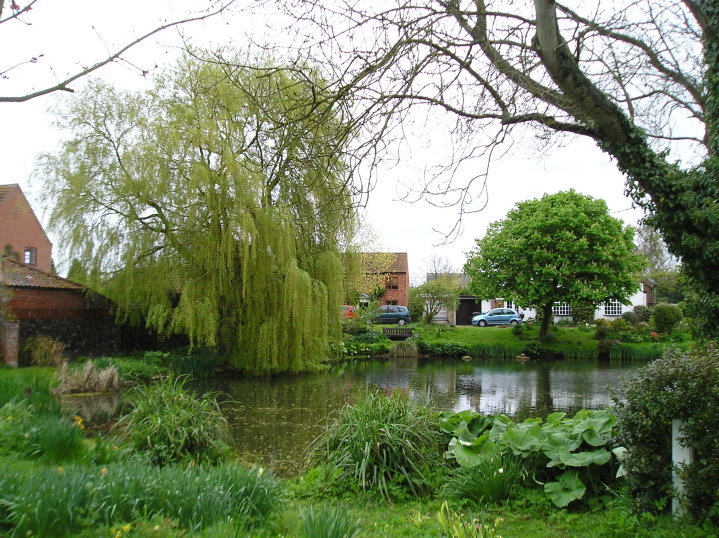
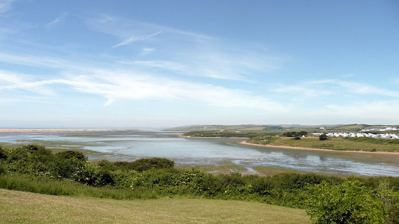
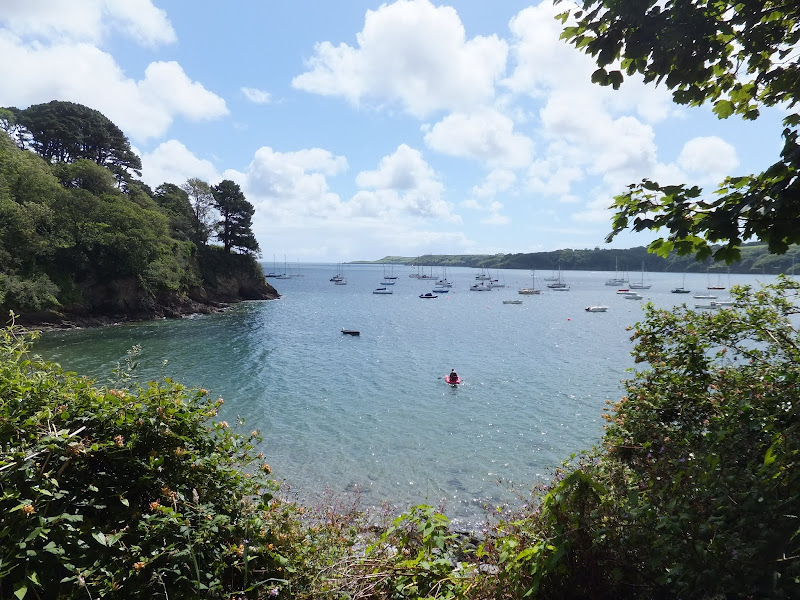
This section of the South West Coast Path was set around a base camp at the Bagwell touring site at Langton Herring. This site is close to the road into Weymouth providing easy access to public transport and close to the Coast Path with footpaths leading down to the trail just below Langton Herring village. The path follows the waterline of the Fleet, the enclosed waters that sit between the mainland and Chesil Beach, the large shingle Bank that stretches all the way through to Portland, the island at the southern tip of Weymouth.

The path cuts across a small headland known as Herbury and then past Moonfleet Manor House a large 30 room Georgian building used as a hotel and spa. The house is the central location for the namesake novel by J. Mead Faulkner set in times when piracy and smuggling abounded. The name of the house is derived from Maximillion Mohune who built the house, literally Mohunes of Fleet which was corrupted to Moonfleet.

The walk is easy and relaxed with no real challenges, more like an amble in the park rather than a hike along the South West Coast Path. Given a glorious sunny day such as that when this instance of the walk was undertaken, it really is an utter pleasure to wander.

The path on this section ends at Ferry Bridge, the connecting point between the mainland and Portland where a road leads across to the island via the Ferry Bridge. The Ferry Bridge Inn stood here, in a prominent position with views across to Portland and westwards along the Fleet. One would have thought such a position would deem it to be a busy pub but certainly this was not the case on visiting during this walk when we were the only patrons. The pub has since closed and has subsequently been demolished.

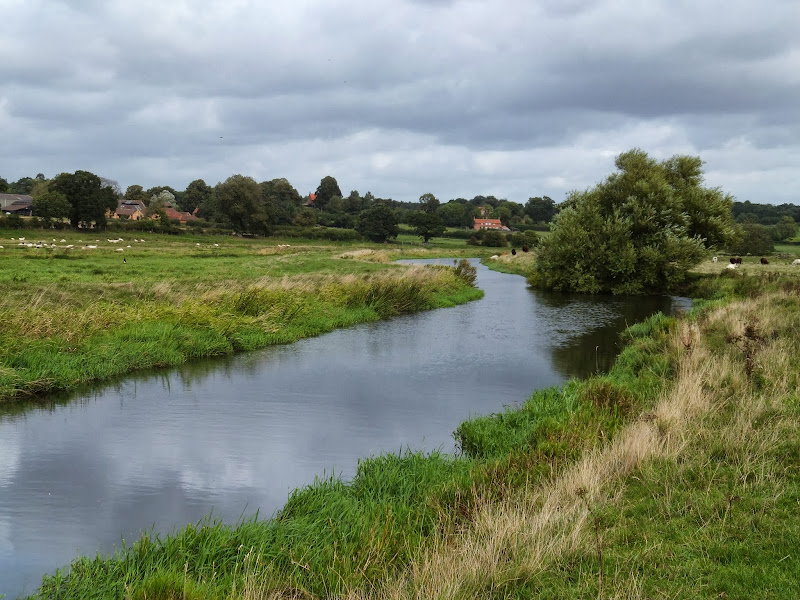
The coast path continues with a circular walk around Portland. That is a section left for another walk day and detailed on Portland Circular Walk. For this walk we continue into Weymouth town, following the route of the former Portland Branch Line. The path diverges from the old trackbed at the Nothe Peninsular where a 19th century fort sits at its head. This peninsular forms a natural harbour on its northern side where the River Wey drains into the sea. One one can walk up to the Town Bridge to cross the river, but it is much more fun to take the ferry and witness the numerous sailing craft moored on either side. A fish eye view of the river. Well a sailors eye view anyway. On this expedition the Pelican sailing ship was moored in the harbour. Built in 1948 this tall ship made its living as an arctic trawler before being restored in 2007 and subsequently used as a sail training ship. A magnificent sight.

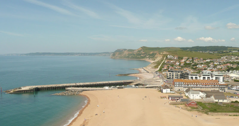
The town of Weymouth sits on a sheltered bay at the mouth of the River Wey. It was built as a prominent seaport whose trade dates back to medieval times. In these modern times it thrives on tourism and is an unabashed, unashamed English seaside resort with all the connotations that one expects from such. Kiss me quick hats. Ice Cream. Sandy Beaches where holidaymakers soak up the sun. Not the place for the rural aficionado such as myself but nonetheless it still presents that sense of arrival. After walking the coast path from Exmouth, this is the first major town and such civilisation marks an arrival, a completion of a major section. Because Weymouth and Portland jut out into the English Channel the coast eastwards is always hidden from view when walking from the west. From Weymouth a whole new challenge is presented ahead with the coastline stretching around to Lulworth and Kimmeridge and beyond.

There are buses from Weymouth back to the campsite including the Jurassic Coast service which runs past the site entrance. Later buses run through to Chickerell which is a short one mile walk back to the campsite. On this occasion a later bus was caught which did present the unwitting passenger to the less salubrious side of the town where Feral youths stand in the road purposefully forcing the bus to stop with scowls on their faces and abusive words from their mouths and sign language that did not take someone who was proficient in such skills to interpret. It is a sad fact that such reprobates fail to see the beauty that is around them. This coast is a glory with so much to explore yet they appear to restrict themselves to the concrete urbanisation.

Saturday 9 February 2019

South West Coast Path - West Bay to Abbotsbury

Hills above Charmouth

A 9 mile walk along the South West Coast Path between West Bay and Abbotsbury

One of the easier sections of the South West Coast Path as the cliffs taper down to present the start of Chesil Beach, a vast shingle bank that stretches from Abbotsbury through to Portland.

The climb out of West Bay is a steep ascent up to 45m and the summit of East Cliff. This is the only real challenge on this walk. The cliffs become notably smaller and the going becomes easier. At Buron Bradstock the path descends back down to beach level and follows the perimeter of a holiday park along the side of the River Bride to a bridge although the water looks shallow and placid enough to wade across as the river twists around the shingle and exudes across the beach.

By the time one gets to Codgen Beach there are no cliffs, just the beach that merges into the grassy landscape with an undulating hillscape beyond. Ahead Portland clearly shows itself. The path leads across the head of the beach and at times it is difficult going underfoot. It is a relief to head on the grassy paths that lead behind Burton Mere but it eventually leads back onto the shingle beach.

Beyond Bexington the path improves and continues through to where it heads inland to Abbotsbury, circling around the base of Chapel Hill, where St Catherines Chapel sits ominously on its summit. At this point the coast path doubles back on itself to continue on to Langton Herring. On this instance of the walk, with having to travel from Salcombe Regis using public transport, it left little time for walking. This is the furthest distance that was used from tht specific campsite, reloating to Langton Herring the next day. In retrospect it would have been more convienient to have undertaken this walk from the Langton Herring campsite.

The bus stop in Abbotsbury is outside the Illchester Arms, a 17th century former coaching inn that is well worth paying a visit, the interior welcoming and cosy with its oak beamed ceilings. The pub is said to be haunted and there are numerous ghostly tales associated with the inn including the sounds of coins jangling by a ghostly coin collector, a spectre of a woman who haunts the toilets and the apparition of a Royalist Soldier from the civil war who was reputedly hanged here when caught by Parliamentarians.

Saturday 26 January 2019

An Extended Walk around the Rendlesham UFO Trail

A 12 mile circular walk starting at Eyke and incorporating the UFO Trail in Suffolk's Rendlesham Forest

The Rendlesham UFO trail is a waymarked 3 mile trail around the eastern end of Rendlesham Forest that navigates around the key areas that were involved in the Rendlesham Forest Incident of 1980 in which both civilian and military personnel witnessed unexplained craft land within the forest. Although this can be walked by parking up at the visitor car-park in the forest, a longer alternative is to take the footpaths from Eyke, and make a day of this most wonderful and intriguing part of Suffolk.

Thursday 24 January 2019

Angles Way - Earsham to Beccles

Waveney Valley from Mettingham

A 12 mile walk along the Angles Way between Earsham and Beccles

The walk starts by heading up the hills that overlook Outney Common. This is a really rewarding start to an easy ramble that continues across the Waveney Valley to Mettingham before continuing down the Waveney Valley. Although Geldeston is on the opposite side of the river to The Angles Way the excursion across the Shipmeadow marshes is well worth the effort to visit the unique Geldeston Locks Inn.

Tuesday 22 January 2019

South West Coast Path - Falmouth to Helford Passage

Durgan

A 10 mile walk along the Cornish section of the South West Coast Path between Falmouth and the Helford Crossing

A picturesque walk following the coast on from the Fal estuary round to the Helford River where a ferry links the village of Helford. The views are spectacular throughout this moderately challenging walk and includes a glorious stroll across the pasture-land around Rosemullion Head.

Monday 21 January 2019

An Amble up the Deben Estuary

Felixstowe Ferry

A 13 mile walk along the River Deben in Suffolk, starting at Felixstowe and ending in Martlesham

The lovely walk along the Deben estuary. Although parts are inaccessible due to breaches of the flood banks, the mix of riverside paths, country lanes and footpaths provides an ideal mix of landscapes to keep any walker fascinated. The May bush pub offers a perfect place to take a rest and refreshment, its riverside location unbeatable.

Friday 18 January 2019

A Walk through the Garden of Suffolk

A 14 mile walk between Saxmundham and Darsham along the East Suffolk Line Walk.

It is Yoxford that gives us the name of this walk which is part of the East Suffolk Line Walks and this specific ramble extends the line walk to return to Leiston where a regular bus service connects the two ends. Yoxford sits on the banks of the River Yox surrounded by three country house parks; Sibton Park that contains large well stocked fishing lake; Grove Park situated in the village; and Rookery Park on the Leiston road. This has earned Yoxford the name of the 'Garden of Suffolk'. The whole route of this walk is a pleasant amble through the rural fields of Suffolk with a return journey through the pretty country lanes following the Minsmere river through to Middleton, Theberton and finally Leiston.

Walk Summaries

Latest walk summaries are basic information sheets for walks that have yet to be fully documented. These provide links to maps, public transport and walks stats, although detailed notes and features are not included.

Latest Walk Summaries

Featured Walk

In Search of Sizewell Chapel

A 10 mile walk following the southern side of the parish boundary of Leiston in Suffolk This walk follows the route of a 17th century peramb...

What is GPX

All you need to know about GPX, electronic mapping and how to use modern apps and mobile devices as navigation devices

Popular Walks

Maps