Route details, maps, pubs, features, local history and folklore for a wide variety of walks focusing primarily on Norfolk and Suffolk

diversion Walks
Showing posts with label diversion. Show all posts

Wednesday, 3 September 2025

In Search of the ruins of Leiston Abbey

A 10 mile circular walk around Leiston and Eastbridge in Suffolk

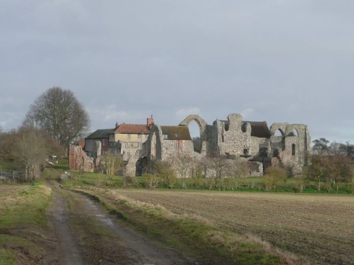
Leiston Abbey was originally founded in the late 12th century by Ranulf de Glanville. The original building was constructed on an island in the Minsmere marshes. Two centuries later, due to the inhospitable conditions on the marsh and constant flooding the Abbey was moved inland, lock stock and stone to a site close to Leiston. Despite a great fire in 1367 and much demolition following the dissolution of the monasteries there still remains some impressive ruins. There is still a remnant of the old Abbey, with the former chapel building sitting in its island position above the marsh, decaying into the landscape and containing a WWII pill box. This walk visits both sites making a well worthwhile walk.

The Sandlings Walk - Knodishall to Snape

A 13 mile circular walk along the Sandlings Walk between Knodishall and Snape

With limited public transport this walk offers a circular route to incorporate the Sandlings path from Knodishall to Snape. Starting and ending at nearby Leiston it incorporates The Sailors Path and the Suffolk Coast Path to make a worthwhile day walk. The route passes Friston mill and Hall and the burial grounds where a Saxon burial ship was discovered. With pubs at Friston and Snape it provides for a great days ramble.

Sunday, 6 February 2022

Leiston To Yoxford Circular Walk

Leiston To Yoxford Circular Walk

Exploring the countryside between the East Suffolk villages of Leiston and Suffolk

This is a walk to celebrate the glorious working landscape of East Suffolk. With the option of two pubs at Yoxford this makes for a good days rambling

Tuesday, 7 January 2020

In Search of the Lost City of Dunwich

A circular walk between Leiston and Dunwich

This walk uses the beach and the Sandlings Path to provide a days walk to Dunwich from Leiston via Sizewell. One should time this walk such that the beach is walked a couple of hours either side of low tide when there is a little sand to walk along. At other times the beach is predominantly shingle and the walker may find it easier to follow the Suffolk Coast Path which is waymarked from the north side of Minsmere where it continues up onto the cliffs.

Monday, 7 January 2019

A Walk to the Dunwich Leper Chapel

Leper Chapel

A 14.25 mile circular walk between Leiston to Dunwich

A simple walk using the Suffolk Coast Path from Sizewell to Dunwich with a visit to the ruins of the 12th century Leper Chapel. The return uses the the footpath via Mount Pleasant to get onto the Sandlings Path across Dunwich Heath to return back to Leiston.

Friday, 4 January 2019

A Walk Around the Churches of Knodishall and Friston

An 8.4 mile circular walk around the Suffolk villages of Knodishall and Friston

An easy ramble across the Suffolk countryside, with the highlight being the hidden ruins of St Peters Church in the old parish of Buxlow, now a part of Knodishall. There's some fascinating history on this walk along paths that are off the beaten track but nonetheless well maintained.

Friday, 10 August 2018

Leiston to Buxlow Church Ruins - Walk Summary

Salt marsh

A country ramble to the lost parish of Buxlow

This walk provides a days ramble to view the ruins of Buxlow church. Many may have never heard of the parish of Buxlow, even those local to the area, and they can be forgiven for their ignorance since the parish was consolidated with Knodishall on 22nd February 1721.

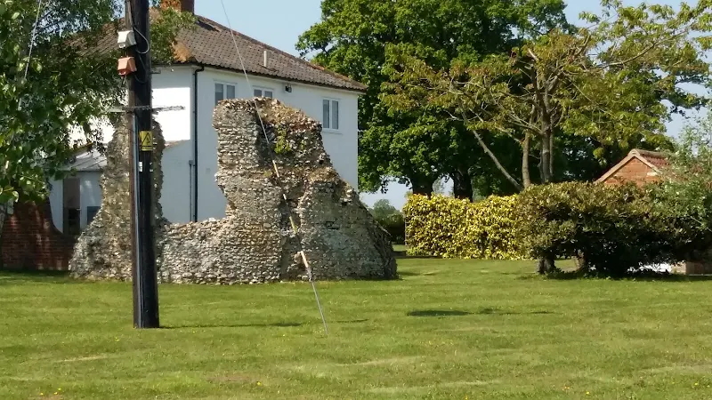
Little is left of Buxlow church, which was dedicated to St Peter. There is merely a remnant of a wall from the old round tower that now rests in the garden of a domestic house which is viewable from the track that runs between the two houses. There are suggestions that the church was one of those recorded for Knodishall in the Domesday book and records certainly show there was a rector of the parish from 1301 onwards. By the middle of the 17th century it was reported to be 'decayed and ruinated tyme out of mind' although a rectors of the parish were still being recorded up to 1716 when Robert Witchingham held the honour.

Whilst admiring this piece of history the lady from the adjacent house engaged us in conversation stating that there have been many archaeological finds in the fields to front of the ruins. She even remarked of the many Roman coins that were constantly being unearthed. This is certainly not recorded on the Suffolk Heritage website so this is merely word of mouth. This does spark the imagination as the nearby hamlet of East Green is one of the suggestions of the long lost Roman station of Sitomagus. Maybe there was a connection from East Green to Aldringham which local folklore states was was a Roman port, the river Hundred in those days said to be navigable to sea going ships.

Note that a similar walk is described on this site with an alterntive route. This can be found on the page titled A Walk Around the Churches of Knodishall and Friston.
East Suffolk PRoW Access

The Public Rights of Way (PRoW) within the Suffolk Coastal area between Aldeburgh and Southwold are subject to being blocked up and diverted due to the extensive industrial projects that are currently taking place in the area including the Sizewell C development and various wind farm projects. A PRoW Access page has been written to detail known issues in the area

Walk Summaries

Latest walk summaries are basic information sheets for walks that have yet to be fully documented. These provide links to maps, public transport and walks stats, although detailed notes and features are not included.

Latest Walk Summaries

Featured Walk

In Search of Sizewell Chapel

A 10 mile walk following the southern side of the parish boundary of Leiston in Suffolk This walk follows the route of a 17th century peramb...

What is GPX

All you need to know about GPX, electronic mapping and how to use modern apps and mobile devices as navigation devices

Popular Walks

Maps

Diary of a Suffolk Common

The ramblings and musing of the Griffmonster